
Queenstown, New Zealand facts for kids
Quick facts for kids
Queenstown
Tāhuna (Māori)
|
|
|---|---|
|
Resort town
|
|
.jpg)
Queenstown from Bob's Peak
|
|
| Country | New Zealand |
| Region | Otago |
| Territorial authority | Queenstown-Lakes District |
| Named | January 1863 |
| Founded by | William Gilbert Rees |
| Electorates | Southland Te Tai Tonga |
| Area | |
| • Urban | 86.61 km2 (33.44 sq mi) |
| Elevation | 330 m (1,080 ft) |
| Population
(June 2023)
|
|
| • Urban | 29,000 |
| • Urban density | 335/km2 (867/sq mi) |
| • District | 52,800 |
| Time zone | UTC+12:00 (NZST) |
| • Summer (DST) | UTC+13:00 (NZDT) |
| Postcode(s) |
9300
|
| Area code(s) | 03 |
| Local iwi | Ngāi Tahu |
Queenstown (Māori: Tāhuna) is a lively resort town in the south-west of New Zealand's South Island. It's located in the Otago region and is the main town in the Queenstown-Lakes District.
The town sits on the edge of Lake Wakatipu. This lake is long, thin, and Z-shaped, carved out by glaciers long ago. Queenstown offers amazing views of mountains like The Remarkables, Cecil Peak, Walter Peak, and Ben Lomond. Queenstown is famous for its tourism, especially for exciting adventure sports and skiing.
Contents
What's in a Name?
The Māori name for Queenstown is Tāhuna. It means 'shallow bay'.
There are a few stories about how Queenstown got its English name. The most likely one goes like this:
When William Rees first came to this area, he built his home. The place was first called The Station. Later, miners called it The Camp from 1860 to 1862. These miners, especially those from Ireland, knew about a town in Ireland called Cobh. It was renamed Queenstown in 1850 to honor Queen Victoria.
In January 1863, a public meeting was held to name the new 'township on the lake'. They officially chose 'Queenstown' to remember the Irish town. By January 9–10, 1863, newspapers were already using the name Queenstown.
Queenstown's Past
Early Māori Life
Māori were the first to discover and settle this area. The Kāi Tahu people say that Lake Wakatipu was dug by their ancestor, Rākaihautū. He used his special digging stick called Tūwhakaroria.
The first non-Māori person to see Lake Wakatipu was Nathanael Chalmers in September 1853. He was guided by Reko, a Māori chief. Signs like stake nets and spears show that Māori visited the Glenorchy area. It's likely Ngāi Tahu Māori came to Queenstown to gather Pounamu (greenstone). There was once a Māori settlement called Te Kirikiri Pa where the Queenstown Gardens are now. However, it was no longer used when Europeans arrived in the 1860s.
European Settlers Arrive
William Gilbert Rees and Nicholas von Tunzelmann were the first non-Māori to settle here. Rees started a farm in 1860 where Queenstown's town center is today. But in 1862, gold was found in the Arrow River. This led Rees to turn his wool shed into a hotel called the Queen's Arms, now known as Eichardt's.
Many streets in Queenstown still have names from the gold mining days, like Camp Street. Some old buildings are still standing. William's Cottage, the Lake Lodge of Ophir (now Artbay Gallery), Queenstown Police Station, and St Peter's Anglican Church are all close together in a historic area.
The 1999 Flood
In November 1999, heavy rain caused Lake Wakatipu to rise a lot. The lake level went up by over 2 meters. This led to the worst flooding Queenstown had ever seen. Buildings near the lake in central Queenstown were flooded up to 1 meter deep, causing a lot of damage.
Queenstown's Location
Queenstown is on the shore of Lake Wakatipu, New Zealand's third-largest lake. The town is near a bend in the lake, where a small arm called the Frankton Arm connects to the Kawarau River. The town center is on the north shore. The suburb of Frankton is at the eastern end of the arm, and Kelvin Heights is across the water on the Kelvin Peninsula.
Queenstown is quite low for a ski town, at 310 metres (1,020 ft) above sea level. But it's surrounded by mountains, like the beautiful The Remarkables to the southeast. Below the lake is the deep Kawarau Gorge. There are also flat areas nearby good for farming and growing grapes for wine. Queenstown is in the heart of the Central Otago wine region.
Nearby Areas
Central Queenstown has many shops, apartments, and homes. It's surrounded by suburbs like Fernhill, Sunshine Bay, Queenstown Hill, Goldfield Heights, Marina Heights, Kelvin Heights, Arthurs Point and Frankton.
Just outside Queenstown, you'll find areas like Arrowtown, Closeburn, Dalefield, Gibbston, Jack's Point, Hanley's Farm, Lake Hayes Estate, and Shotover Country.
.jpg)
Weather in Queenstown
Queenstown has an oceanic climate. This means it has warm summers and cold winters. Summer days are long and can reach 30 °C. Winters are cold, often with temperatures in single digits and frequent snowfall. However, snow doesn't stay on the ground all year.
Queenstown gets less rain than places closer to the west coast because it's in the rain shadow of the Southern Alps. The hottest temperature ever recorded in Queenstown was 35.2 °C (95 °F). The coldest was −8.4 °C (17 °F).
| Climate data for Queenstown Airport (1991–2020 normals, extremes 1968–present) | |||||||||||||
|---|---|---|---|---|---|---|---|---|---|---|---|---|---|
| Month | Jan | Feb | Mar | Apr | May | Jun | Jul | Aug | Sep | Oct | Nov | Dec | Year |
| Record high °C (°F) | 33.4 (92.1) |
32.2 (90.0) |
30.0 (86.0) |
25.1 (77.2) |
21.3 (70.3) |
19.4 (66.9) |
17.9 (64.2) |
19.7 (67.5) |
23.3 (73.9) |
26.0 (78.8) |
28.5 (83.3) |
30.0 (86.0) |
33.4 (92.1) |
| Mean maximum °C (°F) | 28.3 (82.9) |
27.9 (82.2) |
25.3 (77.5) |
21.2 (70.2) |
18.0 (64.4) |
14.7 (58.5) |
13.9 (57.0) |
15.6 (60.1) |
18.8 (65.8) |
21.9 (71.4) |
24.1 (75.4) |
26.9 (80.4) |
29.5 (85.1) |
| Mean daily maximum °C (°F) | 22.0 (71.6) |
21.8 (71.2) |
19.1 (66.4) |
15.2 (59.4) |
11.9 (53.4) |
8.6 (47.5) |
8.2 (46.8) |
10.2 (50.4) |
13.0 (55.4) |
15.4 (59.7) |
17.5 (63.5) |
20.2 (68.4) |
15.3 (59.5) |
| Daily mean °C (°F) | 15.9 (60.6) |
15.6 (60.1) |
13.2 (55.8) |
9.8 (49.6) |
7.1 (44.8) |
4.1 (39.4) |
3.4 (38.1) |
5.2 (41.4) |
7.7 (45.9) |
9.9 (49.8) |
11.9 (53.4) |
14.3 (57.7) |
9.8 (49.6) |
| Mean daily minimum °C (°F) | 9.9 (49.8) |
9.5 (49.1) |
7.3 (45.1) |
4.5 (40.1) |
2.3 (36.1) |
−0.4 (31.3) |
−1.4 (29.5) |
0.2 (32.4) |
2.4 (36.3) |
4.4 (39.9) |
6.2 (43.2) |
8.5 (47.3) |
4.5 (40.1) |
| Mean minimum °C (°F) | 3.4 (38.1) |
3.1 (37.6) |
1.3 (34.3) |
−1.3 (29.7) |
−3.1 (26.4) |
−5.0 (23.0) |
−6.2 (20.8) |
−4.4 (24.1) |
−2.9 (26.8) |
−1.7 (28.9) |
−0.2 (31.6) |
2.4 (36.3) |
−6.4 (20.5) |
| Record low °C (°F) | 0.3 (32.5) |
0.5 (32.9) |
−1.6 (29.1) |
−4.5 (23.9) |
−8.8 (16.2) |
−10.3 (13.5) |
−12.2 (10.0) |
−7.8 (18.0) |
−5.0 (23.0) |
−4.2 (24.4) |
−2.1 (28.2) |
−1.0 (30.2) |
−12.2 (10.0) |
| Average rainfall mm (inches) | 71.6 (2.82) |
51.0 (2.01) |
49.3 (1.94) |
57.5 (2.26) |
75.1 (2.96) |
62.2 (2.45) |
55.8 (2.20) |
52.8 (2.08) |
62.3 (2.45) |
62.4 (2.46) |
60.7 (2.39) |
60.3 (2.37) |
721 (28.39) |
| Average rainy days (≥ 1.0 mm) | 7.6 | 6.5 | 7.3 | 7.3 | 9.7 | 8.6 | 7.8 | 8.1 | 8.3 | 8.4 | 7.7 | 8.7 | 96 |
| Average relative humidity (%) | 69.7 | 75.5 | 78.4 | 79.9 | 83.8 | 86.1 | 85.4 | 82.1 | 74.1 | 72.6 | 68.9 | 69.1 | 77.1 |
| Mean monthly sunshine hours | 236.9 | 209.3 | 180.0 | 136.2 | 83.8 | 69.3 | 85.2 | 119.5 | 151.0 | 197.0 | 217.9 | 212.6 | 1,898.7 |
| Mean daily daylight hours | 15.2 | 13.9 | 12.4 | 10.8 | 9.5 | 8.8 | 9.2 | 10.3 | 11.8 | 13.4 | 14.8 | 15.6 | 12.1 |
| Percent possible sunshine | 50 | 53 | 47 | 42 | 28 | 26 | 30 | 37 | 43 | 47 | 49 | 44 | 41 |
| Source 1: NIWA | |||||||||||||
| Source 2: Weather Spark | |||||||||||||
| Climate data for Queenstown Gardens (1991–2020 normals, extremes 1871–1881, 1930–2021) | |||||||||||||
|---|---|---|---|---|---|---|---|---|---|---|---|---|---|
| Month | Jan | Feb | Mar | Apr | May | Jun | Jul | Aug | Sep | Oct | Nov | Dec | Year |
| Record high °C (°F) | 35.2 (95.4) |
33.4 (92.1) |
30.7 (87.3) |
27.3 (81.1) |
21.7 (71.1) |
19.8 (67.6) |
17.6 (63.7) |
20.5 (68.9) |
24.3 (75.7) |
26.8 (80.2) |
29.8 (85.6) |
31.7 (89.1) |
35.2 (95.4) |
| Mean maximum °C (°F) | 30.0 (86.0) |
29.6 (85.3) |
26.7 (80.1) |
22.3 (72.1) |
18.7 (65.7) |
15.2 (59.4) |
14.4 (57.9) |
16.4 (61.5) |
19.9 (67.8) |
23.1 (73.6) |
25.7 (78.3) |
28.4 (83.1) |
31.1 (88.0) |
| Mean daily maximum °C (°F) | 23.4 (74.1) |
23.2 (73.8) |
20.5 (68.9) |
16.3 (61.3) |
12.6 (54.7) |
9.4 (48.9) |
9.0 (48.2) |
11.0 (51.8) |
14.0 (57.2) |
16.7 (62.1) |
19.0 (66.2) |
21.6 (70.9) |
16.4 (61.5) |
| Daily mean °C (°F) | 17.2 (63.0) |
16.9 (62.4) |
14.6 (58.3) |
11.2 (52.2) |
8.2 (46.8) |
5.2 (41.4) |
4.6 (40.3) |
6.3 (43.3) |
8.9 (48.0) |
11.1 (52.0) |
13.1 (55.6) |
15.6 (60.1) |
11.1 (52.0) |
| Mean daily minimum °C (°F) | 11.0 (51.8) |
10.6 (51.1) |
8.6 (47.5) |
6.0 (42.8) |
3.7 (38.7) |
1.1 (34.0) |
0.2 (32.4) |
1.6 (34.9) |
3.8 (38.8) |
5.5 (41.9) |
7.3 (45.1) |
9.6 (49.3) |
5.8 (42.4) |
| Mean minimum °C (°F) | 5.2 (41.4) |
5.2 (41.4) |
3.5 (38.3) |
1.3 (34.3) |
−0.5 (31.1) |
−2.8 (27.0) |
−3.9 (25.0) |
−2.3 (27.9) |
−0.7 (30.7) |
0.5 (32.9) |
1.8 (35.2) |
4.2 (39.6) |
−4.3 (24.3) |
| Record low °C (°F) | 0.7 (33.3) |
1.2 (34.2) |
0.0 (32.0) |
−1.7 (28.9) |
−6.7 (19.9) |
−6.6 (20.1) |
−8.4 (16.9) |
−6.1 (21.0) |
−4.1 (24.6) |
−2.5 (27.5) |
−1.6 (29.1) |
0.8 (33.4) |
−8.4 (16.9) |
| Average rainfall mm (inches) | 78.6 (3.09) |
65.0 (2.56) |
60.2 (2.37) |
68.9 (2.71) |
90.7 (3.57) |
74.8 (2.94) |
73.0 (2.87) |
82.1 (3.23) |
81.3 (3.20) |
83.3 (3.28) |
75.9 (2.99) |
75.3 (2.96) |
909.1 (35.77) |
| Source: NIWA | |||||||||||||
Flood Risks
Some low areas of Queenstown near Lake Wakatipu can flood. This happens because during heavy rain or melting snow, water flows into the lake faster than it can flow out. The Kawarau River is the main outflow, but its path is narrow, which can slow the water down.
Because of this, Queenstown has flooded many times. When the lake reaches 311.3 meters, water can back up into the town's stormwater system. This has happened about 20 times since 1878.
People of Queenstown
Queenstown is a medium-sized urban area in New Zealand. Its population has been growing very quickly. In 2016, it became the second-largest urban area in Otago, after Dunedin.
| Historical population | ||
|---|---|---|
| Year | Pop. | ±% p.a. |
| 2006 | 10,428 | — |
| 2013 | 11,334 | +1.20% |
| 2018 | 13,539 | +3.62% |
At the 2018 New Zealand census, Queenstown had a population of 13,539 people. This was a big increase from previous years. There were more males than females living in the town. About 9.9% of the people were under 15 years old.
Most people in Queenstown are of European descent (71.2%). There are also people of Māori (4.5%), Asian (17.8%), Pacific (1.2%), and other backgrounds. Many people (58.3%) were born outside New Zealand.
Most people (58.5%) said they had no religion. About 29.1% were Christian, and others followed different religions like Hindu or Buddhist.
Many adults in Queenstown have a university degree (26.5%). Most people (75.1%) work full-time.
| Name | Area (km2) | Population | Density (per km2) | Households | Median age | Median income |
|---|---|---|---|---|---|---|
| Frankton | 7.62 | 2,895 | 380 | 1,017 | 32.8 years | $39,300 |
| Frankton Arm | 1.20 | 1,917 | 1,598 | 603 | 31.2 years | $41,200 |
| Kelvin Heights | 9.28 | 1,170 | 126 | 447 | 43.4 years | $44,800 |
| Queenstown Central | 0.81 | 1,017 | 1,256 | 261 | 30.0 years | $34,300 |
| Quail Rise | 6.27 | 708 | 113 | 234 | 40.5 years | $49,200 |
| Queenstown East | 0.98 | 1,416 | 1,445 | 441 | 30.5 years | $38,800 |
| Sunshine Bay-Fernhill | 1.31 | 2,931 | 2,237 | 861 | 29.6 years | $37,600 |
| Warren Park | 0.94 | 1,485 | 1,580 | 390 | 28.7 years | $34,200 |
| New Zealand | 37.4 years | $31,800 |
Queenstown's Economy
Queenstown's economy is very important to the wider Queenstown-Lakes District. This district also includes towns like Wānaka, Glenorchy, and Kingston.
Housing in Queenstown
Homes in Queenstown are quite expensive. This is because it's a popular tourist spot, there isn't much land available, and many people want to live or invest there. In 2017, Queenstown became the least affordable place to buy a home in New Zealand. The average house price reached $1 million NZD in December 2016.
To help with housing, the New Zealand Government approved a project in October 2022. This project will build 748 new homes at Lake Hayes Estate. It will also include a public transport area and possibly a school.
Jobs in Queenstown
Queenstown is one of the fastest-growing areas in New Zealand for jobs. Most jobs are related to tourism or providing places to stay. In 2016, job growth in Queenstown was the highest in New Zealand.
Shopping Fun
Queenstown has a shopping area designed for tourists, called the Queenstown Mall. It opened in 1990 and has shops and a cinema.
O'Connells Shopping Centre also opened in 1990. Shops in Queenstown can open almost every day of the year. This is special because in most of New Zealand, shops have to close on Sundays and public holidays.
Fun Things to Do


Tourism is a huge part of Queenstown's economy. People come here for outdoor and adventure tourism. You can enjoy:
- Skiing and snowboarding at four main ski fields: Cardrona Alpine Resort, Coronet Peak, The Remarkables, and Treble Cone.
- Exciting activities like jet boating, whitewater rafting, and bungy jumping.
- Outdoor sports like mountain biking, skateboarding, tramping, paragliding, sky diving, and fly fishing.
You can also ride a historic steamship, the TSS Earnslaw, on Lake Wakatipu.
Queenstown is near the Central Otago wine region, known for its quality Pinot Noir wine. The famous New Zealand actor Sam Neill owns a vineyard here called Two Paddocks. Nearby Arrowtown has great restaurants and bars.
Other popular spots include Ben Lomond, a mountain with amazing views from Skyline Queenstown's gondola. You can visit the Kiwi Park wildlife sanctuary. Paradise is a nearby rural area known for its paradise ducks. The The Queenstown Trail and Skippers Road are popular for walking, running, and biking.
Queenstown's Culture
Festivals and Events
Queenstown hosts many fun festivals throughout the year:
- The ten-day Bike Festival in January.
- The Winter Festival in June.
- The Jazz Festival in October.
- Winter Pride in August–September, which is the largest winter pride event in the Southern Hemisphere.
Filming Locations
Queenstown and its beautiful surroundings have been used as a backdrop for many films and TV shows:
- The drama mystery Top of the Lake was filmed here in 2012.
- Part of America's Next Top Model Cycle 14 was filmed in Queenstown in 2010.
- Many scenes from The Lord of the Rings film trilogy were shot nearby, especially in Paradise near Glenorchy.
- The Bollywood movie Kaho Naa... Pyaar Hai was partly filmed here, making Queenstown popular in South Asia.
- X-Men Origins: Wolverine (2009) and Willow (1988) also used Queenstown for filming.
- The 2017 Filipino film Northern Lights was entirely shot in Queenstown.
- The Korean TV show Running Man filmed an episode here in 2017.
- The 2020 crime drama One Lane Bridge was filmed in Queenstown.
Sports and Fun Activities
Queenstown offers many ways to stay active and have fun:
- Visit the Queenstown Events Centre and stadium.
- Try Paragliding or Hang Gliding.
- Go Aerobatics with the Wakatipu Aero Club at Queenstown Airport.
- Play Golf at Millbrook Resort, Jack's Point, or Queenstown Golf Club.
- Enjoy Disc golf or Tennis at the Queenstown Gardens.
- Play Cricket, Netball, Rugby league, or Rugby union.
- Try Scuba diving or snorkeling in the lake or rivers.
- Experience extreme Adventure sports like canyon-swing, parachute, jetboat, bungy jump, river-surf, or kitesurf.
Explore the Area
There's lots to see and do around Queenstown:
- Discover the Central Otago region and its Central Otago wine region.
- Learn about the history of the Otago gold rush.
- Visit Fiordland National Park, including the Milford Road and Homer Tunnel to Milford Sound / Piopiotahi.
- Go tramping on tracks near Glenorchy, like the Routeburn, one of New Zealand's Great Walks.


Learning in Queenstown
Primary Schools
- Queenstown Primary School is a state school for students in Year 1 to 8. It has 563 students.
- St Joseph's School is a Catholic primary school for Year 1 to 8 students. It has 134 students.
There are also primary schools in Frankton and Shotover Country.
Secondary Schools
- Wakatipu High School is a state secondary school for Year 9 to 13 students. It is located in Frankton.
Higher Education
- The Southern Institute of Technology (SIT) has a campus in Queenstown.
- Queenstown Resort College focuses on training for tourism jobs.
- ACE Wakatipu offers adult training courses for the community.
Churches in Queenstown
Saint Andrew's Church
Saint Andrew's Presbyterian church was finished in 1968. It can seat 350 people. The Presbyterian church has been active in the Queenstown area since 1865.
Saint Peter's Church
Saint Peter's Anglican church was built in 1932. It cost 2862 pounds to build. It replaced an older wooden church from 1863.
Saint Joseph's Church
Saint Joseph's Catholic church was built in 1898. It replaced the first Catholic church in Queenstown, built in 1863. It is made from schist rock from Arthur's Point. This church is a Category Two historic place.
- Queenstown churches
-
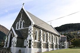
Saint Joseph's Catholic Church
-
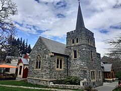
Saint Peter's Anglican Church
-
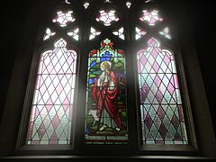
Interior of Saint Peter's Anglican Church
-
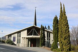
Saint Andrew's Presbyterian Church


How to Get Around
Transport Options
You can reach Queenstown by road and air, but not by train.
Many bus services come to Queenstown, especially for tours. Daily buses also connect Queenstown to Invercargill, Dunedin, and Christchurch.
Queenstown Airport is very busy. It has flights from Australia by airlines like Air New Zealand, Qantas, Virgin Australia, and Jetstar. You can fly to cities like Brisbane, Melbourne, and Sydney. Domestic flights go to Auckland, Christchurch, and Wellington. The airport is also a busy base for helicopters and tourist flights, especially to Milford Sound / Piopiotahi and Aoraki / Mount Cook.
The main road to Queenstown is State Highway 6 (State Highway 6). It comes from Cromwell through the Kawarau Gorge. A short road (SH6A) leads to the town center. There's also a challenging road over the Crown Range to Cardrona and Wānaka, which is New Zealand's highest paved public road pass.
Queenstown is a starting point for many day trips to Milford Sound. These trips take about 12 hours return by bus. You can also take scenic flights to Milford Sound, which are much quicker.
Town Services
In September 2023, some people in Queenstown got sick from cryptosporidium in the water. Health officials issued a "boil water" notice. This happened because one of the water treatment plants didn't have a special filter to stop cryptosporidium.
Electricity in Queenstown is managed by Aurora Energy and Powernet. It comes from a main power station in Frankton.
Queenstown used to have an old-fashioned telephone system where an operator connected all calls. It was updated to a modern automatic system in 1988. Fast internet (fibre optic) was installed in Queenstown by July 2016.
Famous People from Queenstown
- Sam Neill (born 1947), a well-known actor, has a home in Queenstown.
- Tim Bevan (born 1957), a film producer, was born in Queenstown.
- Jaime Passier-Armstrong (born 1981), an actress, was born in Queenstown.
- Jane Taylor, a lawyer and current Chair of New Zealand Post, lives in Queenstown.
Sister Cities
Queenstown has special friendships with other cities around the world:
- Aspen, Colorado, United States
- Hangzhou, Zhejiang, China
- Hikimi, Shimane (now part of Masuda), Japan

See also
 In Spanish: Queenstown (Nueva Zelanda) para niños
