Wayne County, North Carolina facts for kids
Quick facts for kids
Wayne County
|
||
|---|---|---|

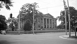
Wayne County Courthouse in Goldsboro
|
||
|
||

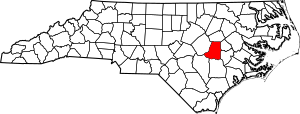
Location within the U.S. state of North Carolina
|
||
 North Carolina's location within the U.S. |
||
| Country | ||
| State | ||
| Founded | 1779 | |
| Named for | Anthony Wayne | |
| Seat | Goldsboro | |
| Largest community | Goldsboro | |
| Area | ||
| • Total | 557.72 sq mi (1,444.5 km2) | |
| • Land | 553.92 sq mi (1,434.6 km2) | |
| • Water | 3.80 sq mi (9.8 km2) 0.68% | |
| Population
(2020)
|
||
| • Total | 117,333 | |
| • Estimate
(2023)
|
118,686 | |
| • Density | 211.74/sq mi (81.75/km2) | |
| Time zone | UTC−5 (Eastern) | |
| • Summer (DST) | UTC−4 (EDT) | |
| Congressional districts | 3rd, 13th | |
Wayne County is a special area in North Carolina, USA. It's called a county. In 2020, about 117,333 people lived here. The main town, or county seat, is Goldsboro. This county is also home to a big air force base called Seymour Johnson Air Force Base.
Wayne County is part of the larger Goldsboro Metropolitan Area. This means Goldsboro is a central city for the surrounding communities.
Contents
History of Wayne County
Before the 1730s, the only people living in what is now Wayne County were Native American tribes. Over time, more settlers started to arrive, especially along the Neuse River. However, most people didn't move here until after 1750. This happened as coastal areas became more crowded, and people looked for new land further west.
Wayne County was officially created on November 2, 1779. This was during the American Revolutionary War. It was formed from the western part of Dobbs County. The county was named after Anthony Wayne, a famous general in the war. He was sometimes called "Mad Anthony" Wayne.
The first court meetings were held at Josiah Sasser's home. Later, in 1787, a town called Waynesborough was started on the west side of the Neuse River. This is where the first courthouse was built.
In 1855, parts of Wayne County and other nearby counties were used to create a new county called Wilson County.
Geography of Wayne County
Wayne County covers about 557.72 square miles. Most of this area, about 553.92 square miles, is land. The rest, about 3.80 square miles, is water.
The land in Wayne County is mostly flat or gently rolling. There are wide, flat areas along the rivers and creeks. The land is usually about 120 to 145 feet above sea level. The biggest river is the Neuse River. It flows through the middle of the county and has a deep channel, about 20 to 40 feet deep. You can find unusual river cliffs near Seven Springs. Other important waterways include the Little River and the Northeast Cape Fear River.
The ground in Wayne County is made of sand, clay, and gravel. These layers were mostly laid down by the sea long ago. This happened as the ocean levels changed over time.
The weather in Wayne County has warm summers and mild winters. The average temperature is around 62 degrees Fahrenheit. The county gets about 50 inches of rain each year. Most of this rain falls in the late spring and summer.
Protected Areas and Sites
Wayne County has several important protected areas and historical sites:
- Charles B. Aycock Birthplace: A historic site.
- Goldsborough Bridge Battlefield: A battlefield from the Civil War.
- Cliffs of the Neuse State Park: A state park with unique river bluffs.
Major Water Bodies
Here are some of the main rivers and creeks in Wayne County:
Neighboring Counties
Wayne County shares borders with these other counties:
- Wilson County – to the north
- Greene County – to the east-northeast
- Lenoir County – to the east-southeast
- Duplin County – to the south
- Sampson County – to the southwest
- Johnston County – to the west
Main Roads
Many important highways pass through Wayne County:


 I-42 / Future I-42


 I-795 / Future I-795
 US 13
US 13 US 70
US 70 US 117


 US 117 Alt.
 NC 50
NC 50 NC 55
NC 55 NC 111
 NC 222
 NC 403
 NC 581
Important Places and Buildings
- Goldsboro Union Station: A train station.
- Seymour Johnson Air Force Base: A large military base.
Population of Wayne County
| Historical population | |||
|---|---|---|---|
| Census | Pop. | %± | |
| 1790 | 6,115 | — | |
| 1800 | 6,772 | 10.7% | |
| 1810 | 8,687 | 28.3% | |
| 1820 | 9,040 | 4.1% | |
| 1830 | 10,331 | 14.3% | |
| 1840 | 10,891 | 5.4% | |
| 1850 | 13,486 | 23.8% | |
| 1860 | 14,905 | 10.5% | |
| 1870 | 18,144 | 21.7% | |
| 1880 | 24,951 | 37.5% | |
| 1890 | 26,100 | 4.6% | |
| 1900 | 31,356 | 20.1% | |
| 1910 | 35,698 | 13.8% | |
| 1920 | 43,640 | 22.2% | |
| 1930 | 53,013 | 21.5% | |
| 1940 | 58,328 | 10.0% | |
| 1950 | 64,267 | 10.2% | |
| 1960 | 82,059 | 27.7% | |
| 1970 | 85,408 | 4.1% | |
| 1980 | 97,054 | 13.6% | |
| 1990 | 104,666 | 7.8% | |
| 2000 | 113,329 | 8.3% | |
| 2010 | 122,623 | 8.2% | |
| 2020 | 117,333 | −4.3% | |
| 2023 (est.) | 118,686 | −3.2% | |
| U.S. Decennial Census 1790–1960 1900–1990 1990–2000 2010 2020 |
|||
2020 Census Information
In 2020, the census counted 117,333 people living in Wayne County. There were 48,482 households and 30,990 families.
The population of Wayne County includes people from many different backgrounds:
| Group | Number | Percentage |
|---|---|---|
| White (not Hispanic) | 60,199 | 51.31% |
| Black or African American (not Hispanic) | 35,329 | 30.11% |
| Native American | 335 | 0.29% |
| Asian | 1,542 | 1.31% |
| Pacific Islander | 71 | 0.06% |
| Other/Mixed | 4,930 | 4.2% |
| Hispanic or Latino | 14,927 | 12.72% |
Economy of Wayne County
Wayne County has many different types of businesses. Some companies do simple assembly work, while others use complex manufacturing processes. They make a variety of products, from bread and animal feed to car parts and electric transformers. Many local factories have added new technology and modern equipment. This has helped them make more products and earn more money.
The county's mild weather and good soil make it a very productive farming area. The growing season without frost lasts about 225 days. In 2006, farms in Wayne County sold about $329 million worth of products.
Field crops like tobacco, corn, cotton, soybeans, and wheat made up about 12% of the farm income. This was about $38.5 million.
Income from livestock (animals) and poultry (chickens, turkeys) was about $236 million in 2006. A big part of this came from raising pigs. Pig farming has grown a lot and is now the biggest source of farm income. In 2006, pig farming brought in about $75.4 million, which was 23% of all farm income. Wayne County is one of the top places in the nation for raising pigs, ranking 7th.
Seymour Johnson Air Force Base is also a huge part of the local economy. It is home to the 4th Fighter Wing and 916th Air Refueling Wing. The base pays over $282 million each year to its civilian and military workers. In 2006, the base's total impact on the economy was over $460 million.
Education in Wayne County
Wayne County has three colleges where students can continue their education:
- Wayne Community College
- University of Mount Olive (which used to be called Mount Olive College)
- The Goldsboro campus of North Carolina Wesleyan University
Public schools in the county are managed by the Wayne County Public Schools system. This system includes:
- Nine high schools and college preparation schools
- Nine middle schools
- Fourteen elementary schools
- One special education school
The county also has one public charter school and six private schools.
High Schools
- Charles B. Aycock High School
- Eastern Wayne High School
- Goldsboro High School
- Rosewood High School
- Southern Wayne High School
- Wayne School of Engineering
- Wayne School of Technical Arts
Media
- The Goldsboro News-Argus: A local newspaper.
- Mount Olive Tribune: Another local newspaper.
Hospitals
- Wayne UNC Health Care: This medical center is in Goldsboro and is the county's second-largest employer.
- Cherry Hospital: A psychiatric hospital in Goldsboro. It was started in 1880. There is a museum on the hospital campus that shows its history.
- O'Berry Neuro-Medical Center: This hospital helps people with developmental disabilities, like Down Syndrome. It offers services to help them live better lives.
Communities in Wayne County
City
- Goldsboro (This is the main town and the county seat.)
Towns
Villages
Census-designated places
These are areas that are like towns but are not officially incorporated:
Other Unincorporated Communities
These are smaller communities that are not officially part of a city or town:
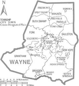
Townships
These are smaller divisions of the county, often used for administrative purposes:
- Brogden
- Buck Swamp
- Fork
Notable People from Wayne County
Many interesting people have come from Wayne County:
- Charles Brantley Aycock: A politician.
- Bob Boyd: A golfer.
- Moira Crone: An author.
- Ava Gardner: A famous actress.
- Anne Jeffreys: An actress.
- Carl Kasell: A radio personality.
- Martin Lancaster: A former president of the North Carolina Community College System.
- Manny Lawson: An NFL linebacker.
- Jerry Narron: A MLB player, coach, and manager.
- Tony Schiffman: A jeweler.
- John R. Smith: A politician.
- Michale Spicer: An NFL defensive end.
- Greg Warren: An NFL long snapper.
- James B. Whitfield: A lawyer.
- Cadmus M. Wilcox: A general in the Confederate army.
Images for kids
See also
 In Spanish: Condado de Wayne (Carolina del Norte) para niños
 | Georgia Louise Harris Brown |
 | Julian Abele |
 | Norma Merrick Sklarek |
 | William Sidney Pittman |


