Connecticut Western Reserve facts for kids
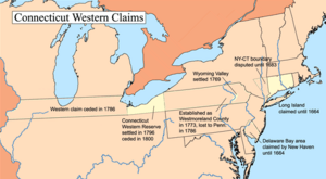
The Connecticut Western Reserve was a special area of land that the Colony of Connecticut and later the state of Connecticut once claimed. This land is now mostly the northeastern part of Ohio. King Charles II of England first gave this land to the Connecticut Colony in its original charter.
After the American Revolutionary War, Connecticut gave up some of its western land claims to the United States in 1786. This happened before the Northwest Territory was created in 1787. Even though Connecticut gave up control of the land, it kept ownership of the eastern part of this area, which was south of Lake Erie. This part became known as the "Western Reserve." Connecticut later sold much of this land to a group of investors called the Connecticut Land Company. These investors then sold smaller pieces of the land to new settlers.
Today, you can still find the name "Western Reserve" in many places in Ohio. For example, there's Western Reserve Academy, Case Western Reserve University, and Western Reserve Hospital. In the 1800s, this area was known for being very against slavery. Someone even called it "the New England of the West" in 1859.
Where Was the Western Reserve?
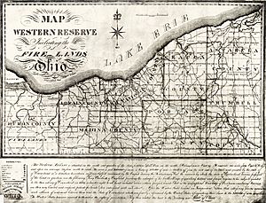
The Western Reserve covered all of these counties in Ohio:
- Ashtabula
- Cuyahoga
- Erie (including the Firelands)
- Huron (including the Firelands)
- Geauga
- Lake
- Lorain
- Medina
- Portage
- Trumbull
It also included parts of these counties:
History of the Western Reserve
Before European settlers arrived, the Erie people lived along the southern shore of Lake Erie. After a war with the Iroquois from 1654 to 1656, the Erie people were almost completely gone. Any survivors joined other tribes, mostly the Seneca.
After the American Revolutionary War, the federal government made Connecticut give up its claim to land in what is now Pennsylvania. But Connecticut held onto its claim for the land in Ohio. This land was a 120-mile-wide strip between Lake Erie and a line just south of cities like Youngstown and Akron. This line was about 3 miles south of today's U.S. Highway 224.
Connecticut gave up its western land claims after the American Revolutionary War. In return, the federal government agreed to take on Connecticut's debt. The government then created the Northwest Territory from these lands. This happened on September 13, 1786. As more people moved into the Northwest Territory, new states were formed in the early 1800s.
Connecticut kept 3,366,921 acres of land in Ohio. This land became known as the "Western Reserve." The state sold the Western Reserve to the Connecticut Land Company in 1796 for $1,200,000. This company was a group of investors, mostly from Suffield, Connecticut. They planned to divide the land into plots and sell it to settlers from the east.
However, the land still belonged to Native American tribes. Clear ownership was gained for the land east of the Cuyahoga River through the Treaty of Greenville in 1795. For the land west of the river, ownership was gained in the Treaty of Fort Industry in 1805. The western part of the Reserve included the Firelands. This was 500,000 acres set aside for people from several New England towns. Their homes had been burned by the British during the Revolutionary War.
The next year, the Land Company sent surveyors led by Moses Cleaveland to the Reserve. Their job was to divide the land into square townships, each 5 miles on a side. Cleaveland's team also founded the city of Cleveland along Lake Erie. Cleveland became the largest city in the region. (The first "a" was later dropped from "Cleaveland" by a printer to save space.)
The area was first called "New Connecticut" but later became known as the "Western Reserve." Settlers slowly began to arrive. Youngstown was founded in 1796, Warren in 1798, Hudson in 1799, Ravenna also in 1799, Ashtabula in 1803, and Stow in 1804.
Connecticut finally gave up its control over the Western Reserve in 1800. The United States then made it part of the Northwest Territory. Trumbull County was created within the Reserve's borders. Warren, Ohio was the first county seat and is known as "the historical capital of the Western Reserve." Later, more counties were created from this territory. The name "Western Reserve" lives on in places like the "Western Reserve Historical Society" and Case Western Reserve University in Cleveland.
The Western Reserve was a very important area for the anti-slavery movement before the American Civil War. Many Underground Railroad routes passed through the Western Reserve. People escaping slavery would travel through this area to reach boats that would take them across Lake Erie to what is now Ontario, Canada. The sons of the famous abolitionist John Brown lived in Ashtabula County for safety. People in this area were strongly against slavery and worked to protect those seeking freedom.
This part of Ohio became a center for industry and manufacturing through the mid-1900s. It was a major hub for the steel industry. Iron ore was shipped through the Great Lakes from Minnesota, processed into steel products, and then sent east. This led to the development of large freight ships, known as "lakers." Railroads also helped transport goods. In the late 1800s and early 1900s, these industrial cities attracted many European immigrants and people from the rural South who were looking for jobs.
Architecture and Town Planning
The settlers in northern Ohio built their towns and buildings in styles they knew from New England. Many buildings in the new settlements were designed in the Georgian, Federal, and Greek Revival styles. Towns like Aurora, Hudson, Medina, and Tallmadge show these styles and the traditional New England way of planning towns. For example, Cleveland's Public Square looks like the central town greens found in New England.
 | William Lucy |
 | Charles Hayes |
 | Cleveland Robinson |


