
Burbank, California facts for kids
Quick facts for kids
Burbank, California
|
|||
|---|---|---|---|

Looking northwest over Burbank from Griffith Park
|
|||
|
|||
| Motto(s):
"A city built by People, Pride, and Progress"
|
|||
| Country | United States | ||
| State | California | ||
| County | Los Angeles | ||
| Founded | May 1, 1887 | ||
| Incorporated | July 8, 1911 | ||
| Named for | David Burbank | ||
| Government | |||
| • Type | Council–manager | ||
| Area | |||
| • Total | 17.35 sq mi (44.94 km2) | ||
| • Land | 17.32 sq mi (44.85 km2) | ||
| • Water | 0.04 sq mi (0.09 km2) 0.22% | ||
| Elevation | 607 ft (185 m) | ||
| Population
(2020)
|
|||
| • Total | 107,337 | ||
| • Rank | 14th in Los Angeles County 70th in California |
||
| • Density | 6,198.72/sq mi (2,393.34/km2) | ||
| Demonym(s) | Burbanker | ||
| Time zone | UTC−8 (Pacific) | ||
| • Summer (DST) | UTC−7 (PDT) | ||
| ZIP Codes |
91501–91508, 91510, 91521–91523, 91526
|
||
| Area codes | 747/818 | ||
| FIPS code | 06-08954 | ||
| GNIS feature IDs | 1652677, 2409939 | ||


Burbank is a city in Los Angeles County, California. It is located in the southeastern part of the San Fernando Valley. Burbank is about 7 miles (11 km) northwest of downtown Los Angeles. In 2020, the city had a population of 107,337 people. It was named after David Burbank, who started a sheep ranch here in 1867. Burbank has two main areas: a downtown area near the Verdugo Mountains and a flatland section.
Burbank is often called the "Media Capital of the World." Many famous media and entertainment companies have their main offices or big production studios here. These include Warner Bros. Entertainment, The Walt Disney Company, Nickelodeon Animation Studio, The Burbank Studios, and Cartoon Network Studios. Universal Studios Hollywood, a popular theme park, is also nearby. The Hollywood Burbank Airport was once home to Lockheed's secret "Skunk Works." This is where advanced airplanes like the U-2 spy planes were built. Burbank also has the largest IKEA store in the United States.
Contents
- Exploring Burbank's Past: A City's Journey
- Burbank's Industries: From Trucks to Planes and Movies
- Burbank Today: A Vibrant Community
- Burbank's Location: Geography and Climate
- Who Lives in Burbank? Population and Demographics
- Burbank's Economy: Jobs and Shopping
- Learning in Burbank: Education and Schools
- Getting Around Burbank: Transportation and Services
- Famous People from Burbank
- Burbank's Global Connections: Sister Cities
- Images for kids
- See also
Exploring Burbank's Past: A City's Journey
How Burbank Began: Early Settlements

The land where Burbank now stands was once part of two large Spanish and Mexican land grants. These were called Rancho San Rafael and Rancho Providencia. In 1867, Dr. David Burbank bought over 9,200 acres (37 km²) of this land. He built a ranch house and started raising sheep and growing wheat. By 1876, the San Fernando Valley became a major wheat-growing area. However, droughts showed the need for a steady water supply.
Dr. Burbank was a dentist who moved west in the 1850s. He became a successful sheep farmer and invested in real estate. He also owned the Burbank Theatre, which opened in 1893. It was known nationally for staging plays.
Connecting the City: Early Transportation
In the 1870s and 1880s, roads in Burbank followed old Indian trails. These roads were used to transport goods to and from Los Angeles. Stagecoaches and trains were the main ways to travel long distances. The Southern Pacific Railroad arrived in the Valley in 1876.
Dr. Burbank was smart about business. He sold the railroad a path through his land for just one dollar. The first train passed through Burbank on April 5, 1874. A land boom brought many people to California. In 1886, a group of investors bought most of Dr. Burbank's land for $250,000. They named the new town Burbank after him.

The Providencia Land, Water, and Development Company started selling farm lots on May 1, 1887. A new water system in 1887 helped farmers grow crops. The railroad also made it easier to sell crops. A Southern Pacific Railroad depot was built in Burbank in 1887. However, the land boom ended in 1889, and many people lost money.
Innovations and Growth: Early 1900s
Burbank got its first telephone exchange in August 1900. It was the first in the San Fernando Valley. By 1911, there were about 300 telephones in Burbank. The town's first bank opened in 1908.
_(CHS-5015).jpg)
In 1911, a wealthy farmer named Joseph Fawkes tried to create a new type of transportation. He called it the "Fawkes Folly" aerial trolley. It was a cigar-shaped monorail driven by a propeller. He hoped it would carry passengers quickly to Los Angeles. However, during its first and only test run, it fell apart.
After this, Burbank focused on getting a Pacific Electric Streetcar line. Citizens helped pay for the extension from Glendale to Burbank. The first "Red Car" arrived on September 6, 1911, with a big celebration. The streetcar line was removed in 1956.
Becoming a City: Official Recognition
Burbank became an official city on July 8, 1911. Voters approved the idea by a vote of 81 to 51. Thomas Story became the first mayor. The first city seal showed a cantaloupe, a crop that helped the town survive after the land boom ended. In 1931, a new seal was adopted, and the modern seal was created in 1978. It features City Hall, an airplane for the aircraft industry, and film strips for movies.
By 1916, Burbank had 1,500 residents. By 1930, the population jumped to 16,662. This was because companies like First National Pictures, Lockheed Company, and Northrop Aircraft Corporation opened facilities there. The Wall Street Crash of 1929 caused hard times, and growth slowed. The city council cut wages for city workers to help.
After the Depression, Burbank's economy improved. By 1950, the population reached 78,577. In 1923, the U.S. Postal Service recognized Burbank as a city. The city's business district grew along San Fernando Blvd.
Burbank's Industries: From Trucks to Planes and Movies
Early Factories: Making Things in Burbank
In 1887, the Burbank Furniture Manufacturing Company was the city's first factory. In 1917, the Moreland Motor Truck Company moved to Burbank from Los Angeles. It became the largest truck maker west of the Mississippi. Moreland invested $1 million and employed 500 people. The Moreland Motor Truck Company operated until 1937.

The Andrew Jergens Company factory opened in Burbank in 1920. They made coconut oil soap, face creams, and lotions. The Jergens company expanded even during the Depression. The Burbank plant closed in 1992.
Aviation: Taking Flight in Burbank
The aircraft industry brought major growth to Burbank in the 1930s. Brothers Allan and Malcolm Loughead, who founded the Lockheed Aircraft Company, opened a plant in Burbank in 1928. A year later, Jack Northrop built his famous Flying Wing airplane nearby.


The United Airport opened in 1930. It was the largest commercial airport in Los Angeles at the time. Famous pilots like Amelia Earhart and Howard Hughes flew in and out of it. By 1935, it was the third-largest air terminal in the nation. Lockheed bought the airport in 1940 and renamed it Lockheed Air Terminal.
During World War II, the Lockheed Vega factory was camouflaged to hide it from enemies. It was covered with a fake suburb, including rubber cars and painted canvas scenes. This allowed workers to continue building planes safely underneath.
Burbank's airport has changed its name seven times. In 1978, Lockheed sold it to Burbank, Glendale, and Pasadena for $51 million. In 2003, it was renamed Bob Hope Airport to honor the comedian. In 2017, it was officially renamed Hollywood Burbank Airport.
Lockheed's presence caused Burbank's population to double between 1930 and 1940. During World War II, Lockheed employed up to 98,000 people. They produced aircraft like the Lockheed P-38 Lightning and America's first jet fighter, the Lockheed P-80 Shooting Star. Lockheed later created secret planes like the U2 and SR-71 Blackbird at its "Skunk Works" in Burbank.
After the war, Burbank continued to grow. Lockheed expanded into spacecraft and missiles. Many companies that made aircraft parts also came to Burbank. One of these was Weber Aircraft Corporation, which made aircraft interiors.

By the mid-1970s, the airport handled 1.5 million passengers each year. In 1987, Burbank's airport was the first to require quieter "Stage 3" jets. By 2010, it served 4.5 million passengers annually. It also handled a lot of cargo for companies like FedEx and UPS.
In 2012, American Airlines stopped flights from Burbank. However, the airport is still busy. A new Regional Intermodal Transportation Center (RITC) opened in 2014. It connects the airport to buses and trains. Airport officials are planning to replace the old terminal with a new, larger one.
Entertainment Industry: The Media Capital
.jpg)
The movie business came to Burbank in the 1920s. In 1926, First National Pictures bought land on Olive Avenue. In 1928, Warner Bros. took over First National.
Walt Disney's company bought 51 acres (0.21 km²) in Burbank. Disney's studio was finished in 1939. Walt Disney originally wanted to build "Mickey Mouse Park" next to the studio. But the space was too small, and the Burbank City Council didn't want a "carny atmosphere." Disney later built Disneyland in Anaheim.
By the 1960s and 1970s, more entertainment companies moved to Burbank. NBC moved its West Coast headquarters here in 1952. Comedians on shows like Rowan & Martin's Laugh-In often joked about "beautiful downtown Burbank."
Warner Bros., NBC, and Disney are all located close to each other. This area is now known as the Media District. In the early 1990s, Burbank put limits on growth in this area. Disney then started developing land in nearby Glendale.
NBC Universal moved some operations to Universal City. However, many shows, like Conan, are still taped in Burbank. In 1999, Cartoon Network Studios moved to Burbank.
Burbank's Movie Magic: Filming Locations
Burbank has a rich history in movies. Many famous films have been shot here. Casablanca (1942) was filmed mostly on Stage 1 at the Warner Bros. Burbank Studios. This included the famous airport scene. Bonnie and Clyde (1967) was also filmed there.
The classic Western High Noon (1952) was filmed on a western street at the Warner Brothers "Ranch." This ranch was also used for many Three Stooges chase scenes.
Other live-action films shot in Burbank include Disney's Mary Poppins (1964). Julie Andrews returned to the same sound stage to film The Princess Diaries (2001). The sound stage was later renamed "The Julie Andrews Stage."
Movies like Apollo 13 (1995) and True Romance (1993) filmed scenes at Burbank's Safari Inn Motel. Back to the Future (1985) filmed band audition scenes at the Burbank Community Center. Many scenes from Memento were shot around Burbank.
The Burbank Town Center mall is a popular place for filming movies, TV shows, and commercials. Shows like Cold Case and Desperate Housewives have filmed there. In 2010, Burbank saw a rise in commercial and TV production. In 2012, an international filmmaking school opened in Burbank.
Burbank Today: A Vibrant Community
Burbank is home to many people who work in the movie, digital cinema, and television industries. The entertainment industry is now the main employer. People are drawn to Burbank because of its safe environment. It has its own police and fire departments. The schools are highly rated, and there is a good hospital. It also feels like a small town but is close to Hollywood's clubs and restaurants.

The Bob's Big Boy Restaurant in Burbank (established 1949) is the oldest remaining Bob's Big Boy in America. It was named a California Point of Historical Interest in 1993. It has a unique architectural style called Googie architecture.
Residents enjoy the Burbank Philharmonic Orchestra, the Los Angeles Equestrian Center, and the Starlight Bowl. There are many restaurants, shops, theaters, parks, and libraries. Visitors can take the Warner Bros. Studio VIP tour.
In 1991, Burbank was the first American city to require new buildings to have good communication systems for first responders. Many other cities have copied this rule. Burbank also has strong anti-smoking rules. Since 2007, smoking has been banned in many public areas.
Today, about 100,000 people work in Burbank every day. The city's aviation history is still visible. The Burbank Empire Center, a large shopping center, opened in 2001. It was built on the former site of Lockheed's "Skunk Works." The center generates a lot of sales tax revenue for the city.
In 2015, construction began on a Walmart Supercenter. Burbank is also getting its first Whole Foods Market. This will be part of a new development with apartments above the store.
Burbank's Location: Geography and Climate
Burbank covers about 17.4 square miles (45 km²). Most of it is land. It is bordered by Glendale to the east and North Hollywood to the west. Griffith Park is to the south, and the Verdugo Mountains are to the north.
The city's elevation ranges from about 500 feet (152 m) in the lower areas to 800 feet (244 m) near the Verdugo Mountains.
Earthquakes: Understanding the Risks
Burbank is in an area with earthquake activity. At least eight major fault lines are within 13.5 miles (21.7 km) of Burbank's center. The San Fernando Fault caused a 6.6 magnitude earthquake in 1971. The Verdugo Fault is about 1.5 miles (2.4 km) from Burbank. It could cause an earthquake up to 6.5 magnitude. Other nearby faults include the Newport–Inglewood Fault and the San Andreas Fault. The San Andreas Fault can cause very strong earthquakes.
In 1994, the 1994 Northridge earthquake caused $66.1 million in damage to Burbank. This included damage to businesses and public buildings.
Weather in Burbank: A Sunny Climate
Burbank has a Mediterranean climate. This means it has warm, dry summers and mild, wet winters. The highest temperature ever recorded was 113°F (45°C) in 1971. The lowest was 22°F (-6°C) in 1978. The driest year on record was 2006–2007. February and January usually get the most rain.
| Climate data for Burbank-Glendale-Pasadena Airport, California (1981–2010, extremes 1939–present) | |||||||||||||
|---|---|---|---|---|---|---|---|---|---|---|---|---|---|
| Month | Jan | Feb | Mar | Apr | May | Jun | Jul | Aug | Sep | Oct | Nov | Dec | Year |
| Record high °F (°C) | 93 (34) |
92 (33) |
98 (37) |
105 (41) |
107 (42) |
111 (44) |
110 (43) |
111 (44) |
113 (45) |
108 (42) |
98 (37) |
92 (33) |
113 (45) |
| Mean daily maximum °F (°C) | 67.8 (19.9) |
68.0 (20.0) |
70.2 (21.2) |
73.2 (22.9) |
76.2 (24.6) |
80.5 (26.9) |
86.5 (30.3) |
88.1 (31.2) |
86.1 (30.1) |
79.7 (26.5) |
73.0 (22.8) |
67.0 (19.4) |
76.4 (24.6) |
| Mean daily minimum °F (°C) | 41.9 (5.5) |
43.9 (6.6) |
46.4 (8.0) |
49.9 (9.9) |
54.7 (12.6) |
58.5 (14.7) |
62.3 (16.8) |
62.4 (16.9) |
60.1 (15.6) |
54.0 (12.2) |
46.0 (7.8) |
41.2 (5.1) |
51.8 (11.0) |
| Record low °F (°C) | 22 (−6) |
27 (−3) |
22 (−6) |
32 (0) |
39 (4) |
43 (6) |
45 (7) |
46 (8) |
43 (6) |
33 (1) |
29 (−2) |
22 (−6) |
22 (−6) |
| Average precipitation inches (mm) | 3.53 (90) |
4.48 (114) |
2.97 (75) |
1.11 (28) |
0.35 (8.9) |
0.11 (2.8) |
0.02 (0.51) |
0.07 (1.8) |
0.23 (5.8) |
0.97 (25) |
1.07 (27) |
2.40 (61) |
17.31 (439.81) |
| Average precipitation days (≥ 0.01 in) | 6.2 | 6.8 | 5.8 | 3.3 | 1.4 | 0.7 | 0.2 | 0.4 | 1.0 | 2.5 | 3.0 | 5.2 | 36.5 |
| Source: NOAA | |||||||||||||
- Highest Recorded Temperature: 113°F (45°C)
- Lowest Recorded Temperature: 22°F (-6°C)
- Warmest Month: August
- Coolest Month: December
- Highest Precipitation: February
- Lowest Precipitation: July
Who Lives in Burbank? Population and Demographics
| Historical population | |||
|---|---|---|---|
| Census | Pop. | %± | |
| 1920 | 2,913 | — | |
| 1930 | 16,662 | 472.0% | |
| 1940 | 34,337 | 106.1% | |
| 1950 | 78,577 | 128.8% | |
| 1960 | 90,155 | 14.7% | |
| 1970 | 88,871 | −1.4% | |
| 1980 | 84,625 | −4.8% | |
| 1990 | 93,643 | 10.7% | |
| 2000 | 100,316 | 7.1% | |
| 2010 | 103,340 | 3.0% | |
| 2020 | 107,337 | 3.9% | |
| U.S. Decennial Census | |||
Burbank's population grew by 4.8% between 2000 and 2016, reaching 105,110 people. This growth was due to more jobs, good public schools, and easy access to transportation. Experts predict Burbank's population will reach about 118,700 by 2040.
Burbank's Diverse Community: 2020 Census Insights
| Race / Ethnicity (NH = Non-Hispanic) | Pop 2000 | Pop 2010 | Pop 2020 | % 2000 | % 2010 | % 2020 |
|---|---|---|---|---|---|---|
| White alone (NH) | 59,590 | 60,265 | 60,350 | 59.40% | 58.32% | 56.22% |
| Black or African American alone (NH) | 1,915 | 2,443 | 2,891 | 1.91% | 2.36% | 2.69% |
| Native American or Alaska Native alone (NH) | 314 | 196 | 222 | 0.31% | 0.19% | 0.21% |
| Asian alone (NH) | 9,045 | 11,753 | 12,282 | 9.02% | 11.37% | 11.44% |
| Pacific Islander alone (NH) | 121 | 76 | 98 | 0.12% | 0.07% | 0.09% |
| Other race alone (NH) | 177 | 249 | 618 | 0.18% | 0.24% | 0.58% |
| Mixed race or Multiracial (NH) | 4,201 | 3,048 | 4,915 | 4.19% | 2.95% | 4.58% |
| Hispanic or Latino (any race) | 24,953 | 25,310 | 25,961 | 24.87% | 24.49% | 24.19% |
| Total | 100,316 | 103,340 | 107,337 | 100.00% | 100.00% | 100.00% |
In 2010, Burbank had a population of 103,340. The population density was about 5,946 people per square mile. Most residents were White (72.7%), with 24.5% being Hispanic or Latino. About 11.6% were Asian and 2.5% were African American.
In 2010, there were 41,940 households. About 29.5% of households had children under 18. The average household size was 2.45 people. The median age in Burbank was 38.9 years. The median household income in 2010 was $66,240. About 9.4% of the population lived below the poverty line.
Burbank's Economy: Jobs and Shopping

Burbank has the second-largest office space market in the San Fernando Valley. Much of this space is used by the entertainment industry. About 150,000 people work in Burbank every day. In 2016, only 25% of Burbank residents worked within the city.
Many famous companies have offices or facilities in Burbank. These include Warner Bros. Entertainment, The Walt Disney Company, ABC, The CW, Cartoon Network Studios, and Nickelodeon Animation Studios. Companies that make film equipment also have a presence here.
Burbank's economy faced challenges during the recession from 2007 to 2009. However, unemployment rates improved over time. By November 2017, the unemployment rate was 3.4%. In November 2022, it was 5.40%.
Kaiser Permanente moved some offices to Burbank in 2009. KCET television also relocated to Burbank's Media District in 2012. Hasbro Studios is also located in Burbank.
Top Employers in Burbank
The largest employers in Burbank include:
| # | Employer | # of employees |
|---|---|---|
| 1 | Warner Bros. Entertainment | 4,000 |
| 2 | The Walt Disney Company | 3,800 |
| 3 | Hollywood Burbank Airport | 2,250 |
| 4 | Providence Saint Joseph Medical Center | 2,200 |
| 5 | Burbank Unified School District | 2,047 |
| 6 | City of Burbank Government | 1,500 |
| 7 | American Broadcasting Company | 1,160 |
| 8 | Deluxe Media | 627 |
| 9 | Nickelodeon Animation Studio | 602 |
| 10 | Entertainment Partners | 587 |
Shopping Destinations in Burbank
Downtown Burbank offers a mix of shopping, dining, and entertainment. The San Fernando Strip is a modern urban village with shops and apartments. The Empire Center neighborhood has upscale shopping. The Burbank Town Center is a large retail complex near downtown.

The Burbank Town Center was built between 1991 and 1992. It later got a $130 million makeover. The city helped fund the project. The mall helped Burbank's economy after large industrial companies left. In 2003, Crown Realty & Development bought the Burbank Town Center.
The Empire Center was built on the former site of Lockheed's aircraft production facility. Lockheed had to clean up the site before construction. The Empire Center opened in October 2001. It brings in about $3.2 million in sales tax revenue each year. The buildings at the Empire Center look like old manufacturing plants. The signs feature replicas of Lockheed aircraft.
In 2017, the new, larger IKEA store opened in Burbank. It is the biggest IKEA in the United States. The old IKEA site is being redeveloped with homes and shops.
Learning in Burbank: Education and Schools

Burbank is part of the Burbank Unified School District. The district started on June 3, 1879. It was first called the Providencia School District. The first schoolhouse cost $400 and served nine families. In 1887, a new schoolhouse was built in Burbank's center.
In 1908, citizens voted to build a high school. The original Burbank High School opened on September 14, 1908. It had 42 students and two teachers.
Burbank has several California Distinguished Schools. These include Luther Burbank Middle School and David Starr Jordan Middle School. Both public and private schools in Burbank score well on tests.
The largest university in Burbank is Woodbury University. It offers programs in business, architecture, and design. There are also smaller colleges in Burbank, including makeup and beauty schools for the entertainment industry.
In 2013, Lycee International de Los Angeles opened in Burbank. It is a bilingual French American school for grades 6–12.
Getting Around Burbank: Transportation and Services
Travel by Air: Hollywood Burbank Airport
The Hollywood Burbank Airport serves over 4 million travelers each year. It has six major airlines and more than 70 flights daily. The airport is in the northwestern part of the city. Noise from the airport has been a concern for many years. There is a suggested volunteer curfew for flights from 10 p.m. to 7 a.m.
In 2000, a Southwest Airlines plane overshot the runway. It went through the fence and stopped near a gas station. This led to discussions about safety improvements.
Roads and Highways: Driving in Burbank

Major freeways built in the 1950s connect Burbank to the greater Los Angeles area. The Golden State Freeway (I-5) goes through the city. The Ventura Freeway connects Burbank to U.S. Route 101. The Ventura Freeway was completed in 1960.
In 2012, funding was approved for improvements to the Golden State Freeway in Burbank. This project will build a new interchange at Empire Avenue. It will also raise the railroad crossing at Buena Vista Street for safety.
Burbank has about 227.5 miles (366 km) of streets. It also has many sidewalks and bike paths. The Burbank Chandler Bike Path is popular with cyclists and walkers.
Public Transport: Buses and Trains

The Metro operates public transport in Los Angeles County, including Burbank. Commuters can use Metrolink and Amtrak trains. These trains go to downtown Los Angeles, Ventura, and Palmdale.
Burbank has three train stations: Burbank Airport–North station, Burbank Airport–South station, and Downtown Burbank station. Burbank also has its own bus system called the Burbank Bus. In 2006, Burbank opened its first hydrogen fueling station for cars.
The future California High-Speed Rail will pass through Burbank. It will have a stop near the airport. This train will connect San Francisco to Los Angeles.
Healthcare in Burbank: Hospitals and Medical Centers
In 1907, Burbank's first major hospital opened. It was called "Burbank Community Hospital." It had 16 beds and served the community during a smallpox epidemic in 1913. The hospital was expanded over the years. In 2001, it was replaced by a senior living community.

In 1943, the Sisters of Providence Health System founded Providence Saint Joseph Medical Center. Building the hospital was hard due to wartime material shortages. It started with 100 beds and expanded to 431 beds by 2012. It is now the second-largest hospital in the San Fernando and Santa Clarita Valleys.
The medical center has special centers for cancer, heart care, and children's services. The Roy and Patricia Disney Family Cancer Center opened in 2010. It has advanced equipment to treat cancer patients.
Famous People from Burbank
Many well-known people have lived in or are from Burbank, including:
- Tim Burton (b. 1958), film director
- Carrie Fisher (1956–2016), actress and writer
- Mark Harmon (b. 1951), actor
- Ron Howard (b. 1954), actor and director
- Blake Lively (b. 1987), actress
- Sean Penn (b. 1960), actor
- Bonnie Raitt (b. 1949), singer-songwriter
- Debbie Reynolds (1932–2016), actress and singer
- John Ritter (1948–2003), actor
- Adam Schiff (b. 1960), U.S. congressman
- Wil Wheaton (b. 1972), actor
Burbank's Global Connections: Sister Cities
Burbank is twinned with several cities around the world. These "sister cities" promote cultural and educational ties.
Images for kids
-
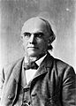
Dr. David S. Burbank
-
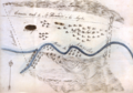
The Jonathan R. Scott tract, forming eastern Burbank along San Fernando Boulevard, called here the "Camino Real".
-
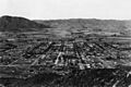
Burbank, 1922


See also
 In Spanish: Burbank para niños
