
Chicago metropolitan area facts for kids
Quick facts for kids
Chicago metropolitan area
|
|
|---|---|
| Chicago–Naperville, IL–IN–WI Combined Statistical Area |
|
|
From top, left to right: Chicago skyline from Lakefront Trail at Northerly Island during sunrise, aerial view Evanston, view of Gold Coast, Downtown Naperville, view of Downtown Aurora
|
|
| Country | |
| State | |
| Core city | |
| Satellite cities |
|
| Area | |
| • Metro | 10,856 sq mi (28,120 km2) |
| Highest elevation | 673 ft (205 m) |
| Lowest elevation | 579 ft (176 m) |
| Population | |
| • Density | 886/sq mi (342/km2) |
| • Metropolitan Statistical Area (MSA) (2022) | 9,441,957 (3rd) |
| • Combined Statistical Area (CSA) (2022) | 9,806,184 (4th) |
| Demonym(s) | Chicagolander |
| GDP | |
| • MSA | $832.900 billion (2022) |
| • CSA | $855.679 billion (2022) |
| Time zone | UTC−6 (CST) |
| • Summer (DST) | UTC−5 (CDT) |
| Area codes | 219, 224/847, 262, 312/872, 331/630, 574, 464/708, 773/872 and 779/815 |


.jpg)


The Chicago metropolitan area, also known as Chicagoland, is a huge area around the city of Chicago. It's the largest metropolitan area in Illinois and the entire Midwest. This area includes Chicago, its many suburbs, and other nearby cities.
Chicagoland covers about 10,286 square miles (28,120 km²). It stretches across 14 counties in parts of Illinois, Indiana, and Wisconsin. In 2020, about 9.6 million people lived in the main Chicago metropolitan area. If you include even more surrounding counties, the total population is almost 10 million!
This makes the Chicago area the third largest metropolitan area in the United States. It's also the fourth largest in North America, after Mexico City, New York City, and Los Angeles. It's the biggest urban area in the Great Lakes megalopolis, a chain of large cities around the Great Lakes.
Chicagoland is home to many different groups of people. The population includes large numbers of people with European, African, Latino, Asian, and Arab backgrounds. There are also Native American residents. This makes the Chicago metropolitan area very diverse. About 3% of the entire U.S. population lives here.
The Chicago area has one of the world's biggest and most varied economies. Over six million people work here. Chicagoland is very important to Illinois's economy, helping the state make over $1 trillion each year. In 2018, the region itself produced about $700 billion in goods and services.
Many big companies have their main offices in Chicagoland. More than 400 major companies are based here, including 31 of the top 500 companies in the U.S. (like McDonald's and United Airlines). For nine years in a row, the Chicago area was the top place in the country for companies to move to or expand.
You'll find many top research universities in the Chicago area. These include the University of Chicago, Northwestern University, and the University of Illinois at Chicago. The University of Chicago and Northwestern University are often ranked among the best universities in the world.
Getting around Chicagoland is easy with many transportation choices. There are three main train networks: the Chicago Transit Authority (CTA), Metra, and the South Shore Line. The CTA runs elevated and subway trains mostly within Chicago and some nearby suburbs. Some CTA trains run 24 hours a day, every day! This makes Chicago one of only a few cities in the world with nonstop train service.
The Metra commuter rail connects Downtown Chicago with many suburbs and even reaches Kenosha, Wisconsin. The interurban South Shore Line links Downtown Chicago with northwest Indiana. Amtrak also uses Union Station in Downtown Chicago as a major train hub, with lines going all over the country.
CTA buses serve Chicago, and Pace buses serve the suburbs. Many CTA bus routes also run 24 hours a day.
Contents
- Understanding Chicagoland: What Does It Mean?
- Geography and Environment: Exploring Chicago's Landscape
- People and Population: Who Lives in Chicagoland?
- Economy: How Chicagoland Makes Money
- Transportation: Getting Around Chicagoland
- Culture and Fun: What to Do in Chicagoland
- Education: Learning in Chicagoland
- Area Codes: Phone Numbers in Chicagoland
- Images for kids
- See also
Understanding Chicagoland: What Does It Mean?
Different Ways to Define the Chicago Area
The Chicago area can be described in a few ways, depending on how you measure it. These definitions help us understand how many people live here and how big the area is.
The main way is the Metropolitan Statistical Area (MSA). This is a region with a large city and its surrounding areas that are closely connected. The Chicago MSA is officially called the Chicago–Naperville–Elgin, IL–IN–WI Metropolitan Statistical Area. It's the third largest MSA in the U.S. In 2022, about 9.4 million people lived here.
A larger area is called the Combined Statistical Area (CSA). This includes the main MSA plus other nearby smaller metropolitan and micropolitan areas that are still connected. The Chicago–Naperville, IL–IN–WI Combined Statistical Area had about 9.8 million people in 2022.
The United Nations also has a way to define the "urban agglomeration" of Chicago. This term means the population living in the continuously built-up area, like the city and its connected urban parts. In 2023, this number was about 8.9 million people.
What is Chicagoland?


Chicagoland is a popular, informal name for the Chicago metropolitan area. It doesn't have one official definition, but it usually includes areas even beyond the main MSA.
Many people say that Colonel Robert R. McCormick, a newspaper editor, made the term popular. He used it in the Chicago Tribune newspaper in 1926. He thought Chicagoland included everything within about 200 miles (320 km) of Chicago.
Today, the Chicago Tribune usually defines Chicagoland as the city of Chicago, the rest of Cook County, and eight other nearby counties in Illinois. It also includes two counties in Indiana. Other groups, like the Chicagoland Chamber of Commerce, have slightly different definitions.
The "Collar Counties"
The term "collar counties" is a common nickname for five counties in Illinois that border Chicago's Cook County. These counties are DuPage, Kane, Lake, McHenry, and Will. They are the next five largest counties in Illinois after Cook County.
Geography and Environment: Exploring Chicago's Landscape
The city of Chicago is located on the Chicago Plain. This is a very flat and wide area with not many hills. Any small hills you see are usually sand ridges. North of the city, along Lake Michigan, there are steep cliffs and deep valleys.
Along the southern shore of the Chicago Plain, you can find sand dunes next to the lake. The tallest of these dunes can reach almost 200 feet (61 meters) high. They are located in Indiana Dunes National Park. Around the flat plain, especially in the south and west suburbs, there are bands of hills called moraines. These areas are higher and more hilly than the Chicago Plain.
A continental divide runs through the Chicago area. This is a high point that separates water flowing to the Mississippi River from water flowing to the Great Lakes and Saint Lawrence River.
In 2012, a study looked at the trees and forests in the seven Illinois counties of the Chicago area. It found that 21% of the land is covered by trees and shrubs. There are about 157 million trees! These trees help store carbon, recycle water, and save energy.

People and Population: Who Lives in Chicagoland?

In 2022, the Chicago metropolitan area had a population of about 9.4 million people. This means there were about 1,312 people living in every square mile.
The people living in Chicagoland come from many different backgrounds. In 2022, about half of the population was non-Hispanic White. Other large groups included Hispanic (23.4%), non-Hispanic African Americans (15.5%), and Asian (7.2%). This mix of cultures makes the area very vibrant.
The suburbs around Chicago have been growing very quickly since the 1960s. Cities like Aurora, Elgin, Joliet, and Naperville have seen huge growth. Kendall County, a county outside the main city, was one of the fastest-growing counties in the U.S. between 2000 and 2007.
Generally, the northern and northwestern suburbs are wealthier. The southern suburbs often have lower average incomes and a lower cost of living. However, the southwest suburbs also have many wealthy areas. DuPage County, for example, had the highest average household income of any county in the Midwest in 2000.
In 2022, the poverty rates in the largest counties varied. McHenry County had the lowest poverty rate at 4.0%, while Cook County had the highest at 13.6%. Cook County also has some of the most expensive homes in the region, especially in Chicago's luxury high-rises and along the waterfront in the North Shore.
Historically, many settlements around Chicago started as farm towns, industrial towns, or places where people lived and commuted by train. Even though these different types of towns sometimes had disagreements, they also worked together on things like building high schools.
Economy: How Chicagoland Makes Money

The Chicago metropolitan area is a major economic hub. It's home to the main offices of 57 companies that are on the Fortune 1000 list. These include well-known names like McDonald's, United Airlines, and Walgreens. Many global financial companies, such as Citadel LLC and Discover Financial Services, are also based here.
Chicago has the world's largest futures exchange, called the Chicago Mercantile Exchange. This is where people buy and sell contracts for future delivery of goods or financial products.
For many years, a key part of Chicago's economy was the Union Stock Yards. From 1865 to 1971, millions of cattle and hogs were processed here. This led poet Carl Sandburg to call Chicago the "Hog Butcher for the World."
Over time, the Chicago area started producing other things like telecommunications equipment, electronics, steel, and cars. By the early 2000s, Illinois's economy shifted more towards high-value services. These include financial trading, higher education, logistics (managing how things are moved), and health care. For example, the Chicago Mercantile Exchange, which now trades global financial products, started as a market for agricultural products.
The Chicago area has been very successful in attracting new businesses. In 2007, it was ranked first among U.S. metro areas for new and expanded company facilities. The Wall Street Journal once said that Chicago's economy has "survived by repeatedly reinventing itself."
Transportation: Getting Around Chicagoland


Chicagoland has a huge transportation network. This includes major airports, busy ports, and an extensive system of trains, buses, and highways.
Major Airports for Travel
- Chicago O'Hare International Airport (ORD)
- Chicago Midway International Airport (MDW)
- Milwaukee Mitchell International Airport (MKE) (near Milwaukee)
- Chicago Rockford International Airport (RFD) (near Rockford)
- Gary/Chicago International Airport (GYY)
Commercial Ports for Goods
- Port of Chicago
- Port of Indiana-Burns Harbor
Train and Bus Services
- The Chicago Transit Authority (CTA) runs trains, known as "the 'L'", and buses. These serve Chicago and its closest suburbs.
- Pace Suburban Bus operates bus routes in the suburbs.
- Metra commuter trains connect Downtown Chicago to many suburbs, including some in Wisconsin.
- The South Shore Line connects Chicago to northwest Indiana.
- Amtrak uses Union Station in Downtown Chicago as a major hub for long-distance passenger trains.
Major Highways for Driving
Chicagoland has many important highways, including several Interstates and U.S. Routes. These roads help people travel across the large metropolitan area. Some of the main ones include:
- I-55 (Adlai Stevenson Expy)
- I-90 (Jane Addams Tollway, Kennedy Expy, Dan Ryan Expy, Chicago Skyway)
- I-94 (Tri-State Tollway, Edens Expy, Kennedy Expy, Dan Ryan Expy)
- I-290 (Dwight D. Eisenhower Expy)
- I-294 (Tri-State Tollway)
Culture and Fun: What to Do in Chicagoland
Sports Teams in the Area
Chicagoland is home to many professional sports teams that play in major leagues:
- Major League Baseball (MLB): Chicago Cubs and Chicago White Sox
- National Football League (NFL): Chicago Bears
- National Basketball Association (NBA): Chicago Bulls
- National Hockey League (NHL): Chicago Blackhawks
- Major League Soccer (MLS): Chicago Fire
There are also many other professional teams, like the Chicago Sky (WNBA) and the Chicago Wolves (AHL). The Chicagoland Speedway hosts car races, and the Chicago Marathon is a famous running event.
Famous Chicago Foods
The Chicago area is known for some unique and delicious foods:
- Chicago-style hot dog: A hot dog with specific toppings like mustard, onions, relish, pickles, tomatoes, and celery salt.
- Chicago-style pizza: Often a deep-dish pizza with a thick crust and lots of cheese and toppings.
- Italian beef: Thinly sliced roast beef served on a long roll, often dipped in gravy.
- Caramel popcorn: A sweet and crunchy snack.
Media and News
The two main newspapers in Chicago are the Chicago Tribune and the Chicago Sun-Times. There are also many local TV channels and radio stations that serve the Chicago area, keeping everyone informed and entertained.
Education: Learning in Chicagoland

The Chicago metropolitan area has many different school districts for elementary and high school students. The largest is the Chicago Public Schools, which teaches about 400,000 students. There are also many private and religious schools, plus a growing number of charter schools.
Sometimes, there are differences in education quality between schools in Chicago and those in some suburbs.
Historically, the Chicago area has been important for new ideas in education. For example, Joliet Junior College is the oldest continuously running junior college in the U.S. The University of Chicago also played a big role in the "Great Books" movement, which focused on reading important classic texts.
Area Codes: Phone Numbers in Chicagoland
The Chicago metro area uses several different area codes for phone numbers. This helps manage the huge number of phones in the region.
- 312: Used for the central part of Chicago, like the Loop.
- 773: Used for the rest of Chicago, outside the central area.
- 872: An overlay for 312 and 773, meaning new numbers in those areas might start with 872.
- 847/224: For the North and Northwest Suburbs.
- 630/331: For the Outer Western Suburbs.
- 708: For the South and Near West Suburbs.
- 815/779: For areas like Rockford and Joliet, which are farther out.
- 219: For Northwest Indiana.
- 262: For Southeast Wisconsin, around Milwaukee.
New overlay codes are planned for the future as more phone numbers are needed.
Images for kids
-
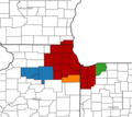
The Chicago–Naperville, IL–IN–WI Combined Statistical Area as defined by the U.S. Office of Management and Budget.

See also
 In Spanish: Área metropolitana de Chicago para niños
