Dinosaur Diamond Prehistoric Highway facts for kids
Quick facts for kids
[[File:|x70px|alt= marker]] Dinosaur Diamond Prehistoric Highway |
|
|---|---|
 |
|
| Route information | |
| Length | 512 mi (824 km) |
| Existed | 2002–present |
| Component highways |
|
| Major junctions | |
| West end | Price, Utah |
| East end | Grand Junction, Colorado |
| Location | |
| States: | Utah, Colorado |
| Counties: | Utah: Carbon, Duchesne, Grand, Emery Colorado: Moffat, Rio Blanco, Garfield, Mesa |
| Highway system | |
The Dinosaur Diamond Prehistoric Highway is a super cool road trip! It's also called the Dinosaur Diamond Scenic Byway. This special road is about 512 miles (824 km) long. It goes through the states of Utah and Colorado in the USA.
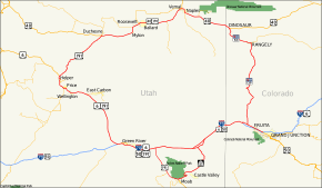
Imagine a giant diamond shape on a map. That's what this highway looks like! Its four main corners are Moab, Helper, Vernal, and Grand Junction.
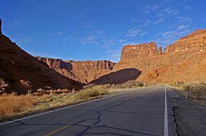
In Utah, this road is known as the Dinosaur Diamond Prehistoric Highway. In Colorado, it's called the Dinosaur Diamond Scenic and Historic Byway. Along this amazing route, you can find places like Dinosaur National Monument. You can also see Flaming Gorge National Recreation Area and famous national parks. These include Canyonlands National Park and Arches National Park. There are also many national forests to explore!
Exploring the Dinosaur Diamond
This special highway takes you on a journey through time. You'll see incredible landscapes and learn about ancient dinosaurs. It's a perfect adventure for anyone who loves history and nature!
Colorado Adventures
The Colorado part of the Dinosaur Diamond Byway includes several highways. These are I-70, US 40, CO 64, and CO 139.
The eastern starting point of the Dinosaur Diamond is in Grand Junction, Colorado. Near Grand Junction, you can find the White River National Forest, Uncompahgre National Forest, and Grand Mesa National Forest. These are great places for outdoor fun. You can also see cool rock formations like the Book Cliffs and Grand Mesa.
Fruita and Its Fun Facts
If you travel about 10 miles (16 km) west on I-70, you'll reach Fruita. This small town is close to the Colorado National Monument. This monument has many beautiful hiking trails. From these trails, you can see amazing sights. Look for the Book Cliffs and unique rock shapes like Independence Monument.
Fruita is also famous for something funny: Mike the Headless Chicken! Mike was a chicken who lived for 18 months without his head. Every May, Fruita hosts a festival to celebrate him. You can even see a small statue of Mike in town!
Rangely and Ancient Art
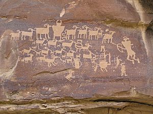
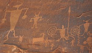
Just west of Fruita, the byway turns north onto SH-139. You'll drive about 78 miles (126 km) to Rangely. Along the way, you'll cross Douglas Pass. In Rangely, you can visit the Rangely Outdoor Museum. You can also see the Cañon Pintado ("painted canyon") Historic District. This area has ancient petroglyphs, which are pictures carved into rocks by early people. It's a truly historic spot!
Dinosaur National Monument: A Bone Bonanza
The byway continues about 18 miles (29 km) northwest on SH-64 to the town of Dinosaur. Near this town is the "crown jewel" of the Dinosaur Diamond: Dinosaur National Monument. This monument is known as the best place in the world to find Jurassic Period dinosaur bones!
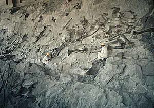
Inside the monument, there's a special walkway. Visitors can see a huge sandstone wall with over 2,000 dinosaur bones stuck in it. You can even watch paleontologists (scientists who study fossils) carefully chip away rock to find more fossils. There's also a lab where they clean and preserve the dinosaur fossils. It's like stepping back in time!
After leaving Dinosaur, the byway continues west on US 40 and crosses into Utah.
Utah Wonders
The Utah part of the Dinosaur Diamond Prehistoric Highway follows several routes. These include I-70, US 6, US 40, US 191, and UT 128.
Vernal and Its Surroundings
About 34 miles (55 km) west of Dinosaur, Colorado, you'll arrive in Vernal, Utah. Vernal is right next to the western part of Dinosaur National Monument. Other cool places nearby include Steinaker State Park, Red Fleet State Park, and Flaming Gorge National Recreation Area. The Ashley National Forest is also close by.
Roosevelt, Duchesne, and High Peaks
From Vernal, US 40 and US 191 go west together for about 30 miles (48 km) to Roosevelt. Roosevelt is on the edge of the Uintah and Ouray Indian Reservation. Another 29 miles (47 km) west is Duchesne.
Near Duchesne, you can find Starvation State Park. You can also see Kings Peak, which is the highest point in Utah! Kings Peak is part of the Uinta Mountains. These mountains are special because they are one of the few ranges in the United States that run east to west.
Price: More Dinosaurs and Ancient Art
In Duchesne, US 40 and US 191 split up. The Dinosaur Diamond continues about 55 miles (89 km) south along US 191. You'll pass through the small town of Helper and reach the city of Price.
Price has many attractions. You can visit the College of Eastern Utah Prehistoric Museum. It's full of amazing prehistoric finds! Nearby are the Manti-La Sal National Forest and Huntington Lake State Park.
Also close to Price is the Cleveland-Lloyd Dinosaur Quarry. This place was a prehistoric mud trap. It has the most dinosaur fossils from the Jurassic Period found anywhere in the world! You can also visit Ninemile Canyon, which has many ancient petroglyphs.
Green River and Moab's Natural Wonders
Traveling about 63 miles (101 km) southeast on US 191, you'll come to Green River. Here, you can explore the San Rafael Swell, Green River State Park, and Goblin Valley State Park. Goblin Valley is famous for its strange, mushroom-shaped rock formations!
Near Green River, you can also see Crystal Geyser. This is a rare cold-water geyser. It's actually man-made, caused by gas expanding underground.
From Green River, US 191 continues south for about 55 miles (89 km) to Moab. Moab is a hub for outdoor adventures. It's near Arches National Park and Canyonlands National Park. These parks have incredible natural arches and canyons. You can also visit Dead Horse Point State Park. Don't miss the Newspaper Rock and Potash Road petroglyphs near Moab!
Leaving Moab, the byway goes north on SR-128. It ends at I-70 in Cisco. From there, you travel east on I-70 to complete the "diamond" loop back to Grand Junction, Colorado.
History of the Byway
The Dinosaur Diamond is a relatively new special highway. The part in Colorado was named the Dinosaur Diamond Scenic and Historic Byway in 1997. The Utah part was named the Dinosaur Diamond Prehistoric Highway in 1998.
In 2002, the entire highway was officially approved as a National Scenic Byway. To become a National Scenic Byway, a road must be very special. It needs to show at least one of six "intrinsic qualities." These qualities can be scenic beauty, natural features, history, culture, archaeology, or recreation. The Dinosaur Diamond clearly has many of these!
Early Roads in Colorado
Before I-70 was built in Colorado, two older highways, US 6 and US 40, followed a similar path. US 40 was one of the very first U.S. Highways, created in 1926. The part that became US 6 was paved in 1937.
Utah's Old Trails
The very first route through this part of Utah was the Old Spanish Trail. This was a trade route used before 1848. It connected Santa Fe, New Mexico with Los Angeles. Even though I-70 doesn't follow the exact same path, both routes aimed to connect California with places further east.
Over the years, different parts of the Dinosaur Diamond route became state highways. For example, a road connecting Colton with Duchesne became a state highway in 1910. It later became part of US 191.
Getting to Moab used to be very hard! There was a steep "pack trail" called the Heavenly Stairway. It was beautiful but tough to use. People in Moab needed a better road to connect with other cities. By 1902, a toll road called King's Toll Road was built. Even though it was better, it often flooded. Today, the modern highways make exploring this amazing area much easier!
Images for kids
-
Independence Monument in Colorado National Monument
-
Steamboat Rock in Dinosaur National Monument
 | Emma Amos |
 | Edward Mitchell Bannister |
 | Larry D. Alexander |
 | Ernie Barnes |


