
Gibraltar facts for kids
Quick facts for kids
Gibraltar
|
|
|---|---|
 Flag
 Coat of arms
|
|

Location of Gibraltar (dark green)
– on the European continent (green & dark grey) |
|

Map of Gibraltar
|
|
| Status | British Overseas Territory |
| Capital | Gibraltar 36°8′N 5°21′W / 36.133°N 5.350°W |
| Largest district (by population) |
Westside |
| Official languages | English |
| Spoken languages | |
| Ethnic groups |
|
| Demonym(s) | Gibraltarian Llanito (colloquial) |
| Government | Representative democratic parliamentary dependency under constitutional monarchy |
|
• Monarch
|
Elizabeth II |
|
• Governor
|
Ed Davis |
|
• Chief Minister
|
Fabian Picardo |
| Legislature | Parliament |
| Formation | |
|
• Captured
|
4 August 1704 |
|
• Ceded
|
11 April 1713 |
|
• National Day
|
10 September 1967 |
|
• Joined the EEC
|
1 January 1973 |
| Area | |
|
• Total
|
6.7 km2 (2.6 sq mi) |
|
• Water (%)
|
0 |
| Population | |
|
• 2015 estimate
|
32,194 (222nd) |
|
• Density
|
4,328/km2 (11,209.5/sq mi) (5th) |
| GDP (PPP) | 2013 estimate |
|
• Total
|
£1.64 billion |
|
• Per capita
|
£50,941 (n/a) |
| HDI (2015) | 0.961 very high · 5th |
| Currency | Gibraltar pound (£) (GIP) |
| Time zone | UTC+1 (CET) |
|
• Summer (DST)
|
UTC+2 (CEST) |
| Date format | dd/mm/yyyy |
| Driving side | right |
| Calling code | +350 |
| ISO 3166 code | GI |
| Internet TLD | .gi |
|
|

Gibraltar is an Overseas Territory of the United Kingdom. This means it shares the British King or Queen and has the protection of the British Armed Forces. It is located in southwest Europe on the Mediterranean Sea. About 32,000 people live there, and they are called Gibraltarians.
Gibraltar has always been important as a military base. This is because the Mediterranean Sea narrows to only 14 kilometres (9 miles) at the Strait of Gibraltar here. The country that controlled Gibraltar could see all ships entering the Mediterranean Sea.
Gibraltar is most famous for The Rock of Gibraltar. This is a 426-meter high limestone rock that rises out of the sea. The Rock can be seen from many miles away. It is home to the Barbary Apes, which are a type of tail-less macaque. They are the only wild monkeys found in Europe.
Contents
Gibraltar's History
Gibraltar was named after a general who led the Umayyad conquest of Hispania. It belonged to Spain from 1501 to 1704. A group of Dutch and British marines captured it during the War of the Spanish Succession in 1704.
In 1713, Spain signed the Treaty of Utrecht. This treaty ended the war and stated that Gibraltar would be British forever. However, the treaty also said that if Great Britain ever wanted to leave the territory, Spain would have the first chance to claim it back.
Since then, Spain has tried to get Gibraltar back. They attacked the Rock many times in the 18th century. Since the 1950s, Spain has tried to get Gibraltar back through diplomacy. This means using international talks and putting pressure on the people of Gibraltar.
Gibraltar in World War II
Gibraltar was very important during World War II. Its location made it a perfect base for the British army and navy. During the war, people living in Gibraltar were moved to places like Jamaica. This was to keep them safe and to free up space for soldiers.
The Rock of Gibraltar was used by these soldiers. Long tunnels were built inside it. These tunnels even had a hospital and living areas for the soldiers.
Self-Government and Voting
In 1969, Britain gave Gibraltar a new constitution. This meant that the people of Gibraltar gained a lot of self-government. They could make many of their own decisions.
In 2002, the people of Gibraltar were asked to vote on whether they wanted Spain to share Gibraltar with the United Kingdom. Almost everyone voted, and 98.97% said they did not want to share.
In 2006, Gibraltar approved a new constitution. This gave the people full self-government, meaning they could create their own laws independently. Also in 2006, Spain agreed to stop interfering with Gibraltar's telephone lines. Daily flights between Gibraltar and Madrid also started.
Geography of Gibraltar


Gibraltar's land area is about 6.7 square kilometres (2.6 sq mi). It shares a 1.2 kilometre (0.75 mi) land border with Spain. The Spanish town of La Línea de la Concepción is right next to the border. The area around Gibraltar in Spain is called Campo de Gibraltar.
The shoreline of Gibraltar is 12 kilometres (7.5 mi) long. Gibraltar has two main coasts or "Sides." The East Side has the small towns of Sandy Bay and Catalan Bay. The Westside is where most of the people live. Gibraltar has no official administrative divisions. Instead, it is divided into seven Major Residential Areas.
Water Resources
Gibraltar does not have many natural resources or much natural freshwater. Until recently, it used large concrete or natural rock areas to collect rainwater. Today, fresh water from underground wells is also used. Two desalination plants help provide water. One uses reverse osmosis and is built inside a tunnel in the Rock. The other uses multi-stage flash distillation and is located at North Mole.
The Rock's Terrain
Gibraltar's land is mostly the 426-meter (1,398 ft) high Rock of Gibraltar. This Rock is made of Jurassic limestone. There is also a narrow flat area along the coast. The Rock contains many tunnels, which are mostly still used by the military and are closed to the public.
 |
|
|||
| Mediterranean Sea | ||||
| Strait of Gibraltar; |

Climate in Gibraltar
Gibraltar has a Mediterranean climate. This means it has mild, rainy winters and warm, dry summers. The average daily high temperature is about 22°C (72°F). The average overnight low is about 15°C (59°F).
In January, the coldest month, the high temperature averages 16.3°C (61.3°F). The overnight low is 11°C (52°F). The average sea temperature is 16°C (61°F). In August, the warmest month, the daily high temperature is 25°C (77°F). The overnight low is 20°C (68°F), and the average sea temperature is 22°C (72°F).
Plants and Animals


Over 500 different types of flowering plants grow on the Rock. Gibraltar is the only place in Europe where the Gibraltar candytuft (Iberis gibraltarica) grows wild. This plant is usually found in North Africa. It is a symbol of the Upper Rock nature reserve. Olive and pine trees are also common around the Rock.
Most of the upper part of the Rock is a nature reserve. It is home to about 230 Barbary macaques. These are the famous "apes" of Gibraltar, but they are actually monkeys. They are the only wild monkeys found in Europe. This species is considered endangered and its numbers are decreasing. Three-quarters of the world's population live in the Middle Atlas mountains of Morocco.
Other mammals in Gibraltar include rabbits, foxes, and bats. Dolphins and whales are often seen in the Bay of Gibraltar. Many migrating birds visit Gibraltar. It is also home to the only Barbary partridges found on the European continent.
Environment and Air Quality

In May 2016, a report by the World Health Organization showed that Gibraltar had some air quality challenges. The report focused on tiny particles in the air called PM10 and PM2.5 pollutants.
Gibraltar's Economy

Gibraltar's economy today relies on four main areas. These are financial services, online gambling, shipping, and tourism. Tourism includes selling duty-free goods to visitors. The territory also has a small manufacturing sector. One company makes ambulances from converted SUV vehicles for the United Nations.
Tourism is a very important industry. Gibraltar is a popular stop for cruise ships. It also attracts day visitors from resorts in Spain. The Rock is a popular tourist spot, especially for British tourists.
The currency used in Gibraltar is the Gibraltar pound.
Population and Languages
Gibraltar is one of the most densely populated places in the world. In 2012, about 32,194 people lived there. This means there were about 4,959 people per square kilometre (12,840 per sq mi). To create more space, new land is often made by filling in parts of the sea. This reclaimed land now makes up about one-tenth of Gibraltar's total area.
Languages Spoken
The official language of Gibraltar is English. It is used by the government and in schools. Most local people can speak two languages, usually English and Spanish. Because many different groups live there, other languages are also spoken.
Berber and Arabic are spoken by the Moroccan community. Hindi and Sindhi are spoken by the Indian community. Some families of Maltese descent also speak Maltese.
Getting Around Gibraltar

The main way people get around Gibraltar is by car. Motorcycles are also very popular. There is also a good modern bus service. Unlike in the UK, traffic drives on the right side of the road. Speed limits are in kilometres per hour (km/h). This is because Gibraltar shares a land border with Spain. The E15 highway connects Spain, France, and the United Kingdom. You can reach it from the Spanish side using the CA-34 highway.
There is a Gibraltar Cable Car that takes people from the ground to the top of the Rock. It has a stop in the middle at Apes' Den.
Images for kids
-
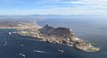
An aerial view
-
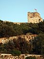
View of the northern face of the Moorish Castle's Tower of Homage
-
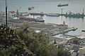
Buildings of the former HM Dockyard, Gibraltar, dating from the 1895 expansion
-
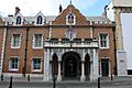
Main Street entrance to the Governor's Residence, The Convent
-
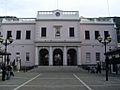
John Mackintosh Square entrance to the Gibraltar Parliament
-
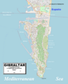
Enlargeable, detailed map of Gibraltar
-
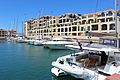
Queensway Quay Marina, along with Ocean Village, are two exclusive residential districts.
-
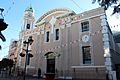
The Roman Catholic Cathedral of St. Mary the Crowned was built in 1462 and is the territory's oldest Catholic church.
-
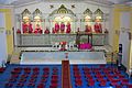
The Gibraltar Hindu Temple opened in 2000.
-
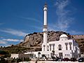
The Ibrahim-al-Ibrahim Mosque was a gift from King Fahd of Saudi Arabia.
-
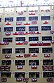
Tercentenary celebrations in Gibraltar
-
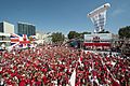
Thousands of Gibraltarians dress in their national colours of red and white during the 2013 Gibraltar National Day celebrations.
-

The Gibraltar national football team lining up in their first official match, against Slovakia, in 2013
-
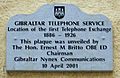
A plaque in City Mill Lane marking the site of Gibraltar's first telephone exchange
-
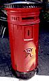
A Victorian post box of standard 1887 UK design in use in Gibraltar's Main Street (2008)
-
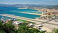
The main road that crosses Gibraltar Airport
-
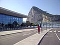
The new terminal at Gibraltar Airport
-
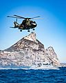
Merlin HC3 of 846 NAS with HMS Scimitar
-
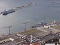
The Royal Navy's base in Gibraltar


_(2).jpg)


See also
 In Spanish: Gibraltar para niños
