
Harrison County, Indiana facts for kids
Quick facts for kids
Harrison County
|
|
|---|---|

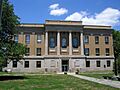
Harrison County courthouse in Corydon, built in 1928
|
|

Location within the U.S. state of Indiana
|
|
 Indiana's location within the U.S. |
|
| Country | |
| State | |
| Founded | December 1, 1808 |
| Named for | William Henry Harrison |
| Seat | Corydon |
| Largest city | Corydon |
| Area | |
| • Total | 486.52 sq mi (1,260.1 km2) |
| • Land | 484.52 sq mi (1,254.9 km2) |
| • Water | 2.00 sq mi (5.2 km2) 0.41%% |
| Population
(2020)
|
|
| • Total | 39,654 |
| • Estimate
(2023)
|
40,006 |
| • Density | 81.5054/sq mi (31.4694/km2) |
| Time zone | UTC−5 (Eastern) |
| • Summer (DST) | UTC−4 (EDT) |
| Congressional district | 9th |
| Indiana county #31 Fourth oldest county in state FIPS Code 061 |
|
Harrison County is a place in southern Indiana, right next to the Ohio River. It was officially started in 1808. In 2020, about 39,654 people lived there. The main town, called the county seat, is Corydon. This town used to be the capital of Indiana!
Harrison County has many different types of jobs. No single job type employs a huge part of the people. Big employers include Caesars Southern Indiana (a casino), Tyson Foods (a food company), and the Harrison County Hospital. Many people also visit the county because it has lots of cool historic places.
The county government has different parts. There are elected commissioners who make laws and lead. An elected county council manages the money. There are also courts and local leaders in each of the 12 townships. Harrison County has 10 towns with their own governments and many smaller communities. Major roads and two train lines also run through the county.
Long ago, Native American groups lived here for thousands of years. The first European settlers came to Harrison County after the American Revolutionary War. The number of people living here grew very fast in the early 1800s. Corydon became the capital of the Indiana Territory in 1813. Many important events happened here, like writing Indiana's first constitution. Corydon was the state capital until 1825. Even after that, it stayed an important center for southern Indiana. In 1859, a large meteorite fell here. In 1863, the Battle of Corydon happened. This was the only battle of the American Civil War fought in Indiana.
Contents
History of Harrison County
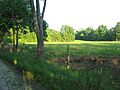
Humans first came to this area when the last ice age was ending. This place was special because it had a lot of flint. Flint is a type of stone. People mined flint in caves here as early as 2000 BCE. They used it to make tools. Different groups of people, like the Hopewells and Mississippians, traveled through this area. One important place where people worked with flint is the Swan's Landing Archeological Site. It's one of the most important old sites in eastern North America. People started living here permanently in the late 1700s.

The United States took control of this area after the American Revolutionary War. Soldiers who fought in the war received land here. Daniel Boone and his brother Squire Boone explored the county in the 1780s. Some of the first settlers, like Harvey Heth, Spier Spencer, and Edward Smith, arrived in the 1790s. Edward Smith built the first house near where Corydon is today.
How Harrison County Was Formed
Harrison County was originally part of Knox County and Clark County. It became its own county in 1808. It was the first county created by the Indiana territorial lawmakers, not just the Governor. It was the fourth county formed in what would become Indiana. Later, parts of Harrison County were used to create other counties like Crawford, Floyd, and Washington. The county was named after William Henry Harrison. He was the first governor of the Indiana Territory. He was also a general in the War of 1812 and later the 9th U.S. President. Harrison owned a lot of land in the county and had a small home at Harrison Spring.
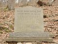
Squire Boone moved to the area in 1806. He died in 1815 and is buried in a cave near his home, called Squire Boone Caverns. Other members of the Boone family also settled in Harrison County. The county's first church, called Old Goshen, was built by Boone. Paul and Susannah Mitchem, who were Quakers, moved to Harrison County in 1814. They brought 107 enslaved people with them and freed them when they arrived. This group became one of the largest communities of free Black people in Indiana.

Early Roads and Growth
The first road in Harrison County was built in 1809. It connected Corydon to Mauckport on the Ohio River. A ferry service at Mauckport brought settlers from Kentucky. This road and ferry made it much easier for people to come to the county. This helped the area grow quickly. The county's population more than doubled in the next ten years.
Dennis Pennington, a leader from near Lanesville, became important in the territory's government. Corydon began to compete with other towns to become the new capital. In 1813, the capital was moved to Corydon because it was thought to be safer. For the next twelve years, Corydon was the political center. Indiana's first constitution was written in Corydon in June 1816. After Indiana became a state in December 1816, Corydon was the state capital until 1825.
Changes to County Borders
The county was first divided in 1814 when Washington County was created from its northern part. In 1818, Crawford County was formed from the western part. In 1819, Floyd County was created from the eastern part. Since then, there have been only small changes to Harrison County's eastern border. The last change was in 1968.
The Barrens and a Meteorite
The northern part of the county was called the "barrens." Early settlers named it this because there were not many trees. Wildfires happened every year, which stopped trees from growing. The largest barren area stretched from Corydon north to Palmyra. As more people settled and farming grew, they found the barrens had good soil. They stopped the wildfires, and by the 1900s, the barrens became forests.
A large meteorite fell near Buena Vista on March 28, 1859. The place where it hit and a piece of the meteorite have been saved.
Fair and Civil War Battle
The first Harrison County fair was held in Corydon in 1860. It has happened every year since then. It is the longest-running fair in Indiana. The fairground was built on Edward Smith's old property.

The only American Civil War battle fought in Indiana happened in Harrison County. It was on July 9, 1863. A group of local soldiers, called the Harrison County Legion, fought against Confederate soldiers led by General John Hunt Morgan. Morgan's soldiers crossed the Ohio River into Harrison County. The local soldiers tried to stop them. The citizens of Mauckport ran away with their valuables. Morgan's soldiers landed and marched north, burning homes and farms. The county militia tried to block them near Corydon. This fight is known as the Battle of Corydon. The Confederates won the battle. Then, they took things from the town of Corydon. Four people died, 12 were hurt, and 355 were captured. After the battle, Morgan's forces continued to rob other towns in northern Harrison County. They left the county the next day. Later, they were defeated and captured by the Union Army.

Railroads and Courthouses
The railroad came to Harrison County in 1869. A train line was finished across the northern part of the county in 1874. It connected Crandall and went west into Crawford County. A line connecting Corydon to Crandall was finished in 1882. A train crash killed three people in 1902. The southern part of the line that went to Corydon was bought by a company in 1989. It was used for tourist rides until 2003, when passenger train service in the county ended.
The first county courthouse was a small building made of logs. When Corydon became the capital in 1813, county and territory leaders shared this building. By 1816, a stone building was built. It was both the Harrison County Courthouse and the state capital building until 1825. As more space was needed, other buildings were built. In the 1920s, an old office building was torn down to build a new courthouse. The old stone building was saved by the State of Indiana and is now known as the first state capitol building. The new courthouse was finished in 1928.
State Parks and Bridges
The Harrison-Crawford State Forest was started in 1932. The State of Indiana bought land in western Harrison County for it. This park is over 26,000 acres (105 square kilometers) and is the largest state forest in Indiana. It surrounds the O'Bannon Woods State Park and the Wyandotte Caves.

The Matthew E. Welsh Bridge was finished in 1966 in Mauckport. It connects Harrison County with Meade County in Kentucky. This is the only bridge over the Ohio River between Tell City and New Albany. In 1969, Samuel Hays gave 311 acres (1.26 square kilometers) of land to the county. This land became the Hayswood Nature Reserve. It was developed in 1973 with public areas. It is the second largest nature reserve in the county.
Caesars Indiana opened a casino, hotel, and golf course in 1998. This helped the county's tourism. The casino complex was later bought and became Horseshoe Southern Indiana in 2008.
Geography of Harrison County

Harrison County is in the very southern part of Indiana. It is about halfway between the state's east and west sides. The Ohio River forms the county's southern edge. Across the river is Kentucky and the city of Louisville. The Blue River forms most of the county's western border.
When settlers first arrived, the lower half of the county was covered in thick forests. Today, some parts are still wooded, but other areas are used for farming or towns. The land slopes down towards the south and west. The highest point is on Lagle Ridge, about 972 feet (296 meters) above sea level.
The western part of the county is drained by the Blue River, which flows south. The middle part is drained by Indian Creek, which flows southwest. The lower part of the county is drained by three branches of Indian Creek. There are only two large man-made lakes in the county: Lake Coleman in Buffalo Trace Park near Palmyra, and a lake formed by a dam on Buck Creek. There are also smaller water bodies, like Harrison Spring.
According to the 2010 United States Census, the county covers about 486.52 square miles (1,260.1 square kilometers). Most of this, about 484.52 square miles (1,254.9 square kilometers), is land. Only a small part, about 2.00 square miles (5.2 square kilometers), is water.
Harrison Spring is west of Corydon. It is 60 feet (18 meters) wide and over 40 feet (12 meters) deep. This makes it the largest and deepest spring in Indiana. It comes out of solid rock and used to be powerful enough to run flour mills. It produces over 3 million gallons (11 million liters) of water every day. It is named after William Henry Harrison, who owned this land.
Harrison County has some hilly areas. The Knobstone Escarpment starts in the southeastern part of the county. It rises sharply at the Ohio River and runs along the eastern edge. These "knobs" are the biggest hills in Indiana. The highest knobs near the Ohio River are about 610 feet (186 meters) higher than the valley around them. This is the biggest height difference in the state.
Even though the county was mostly forest before people settled here, there was a natural grassland (prairie) in the southern half. This was the most isolated prairie in Indiana. A small part of this original prairie, along with a larger restored area, is now part of O'Bannon Woods State Park. You can walk a 0.8-mile (1.3-kilometer) trail through the prairie.
The western part of the county is protected as the Harrison-Crawford State Forest and the O'Bannon Woods State Park. The county also has many large cave systems. These include Squire Boone Caverns, the Binkley Cave System (which includes Indiana Caverns), and smaller, beautiful caves like Jewel Box and Devil's Graveyard caves.
Neighboring Counties
- Washington County – north
- Floyd County – east
- Hardin County, Kentucky – southeast
- Jefferson County, Kentucky – east
- Meade County, Kentucky – southwest
- Crawford County – west
Towns and Communities
- Corydon (county seat)
- Crandall
- Elizabeth
- Laconia
- Lanesville
- Mauckport
- Milltown
- New Amsterdam
- New Middletown
- Palmyra
Smaller Communities (Unincorporated)
- Bradford
- Breckenridge
- Bridgeport
- Buena Vista
- Byrneville
- Central
- Central Barren
- Corydon Junction
- Davidson
- Depauw
- Dixie
- Dogwood
- Evans Landing
- Fairdale
- Fishtown
- Frenchtown
- Glidas
- Hancock Chapel
- Macedonia
- Moberly
- Mott
- New Boston
- New Salisbury
- Ramsey
- Rosewood
- Sugar Grove
- Titus
- Tobacco Landing
- Valley City
- White Cloud
Townships (Local Divisions)
- Blue River
- Boone
- Franklin
- Harrison
- Heth
- Jackson
- Morgan
- Posey
- Spencer
- Taylor
- Washington
- Webster
Ghost towns
Climate and Weather
| Weather chart for Corydon, Indiana | |||||||||||||||||||||||||||||||||||||||||||||||
|---|---|---|---|---|---|---|---|---|---|---|---|---|---|---|---|---|---|---|---|---|---|---|---|---|---|---|---|---|---|---|---|---|---|---|---|---|---|---|---|---|---|---|---|---|---|---|---|
| J | F | M | A | M | J | J | A | S | O | N | D | ||||||||||||||||||||||||||||||||||||
|
3.7
41
21
|
3.5
48
24
|
4.8
59
33
|
4.7
69
41
|
5.1
77
49
|
4.8
85
59
|
4.2
88
63
|
3.9
87
61
|
3.6
81
53
|
3.1
70
41
|
4.4
57
34
|
4
46
25
|
||||||||||||||||||||||||||||||||||||
| temperatures in °F precipitation totals in inches source: The Weather Channel |
|||||||||||||||||||||||||||||||||||||||||||||||
|
Metric conversion
|
|||||||||||||||||||||||||||||||||||||||||||||||
Harrison County has a humid subtropical climate. This means it has hot, humid summers and mild winters. The average temperatures in Corydon range from about 21°F (minus 6°C) in January to 88°F (31°C) in July. The coldest temperature ever recorded was minus 31°F (minus 35°C) in January 1977. The hottest was 104°F (40°C) in July 1983. The county gets about 3 to 5 inches (7.6 to 12.7 centimeters) of rain each month.
Population and People
| Historical population | |||
|---|---|---|---|
| Census | Pop. | %± | |
| 1810 | 3,595 | — | |
| 1820 | 7,875 | 119.1% | |
| 1830 | 10,273 | 30.5% | |
| 1840 | 12,459 | 21.3% | |
| 1850 | 15,286 | 22.7% | |
| 1860 | 18,521 | 21.2% | |
| 1870 | 19,913 | 7.5% | |
| 1880 | 21,326 | 7.1% | |
| 1890 | 20,786 | −2.5% | |
| 1900 | 21,702 | 4.4% | |
| 1910 | 20,232 | −6.8% | |
| 1920 | 18,656 | −7.8% | |
| 1930 | 17,254 | −7.5% | |
| 1940 | 17,106 | −0.9% | |
| 1950 | 17,858 | 4.4% | |
| 1960 | 19,207 | 7.6% | |
| 1970 | 20,423 | 6.3% | |
| 1980 | 27,276 | 33.6% | |
| 1990 | 29,890 | 9.6% | |
| 2000 | 34,325 | 14.8% | |
| 2010 | 39,364 | 14.7% | |
| 2020 | 39,654 | 0.7% | |
| 2023 (est.) | 40,006 | 1.6% | |
In 2020, there were 39,654 people living in Harrison County. Most people (92.5%) were White. Smaller groups included Black or African American (0.47%), Asian (0.48%), and Native American (0.2%). About 2.3% of the people were Hispanic or Latino.
In 2010, there were 15,192 households in the county. About 33.7% of these households had children under 18. The average age of people in the county was 40.2 years old. The average income for a household was $47,697. About 10% of the people in the county lived below the poverty line.
Economy of Harrison County

Harrison County has a strong and varied economy. Many factories are located in the Corydon Industrial Park. These often make parts for cars. There is also a lot of farming in the countryside. Corn and soybeans are the biggest crops grown here. Corydon is also a center for shopping and services. The county has several medical places, including the Harrison County Hospital.
Tourism is a big part of the economy. People visit the historic sites in Corydon. They also enjoy the county's golf courses. The Horseshoe Riverboat Casino and Hotel is a major attraction. The area's two famous caves, Squire Boone Caverns and Wyandotte Caves, also bring in visitors. The casino is the biggest source of tax money for the county.
Many companies provide services to the county. Electricity comes from the Harrison Rural Electric Membership Cooperative (REMC) and Duke Energy. Natural gas is provided by the Indiana Utilities Corporation in Corydon. Phone service is mainly from Verizon. Cable television is available in some areas. Water is supplied by several companies, like South Harrison Water Corporation.
As of 2009, the Horseshoe Southern Indiana casino was the largest employer, with 1,600 workers. Other big employers included Tyson Foods (550 workers) and Harrison County Hospital (504 workers). Many people work in retail (13%), government (12%), and manufacturing (12%).
Transportation in Harrison County
Roads and Highways
- Interstate 64 goes through Harrison County from east to west. It connects Corydon and Lanesville.
- US Route 150 crosses the northern part of the county. It follows an old path called the Buffalo Trace.
- State Road 135 runs north and south through the county.
- State Road 62 runs east and west. It crosses State Road 135 in Corydon.
- State Road 64 also runs east and west across northern Harrison County. It crosses State Road 135 in New Salisbury.
- State Road 111 connects Elizabeth to New Albany. The Horseshoe Riverboat Casino is on this road.
- State Road 337 runs diagonally across the county and goes through Corydon.
- State Road 211 is a short road east of Elizabeth.
- State Road 462 connects the Harrison-Crawford State Forest to State Road 62.
Train Lines
- Lucas Oil Rail Line is a 7-mile (11-kilometer) train line. It goes from Corydon north through an industrial park. It connects to the east-west Norfolk Southern Railway line near New Salisbury.
- The Norfolk Southern line crosses northern Harrison County. It goes through Crandall, Ramsey, and Depauw. It has a small station in Ramsey.
Airport
Harrison County has one airport for small planes. It is called Robinson Airpark and is located north-northwest of Elizabeth.
Education in Harrison County
The county has 22 schools. Fifteen are public schools in three different school districts. Seven are private schools. South Harrison Community Schools is the largest district. It covers the southern half of the county. It includes Corydon Central High School and several elementary schools. North Harrison Community School Corporation is another large district. Lanesville Community School Corporation is the smallest district.
In 2010, teachers in the North Harrison district earned about $50,800 per year. South Harrison teachers earned about $48,500. Lanesville teachers earned about $51,500. The graduation rates for high schools in 2010 were good. Lanesville and North Harrison students did better than average on statewide tests.
Several private schools are supported by local churches. St. John's is a Lutheran school near Lanesville. St. Joseph's is a Catholic school in Corydon. High school students can also go to the vocational school C. A. Prosser school of Technology in a neighboring county. This helps them learn job skills.
In 2017, the Lanesville Eagles baseball team won the school's first state championship. This was also the first state title for any sport in Harrison County history!
The Harrison County Public Library system serves the county. All residents can use the library for free.
Famous People from Harrison County

- William Taylor Zenor – Born in 1846 near Corydon. He was a lawyer and a judge. He represented Indiana in the U.S. House of Representatives from 1897 to 1907. He is buried in Corydon.
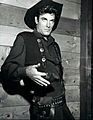
- James Best – Born in 1926 in Kentucky. He was adopted and grew up in Corydon. After serving in the Army, he became a movie and TV actor. He is best known for playing Sheriff Rosco P. Coltrane on The Dukes of Hazzard.
- Arville Funk – Born in Harrison County in 1929. He taught history and later became a lawyer in Corydon. He was very active in Indiana history groups and wrote many books about Indiana's past. He is buried in Corydon.
- Frank O'Bannon – Born in 1930 in Corydon. After serving in the Air Force, he became a state senator, lieutenant governor, and then governor of Indiana from 1997 to 2003. He is buried in Corydon.
Images for kids
-
Harrison County courthouse in Corydon, built in 1928
-
Swan's Landing Site
-
Original burial site marker of Squire Boone
-
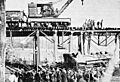
A train wreck at the Corydon Junction's southern trestle (January 19, 1902)
-
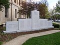
The Harrison County memorial to the county's war casualties
-
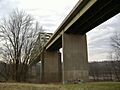
The Matthew E Welsh Bridge
-
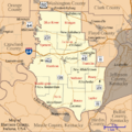
Map of Harrison County, showing townships, settlements, and major highways
-
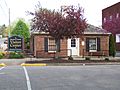
Harrison County Visitors Center
-
James Best
See also
 In Spanish: Condado de Harrison (Indiana) para niños
