
Hudson Waterfront facts for kids

Satellite image showing the inner core of the New York–New Jersey Harbor Estuary and main waterways of Port of New York and New Jersey. The Hudson Waterfront is situated on the peninsula between the Hudson and Hackensack Rivers, and their bays.
|
||||||||||||||||||||||||

The Hudson Waterfront is a busy urban area in northeastern New Jersey. It stretches along the lower part of the Hudson River, the Upper New York Bay, and the Kill van Kull. While "waterfront" usually means the shoreline, here it refers to a long, connected urban area. This area is about 19 miles (30 kilometers) long. It runs from the Bayonne Bridge to the George Washington Bridge. People sometimes call it the Gold Coast.
The Hudson Waterfront includes several towns and cities. In Hudson County, these are Bayonne, Jersey City, Hoboken, Union City, Weehawken, West New York, Guttenberg, and North Bergen. In Bergen County, it includes Fairview, Cliffside Park, Edgewater, and Fort Lee.
To the east, you'll find New York City boroughs like Manhattan and Brooklyn. To the south is Staten Island. To the west are Newark Bay and the New Jersey Meadowlands. To the north are the Northern Valley and the Palisades Interstate Park. A walking path called the Hudson River Waterfront Walkway runs along the Hudson River.
Long ago, during the Dutch colonial era, this area was part of New Amsterdam. It was known as Bergen. Today, Jersey City and Hoboken are sometimes called New York City's "sixth borough." This is because they are very close and connected by PATH trains. Fort Lee is also sometimes called a "sixth borough" because it's across from Upper Manhattan and linked by the George Washington Bridge.
Contents
How Many People Live Here?

The Hudson Waterfront has a large population. In 2020, about 733,875 people lived here. If it were one city, it would be one of the most populated in the United States. However, it has one of the smallest land areas, about 35.7 square miles (92.5 square kilometers).
Many communities here have a very high number of people living in a small space. For example, Union City is the most densely populated city in the U.S. with over 50,000 people. Guttenberg is even smaller but is the most densely populated "town" in the country.
Diverse Communities
The Hudson Waterfront is also very diverse. Jersey City is known as the "most diverse" city in the United States. Many people living here were born in other countries. For example, in West New York, over 65% of residents are foreign-born.
The area has a large Cuban American population. North Hudson has the second-largest Cuban American community in the U.S. after Miami. There's also a big Korean American community, especially near the George Washington Bridge. This area is sometimes called a Koreatown.
Other large groups include people from India, especially in the India Square area of Journal Square. There's also a big Filipino community near Five Corners in Jersey City. The first Coptic Orthodox Church in the U.S. is in Jersey City, serving the growing Egyptian community. In many parts of the Hudson Waterfront, English is not the main language spoken at home.
Getting Around: Transportation
The Hudson Waterfront has many ways to travel, connecting it to other parts of New Jersey and New York City.
Train Services
- New Jersey Transit trains run from Hoboken Terminal. You can take them to places like Suffern or Port Jervis. You can also connect to other lines at Secaucus Junction or Newark Penn Station.
- Hudson-Bergen Light Rail is a light rail system. It serves Bayonne, Liberty State Park, Jersey City, Hoboken, Weehawken, and other areas along the waterfront.
- PATH is a subway system that runs 24 hours a day. It connects Hoboken Terminal, Downtown Jersey City, and Journal Square to Midtown Manhattan and the World Trade Center. It also goes to Newark Penn Station.
Ferry and Bus Services
- NY Waterway offers ferry services. You can take a ferry from Jersey City, Hoboken, Weehawken, and Edgewater to different parts of Manhattan.
- Cape Liberty Cruise Port in Bayonne opened in 2004. This port allows large passenger cruise ships to sail from the waterfront.
- New Jersey Transit and other companies provide bus services. Major bus hubs are at Journal Square, Exchange Place, Hoboken Terminal, and Bergenline Avenue. Buses go to local areas, suburbs, and to Manhattan at the Port Authority Bus Terminal and George Washington Bridge Bus Station.
Roads and Airports
Several bridges and tunnels connect the Hudson Waterfront to New York City and Staten Island:
- The Bayonne Bridge connects to Staten Island.
- The Holland Tunnel goes to Lower Manhattan.
- The Lincoln Tunnel goes to Midtown Manhattan.
- The George Washington Bridge connects to Upper Manhattan.
The closest international airport in New Jersey is Newark Liberty Airport (EWR). Other major airports nearby are LaGuardia Airport (LGA) and John F. Kennedy Airport (JFK) in Queens, New York. Teterboro Airport serves private planes.
A Look Back: History of the Hudson Waterfront

Before the 1600s, the Hackensack and Tappan tribes lived here. They were part of the Lenni-Lenape people. They had camps throughout the area. Many local place names still remember them today.
Early European Settlements
In 1609, Henry Hudson explored the area for the Dutch. This led to the Dutch colony of New Netherland, with its capital in New Amsterdam. In 1630, the Dutch bought land along the west bank of the Hudson River. They called it Pavonia. Small settlements grew in places like Communipaw, Harsimus, and Paulus Hook.
In 1664, the English took control from the Dutch. The area became part of the Province of New Jersey. In 1683, the region was named Bergen County. For most of the 1700s, these villages were mostly farms and fishing communities. They supplied food to growing New York across the river. Ferries helped people and goods cross the water.
During the American Revolutionary War, the New York Harbor was controlled by the British. However, American forces had a victory at the Battle of Paulus Hook.
Growth and Industry
In the early 1800s, the area started to become more urban. Jersey City and Hoboken grew. Places like Weehawken and Edgewater became popular summer resorts. Weehawken was also famous for duels, including the famous Burr–Hamilton duel in 1804.
In 1811, the Juliana became the first steam-powered ferry. It traveled between Manhattan and Hoboken. Hoboken is also known as the birthplace of baseball. The first official baseball game in U.S. history was played there in 1846.

The late 1800s and early 1900s saw huge growth. Many German immigrants came to the area, especially Hoboken. It became a major port for the Hamburg America Line. Many railroad stations and shipping facilities were built. Immigrants arriving in the U.S. often came through Castle Clinton or Ellis Island.
Before 1910, trains ended on the New Jersey side of the river. Passengers and cargo had to take ferries to Manhattan. In 1910, the Hudson and Manhattan Railroad (now PATH) opened tunnels under the Hudson. This helped connect the train stations.
Modern Development
During World War I, the U.S. government took over the Hamburg-American Line piers in Hoboken. They became a major departure point for over three million American soldiers. In 1916, German agents caused a huge explosion at a munitions depot in New York Bay, known as the Black Tom incident.
Between the World Wars, major transportation projects opened:
- The Holland Tunnel in 1927.
- The Bayonne Bridge in 1931.
- The Lincoln Tunnel in 1937.
These allowed cars to travel between New Jersey and New York City without using ferries.
By the 1970s, most of the old industries had closed. The waterfront began to be redeveloped. Palisades Amusement Park closed in 1971, and tall residential buildings replaced it. Liberty State Park opened in 1976.

Since the 1990s, the Hudson Waterfront has seen a lot of new construction. This includes many tall residential buildings, office towers, and shopping centers. Much of this development is on former factory sites or old rail yards.
The term Gold Coast was created by real estate agents in the 1980s. They saw the area's potential for investment. New homes, apartments, and condos are still being built. The Hudson–Bergen Light Rail has helped encourage much of this growth. The Hudson River Waterfront Walkway is being built to give people continuous public access to the water's edge. It will be an 18.5-mile (29.8-kilometer) walking path. Efforts are also being made to protect the Palisades cliffs as a natural resource.
Images for kids
-
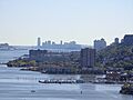
The Hudson Waterfront skyline
-
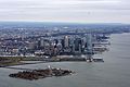
Ellis Island and Downtown Jersey City looking north

