
Hurricane Debby (2000) facts for kids
| Category 1 hurricane (SSHWS/NWS) | |

Hurricane Debby near peak intensity near the Leeward Islands on August 22
|
|
| Formed | August 19, 2000 |
|---|---|
| Dissipated | August 24, 2000 |
| Highest winds | 1-minute sustained: 85 mph (140 km/h) |
| Lowest pressure | 991 mbar (hPa); 29.26 inHg |
| Fatalities | 1 indirect |
| Damage | $735,000 (2000 USD) |
| Areas affected | Lesser Antilles, Puerto Rico, Hispaniola, Turks and Caicos Islands, Cuba, Jamaica |
| Part of the 2000 Atlantic hurricane season | |
Hurricane Debby was a storm that caused some damage in the Greater Antilles and Lesser Antilles in August 2000. It was the seventh tropical cyclone and the second hurricane of the 2000 Atlantic hurricane season.
Debby started as a tropical wave east of the Lesser Antilles on August 19. It quickly grew into Tropical Storm Debby on August 20. Just 24 hours later, it became a hurricane. On August 21, its winds reached their strongest at 85 mph (140 km/h). Debby hit land three times on August 22: in Barbuda, Saint Barthélemy, and Virgin Gorda. After that, it moved north of Puerto Rico.
As Debby moved near the north coast of Hispaniola on August 23, it got weaker and became a tropical storm again. The storm then moved west and weakened even more. It did not become a major hurricane or hit Florida as some had feared. On August 24, while south of eastern Cuba, Debby weakened into a tropical depression. It completely disappeared six hours later.
The storm caused light rain and strong winds, leading to minor damage in places like Barbuda and Saint Martin. In the United States Virgin Islands, there were short power outages. Damage there reached about $200,000. The worst effects were in Puerto Rico. Some areas got more than 12 inches (300 mm) of rain. This heavy rain caused mudslides and floods, damaging roads, bridges, and homes. Over 400 homes were flooded, and five were badly damaged. Many car accidents happened in San Juan because of slippery roads. Sadly, one person died indirectly. He fell off his roof while trying to remove a satellite dish. Damage in Puerto Rico was about $501,000.
In the Dominican Republic, severe flooding in the north made over 700 people leave their homes. The storm caused about $35,000 in damage there. In Haiti, strong winds ripped tin roofs off many small homes. Rain in Cuba helped end a long drought.
Contents
How Hurricane Debby Formed and Moved

A strong weather system called a tropical wave moved into the Atlantic Ocean from Africa on August 16. By August 17, a low-pressure area was seen. However, it was not strong enough to be classified yet.
On August 18, the National Hurricane Center saw a low-level circulation. This means the air was starting to spin. The system slowly became more organized as it moved west. By August 19, the storm had a clear center. It was then named Tropical Depression Seven. It was about 1,035 miles (1,665 km) east of the Windward Islands. The National Hurricane Center noted that the warm ocean waters and calm winds were perfect for the storm to get stronger.
Debby Becomes a Tropical Storm and Hurricane
The depression grew into Tropical Storm Debby on August 20. At first, it was hard to find the exact center of the storm. But the storm had a large, round area of very cold cloud tops. This showed it was getting stronger.
By August 21, Debby became a Category 1 hurricane. Its strongest winds reached 85 mph (140 km/h). The lowest pressure in the storm was 991 mbar. Hurricane-force winds were only found close to the storm's center, about 25 miles (40 km) out.
.jpg)
On August 22, Debby made its first landfall in Barbuda with winds of 75 mph (120 km/h). A few hours later, it hit Saint Barthélemy with the same wind speed. Debby then made a third landfall in Virgin Gorda with 75 mph (120 km/h) winds.
Later that day, the storm passed about 35 miles (56 km) north of Puerto Rico. Forecasters thought Debby might get stronger. But they also knew it was moving fast and could interact with land, like Hispaniola.
Debby Weakens and Disappears
By August 23, Debby started to weaken. This was because of increasing winds high in the atmosphere. It was downgraded to a tropical storm while north of the Dominican Republic.
Forecasters thought Debby might get stronger again. The ocean waters were still warm, and they expected the storm to move away from land. However, Debby turned west and became more disorganized. Its center of circulation moved far from the main storm clouds.
On August 24, the storm entered the Windward Passage and passed south of Cuba. The National Hurricane Center still thought it might get stronger. But they also said it could turn into a tropical wave because of strong winds in the atmosphere. Three hours later, Debby was downgraded to a tropical depression. By the end of August 24, it had completely disappeared south of Cuba.
Preparing for Hurricane Debby

Many warnings were issued for the islands in the Greater and Lesser Antilles. People prepared for the storm. In Philipsburg, Sint Maarten, shops boarded up their windows. Homes and businesses were protected, and families buried emergency supplies.
Ten United States Navy ships and two submarines moved away from Vieques Island. They went over 300 miles (480 km) south of Puerto Rico to avoid the storm. On Antigua, electricity was turned off to protect the island's power system. The Hovensa oil refinery in St. Croix was shut down when the hurricane moved near the U.S. Virgin Islands. This caused gas prices to go up.
Evacuations and Shelters
About 7,000 people in Cuba were moved to safer places. The Montserrat Red Cross opened shelters on Montserrat, but not many people used them. Over 40 shelters were ready in Nassau, Bahamas, even though Debby did not affect that island. A total of 889 people in the northern coastal areas of the Dominican Republic were moved to shelters.
In the U.S. Virgin Islands, three shelters opened in Saint Thomas and two in Saint John. Only 64 people used these shelters. Another 17 people went to shelters on Saint Croix.
Storm Warnings and Watches
Many tropical cyclone warnings and watches were put in place.
- On August 20, a hurricane watch was issued for Sint Maarten, Saba, and Sint Eustatius. A tropical storm watch was issued for Antigua, Barbuda, and Anguilla.
- On August 21, the hurricane watch included the United States Virgin Islands and Puerto Rico. The tropical storm watch was extended to the British Virgin Islands, Guadeloupe, Montserrat, Saint Barthélemy, Saint Kitts and Nevis, and Saint Martin.
- Later on August 21, a hurricane warning was issued for Guadeloupe, Puerto Rico, and the Virgin Islands.
- The Dominican Republic had a tropical storm watch. Haiti north of Port-au-Prince also got a hurricane watch.
- On August 22, a tropical storm watch was put in place for the southeastern Bahamas and Turks and Caicos Islands. The entire north coast of the Dominican Republic was under a hurricane warning.
Many warnings were then canceled as the storm moved on. By August 25, all tropical cyclone watches and warnings were gone.
Even though the hurricane was far from Florida, a state of emergency was declared for the Florida Keys. People who didn't live in Monroe County had to leave. This caused a big drop in tourism. Forecasters had predicted Debby might hit the Florida Keys as a Category 2 hurricane. One computer model even suggested it could be a much stronger Category 4 hurricane.
Impact of Hurricane Debby
Hurricane Debby was not very strong or organized. So, its effects were spread out but not extremely severe. Puerto Rico was hit the hardest, followed by the United States Virgin Islands and the Dominican Republic. Overall, Debby caused about $735,000 in damage. Sadly, one person died indirectly in Puerto Rico. This happened when a man fell off a roof while trying to remove a satellite dish.
Impact in the Lesser Antilles
Across the Leeward Islands, strong winds damaged fruit trees and knocked down power lines.
- In Anguilla, wind gusts reached 65 mph (100 km/h). Some trees were destroyed, and power poles were downed.
- In Antigua, utility poles and trees were knocked down. It rained about 0.91 inches (23 mm).
- Barbuda received 1.5 inches (38 mm) of rain. Debby caused some roof damage and destroyed a few sheds and fruit trees.
- Sint Maarten had little rain and mostly minor flooding. Damage was almost zero, except for lost money from canceled cruise ships and closed businesses.
On Saint Barthélemy, wind gusts reached 87 mph (140 km/h) in Gustavia. Wind damage was minor, mostly to trees and power poles. Rainfall was very light, between 0.59 to 0.98 inches (15 to 25 mm). Tides were about 13 feet (4 m) higher than normal. Similar high waves were seen on Saint Martin. Rainfall there was slightly higher, from 0.78 to 1.37 inches (20 to 35 mm).
The impact was minimal on Guadeloupe. Waves reached about 10 feet (3 m). Rainfall was also light, with different amounts in various towns. Rain from Debby's outer bands reached as far south as Trinidad and Tobago. Heavy rain there caused flooding in the Barrackpore area.
Impact in United States Territories
In the United States Virgin Islands, losses were about $200,000.
- On Saint Thomas, 1.93 inches (49 mm) of rain fell. Winds reached 33 mph (53 km/h), with gusts up to 45 mph (72 km/h). One sailboat was washed ashore.
- On Saint Croix, winds of 35 mph (56 km/h) with gusts of 43 mph (69 km/h) caused short power outages. It rained 0.46 inches (11.7 mm).
- Minor landscape damage happened on Saint John.
Debby dropped up to 12 inches (30.5 mm) of rain across Puerto Rico in less than 48 hours. This caused mudslides and damage to bridges and roads. However, most of the island only got about 3 inches (7.62 mm) of rain. The most rain, 12.63 inches (32 mm), fell in Río Piedras, Puerto Rico. Unofficial reports said some mountain areas got 17 inches (430 mm).
The hurricane dropped about 5 inches (127 mm) of rain in San Juan. This made roads slippery and led to several minor car accidents. Flooding affected 406 homes, and 5 of them were badly damaged. Losses in Puerto Rico reached $501,000, mainly in the Caguas area.
Impact in the Dominican Republic
On the northern coast of the Dominican Republic, waves and rain caused light to moderate damage. Storm surge damaged about 20 homes. Dozens of families had to leave their homes in Cabrera, Nagua, Río San Juan, and Samaná. In Nagua, several areas lost drinking water and electricity because winds knocked down power lines and trees.
In San José de Matanzas, several coconut trees were pulled out of the ground. Two houses were slightly damaged by wind. In La Vega, bridges over the Piedra River and Jumunucu River collapsed due to heavy rain and flooding. In southern Puerto Plata, flooding forced many families to leave their houses. In Monte Cristi, heavy rain caused flooding in low-lying areas, affecting over 200 people.
Another town, Salcedo, lost about 23 square miles (60 km²) of bananas. This damage was estimated to be about $35,000. The country's Civil Defense Force said over 700 people on the northern coast had to leave their homes because of severe flooding. A wedding at a beach resort was also delayed because flooding made the altar area unusable.
Impact in Haiti and Cuba
In northern Haiti, people living in small homes called shanties had to leave during the storm. In Port-de-Paix, strong winds tore off many tin roofs and flooded some homes. In a small coastal village called Carenage, high winds sank at least five boats. Storm surge also washed away one home, but no one was hurt or died.
In Cuba, the leftover parts of Debby brought rain to the eastern part of the country, especially Guantánamo Province. Some areas received over 3 inches (76 mm) of rain in 24 hours. This rain was very helpful because Guantanamo Province had been in a severe eight-month drought. As a safety step, over 32,000 people and thousands of cattle in low-lying areas were moved to higher ground to avoid possible flooding.
Some places reported strong winds. In Maisí, winds were between 29 and 31 mph (47 and 50 km/h), with gusts up to 42 mph (68 km/h). Also, high tides caused coastal flooding in Baracoa.
Images for kids
-
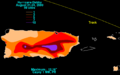
Rainfall from Hurricane Debby in Puerto Rico and the U.S. Virgin Islands
-
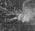
Tropical Storm Debby interacting with the high and rugged mountains of Hispaniola on August 23


See also
 In Spanish: Huracán Debby (2000) para niños
