
Martinez, California facts for kids
Quick facts for kids
Martinez
|
||
|---|---|---|
|
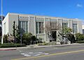
Contra Costa County Courthouse
Carquinez Strait
Vicente Martínez Adobe
Contra Costa Hall of Records
|
||
|
||
| Nickname(s):
The Bay Area's Hidden Gem (official)
|
||

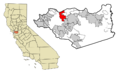
Location in Contra Costa County and the state of California
|
||

Martinez
Location in San Francisco Bay Area

Martinez
Location in California

Martinez
Location in the United States
|
||
| Country | United States | |
| State | California | |
| County | Contra Costa | |
| Incorporated | April 1, 1876 | |
| Area | ||
| • Total | 13.63 sq mi (35.31 km2) | |
| • Land | 12.63 sq mi (32.71 km2) | |
| • Water | 1.00 sq mi (2.60 km2) 7.64% | |
| Elevation | 23 ft (7 m) | |
| Population
(2020)
|
||
| • Total | 37,287 | |
| • Density | 2,735.7/sq mi (1,055.99/km2) | |
| Time zone | UTC-8 (Pacific) | |
| • Summer (DST) | UTC-7 (PDT) | |
| ZIP code |
94553
|
|
| Area code | 925 | |
| FIPS code | 06-46114 | |
| GNIS feature IDs | 277553, 2411045 | |
.jpg)
.jpg)
_-_panoramio_(1)_(cropped).jpg)
.jpg)

Martinez (in Spanish: Martínez) is a city in California, United States. It is the main city and county seat of Contra Costa County, California. Martinez is located in the East Bay area of the San Francisco Bay Area.
The city sits on the southern shore of the Carquinez Strait. In 2020, about 37,287 people lived there. Martinez was named after Californio rancher Ygnacio Martínez. It was founded on his land, called Rancho El Pinole. The city is known for its old downtown area and its waterfront.
Contents
History of Martinez
_-_panoramio_(cropped).jpg)
.jpg)
The beautiful Alhambra Valley was likely a place where the Karkines Indians found food. These Karkines people were part of the Ohlone (Costanoan) Indian group.
In 1824, the western part of Martinez, including Alhambra Valley, became part of a Mexican land grant. This land, called Rancho El Pinole, was given to Ygnacio Martínez. East of this land was Rancho Las Juntas, given to William Welch in 1844.
In 1847, Dr. Robert Semple started a ferry service from Martinez to Benicia. For many years, this was the only way to cross the Carquinez Strait. By 1849, Martinez was a stop for people heading to the California Gold Rush. The town was planned in 1849 by Col. William M. Smith and named after Martinez. It became the county seat in 1850. However, it could not become a city until 1876 because it needed 200 registered voters.
Martinez was the home of famous naturalist John Muir from 1880 until he passed away in 1914. He is buried about a mile south of the John Muir National Historic Site. Also nearby is the Vicente Martínez Adobe, built in 1849 by Ygnacio Martinez's son. The first post office in Martinez opened in 1851.
In 1860, Martinez was important for the Pony Express. Riders would take the ferry from Benicia if they missed the boat in Sacramento.
The first oil refinery in the Martinez area was built in 1904. It was located at Bull's Head Point, an area east of downtown. This area later became known as Mococo. This happened after a metal processing plant, the Mountain Copper Company (Mo Co Co), arrived in 1905.
.jpg)
The first refinery was run by the Bull's Head Oil Company. In 1908, Pacific Coast Oil Company built a test refinery. Later, Pacific Coast joined Standard Oil (now Chevron). They moved their refining work to other areas west of Martinez.
In 1913, the Golden Eagle facility became the third oil refinery in the area. It was in the new town of Avon, next to Martinez. A fourth refinery, built by Shell Oil Company, started in 1916. The Shell Oil refinery is still working today (owned by PBF Energy). This keeps Martinez as an important place for processing oil. The Golden Eagle Refinery (now Marathon Petroleum Company) stopped working in April 2020. This was due to less demand for oil during the COVID-19 pandemic.
Some people in Martinez believe the Martini cocktail was invented there and named after the city.
Geography and Nature

Martinez covers about 13.1 square miles (34 square kilometers). About 1.0 square mile (2.6 square kilometers) of this is water.
The city is mostly surrounded by water and natural open spaces. The Martinez–Benicia Bridge carries Highway 680 over the Carquinez Strait to Solano County. Downtown Martinez is in a valley with Alhambra Creek flowing through it. Suburban areas spread south of Highway 4 towards Pleasant Hill. Rural areas include the Alhambra Valley and Franklin Canyon.
The Martinez Regional Shoreline is along the Carquinez Strait to the north. The Carquinez Strait Regional Shoreline includes the Franklin Hills west of downtown. It stretches to Port Costa and Crockett. Briones Regional Park is south of the Alhambra Valley. Waterbird Regional Preserve and the McNabney Marsh are east of the city. Martinez's location offers great water views, even reaching the Sierra mountains. From nearby hilltops, you can see Mount Diablo, Mount Saint Helena, and Mount Tamalpais.
.jpg)
Martinez is one of only two places in the Bay Area where two major trails meet. These are the Bay Area Ridge Trail and the San Francisco Bay Trail. The Bay Trail is a planned path for biking and hiking. When finished, it will go around San Francisco and San Pablo bays. It will be about 400 miles (640 km) long and connect 47 cities. So far, about 240 miles (390 km) are complete.
The Bay Area Ridge Trail will be over 500 miles (800 km) long. It will go along the hilltops around the San Francisco Bay. This trail is for hikers, horseback riders, and mountain bikers. Over 300 miles (480 km) of this trail are ready to use. The East Bay Regional Park District's Iron Horse Regional Trail will join the Bay Trail along the waterfront. The Contra Costa Canal Trail also goes through Martinez from Pleasant Hill.
Climate in Martinez
Martinez has a mild Mediterranean climate. Summers are warm and dry. There can be some morning fog when sea breezes come in. The ocean's effect is less here than in other Bay Area places closer to the Pacific. This means summer daytime temperatures are higher than in San Francisco or Oakland. However, nights usually cool down a lot. In July and August, daytime highs are around 87°F (31°C) and nighttime lows are about 55°F (13°C). Winters are wet and cool, with some frost. Most of the city is in a USDA hardiness zone of 9b.
| Climate data for Martinez, California | |||||||||||||
|---|---|---|---|---|---|---|---|---|---|---|---|---|---|
| Month | Jan | Feb | Mar | Apr | May | Jun | Jul | Aug | Sep | Oct | Nov | Dec | Year |
| Record high °F (°C) | 74 (23) |
80 (27) |
88 (31) |
98 (37) |
104 (40) |
110 (43) |
115 (46) |
107 (42) |
108 (42) |
103 (39) |
82 (28) |
74 (23) |
115 (46) |
| Mean daily maximum °F (°C) | 55.2 (12.9) |
60.9 (16.1) |
66.0 (18.9) |
71.7 (22.1) |
78.9 (26.1) |
85.3 (29.6) |
89.0 (31.7) |
88.1 (31.2) |
84.9 (29.4) |
76.4 (24.7) |
64.0 (17.8) |
55.6 (13.1) |
73.0 (22.8) |
| Daily mean °F (°C) | 46.9 (8.3) |
51.2 (10.7) |
55.1 (12.8) |
58.7 (14.8) |
64.2 (17.9) |
69.3 (20.7) |
71.7 (22.1) |
71.2 (21.8) |
69.1 (20.6) |
62.6 (17.0) |
53.6 (12.0) |
47.1 (8.4) |
60.1 (15.6) |
| Mean daily minimum °F (°C) | 38.6 (3.7) |
41.4 (5.2) |
44.1 (6.7) |
45.7 (7.6) |
49.5 (9.7) |
53.2 (11.8) |
54.5 (12.5) |
54.3 (12.4) |
53.3 (11.8) |
48.9 (9.4) |
43.2 (6.2) |
38.5 (3.6) |
47.1 (8.4) |
| Record low °F (°C) | 20 (−7) |
25 (−4) |
29 (−2) |
29 (−2) |
34 (1) |
31 (−1) |
41 (5) |
42 (6) |
40 (4) |
34 (1) |
25 (−4) |
19 (−7) |
19 (−7) |
| Average precipitation inches (mm) | 3.93 (100) |
3.61 (92) |
2.92 (74) |
1.20 (30) |
0.47 (12) |
0.10 (2.5) |
0.02 (0.51) |
0.05 (1.3) |
0.18 (4.6) |
0.95 (24) |
2.52 (64) |
3.44 (87) |
19.39 (491.91) |
| Average precipitation days (≥ 0.01 in) | 11 | 10 | 9 | 6 | 3 | 1 | 0 | 0 | 1 | 3 | 8 | 10 | 62 |
| Source: Western Regional Climate Center | |||||||||||||
People of Martinez

| Historical population | |||
|---|---|---|---|
| Census | Pop. | %± | |
| 1870 | 560 | — | |
| 1890 | 1,609 | — | |
| 1900 | 1,380 | −14.2% | |
| 1910 | 2,115 | 53.3% | |
| 1920 | 3,858 | 82.4% | |
| 1930 | 6,569 | 70.3% | |
| 1940 | 7,381 | 12.4% | |
| 1950 | 8,268 | 12.0% | |
| 1960 | 9,604 | 16.2% | |
| 1970 | 16,506 | 71.9% | |
| 1980 | 22,582 | 36.8% | |
| 1990 | 31,808 | 40.9% | |
| 2000 | 35,866 | 12.8% | |
| 2010 | 35,824 | −0.1% | |
| 2020 | 38,290 | 6.9% | |
| U.S. Decennial Census | |||
The 2020 Census showed that Martinez had 38,290 people. Most people (77.1%) were White. About 8.0% were Asian, and 3.6% were African American. About 14.7% of the people were Hispanic or Latino.
Most people (96.4%) lived in homes. The average household had 2.42 people. About 29.9% of homes had children under 18. About 47.5% of homes were married couples. The average family size was 2.95 people.
The population's age spread showed that 20.5% were under 18. About 33.8% were between 45 and 64 years old. And 12.1% were 65 or older. The average age was 42.2 years.
Economy and Jobs
.jpg)
Martinez has many different types of jobs. The largest employers in the city include government offices and healthcare providers.
Main Employers in Martinez
Here are the top employers in Martinez as of 2021:
| # | Employer | # of Employees |
|---|---|---|
| 1 | Contra Costa County | 10,065 |
| 2 | Veterans Health Administration | 962 |
| 3 | Kaiser Permanente | 730 |
| 4 | Equilon Enterprises | 702 |
| 5 | Martinez Unified School District | 672 |
| 6 | Wal-Mart | 275 |
| 7 | Safeway | 190 |
| 8 | City of Martinez | 136 |
| 9 | The Home Depot | 125 |
| 10 | Brand Energy & Infrastructure Service | 120 |
Education and Libraries
.jpg)
The Martinez Unified School District serves most of Martinez. It has four elementary schools, one middle school, and one high school. There are also two alternative schools. Students in kindergarten through 5th grade go to John Swett, John Muir, Las Juntas, or Morello Park Elementary School. Martinez Junior High School is for grades 6 to 8. Alhambra High School is the main high school. In 2006, about 4,194 students were enrolled in K-12 schools.
Some parts of Martinez are served by the Mount Diablo Unified School District. Their Hidden Valley Elementary School is in Martinez. St. Catherine of Siena School is a private Catholic elementary school in Martinez.
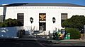
Martinez Public Library
The Martinez Library is part of the Contra Costa County Library system. It is located in Martinez. The library building has an Art Deco style. It was added to the National Register of Historic Places in 2008.
Local News and Media

Martinez and the nearby areas have several local newspapers. These include the Martinez News-Gazette, the Martinez Tribune, and the East Bay Times.
Martinez also has local news websites like Martinez Patch and the Claycord.com blog.
In late 2019, there were reports that the Martinez News-Gazette might stop printing. This newspaper is one of the oldest in California, started 161 years ago. However, the newspaper continued to operate. It stopped its print edition temporarily in April 2020 due to low advertising. This was because many local businesses closed during the COVID-19 pandemic. The newspaper plans to print again when local rules allow. Its online news website continued during the pandemic.
Getting Around Martinez


Local bus services help people get around Martinez and nearby areas. WestCAT provides service to the El Cerrito del Norte BART station. The County Connection is the main local bus company. It goes to the Concord, Pleasant Hill, and Walnut Creek BART stations. Tri Delta Transit also has express service between Martinez and eastern Contra Costa County.
State Route 4 runs through Martinez. It goes west to Hercules and east towards Stockton and the Sierra Nevada mountains. Interstate 680 goes north over the Benicia–Martinez Bridge towards Sacramento. It also goes south towards San Jose.
Train Services
- Amtrak, the national passenger train system, has trains that stop in Martinez. The California Zephyr goes daily between Emeryville (near San Francisco) and Chicago. It also stops in Sacramento, Reno, and other cities.
- Amtrak's Coast Starlight also runs daily through Martinez. It travels between Seattle and Los Angeles.
- Amtrak California runs its Capitol Corridor trains through Martinez station. These trains offer service several times a day. They go from San Jose in the west to Auburn in the east (through Sacramento).
- Amtrak California's San Joaquin trains also pass through Martinez. They provide service several times daily from Oakland to Bakersfield. Bus connections from these trains can take you to places like San Diego, Las Vegas, and Medford, Oregon. One bus connection starts in Martinez and goes north to the Eureka area.
- The BART system has a stop called North Concord/Martinez station. This station is a few miles east of Martinez. BART's future plans include a new line that would go through the I-680 area and end in Martinez.
- The 1,600-foot (490 m) long, 75-foot (23 m) high steel "Muir Trestle" (also called "Alhambra Trestle") carries freight trains. These trains are operated by the BNSF Railway and run parallel to California State Route 4.
Sister Cities
Martinez has special connections with cities in other countries. These are called sister cities. According to Sister Cities International, Martinez is connected with:
 Dunbar, Scotland, United Kingdom
 Hanchuan, China
 Milazzo and Stresa, Italy
Famous People from Martinez
Many notable people have connections to Martinez:
- Maurice Benard, born in 1963, is an actor known for General Hospital.
- Yau-Man Chan, born in 1952, is a table tennis player and technology executive.
- Trevor Davis, born in 1993, is an American football wide receiver.
- Sara Del Rey, born in 1980, is a wrestling trainer and former professional wrestler.
- Joe DiMaggio, (1914–1999), was a famous baseball player for the New York Yankees.
- Vince DiMaggio, (1912–1986), was an All-Star baseball player for the Pittsburgh Pirates.
- Ainjel Emme, born in 1978, is an American singer-songwriter and producer.
- Robb Flynn, born in 1967, is the lead singer and guitarist for the band Machine Head.
- Najee Harris, born in 1998, is an American football running back for the Pittsburgh Steelers.
- Mark Kozelek, born in 1967, is an American singer, songwriter, and guitarist.
- Ella Leffland, born in 1931, is an American novelist and short story writer.
- Tug McGraw, (1944–2004), was a professional baseball pitcher and father of singer Tim McGraw.
- Seanan McGuire, born in 1978, is an author.
- John Muir, (1838–1914), was a famous naturalist.
- Richard Rodgers II, born in 1992, is an American football tight end.
- Sabato "Simon" Rodia, (1879 or 1886–1965), created the Watts Towers in Los Angeles.
- Victor Salva, born in 1958, is an American filmmaker.
- J. Otto Seibold, born in 1960, is an American artist and children's book creator.
- Robert Stephenson, born in 1993, is a professional baseball pitcher.
- Jim Turner, (1941–2023), was a former football placekicker.
- Norv Turner, born in 1952, is an American football coach.
- Jeff Van Gundy, born in 1962, is a basketball commentator and former coach.
- Stan Van Gundy, born in 1959, is a basketball commentator and former coach. He is Jeff's older brother.
- Travis Williams, (1946–1991), was an American football player.
Images for kids
-
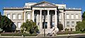
Contra Costa County Courthouse
-
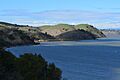
Carquinez Strait
-
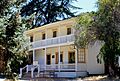
Vicente Martínez Adobe
-
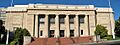
Contra Costa Hall of Records
-
Flag of Martinez, California
-
Location in Contra Costa County and California
-
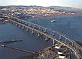
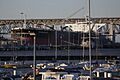
The Benicia-Martinez Bridge
-
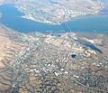
Aerial view of Martinez
-
View from the Martinez Marina
-
Downtown Martinez
-
The historic Art Deco style Martinez Library
-
The historic post office
-
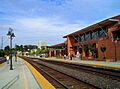
Martinez station
-
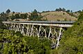
The Alhambra Trestle
See also
 In Spanish: Martinez (California) para niños
