
Punjab (Pakistan) facts for kids
Quick facts for kids
Punjab
پنجاب
|
|||
|---|---|---|---|
      Clockwise from top left: Badshahi Mosque, Noor Mahal, Alamgiri Gate, Naulakha Pavilion, Tomb of Shah Rukn-e-Alam and Derawar Fort
|
|||
|
|||
.svg)
Location of Punjab in Pakistan
|
|||
| Country | |||
| Established | 1 July 1970 | ||
| Capital and largest city |
Lahore | ||
| Government | |||
| • Type | Self-governing Province subject to the Federal Government | ||
| Area | |||
| • Total | 205,344 km2 (79,284 sq mi) | ||
| Population | |||
| • Total | 110,012,442 | ||
| • Density | 535.7470/km2 (1,387.578/sq mi) | ||
| Time zone | UTC+5 (PST) | ||
| ISO 3166 code | PK-PB | ||
| Main Language(s) | |||
| Notable sports teams | Lahore Qalandars Multan Sultans Lahore Lions Rawalpindi Rams Sialkot Stallions Bahawalpur Stags Multan Tigers Faisalabad Wolves |
||
| Seats in National Assembly | 183 | ||
| HDI (2017) | 0.732 | ||
| Seats in Provincial Assembly | 371 | ||
| Divisions | 10 | ||
| Districts | 36 | ||
| Tehsils | 146 | ||
| Union Councils | 7602 | ||


Punjab (Urdu: صوبہ پنجاب) is a large province in Pakistan. Its capital city is Lahore. Punjab is home to about 120 million people. It covers an area of 205,344 square kilometers. This makes it bigger than Kyrgyzstan but smaller than Belarus.
Contents
What Does 'Punjab' Mean?
The name Punjab comes from two old words: panj (meaning five) and āb (meaning water). So, Punjab means "the land of five rivers." These five rivers are the Indus, Chenab, Jhelum, Ravi, and Sutlej. Sometimes, people call it "the Punjab." The name was first used by Turkic Muslim rulers and became popular during the Mughal Empire around the 1600s.
A Look at Punjab's Past
Before 1947, both Pakistan and India were ruled by the British. The Punjab province was part of British Punjab. In 1947, when British rule ended, Punjab was divided. One part became part of Pakistan, and the other part became part of India. This division happened along a line called the Radcliffe Line.
Today, India has a state also called Punjab. In 2006, a bus service started connecting Lahore in Pakistani Punjab with Amritsar in Indian Punjab. This was the first bus service between the two Punjabs in almost 60 years. It helped people from both sides visit each other.
The Wagah Border Ceremony
Wagah is a village that was split in half by the border in 1947. One part is in India, and the other is in Pakistan. Wagah is famous for a special ceremony that happens every day before 5 PM. Soldiers from both countries perform an elaborate flag-lowering ceremony at the border gate. It's a popular event for visitors.
Growth and Changes
Since the 1950s, Punjab has grown quickly. Many new factories were built in cities like Lahore, Multan, Sialkot, and Wah. In the 1960s, the new capital city of Islamabad was built close to Rawalpindi.
Agriculture is still a very important part of Punjab's economy. The province grows a lot of food for the country. Most of the land is owned by a few large land-owning families.
In the 1950s, Punjab became part of a larger province called West Pakistan. But in 1972, after Bangladesh became a separate country, Punjab became its own province again.
Punjab was also a site of major battles between the armies of India and Pakistan in the wars of 1965 and 1971. Since the 1990s, Punjab has hosted important sites for Pakistan's nuclear program and military bases.
Since 2004, India and Pakistan have worked towards peace. This has helped improve trade and travel between the two countries. Many Indian Sikh pilgrims now visit holy sites in Punjab, Pakistan, like Nankana Sahib.
Starting in the 1980s, many people from Punjab moved to other countries. They went to the Middle East, Britain, Spain, Canada, and the United States to find better jobs. These people form a large Punjabi community living outside Pakistan.
Where is Punjab?
Punjab is Pakistan's second largest province. It is located in South-central Asia. The capital and largest city is Lahore. Other important cities include Multan, Faisalabad, Sheikhupura, Sialkot, Gujranwala, Jhelum, and Rawalpindi.
Six rivers flow through the wider Punjab region. Five of them flow through Pakistani Punjab: the Indus, Jhelum, Beas, Chenab, Ravi, and Sutlej.
Nearly 60% of Pakistan's population lives in Punjab. It is the only province that touches every other province in Pakistan. It also surrounds the federal area where the national capital, Islamabad, is located. This central location means Punjab is very aware of the issues in other parts of Pakistan.
Punjab's Landscape
Most of Punjab is a very fertile area along river valleys. This land is heavily irrigated with canals to help grow crops. You can also find sparse deserts near the border with Rajasthan and the Sulaiman Range. The Thar and Cholistan deserts are in this region.
The weather in Punjab can be extreme. It's hot and dry in the south, but cooler in the hills of the north. The foothills of the Himalayas are found in the far north of the province.
Districts of Punjab
Related Pages
Images for kids
-
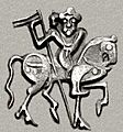
Horseman on an old coin.
-
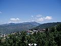
Punjab has mountains near the hill station of Murree.
-
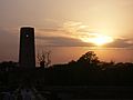
A beautiful sunset in Punjab during summer.
-
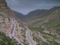
A road block from a landslide near Dera Ghazi Khan.
-
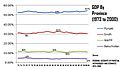
GDP by Province.
-
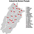
Industrial Zones in Punjab.
-
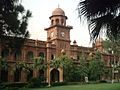
Government College University, Lahore.
-
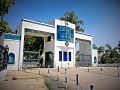
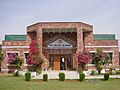
Main entrance to The university of Sargodha.
-
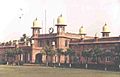
A women's college in Rawalpindi.
-
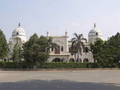
University of the Punjab.
-
University of Agriculture, Faisalabad.
-
King Edward Medical University, Lahore.
-
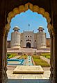
The Lahore Fort, a historic site from the Mughal era, is a UNESCO World Heritage Site.
-
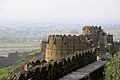
Rohtas Fort, a UNESCO world heritage site, built on a hill.
-
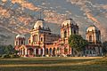
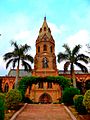
The front of Noor Mahal in Bahawalpur.


See also
 In Spanish: Punyab (Pakistán) para niños
