Transportation in Indianapolis facts for kids
Transportation in Indianapolis is like a big, busy network that helps people and goods move around. It includes a local public bus system, several private bus companies that travel between cities, Amtrak passenger trains, four freight train lines, a huge system of Interstate highways, an airport, a heliport, a bike-sharing program, about 115 miles (185 km) of bike lanes, and 116 miles (187 km) of trails and greenways. Indianapolis has also become well-known for its many electric scooters!
Contents
How Transportation in Indianapolis Began
The city of Indianapolis was first built near the White River because people thought boats could easily travel on it. However, the river turned out to be too shallow for big commercial ships. After a steamboat got stuck in 1831, no other steamboat successfully returned to Indianapolis. Smaller flatboats continued to carry goods for a while until new dams blocked their path.
Early Roads and Highways
In 1821, the Indiana General Assembly (Indiana's state government) decided to build ten state roads to connect Indianapolis with other towns. By 1836, the National Road reached Indianapolis. This road was the first major improved highway in the country built by the U.S. government. It was built between 1811 and 1837 and stretched about 620 miles (998 km) from Maryland to Illinois. The Michigan Road, which cut through Indiana from north to south, was finished in 1839. This road connected Indianapolis to important ports like Michigan City, Indiana, and Madison, Indiana, allowing goods to travel by water through Lake Michigan and the Ohio River.
The Rise of Railroads
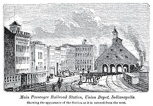
The first two trains arrived in Indianapolis on October 1, 1847, celebrating the completion of the Madison and Indianapolis Railroad. Within five years, seven different train lines met in the city. Indianapolis was a pioneer in the idea of a "union station," which means one big train station used by many different railroad companies. In 1849, the competing train companies worked together to create the Indianapolis Union Railway Company. They opened the world's first union depot on September 20, 1853.
As the city and train traffic grew, the first union depot became too small. A larger Indianapolis Union Station was built in 1886 and opened in 1888. When it opened, it handled 80 passenger trains every day from 16 different companies! By 1893, about 25,000 passengers rode an average of 120 trains daily. By 1900, 150 trains were arriving each day. With so much train traffic, there were many dangerous crossings where roads and train tracks met. Between 1905 and 1920, the city worked with the railroads to raise the tracks above the roads.
Streetcars and Public Transit
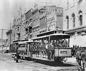
Public transportation started in Indianapolis on October 3, 1864, with 12-seat mule-drawn streetcars. These streetcars ran between Union Station and Military Park. The Citizens Street Railway Company managed several streetcar lines that spread out from downtown Indianapolis to nearby neighborhoods. The first electric streetcar began operating on June 18, 1890, and by 1894, all the mule-drawn streetcars were replaced. Electric streetcars made travel much faster and easier, allowing people to live further away from the city center. This led to the growth of "streetcar suburbs" like Irvington and Woodruff Place.
Interurban Trains
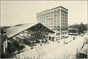
On January 1, 1900, the first interurban train arrived in Indianapolis from Greenwood, Indiana. Interurbans were electric trains that connected cities and towns. To handle the growing popularity of interurban travel, the Indianapolis Traction Terminal opened in September 1904. It served almost all of the 13 interurban lines that came into the city. This terminal was the busiest interurban station in the world, serving as the center for Indiana's huge 1,825-mile (2,937 km) interurban system. At its busiest, the terminal handled over 600 trains daily and seven million passengers each year! However, as cars became more popular, interurban travel declined. The terminal served its last interurban train in September 1941.
Aviation Takes Flight

Some of the first airplanes to fly in Indianapolis took off at the Indianapolis Motor Speedway during the first licensed aviation meet in the U.S. This event, from June 13–18, 1910, was also the first public demonstration of airplanes in Indiana. Famous aviators like the Orville and Wilbur Wright participated, drawing thousands of people. As airplanes improved, several airfields opened in Indianapolis in the 1920s. The city's first public landing strip opened in July 1920. Later airfields included Crawford Field (1922), Schoen Field (1922), and Cox Field (1926). Cox Field was the city's first municipal (city-owned) airport and hosted Indianapolis's first regular commercial flight on December 17, 1927. The Indianapolis Municipal Airport, now known as Indianapolis International Airport, was dedicated on September 25, 1931.
After World War II, fewer people rode electric streetcars as more families bought their own cars. In 1952, over 400 public transit vehicles traveled more than 43,000 miles (69,202 km) daily, carrying 72 million passengers each year. The city's last streetcar was retired in January 1953, replaced by trackless trolleys and motor buses.
Building the Interstate Highways
With the passing of the Federal Aid Highway Act of 1956, major construction of the Interstate Highway System began in Indianapolis in 1959. The Interstate 465 beltway, a highway that circles the city, was completed on October 5, 1970. Sections of Interstates 65, 69, 70, and 74 in Indianapolis were mostly finished by the mid-1970s.
In 1961, the Indiana General Assembly allowed for the creation of a local group to manage air transportation. In 1962, the Indianapolis Airport Authority was created for this purpose. Indianapolis International Airport has been expanded many times since it opened in 1931. The most recent expansion, costing $1.1 billion, was finished in 2008. The large Colonel H. Weir Cook Terminal opened on November 11, 2008.
Indianapolis was home to the first electric carsharing service in the U.S., called BlueIndy. It started in September 2015 and stopped in May 2020. At its peak, BlueIndy had 200 electric cars and 92 charging stations around the city.
Getting Around Between Cities
The transportation system in the Indianapolis metropolitan area (the city and its surrounding areas) includes an international airport, nine smaller airports for general aviation, several private bus companies, Amtrak passenger train service, and four freight train lines. The region's main highways are part of the Interstate Highway System.
Air Travel

Indianapolis International Airport is the main commercial airport for the region. In 2021, it served 7.1 million passengers and handled 1.3 million metric tons of cargo. The airport is owned and operated by the Indianapolis Airport Authority. It completed a new air traffic control tower in 2006 and a new terminal in 2008. The Colonel H. Weir Cook Terminal has two concourses and 40 gates, connecting to 51 nonstop places in the U.S. and other countries. It averages 145 flights departing daily. The airport is also a major international cargo hub, with large operations for FedEx Express. It is one of the ten busiest airports in the U.S. for cargo.
The Indianapolis Airport Authority also owns and operates five other aviation facilities in and around the city:
- Eagle Creek Airpark (Indianapolis)
- Hendricks County Airport (Danville)
- Indianapolis Downtown Heliport (Indianapolis)
- Indianapolis Metropolitan Airport (Fishers)
- Indianapolis Regional Airport (Greenfield)
Four other publicly owned general aviation airports are located in the Indianapolis area:
- Anderson Municipal Airport (Anderson)
- Indianapolis Executive Airport (Zionsville)
- Indy South Greenwood Airport (Greenwood)
- Shelbyville Municipal Airport (Shelbyville)
Bus Services
Bus services that travel between cities to Indianapolis are provided by companies like Barons Bus Lines, Burlington Trailways, FlixBus, Greyhound Lines, and Miller Transportation. In 2021, Indianapolis Union Station was the main bus transfer hub in Indiana, used by seven companies operating 12 routes.
Train Services
Amtrak provides passenger train service to Indianapolis at Union Station. In 2019, nearly 25,000 passengers used this service. The Cardinal train travels three times a week between New York City and Chicago. Amtrak's Beech Grove Shops, located in Beech Grove, are its main facility for heavy maintenance and repairs.
Experts and state officials believe that train routes between Indianapolis and Chicago, and Indianapolis and Louisville, are important for future passenger train investments. Amtrak's 2021 plan suggests new routes and more frequent service, including eight daily round trips between Indianapolis and Chicago, and four daily trips between Indianapolis, Louisville, and Cincinnati. The plan also suggests a new train station at Indianapolis International Airport.
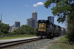
Freight train lines that meet in Indianapolis include one major railroad (CSX Transportation), one medium-sized railroad (Indiana Rail Road Company), and two smaller railroads (Indiana Southern Railroad and Louisville and Indiana Railroad). Indianapolis is a key hub for CSX Transportation, with its main office for the region, an intermodal terminal (where goods switch between different types of transport), and a large train yard in the suburb of Avon.
Highways and Roads
The Indiana Department of Transportation (INDOT) manages all the Interstates, U.S. Highways, and Indiana State Roads within Indianapolis. In 2022, drivers in Indianapolis spent an average of 24 hours stuck in traffic. This was a 71% increase from 2021 but still less than before the COVID-19 pandemic in 2019.
Interstate Highways
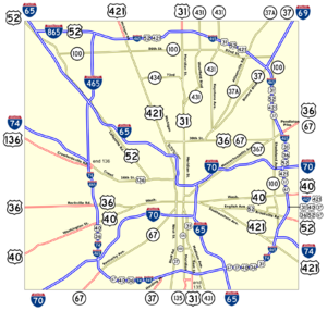
The Indianapolis area has four main Interstate highways and two smaller ones. Interstate 465 (I-465) is a 53-mile (85 km) beltway that circles Indianapolis, connecting all the Interstates in the city.
Among the main Interstates, Interstate 65 (I-65) and Interstate 70 (I-70) are the only two that cut through the city north-south and east-west. I-65 and I-70 meet near downtown Indianapolis in an area sometimes called the "inner loop." The North Split interchange, where these two highways merge northeast of downtown, is the second-busiest interchange in Indiana, with over 200,000 vehicles passing through daily. INDOT began a $350 million project to rebuild this interchange in 2021. I-65 goes north to Gary, Indiana, and south to Louisville, Kentucky. I-70 goes west to St. Louis, Missouri, and east to Columbus, Ohio.
Two other main Interstates serve Indianapolis: Interstate 69 (I-69) and Interstate 74 (I-74). I-69 goes north to Fort Wayne, Indiana. As of December 2022, I-69 ends at I-465 on the city's northeast side. However, construction is underway on the city's south side to finish the last 27-mile (43 km) part of the highway between Martinsville, Indiana, and Indianapolis. Once completed in 2024, I-69 will extend south from Indianapolis to Evansville, Indiana. I-74 comes from Peoria, Illinois, meets I-465 on the city's west side, runs along with I-465 for a bit, then splits off on the city's southeast side toward Cincinnati, Ohio. Interstate 865 (I-865) is a 4.7-mile (7.6 km) connector road between I-65 and I-465, northwest of Indianapolis.
U.S. Highways and State Roads
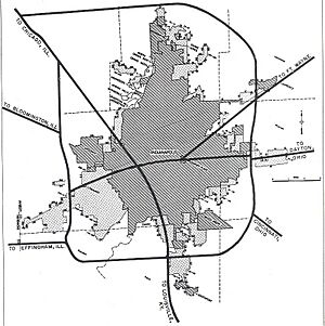
Indianapolis is served by six U.S. Highways and four Indiana State Roads. Starting in 1967, INDOT began changing the routes of U.S. Highways and Indiana State Roads to use the I-465 beltway, helping traffic bypass local areas. By July 1, 1999, INDOT had finished removing the remaining highway sections inside the beltway. These old roads were then given to the Indianapolis Department of Public Works.
US 31 goes north to South Bend, Indiana, and south to Jeffersonville, Indiana. US 36 goes west to Springfield, Illinois, and east to Piqua, Ohio. US 40, also known as the Historic National Road, goes west to Terre Haute, Indiana, and east to Richmond, Indiana. Within Marion County, US 40 is called Washington St.. US 52 goes northwest to Lafayette, Indiana, and southeast to Brookville, Indiana. US 136 goes west to Danville, Illinois, and ends at I-465 on the city's west side near Speedway, Indiana. US 421 goes north to Michigan City, Indiana, and south to Madison, Indiana.
State Road 37 goes south to Tell City, Indiana, and north to Marion, Indiana. State Road 67 (Kentucky Ave.) goes southwest to Vincennes, Indiana, and northeast to Portland, Indiana. State Road 134 is a short 0.38-mile (0.61 km) section of Girls School Rd. that connects the Indiana Women's Prison to US 136 on the city's west side. From its northern end at US 31 on the city's south side, State Road 135 (Meridian St. via Thompson Rd.) ends near Mauckport, Indiana, at the Ohio River.
Getting Around Inside the City
Transportation within Indianapolis includes a local public bus system, a bicycle-sharing system, and a network of bike lanes, trails, and greenways. The city's Department of Public Works takes care of about 8,175 miles (13,156 km) of street lanes, plus alleys, sidewalks, curbs, and 540 bridges.
Bicycling Around Indianapolis

In 2021, Indianapolis had 115 miles (185 km) of bike lanes, plus 116 miles (187 km) of trails and greenways. In recent years, city officials have promised more money for improving and adding bike paths, including the city's first "neighborways" (streets designed to be safer for bikes). Popular trails and greenways in the city include the Fall Creek Greenway, Indianapolis Cultural Trail, Pleasant Run Greenway, and Monon Trail. The Monon Trail is a "rail trail," meaning it was built on an old railroad line, and it's part of the United States Bicycle Route System.
Indiana Pacers Bikeshare started in 2014 as the city's public bicycle-sharing system. It has 525 bicycles and 50 docking stations where you can pick up and drop off bikes. These stations are located on or near the city's public trails and greenways.
Indianapolis has been recognized as a "Bronze Level" Bicycle Friendly Community by the League of American Bicyclists.
Public Bus System
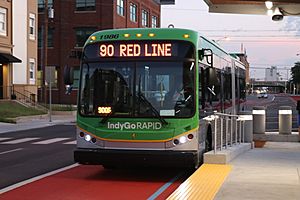
The Indianapolis Public Transportation Corporation, known as IndyGo, runs and manages the city's public bus system. This includes bus rapid transit, microtransit (on-demand shared rides), and paratransit (services for people with disabilities). In 2020, IndyGo operated 31 regular bus routes with a fleet of 212 buses, serving about 4.8 million passenger trips. (Before the COVID-19 pandemic, ridership was higher, at 9.2 million trips in 2019).
IndyGo started operating in 1975 under the name Metro. The Julia M. Carson Transit Center opened in 2016 as the main downtown transfer hub for 27 of its 31 bus routes.
In 2017, the Indianapolis City-County Council approved a vote that increased Marion County's income tax to help pay for IndyGo's first big system expansion since it began. Local taxes and federal grants will fund improvements across the system, including three new bus rapid transit lines, battery electric buses, new sidewalks, bus shelters, and longer hours with weekend schedules.
The Central Indiana Regional Transportation Authority (CIRTA), created in 2007, is a government-like agency that organizes regional car and vanpools. It also runs three public workforce connectors from Indianapolis to job centers in suburban Plainfield and Whitestown. CIRTA serves ten counties around Indianapolis.
Bus Rapid Transit Lines
The first of IndyGo's three bus rapid transit projects, the Red Line, began service on September 1, 2019. The Red Line runs 13.1 miles (21.1 km) north-south from Broad Ripple Village to the University of Indianapolis. The 15.2-mile (24.5 km) Purple Line, the system's second bus rapid transit route, will connect downtown Indianapolis to Lawrence, Indiana. Construction on the Purple Line began on February 25, 2022. The Blue Line is planned to run 24 miles (39 km) east-west from Cumberland, Indiana, to Indianapolis International Airport. Construction on the Blue Line is expected to start in 2024.
Past Streetcars and Future Ideas
Historically, Indianapolis had a large streetcar network. The last streetcars ran in the city in 1953, and trolleybuses stopped four years later. Since 1957, the city's public transit system has only used buses.
There has been interest in bringing back a streetcar system in the city since the 1990s. In 2008, community leaders formed a group to study if a downtown streetcar loop would work. After three years, the group suggested a 2-mile (3.2 km) streetcar loop connecting key attractions on the west side of downtown Indianapolis, estimated to cost $20 to $25 million.
In 2008, the Central Indiana Regional Transportation Authority identified an old railroad line (the former Nickel Plate corridor) between downtown Indianapolis and the northern suburb of Noblesville as the first part of a proposed regional commuter train network.
In 2010, another group, the Central Indiana Transit Task Force, released a $6.7 billion plan with several ideas for the region. These included a north-south commuter rail line between Fishers and Greenwood, and an east-west light rail line along Washington St. between Cumberland and the Indianapolis International Airport.
In 2014, the Indiana General Assembly allowed Indianapolis and five nearby counties to raise local income taxes to fund public transit through a public vote. However, as part of this law, local governments were not allowed to use public money to build light rail projects.
People Mover System
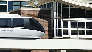
The Indiana University Health People Mover started in 2003. It was a 1.4-mile (2.3 km) elevated train that connected the Indiana University School of Medicine with several medical centers like Methodist Hospital, Riley Hospital for Children, and University Hospital on the Indiana University–Purdue University Indianapolis (IUPUI) campus. It had three elevated stations. Indiana University Health stopped the people mover service in February 2019 because of high maintenance costs. They decided to replace it with bus shuttles instead.
 | Madam C. J. Walker |
 | Janet Emerson Bashen |
 | Annie Turnbo Malone |
 | Maggie L. Walker |


