Adams County, Pennsylvania facts for kids
Quick facts for kids
Adams County
|
||
|---|---|---|
|
||
|
||
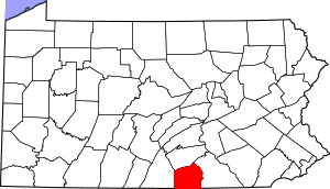
Location within the U.S. state of Pennsylvania
|
||
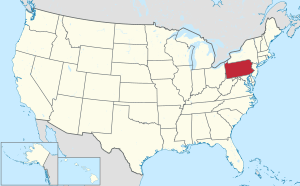 Pennsylvania's location within the U.S. |
||
| Country | ||
| State | ||
| Founded | January 22, 1800 | |
| Named for | John Adams | |
| Seat | Gettysburg | |
| Largest borough | Gettysburg | |
| Area | ||
| • Total | 522 sq mi (1,350 km2) | |
| • Land | 519 sq mi (1,340 km2) | |
| • Water | 3.1 sq mi (8 km2) 0.6%% | |
| Population
(2020)
|
||
| • Total | 103,852 | |
| • Estimate
(2022)
|
106,027 |
|
| • Density | 200/sq mi (80/km2) | |
| Time zone | UTC−5 (Eastern) | |
| • Summer (DST) | UTC−4 (EDT) | |
| Congressional district | 13th | |
|
Pennsylvania Historical Marker
|
||
| Type: | City | |
| Designated: | November 6, 1982 | |
Adams County is a county in Pennsylvania, a state in the United States. In 2020, about 103,852 people lived here. The main town, or county seat, is Gettysburg.
The county was created on January 22, 1800. It was formed from a part of York County. Adams County was named after John Adams, who was the second President of the United States.
A very important battle of the American Civil War happened here. This was the Battle of Gettysburg, fought from July 1 to 3, 1863. Because of this, Adams County is a popular place for people interested in Civil War history. The county is located in the south-central part of Pennsylvania.
Contents
Geography
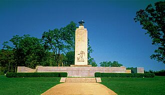
Adams County covers about 522 square miles. Most of this area, 519 square miles, is land. Only a small part, about 3.1 square miles, is water. This is about 0.6% of the total area.
The town of Gettysburg is right in the middle of Adams County. The Gettysburg National Military Park surrounds Gettysburg on three sides. This park protects the historic battlefield. The Eisenhower National Historic Site is also nearby. It was the home of President Dwight D. Eisenhower.
Many of the old roads and natural areas from the 1800s are still here. Thirteen historic roads meet near Gettysburg. There are two circles of towns around Gettysburg. The first circle is about 7 miles away. The second circle is 12 to 15 miles away. This "spokes and wheel" pattern is a rare example of how towns can grow around a main center.
The county's water flows into the Chesapeake Bay. It is drained by the Susquehanna River and the Potomac River.
Nearby Counties
Adams County shares borders with these counties:
- Cumberland County (north)
- York County (east)
- Carroll County, Maryland (southeast)
- Frederick County, Maryland (southwest)
- Franklin County (west)
Protected Natural Areas
These special areas are protected in Adams County:
Climate
Adams County has a climate with hot summers. This means it has warm, humid summers and cold winters.
Fun Things to Do
Adams County has many places for recreation and outdoor activities:
- Caledonia State Park: This state park is named after an old iron furnace. Part of it is in Adams County.
- Eisenhower National Historic Site: You can visit the home and farm of Dwight D. Eisenhower, who was the 34th President of the United States.
- Gettysburg Battlefield: This is where the famous American Civil War battle was fought in July 1863.
- Journey Through Hallowed Ground National Heritage Area: This is a special area that covers parts of Maryland, Pennsylvania, Virginia, and West Virginia. It protects important historical sites.
- McPherson Ridge: This landform was used during the Battle of Gettysburg.
- Michaux State Forest: A large forest area for outdoor activities.
- Pennsylvania State Game Lands Number 249: This area is open for hunting, trapping, and other outdoor fun.
- Strawberry Hill Nature Preserve: A place to enjoy nature and wildlife.
People and Population
| Historical population | |||
|---|---|---|---|
| Census | Pop. | %± | |
| 1800 | 13,172 | — | |
| 1810 | 15,152 | 15.0% | |
| 1820 | 19,370 | 27.8% | |
| 1830 | 21,379 | 10.4% | |
| 1840 | 23,044 | 7.8% | |
| 1850 | 25,981 | 12.7% | |
| 1860 | 28,006 | 7.8% | |
| 1870 | 30,315 | 8.2% | |
| 1880 | 32,455 | 7.1% | |
| 1890 | 33,486 | 3.2% | |
| 1900 | 34,496 | 3.0% | |
| 1910 | 34,319 | −0.5% | |
| 1920 | 34,583 | 0.8% | |
| 1930 | 37,128 | 7.4% | |
| 1940 | 39,435 | 6.2% | |
| 1950 | 44,197 | 12.1% | |
| 1960 | 51,906 | 17.4% | |
| 1970 | 56,937 | 9.7% | |
| 1980 | 68,292 | 19.9% | |
| 1990 | 78,274 | 14.6% | |
| 2000 | 91,292 | 16.6% | |
| 2010 | 101,407 | 11.1% | |
| 2020 | 103,852 | 2.4% | |
| 2022 (est.) | 106,027 | 4.6% | |
| U.S. Decennial Census 1790–1960 1900–1990 1990–2000 2010–2017 |
|||
In 2022, about 106,027 people lived in Adams County. There were about 40,676 households, which are groups of people living together. The county has about 204 people per square mile. Most homes, about 76%, are owned by the people who live in them.
Most adults, about 90.7%, have finished high school. About 24.3% have a college degree or higher. The average income per person was $36,150. The average income for a household was $76,727. About 8.4% of the people lived below the poverty line.
Most people in the county are White (87%). About 1% are Black or African American, and 1% are Asian. About 7% of the population are Hispanic or Latino. About 7.8% of the people have served in the military. About 19% of the population is under 18 years old. About 59% are between 18 and 64, and 22% are 65 or older.
Most households, 68%, are married couples. About 10% have a female head of household with no husband. About 4% have a male head of household with no wife. The average household size is 2.5 people. The average value of a home owned by its residents was $255,900.
Education
Colleges and Universities
- Gettysburg College
- Lutheran Theological Seminary
Community and Technical Colleges
- Harrisburg Area Community College
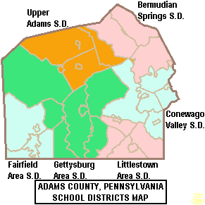
Public School Districts
Students in Adams County attend schools in these districts:
- Bermudian Springs School District
- Conewago Valley School District
- Fairfield Area School District
- Gettysburg Area School District
- Littlestown Area School District
- Upper Adams School District
Public Charter Schools
- Gettysburg Montessori Charter School (for grades K-6)
- Vida Charter School (for grades K-6)
Students in the county can also apply to attend online public cyber charter schools in Pennsylvania.
Private Schools
- Adams County Christian Academy – Gettysburg
- Delone Catholic High School – McSherrystown
- Forest Lane Mennonite School – Gettysburg
- Freedom Christian School – Gettysburg
- Gettysburg Adventist Christian School – Gettysburg
- Indian Acres Amish School - Gettysburg
- JIL Christian School – Biglerville
- Pheasant Cottage Amish School - Littlestown
- St. Francis Xavier School - Gettysburg
- St. Teresa of Calcutta School (Conewago) - Hanover
- St. Teresa of Calcutta School -McSherrystown
Intermediate Unit
The Lincoln Intermediate Unit (IU#12) helps schools in Adams, Franklin, and York counties. It offers special education, helps schools buy things together, and provides technology services. It also has a Summer Academy for gifted students. Other services include training for teachers, adult education, and literacy programs. The Intermediate Unit helps adults earn a high school diploma through a GED program.
Libraries
- A R Wentz Library – Gettysburg
- Adams County Historical Society – Gettysburg
- Carroll Valley Library – Carroll Valley
- Adams County Law Library – Gettysburg
- Adams County Library - Gettysburg
- Harbaugh-Thomas Library – Biglerville
- Jean Barnett Trone Memorial Library of East Berlin – East Berlin
- Littlestown Community Library – Littlestown
- Musselman Library – Gettysburg
- New Oxford Area Library – New Oxford
Transportation
Air Travel
Adams County does not have regular commercial flights. The closest airports with commercial service are in Hagerstown, Maryland (Hagerstown Regional Airport), Harrisburg, Pennsylvania (Harrisburg International Airport), and Lancaster, Pennsylvania (Lancaster Airport).
Bus Service
You can use public bus service in Adams County through the Adams County Transit Authority.
Main Roads
 US 15
US 15
 US 15 Bus.
 US 30
US 30 PA 16
PA 16 PA 34
PA 34 PA 94
PA 94 PA 97
PA 97 PA 116
 PA 134
 PA 194
 PA 233
 PA 234
 PA 394
Communities
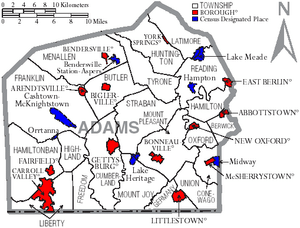
In Pennsylvania, there are different types of towns and areas. These include cities, boroughs, and townships. Here are the main communities in Adams County:
Boroughs
These are incorporated towns with their own local government.
Townships
These are larger areas that often include rural land and smaller communities.
- Berwick
- Butler
- Conewago
- Cumberland
- Franklin
- Freedom
- Germany
- Hamilton
- Hamiltonban
- Highland
- Huntington
- Latimore
- Liberty
- Menallen
- Mount Joy
- Mount Pleasant
- Oxford
- Reading
- Straban
- Tyrone
- Union
Census-Designated Places (CDPs)
These are areas that the U.S. Census Bureau names for collecting data. They are not officially governed towns.
Other Unincorporated Areas
These are smaller communities that are not officially incorporated as boroughs or townships.
- Advance
- Amatus
- Barlow
- Beechersville
- Berlin Junction
- Bermudian
- Bittinger
- Bridgeport
- Brush Run
- Brushtown
- Brysonia
- Cedar Ridge
- Centennial
- Center Mills
- Charnita
- Cross Keys
- Deardorffs Mill
- Edgegrove
- Fairplay
- Five Points
- Floradale
- Fountain Dale
- Gargol
- Georgetown
- Germantown
- Gladhill
- Goldenville
- Green Springs
- Greenmount
- Greenstone
- Guernsey
- Guldens
- Hafer's Mill
- Hershey Heights
- Hilltown
- Indian Village
- Irishtown
- Iron Springs
- Jacks Mountain
- Kingsdale
- Knoxlyn
- Latimore
- Maria Furnace
- Menges Mill
- Mount Hope
- Mount Misery
- Mount Tabor
- Mummasburg
- New Chester
- Oak Grove
- Peach Glen
- Plainview
- Round Hill
- Quaker Valley
- Sedgwick
- Sell
- Seven Stars
- Shanks Mill
- Slate Ridge
- Square Corner
- Stremmels
- The Pines
- Two Taverns
- Virginia Mills
- Waldheim
- Wenksville
- Whitehall
- Zora
Population Ranking of Communities
This table shows the population of the largest communities in Adams County, based on the 2010 census.
† county seat
| Rank | City/town/etc. | Population (2010 Census) | Municipal type | Incorporated |
|---|---|---|---|---|
| 1 | † Gettysburg | 7,620 | Borough | 1806 |
| 2 | Littlestown | 4,434 | Borough | 1864 |
| 3 | Carroll Valley | 3,876 | Borough | 1974 |
| 4 | McSherrystown | 3,038 | Borough | 1882 |
| 5 | Lake Meade | 2,563 | CDP | |
| 6 | Midway | 2,125 | CDP | |
| 7 | Bonneauville | 1,800 | Borough | 1961 |
| 8 | New Oxford | 1,783 | Borough | 1874 |
| 9 | East Berlin | 1,521 | Borough | 1879 |
| 10 | Lake Heritage | 1,333 | CDP | |
| 11 | Biglerville | 1,200 | Borough | 1903 |
| 12 | Abbottstown | 1,011 | Borough | 1835 |
| 13 | Arendtsville | 952 | Borough | 1896 |
| 14 | York Springs | 833 | Borough | 1868 |
| 15 | Heidlersburg | 707 | CDP | |
| 16 | Bendersville | 641 | Borough | 1866 |
| 17 | Hampton | 632 | CDP | |
| 18 | Hunterstown | 547 | CDP | |
| 19 | Fairfield | 507 | Borough | 1896 |
| 20 | Cashtown | 459 | CDP | |
| 21 | Aspers | 350 | CDP | |
| 22 | McKnightstown | 226 | CDP | |
| 23 | Idaville | 177 | CDP | |
| 24 | Orrtanna | 173 | CDP | |
| 25 | Gardners | 150 | CDP | |
| 26 | Table Rock | 62 | CDP | |
| 27 | Floradale | 38 | CDP |
Notable People
Many interesting people have connections to Adams County:
- Joel Funk Asper: A former U.S. Congressman.
- Gabor Boritt: A historian who studied Abraham Lincoln and the American Civil War. He was a professor at Gettysburg College.
- Jake Boritt: A producer who makes documentaries.
- Henry R. Brinkerhoff: A former U.S. Congressman.
- David A. Day: A Lutheran missionary who worked in Liberia.
- Dwight D. Eisenhower and Mamie Eisenhower: They lived in their retirement home near Gettysburg, which is now the Eisenhower National Historic Site.
- Erik Harris: A professional football player who played for the Atlanta Falcons.
- John A. Hauser: A former president of the C. H. Musselman Company.
- Eddie Plank: A famous Major League Baseball pitcher. He is one of the top left-handed pitchers of all time and is in the Baseball Hall of Fame.
- John Studebaker: He helped start the company that became the Studebaker Corporation.
See also
 In Spanish: Condado de Adams (Pensilvania) para niños


