Butler County, Ohio facts for kids
Quick facts for kids
Butler County
|
|||
|---|---|---|---|

|
|||
|
|||

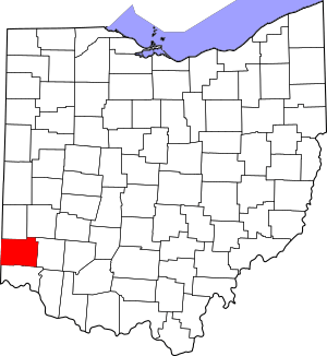
Location within the U.S. state of Ohio
|
|||
 Ohio's location within the U.S. |
|||
| Country | |||
| State | |||
| Founded | May 1, 1803 | ||
| Named for | General Richard Butler | ||
| Seat | Hamilton | ||
| Largest city | Hamilton | ||
| Area | |||
| • Total | 470 sq mi (1,200 km2) | ||
| • Land | 467 sq mi (1,210 km2) | ||
| • Water | 3.1 sq mi (8 km2) 0.7%% | ||
| Population
(2020)
|
|||
| • Total | 390,357 | ||
| • Estimate
(2023)
|
393,043 |
||
| • Density | 831/sq mi (321/km2) | ||
| Time zone | UTC−5 (Eastern) | ||
| • Summer (DST) | UTC−4 (EDT) | ||
| Congressional district | 8th | ||
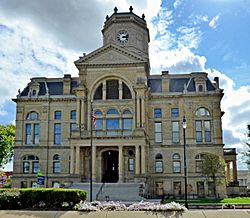
Butler County is a county located in the southwestern part of Ohio. As of 2020, about 390,357 people live here. Its main city and county seat is Hamilton. The county is named after General Richard Butler. He was a general who died in 1791.
The Great Miami River flows through Butler County. The county is also home to Miami University. This is a public university that started in 1809. Butler County is part of the larger Cincinnati metropolitan area.
Contents
History
Long ago, ancient Native American groups lived in this area. They built large mounds and structures from earth. Seven of these amazing earthworks were still standing when they were recorded by a survey.
Early French explorers probably traveled through the area. They would have used the Miami River. White settlers started moving here in larger numbers after 1793. This was when the Treaty of Greenville was signed with the Native American tribes.
Butler County was officially formed on March 24, 1803. It was created from parts of Hamilton County. The county is named after General Richard Butler. Between 1803 and 1823, the different townships in the county were officially recognized. Some land that was first part of Butler County was later moved. It became part of Warren County or Hamilton County. Butler County was originally about 480 square miles in size.
In the late 1860s or early 1870s, something funny happened in the community of Mauds. A local inventor tried to build a mill that would run forever. This is called perpetual motion. A big crowd came to watch the mill start. When it didn't work, everyone laughed. The inventor was never heard from again, and the mill quickly disappeared!
The Great Flood of 1913 caused a lot of damage in the county. It especially affected Middletown, Ohio and Hamilton, Ohio. In Middletown, about a quarter of the town was flooded. Six people died there. In Hamilton, almost half the city was flooded. Over 300 buildings were destroyed, and at least 98 people died.
In 1957, Hueston Woods State Park was created. It covers 3,596 acres in Butler and Preble County. The park has a 625-acre lake made by people. It also has 200 acres of Hueston Woods. This is one of the last nearly untouched forests of American beech and maple trees in Ohio.
Geography and Geology
Butler County covers about 470 square miles. Most of this area is land, with a small part being water.
Most of Butler County is made up of the river valleys. These are the valleys of the Great and Little Miami Rivers. These valleys were originally shaped by glaciers long ago.
The soil on the highest hills is often heavy with clay. As you go downhill, the soil becomes more sandy. In the river valleys, the soil is dark from river deposits. Before settlers cut down many trees, the area was covered in forests. These forests had many American beech and maple trees.
Adjacent Counties
- Preble County (north)
- Montgomery County (northeast)
- Warren County (east)
- Hamilton County (south)
- Dearborn County, Indiana (southwest)
- Franklin County, Indiana (west)
- Union County, Indiana (northwest)
Demographics
| Historical population | |||
|---|---|---|---|
| Census | Pop. | %± | |
| 1810 | 11,150 | — | |
| 1820 | 21,746 | 95.0% | |
| 1830 | 27,142 | 24.8% | |
| 1840 | 28,173 | 3.8% | |
| 1850 | 30,789 | 9.3% | |
| 1860 | 35,840 | 16.4% | |
| 1870 | 39,912 | 11.4% | |
| 1880 | 42,579 | 6.7% | |
| 1890 | 48,597 | 14.1% | |
| 1900 | 56,870 | 17.0% | |
| 1910 | 70,271 | 23.6% | |
| 1920 | 87,025 | 23.8% | |
| 1930 | 114,084 | 31.1% | |
| 1940 | 120,249 | 5.4% | |
| 1950 | 147,203 | 22.4% | |
| 1960 | 199,076 | 35.2% | |
| 1970 | 226,207 | 13.6% | |
| 1980 | 258,787 | 14.4% | |
| 1990 | 291,479 | 12.6% | |
| 2000 | 332,807 | 14.2% | |
| 2010 | 368,130 | 10.6% | |
| 2020 | 390,357 | 6.0% | |
| 2023 (est.) | 393,043 | 6.8% | |
| U.S. Decennial Census 1790-1960 1900-1990 1990-2000 2010-2020 |
|||
2010 Census
In 2010, there were 368,130 people living in Butler County. There were about 135,960 households. A household means all the people living in one home. The population density was about 788 people per square mile.
Most people in the county were white (86.0%). About 7.3% were black or African American. About 2.4% were Asian. People of Hispanic or Latino origin made up 4.0% of the population. Many people had German, American, Irish, or English backgrounds.
About 35.9% of households had children under 18 living with them. The average household had 2.63 people. The average age of people in the county was 36.0 years old.
Education
Butler County has sixteen school districts. These districts serve students across the county.
School Districts in Butler County
- Edgewood City School District (also in Preble)
- Edgewood High School, Trenton (The Cougars)
- Fairfield City School District
- Fairfield High School, Fairfield (The Indians)
- Hamilton City School District
- Hamilton High School, Hamilton (Big Blue)
- Lakota Local School District
- Lakota East High School, Liberty Township (The Thunderhawks)
- Lakota West High School, West Chester (The Firebirds)
- Madison Local School District
- Madison High School, Middletown (The Mohawks)
- Middletown City School District (also in Warren)
- Middletown High School, Middletown (The Middies)
- Monroe Local School District (also in Warren)
- Monroe High School, Monroe (The Hornets)
- New Miami Local School District
- New Miami High School, New Miami (The Vikings)
- Ross Local School District
- Ross High School, Hamilton (The Rams)
- Talawanda City School District (also in Preble)
- Talawanda High School, Oxford (Brave)
Partial School Districts in Butler County
- Mason City School District, Mason OH (Mostly in Warren County)
- Northwest Local School District, Cincinnati OH (Mostly in Hamilton County)
- Preble Shawnee School District, Camden OH (Mostly in Preble County)
- Princeton City School District, Springdale OH (Mostly in Hamilton County)
- Southwest Local School District, Harrison OH (Mostly in Hamilton County)
- Union County–College Corner Joint School District, Liberty IN (Partly in Preble County, Ohio, mostly in Union and Franklin Counties in Indiana)
Private High Schools
- Father Stephen T. Badin High School, (Known as Badin High School), Hamilton (The Rams)
- Cincinnati Christian Schools, Fairfield (The Cougars)
- Middletown Christian Schools, Middletown (The Eagles) (School complex located in Warren County)
Higher Education
Butler County is home to Miami University.
Campuses
- Miami University Main Campus, located in Oxford, OH. It was founded in 1809.
- Miami University Middletown, located in Middletown. This campus started in 1966. It was Ohio's first regional campus.
- Miami University Hamilton, located in Hamilton. This campus was founded in 1968.
- Miami University Voice of America Learning Center, located in West Chester. This campus opened in 2009. It hosts the Farmer School of Business MBA program.
Butler County also has Butler Tech. This is a special school for high school students and adults. It teaches skills for different jobs. Butler Tech has campuses in West Chester and Fairfield Township.
Communities
Cities
- Fairfield
- Hamilton (county seat)
- Middletown
- Monroe
- Oxford
- Sharonville
- Trenton
Villages
Census-designated places
Unincorporated communities
Townships
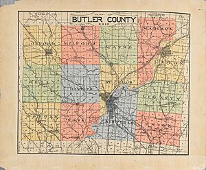
There are thirteen official civil townships in Butler County. There are also three "paper townships." These are areas that exist on maps but don't have their own local government.
Civil Townships
- Fairfield
- Hanover
- Lemon
- Liberty
- Madison
- Milford
- Morgan
- Oxford
- Reily
- Ross
- St. Clair
- Wayne
- West Chester (formerly Union Township)
Paper Townships
- Hamilton
- Heritage (Fairfield)
- Middletown
Ohio House Districts
- Ohio House of Representatives, 51st District
- Ohio House of Representatives, 52nd District
- Ohio House of Representatives, 53rd District
- Ohio House of Representatives, 54th District
Ohio Senate Districts
- Ohio Senate, 4th District
- Ohio Senate, 7th District
Transportation
The Butler County Regional Transit Authority (BCRTA) offers bus service. It runs throughout the county. The main cities served are Hamilton, Oxford, and Middletown. This bus service also connects to the Southwest Ohio Regional Transit Authority.
Notable People
- Walter Alston, manager of Brooklyn/Los Angeles Dodgers baseball team
- Lucky Baldwin, California pioneer and businessman
- John Boehner, congressman, Speaker of the House
- Mary Bowermaster, masters athletics record holder
- James E. Campbell, governor of Ohio
- Cris Carter, football player
- Frank Clair, football player
- Ray Combs, television personality
- Chase Crawford, actor and film producer
- Greg Dulli, musician
- Weeb Ewbank, football coach
- Andrew L. Harris, governor of Ohio
- William Dean Howells, writer
- Lorenzo D. Immell, Medal of Honor recipient in the American Civil War
- Howard Jones, football coach
- Kenesaw Mountain Landis, federal judge and baseball commissioner
- Mark Lewis, baseball player
- Jerry Lucas, basketball player
- McGuire Sisters, musical group
- Ezra Meeker, Oregon Trail preservationist
- Joe Nuxhall, baseball player and radio announcer, both for the Cincinnati Reds
- Darrell Pace, Olympic archer
- Clarence Page, columnist
- Nan Phelps, artist
- Charles Francis Richter, scientist who created the Richter scale for earthquakes
- Charlie Root, baseball player
- Brady Seals, musician
- Kent Tekulve, baseball player
- Roger Troutman, musician
- C. William Verity, politician and businessman
- Scott Walker, musician
- Simon Stepaniak, NFL player for the Green Bay Packers.
See also
 In Spanish: Condado de Butler (Ohio) para niños


