
Carroll County, New Hampshire facts for kids
Quick facts for kids
Carroll County
|
|
|---|---|

|
|

Location within the U.S. state of New Hampshire
|
|
 New Hampshire's location within the U.S. |
|
| Country | |
| State | |
| Founded | 1840 |
| Named for | Charles Carroll of Carrollton |
| Seat | Ossipee |
| Largest town | Conway |
| Area | |
| • Total | 993.5 sq mi (2,573 km2) |
| • Land | 931.9 sq mi (2,414 km2) |
| • Water | 61.6 sq mi (160 km2) 6.2% |
| Population
(2020)
|
|
| • Total | 50,107 |
| • Density | 53.8/sq mi (20.8/km2) |
| Time zone | UTC−5 (Eastern) |
| • Summer (DST) | UTC−4 (EDT) |
| Congressional district | 1st |
Carroll County is a place in New Hampshire, a state in the United States. It is called a county. In 2020, about 50,107 people lived here. This makes it the third-smallest county in New Hampshire by population.
The main town where the county government is located is Ossipee. Carroll County was started in 1840. It was formed from towns that used to be part of Strafford County. The county was named after Charles Carroll of Carrollton. He was the last person to sign the United States Declaration of Independence and passed away in 1832.
Contents
Exploring Carroll County's Geography
Carroll County covers a total area of about 992 square miles. Most of this area, about 931 square miles, is land. The rest, about 61 square miles, is water. This means about 6.2% of the county is covered by water. It is the third-largest county in New Hampshire by its total size.
The northern part of Carroll County is very mountainous. You can find several popular ski areas here. These include Cranmore Mountain, Attitash, King Pine, and Black Mountain. A narrow strip of land in the northwest goes through Crawford Notch. The northern part of this strip is inside Crawford Notch State Park.
Neighboring Counties Around Carroll
Carroll County shares its borders with several other counties:
- Coos County is to the north.
- Oxford County, Maine is to the northeast.
- York County, Maine is to the southeast.
- Strafford County is to the south.
- Belknap County is to the southwest.
- Grafton County is to the west.
Protected Natural Areas
Part of the White Mountain National Forest is located within Carroll County. This forest helps protect important natural areas.
People and Population in Carroll County
The number of people living in Carroll County has changed over time. Here's how the population has grown:
| Historical population | |||
|---|---|---|---|
| Census | Pop. | %± | |
| 1850 | 20,157 | — | |
| 1860 | 20,465 | 1.5% | |
| 1870 | 17,332 | −15.3% | |
| 1880 | 18,224 | 5.1% | |
| 1890 | 18,124 | −0.5% | |
| 1900 | 16,895 | −6.8% | |
| 1910 | 16,316 | −3.4% | |
| 1920 | 15,017 | −8.0% | |
| 1930 | 14,277 | −4.9% | |
| 1940 | 15,589 | 9.2% | |
| 1950 | 15,868 | 1.8% | |
| 1960 | 15,829 | −0.2% | |
| 1970 | 18,548 | 17.2% | |
| 1980 | 27,931 | 50.6% | |
| 1990 | 35,410 | 26.8% | |
| 2000 | 43,666 | 23.3% | |
| 2010 | 47,818 | 9.5% | |
| 2020 | 50,107 | 4.8% | |
| U.S. Decennial Census 1790-1960 1900-1990 1990-2000 2010-2018 |
|||
What the 2010 Census Showed
In 2010, there were 47,818 people living in Carroll County. There were 21,052 households, which are groups of people living together. Also, there were 13,569 families. On average, about 51 people lived in each square mile.
Most people in the county, about 97.5%, were white. Smaller groups included Asian (0.6%), American Indian (0.3%), and Black or African American (0.3%). About 1.0% of the population was of Hispanic or Latino background.
Many people in Carroll County have English ancestry, making up 29.3% of the population. People with Irish ancestry are the second largest group at 24.7%. Those with French ancestry make up 13.8%.
About 24.2% of households had children under 18 living with them. Most households, 52.2%, were married couples. The average age of people in the county was 48.3 years old.
The average income for a household was about $49,897 per year. For families, the average income was about $60,086. About 9.6% of all people in the county lived below the poverty line. This included 14.6% of those under 18.
Towns and Communities in Carroll County
Carroll County has many different towns and smaller communities.
Main Towns in the County
- Albany
- Bartlett
- Brookfield
- Chatham
- Conway
- Eaton
- Effingham
- Freedom
- Hart's Location
- Jackson
- Madison
- Moultonborough
- Ossipee (This is the county seat)
- Sandwich
- Tamworth
- Tuftonboro
- Wakefield
- Wolfeboro
Special Township Area
Designated Places for Census Data
These are specific areas defined for gathering census information:
Other Smaller Communities
These are other places where people live, but they are not officially towns or census-designated places:
- Center Conway
- Chocorua
- East Conway
- East Wakefield
- Eidelweiss
- Ferncroft
- Glen
- Intervale
- Kearsarge
- Lees Mill
- Mirror Lake
- North Sandwich
- Redstone
- Silver Lake
- South Tamworth
- West Ossipee
- Wolfeboro Falls
- Wonalancet
Images for kids
-
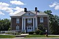
The Carroll County Court House in Ossipee.
See also
 In Spanish: Condado de Carroll (Nuevo Hampshire) para niños
