
Cleveland, Tennessee facts for kids
Quick facts for kids
Cleveland, Tennessee
|
|||||
|---|---|---|---|---|---|

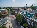
Craigmiles Hall (on the right) in downtown Cleveland
|
|||||
|
|||||
| Nickname(s):
The City with Spirit
|
|||||

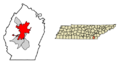
Location of Cleveland in Bradley County, Tennessee.
|
|||||

Cleveland, Tennessee
Location in Tennessee

Cleveland, Tennessee
Location in the United States
|
|||||
| Country | United States | ||||
| State | Tennessee | ||||
| County | Bradley | ||||
| Founded | 1835 | ||||
| Incorporated | 1842 | ||||
| Named for | Benjamin Cleveland | ||||
| Government | |||||
| • Type | City Council | ||||
| Area | |||||
| • Total | 30.87 sq mi (79.96 km2) | ||||
| • Land | 30.86 sq mi (79.94 km2) | ||||
| • Water | 0.01 sq mi (0.02 km2) | ||||
| Elevation | 860 ft (260 m) | ||||
| Population
(2020)
|
|||||
| • Total | 47,356 | ||||
| • Density | 1,534.34/sq mi (592.41/km2) | ||||
| Time zone | UTC−5 (Eastern (EST)) | ||||
| • Summer (DST) | UTC−4 (EDT) | ||||
| ZIP Codes |
37311–37312, 37320, 37323, 37364
|
||||
| Area code(s) | 423 | ||||
| FIPS code | 47-15400 | ||||
| GNIS feature ID | 1280705 | ||||


Cleveland is a city in Tennessee, located in the southeastern part of the state. It is the biggest city and the county seat of Bradley County, Tennessee. In 2020, about 47,356 people lived there. Cleveland is also the main city of the Cleveland metropolitan area, Tennessee, which includes Bradley and Polk County. This area is part of a larger region that includes Chattanooga and Dalton.
Cleveland is the 17th largest city in Tennessee. It has a strong economy, especially in manufacturing. Many big companies, including 13 from the Fortune 500 list, have factories here.
Contents
- Discovering Cleveland's Past: A Journey Through Time
- Cleveland's Location and Landscape
- Cleveland's People and Demographics
- Cleveland's Economy and Tourism
- Arts, Culture, and Fun Events
- Sports in Cleveland
- Parks and Recreation
- Education in Cleveland
- Media in Cleveland
- Cleveland's Transportation and Services
- Notable People from Cleveland
- Sister Cities
- Images for kids
- See also
Discovering Cleveland's Past: A Journey Through Time
Early Days: Native Americans and Explorers
For thousands of years, different groups of indigenous peoples lived in the area where Cleveland is now. Around 900–1000 CE, people from the South Appalachian Mississippian culture built villages along rivers. They often built large earthen mounds for their temples or important homes.
Later, the Cherokee Nation, an Iroquoian-speaking people, lived here. Their main buildings were called townhouses, used for community gatherings. Their land covered parts of North Carolina, South Carolina, Tennessee, Georgia, and Alabama.
The first Europeans to visit this area were likely Spanish explorers led by Hernando de Soto in 1540. They probably camped near Candies Creek in what is now Cleveland. They met some of the Mississippian culture groups.
Cherokee Removal and the City's Founding
After the American Revolutionary War, more European Americans moved into the area. This led to conflicts with the Cherokee people. In 1819, the Cherokee gave up land north of present-day Bradley County to the U.S. government. The Cherokee Agency, which connected the U.S. government and the Cherokee Nation, moved nearby in 1821.
In the 1830s, more settlers arrived, expecting the Cherokee to be moved. In 1830, the Indian Removal Act was passed. In 1832, the Cherokee government moved its center to the Red Clay Council Grounds in southern Bradley County. This lasted until 1838, when the Cherokee were forced to move west. This sad journey is known as the Trail of Tears. Today, Red Clay State Park preserves this historic site.
The forced removal began in 1838. Thousands of Cherokees were gathered and held in camps near Cleveland and Charleston. Fort Cass in Charleston was the main headquarters for the removal.
On February 10, 1836, Bradley County was created. It was named after Colonel Edward Bradley. The county seat was named "Cleveland" after Colonel Benjamin Cleveland, a hero from the American Revolution. The chosen spot for the city was Andrew Taylor's home, known for its good water sources. Cleveland officially became the county seat on January 20, 1838. By then, it had about 400 people, two churches, and a school. The city was officially incorporated on February 4, 1842.
Growth and Industry Before the Civil War
Most early residents of Cleveland were farmers. But by 1850, the city also had many skilled workers and professionals. In 1851, the railroad reached Cleveland, which helped the city grow.
Copper mining began in the Copper Basin in nearby Polk County in the 1840s. The main office for these mining operations was in Cleveland. Copper was brought to Cleveland by wagons and then loaded onto trains. The city's first bank, the Ocoee Bank, opened in 1854.
Cleveland During the Civil War
During the Civil War, Cleveland and most of East Tennessee wanted to stay with the Union. In June 1861, Bradley County voted against Tennessee leaving the Union. Despite this, the Confederate Army occupied Cleveland from June 1861 to late 1863. Local people still supported the Union.
Both Union and Confederate troops often passed through Cleveland, leading to small fights. A sad event was a train wreck near Black Fox, south of Cleveland, which killed 270 Confederate soldiers.
Important Civil War sites in Bradley County include the Henegar House and the Charleston Cumberland Presbyterian Church in Charleston, which were used by both sides. Union troops also camped at Blue Springs Encampments and Fortifications in southern Bradley County.
Cleveland was important because of its railroads. On November 25, 1863, Union cavalry destroyed 12 miles of railroad tracks and a copper factory in Cleveland. This factory was making weapons for the Confederates. This was a big blow to the Confederate army, as they got most of their copper from the nearby mines.
Union troops took control of Cleveland by January 1864 and kept it for the rest of the war. Many Union soldiers camped around Cleveland, preparing for the Atlanta Campaign. They also built two forts, Fort McPherson and Fort Sedgewick, on high points south of downtown. The Civil War caused a lot of damage to Cleveland and the surrounding area.
Rebuilding and New Industries
Cleveland recovered quickly after the Civil War. In the 1870s, it became one of the first cities in Tennessee to develop many industries. The copper mines reopened, and many factories were built. These included the Hardwick Stove Company (1879), the Cleveland Woolen Mills (1880), and the Cleveland Chair Company (1884).
By 1890, Cleveland had many businesses, showing its industrial growth. The city's famous Craigmiles Hall was built in 1878 as an opera house. It is now a well-known landmark.
The city's population more than doubled between 1880 and 1900. Many buildings in the downtown area, now called the Cleveland Commercial Historic District, were built during this time.
Cleveland in the 20th Century
In 1918, the Church of God, a Christian group based in Cleveland, started a Bible school. This school grew into Lee University. In 1933, Bob Jones College, another Christian college, moved to Cleveland. Famous evangelist Billy Graham attended this college for a year in 1936.
After World War II, many large industries moved to Cleveland. The city experienced fast growth in jobs and economy. Factories like Whirlpool, Mallory Battery, and Bendix Corporation were built. Cleveland became one of the biggest manufacturing centers in the Southeastern United States.
In 1966, Cleveland High School was established, and schools in Cleveland began to be integrated. Cleveland State Community College was founded in 1967.
In the 1970s and 1980s, Cleveland gained a reputation for issues related to car sales. The city was sometimes called the "Odometer Rollback Capital of the World" due to problems with car dealerships.
The city also grew in size, adding many nearby neighborhoods and industrial areas. This expansion continued into the late 1990s, making Cleveland much larger.
Recent History and Modern Cleveland
In 1993, Cleveland voters changed the city's government to a council-manager government. In 2012, Cleveland officially adopted the nickname "The City with Spirit." In 2020, a public park was completed at Taylor Spring, where the first settlement of Cleveland began.
In 2024, the Tennessee state legislature named hot slaw the first official state food of Tennessee. Cleveland was named the hot slaw capital of Tennessee.
Cleveland's Location and Landscape
Cleveland is in southeast Tennessee, right in the middle of Bradley County. It sits among low hills and ridges, about 15 miles west of the Blue Ridge Mountains. The Hiwassee River flows north of Bradley County and joins the Tennessee River. The city covers about 30.87 square miles of land.
The area has parallel ridges like Candies Creek Ridge and Blue Springs Ridge, which are part of the Appalachian Mountains. Streams like Candies Creek flow in the valleys between these ridges. The city's elevation ranges from about 700 feet to nearly 1,200 feet.
Downtown Cleveland is the main business district. It has private businesses and government buildings like the Bradley County Courthouse. The areas around downtown, like Stuart Heights and Annadale, are mostly residential.
Northern Cleveland has most of the city's shops and many homes. There is also a large industrial area in the northeast. The western part of the city is almost entirely residential. East and South Cleveland have residential and industrial areas.
Cleveland's Neighborhoods
Cleveland has many different neighborhoods, including:
- Annadale
- Burlington Heights
- North Cleveland
- Windwood
- Fairview
- Sequoia Grove
- Hopewell (partial)
- Centenary Avenue
- Ocoee Street
- Brentwood Estates
- 20th Street NE/Parker Street District
- Blythe Oldfield
- Blueberry Hill
- Rolling Hills
- Laurel Ridge
Cleveland's Climate
Cleveland has a moderate climate. Since 1908, 28 tornadoes have been recorded in the area. Seven of these tornadoes happened on April 27, 2011, during a very large storm system.
| Climate data for Cleveland, Tennessee (1991–2020 normals, extremes 1955–present) | |||||||||||||
|---|---|---|---|---|---|---|---|---|---|---|---|---|---|
| Month | Jan | Feb | Mar | Apr | May | Jun | Jul | Aug | Sep | Oct | Nov | Dec | Year |
| Record high °F (°C) | 76 (24) |
80 (27) |
86 (30) |
91 (33) |
95 (35) |
105 (41) |
105 (41) |
104 (40) |
100 (38) |
97 (36) |
86 (30) |
76 (24) |
105 (41) |
| Mean maximum °F (°C) | 67.8 (19.9) |
71.7 (22.1) |
78.7 (25.9) |
84.2 (29.0) |
88.4 (31.3) |
92.9 (33.8) |
94.9 (34.9) |
94.4 (34.7) |
91.8 (33.2) |
84.4 (29.1) |
75.8 (24.3) |
68.3 (20.2) |
96.0 (35.6) |
| Mean daily maximum °F (°C) | 50.0 (10.0) |
54.6 (12.6) |
62.7 (17.1) |
72.4 (22.4) |
79.5 (26.4) |
86.1 (30.1) |
89.0 (31.7) |
88.4 (31.3) |
83.0 (28.3) |
73.0 (22.8) |
61.3 (16.3) |
52.6 (11.4) |
71.0 (21.7) |
| Daily mean °F (°C) | 39.7 (4.3) |
43.6 (6.4) |
50.8 (10.4) |
59.5 (15.3) |
67.5 (19.7) |
75.1 (23.9) |
78.4 (25.8) |
77.6 (25.3) |
71.6 (22.0) |
60.3 (15.7) |
49.0 (9.4) |
42.4 (5.8) |
59.6 (15.3) |
| Mean daily minimum °F (°C) | 29.4 (−1.4) |
32.6 (0.3) |
38.8 (3.8) |
46.7 (8.2) |
55.6 (13.1) |
64.0 (17.8) |
67.8 (19.9) |
66.8 (19.3) |
60.1 (15.6) |
47.6 (8.7) |
36.7 (2.6) |
32.2 (0.1) |
48.2 (9.0) |
| Mean minimum °F (°C) | 11.0 (−11.7) |
15.2 (−9.3) |
20.8 (−6.2) |
29.5 (−1.4) |
39.6 (4.2) |
52.6 (11.4) |
59.0 (15.0) |
57.6 (14.2) |
45.0 (7.2) |
30.8 (−0.7) |
21.2 (−6.0) |
16.6 (−8.6) |
8.4 (−13.1) |
| Record low °F (°C) | −16 (−27) |
−2 (−19) |
0 (−18) |
20 (−7) |
30 (−1) |
37 (3) |
49 (9) |
47 (8) |
30 (−1) |
21 (−6) |
9 (−13) |
−4 (−20) |
−16 (−27) |
| Average precipitation inches (mm) | 5.20 (132) |
4.88 (124) |
5.56 (141) |
5.01 (127) |
4.58 (116) |
4.90 (124) |
5.14 (131) |
3.84 (98) |
4.67 (119) |
3.52 (89) |
4.85 (123) |
5.47 (139) |
57.62 (1,464) |
| Average snowfall inches (cm) | 0.2 (0.51) |
0.6 (1.5) |
0.0 (0.0) |
0.0 (0.0) |
0.0 (0.0) |
0.0 (0.0) |
0.0 (0.0) |
0.0 (0.0) |
0.0 (0.0) |
0.0 (0.0) |
0.0 (0.0) |
0.3 (0.76) |
1.1 (2.8) |
| Average precipitation days (≥ 0.01 in) | 12.7 | 12.7 | 13.6 | 11.6 | 12.0 | 12.7 | 12.7 | 10.2 | 8.6 | 9.2 | 10.3 | 13.9 | 140.2 |
| Average snowy days (≥ 0.1 in) | 0.3 | 0.4 | 0.0 | 0.0 | 0.0 | 0.0 | 0.0 | 0.0 | 0.0 | 0.0 | 0.0 | 0.2 | 0.9 |
| Source: NOAA | |||||||||||||
Cleveland's People and Demographics
| Historical population | |||
|---|---|---|---|
| Census | Pop. | %± | |
| 1860 | 806 | — | |
| 1870 | 1,658 | 105.7% | |
| 1880 | 1,874 | 13.0% | |
| 1890 | 2,863 | 52.8% | |
| 1900 | 3,858 | 34.8% | |
| 1910 | 5,549 | 43.8% | |
| 1920 | 6,522 | 17.5% | |
| 1930 | 9,136 | 40.1% | |
| 1940 | 11,351 | 24.2% | |
| 1950 | 12,605 | 11.0% | |
| 1960 | 16,196 | 28.5% | |
| 1970 | 21,446 | 32.4% | |
| 1980 | 26,415 | 23.2% | |
| 1990 | 30,354 | 14.9% | |
| 2000 | 37,192 | 22.5% | |
| 2010 | 41,285 | 11.0% | |
| 2020 | 47,356 | 14.7% | |
| U.S. Decennial Census | |||
Cleveland is the main city of the Cleveland metropolitan area, Tennessee. This area includes Bradley and Polk counties. In 2010, about 115,788 people lived in this metropolitan area.
Population Makeup in 2010
In 2010, Cleveland had 41,285 people. Most residents (87.10%) were White. About 7.39% were African American, and 7.52% were Hispanic or Latino (who can be of any race).
About 27.1% of households had children under 18. The average household had 2.40 people. The average family had 2.97 people.
Population Makeup in 2020
| Race / Ethnicity | Pop 2010 | Pop 2020 | % 2010 | % 2020 |
|---|---|---|---|---|
| White alone (NH) | 33,612 | 34,214 | 81.41% | 72.25% |
| Black or African American alone (NH) | 2,975 | 3,779 | 7.21% | 7.98% |
| Native American or Alaska Native alone (NH) | 107 | 130 | 0.26% | 0.27% |
| Asian alone (NH) | 618 | 825 | 1.50% | 1.74% |
| Pacific Islander alone (NH) | 31 | 85 | 0.08% | 0.18% |
| Some Other Race alone (NH) | 57 | 185 | 0.14% | 0.39% |
| Mixed Race/Multi-Racial (NH) | 779 | 2,830 | 1.89% | 5.34% |
| Hispanic or Latino (any race) | 3,106 | 5,608 | 7.52% | 11.84% |
| Total | 41,285 | 47,356 | 100.00% | 100.00% |
In 2020, Cleveland's population grew to 47,356 people.
Religious Life in Cleveland

Cleveland is in the "Bible Belt" region of the Southern United States. Many Protestant Christian groups have churches here. Several Pentecostal groups even have their international headquarters in Cleveland. These include:
- Church of God (and its school, Lee University)
- Church of God of Prophecy
- The Church of God (Charleston, Tennessee)
- The Church of God for All Nations
- The Church of God (Jerusalem Acres)
- The Church of God under the leadership of Bishop James C. Nabors
Bradley County has about 200 Protestant churches and one Roman Catholic church. Some churches in Downtown Cleveland have beautiful architecture. The Broad Street United Methodist Church, First Presbyterian Church, and St. Luke's Episcopal Church are all listed on the National Register of Historic Places.

Cleveland is also home to the famous Craigmiles Mausoleum. It is located behind St. Luke's Episcopal Church. The mausoleum holds the body of Nina Craigmiles, a seven-year-old girl who died in 1871. Her father built the church and mausoleum in her memory. Red stains have mysteriously appeared on the marble of the mausoleum over the years. Even when the marble is replaced, the stains come back.
Cleveland's Economy and Tourism

Cleveland is a major center for industry and manufacturing in Tennessee. It ranks fifth in the state for the number of factories. Companies here make many different products. These include cooking equipment, food, textiles, furniture, batteries, medicines, and car parts.
Some of the top employers are Whirlpool, Johnston Coca-Cola, Mars, Inc., Procter & Gamble, and Duracell. In total, Cleveland has over 150 manufacturing companies. Thirteen of these are Fortune 500 companies.
Cleveland is also the headquarters for Life Care Centers of America, a large nursing facility company. Check Into Cash Inc., a big payday loan company, was founded here in 1993. Hardwick Clothes, America's oldest tailor-made clothing maker, has been based in Cleveland since 1880.
The city also has many retail stores, mostly in the northern part. Bradley Square Mall is a shopping mall with over 50 stores.
Tourism in Cleveland
Tourism is important to Cleveland's economy. Many visitors come to enjoy the outdoors. The Cherokee National Forest in Polk County offers activities like rafting on the Ocoee and Hiwassee rivers. The Ocoee River was even used for the canoe slalom events during the 1996 Summer Olympics in Atlanta.
Red Clay State Park is a historical site near the Georgia border. The Cherokee held important meetings here. The Museum Center at Five Points is a history museum that shows exhibits about the local area. The Ocoee Regional Nature Center is a special arboretum with over 100 types of trees and plants.
Arts, Culture, and Fun Events

The MainStreet Cleveland Halloween Block Party is a very popular event. It attracts over 20,000 people each year. It started in 1988 as a small candy handout. Now, it features live music, food, and a costume contest. In 2015, Cleveland's mayor called the city the "Halloween capital of the world."
Cleveland is also known for Tall Betsy, the "Halloween goblin of Bradley County." For many years, Tall Betsy's appearance on Halloween night brought huge crowds. This inspired the Halloween Block Party. The legend of Tall Betsy goes back to the 19th century.
The Cleveland Apple Festival started in 2002. It is an annual family event held in October. It has art and craft shows, live bluegrass music, food, pony rides, and activities for children. Children can participate in the kids' area activities for free.
The city song is "The Diplomat," composed by John Philip Sousa. It was first performed in Cleveland in 1906. In November 2017, the city celebrated its 175th anniversary.
Sports in Cleveland
Cleveland does not currently have any professional sports teams. However, it used to have two minor league baseball teams: the Cleveland Counts (1911-1913) and the Cleveland Manufacturers (1921-1922).

Cleveland High School has a very successful football program. They hold the second-longest winning streak in Tennessee high school football history, with 54 wins in a row from 1993 to 1996. The Blue Raiders have also won state championships in 1968, 1993, 1994, and 1995.
The wrestling teams from Cleveland High and Bradley Central High are also very strong. Since 1994, the Bradley Central Bears have won many state championships. The Cleveland Blue Raiders, who train at the modern Jones Wrestling Center, have also won many state championships, including recently in 2022, 2023, and 2024.
In 2013, the Cleveland City Council honored the Cleveland High School wrestling team. They declared February 25 as "Blue Raider Wrestling Day."
Parks and Recreation
Cleveland has several public parks for recreation. They are managed by the Cleveland Parks and Recreation department. These parks offer various activities and host organized sports. The Cleveland/Bradley County Greenway is a 4.4-mile path that follows South Mouse Creek.
Other parks and facilities include Bradley County Park, Kenneth L. Tinsley Park, Greenway Park, Mosby Park, Deer Park, College Hill Recreation Center, Johnston Park, Leonard Fletcher Park, Taylor Spring Park, Cleveland Family YMCA, and the South Cleveland Community Center.
Education in Cleveland

Cleveland has three public high schools: Cleveland High School, Bradley Central High School, and Walker Valley High School. There are also three middle schools: Cleveland Middle, Ocoee Middle, and Lake Forest. Cleveland City Schools serves students living within the city limits. Some schools run by Bradley County Schools are also in the city. Tennessee Christian Preparatory School is a private Christian school.
For higher education, Cleveland is home to Cleveland State Community College and Lee University. Lee University is the second-largest private, four-year university in Tennessee.
Public Schools
High Schools
- Cleveland High School
- Bradley Central High School
- Walker Valley High School
- Teen Learning Center
Private Schools
- Tennessee Christian Preparatory School
- Cleveland Christian School
- Candies Creek Academy
- Bowman Hills Adventist School
- Shenandoah Baptist Academy
- United Christian Academy
- Vanguard Christian Academy
Higher Education
- Cleveland State Community College
- Lee University
- Pentecostal Theological Seminary
- Church of God School of Ministry
Media in Cleveland
Newspapers
The Cleveland Daily Banner is the city's local newspaper. It was first published in 1854. The Chattanooga Times Free Press, based in Chattanooga, also provides news for Bradley County residents.
Radio Stations
Several radio stations serve Cleveland. Some are licensed to Cleveland itself:
| Call sign | Frequency | Format |
|---|---|---|
| W207C1 (WAYW) | 89.3 FM | WAY-FM, Contemporary Christian |
| WSAA | 93.1 FM | Air 1, Contemporary Christian |
| WALI | 97.1 FM | Lite rock |
| WOOP-LP | 99.9 FM | Bluegrass |
| WUSY | 100.7 FM | Country |
| W267BI | 101.3 FM | Talk |
| WCLE-FM | 104.1 FM | Adult contemporary |
| W290CA (WTSE) | 105.9 FM | Contemporary Christian |
| WBAC | 1340 AM | News/Talk |
| WCLE-AM | 1570 AM | Talk |
Television Stations
Cleveland is served by TV stations from both Cleveland and nearby cities. Stations licensed in Cleveland include:
| Call sign | Channel | Network |
|---|---|---|
| WPDP-CD | 25 | ABC, Fox, My Network TV |
| WTNB-CD | 27 | Heartland |
| WFLI-TV | 42, 53 | The CW, Me-TV |
Cleveland's Transportation and Services
Getting Around: Transportation

Air Travel
The main airport for Cleveland is the Cleveland Regional Jetport. It opened in 2013 and has a 6,200-foot runway.
Rail Service
The Norfolk Southern Railway serves Cleveland, helping industries transport goods. Passenger trains used to run through Cleveland until the late 1960s and early 1970s.
Roads and Highways
Cleveland's center is where U.S. Route 11 and U.S. Route 64 meet. U.S. 11 connects Cleveland to Chattanooga (south) and Athens (north). The U.S. 11 Bypass helps traffic go around downtown. U.S. Route 64 connects Cleveland to Murphy, North Carolina (east), and the Chattanooga area (southwest).
State Route 60 connects Cleveland to Dayton (northwest) and Dalton, Georgia (southeast). State Route 74 goes south to Chatsworth, Georgia. APD-40 acts as a beltway around the business district. Paul Huff Parkway is a major road in the northern part of the city. Interstate 75 passes through western Cleveland, connecting it to Knoxville (north) and Chattanooga (south). I-75 has three exits in the city.
Main Highways in Cleveland

 Interstate 75
 US 11
US 11 US 64
US 64
US 64 Bypass
US 11 Bypass US 74
US 74 SR 60
SR 60 SR 74
SR 74- Paul Huff Parkway
Other Important Roads
- Mouse Creek Road
- Stuart Road
- Peerless Road
- Georgetown Road
 SR 312 (Harrison Pike)
- Freewill Road
- 20th Street NE
- 17th Street NW
- Michigan Avenue Road
- Benton Pike
- Blue Springs Road
- McGrady Drive
Public Transportation
The Cleveland Urban Area Transit System (CUATS) is a bus service that operates within Cleveland and parts of Bradley County. A Greyhound bus station is also located in the city.
Healthcare Services
Cleveland has two hospitals: Bradley Memorial Hospital and Cleveland Community Hospital. Both are part of Tennova Healthcare. Bradley Healthcare & Rehabilitation Center is a nursing home. Bradley County Emergency Medical Services (EMS) provides emergency medical care.
City Utilities
Cleveland Utilities provides electricity, water, and sewage services to residents. They get water from the Hiwassee and Tennessee Rivers and a spring. They buy electricity from the Tennessee Valley Authority. Natural gas is provided by Chattanooga Gas.
Notable People from Cleveland
Sister Cities
 Phnom Penh, Cambodia
Images for kids
-
Craigmiles Hall (on the right) in downtown Cleveland
-

Flag of Cleveland, Tennessee
-
Seal of Cleveland, Tennessee
-
Logo of Cleveland, Tennessee
-
Location of Cleveland in Bradley County, Tennessee.
See also
 In Spanish: Cleveland (Tennessee) para niños
