Douglas County, Missouri facts for kids
Quick facts for kids
Douglas County
|
|
|---|---|

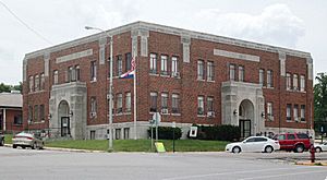
Douglas County courthouse in Ava
|
|

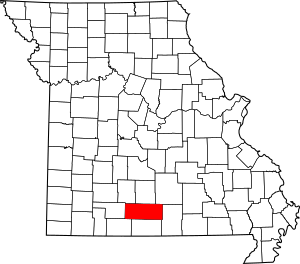
Location within the U.S. state of Missouri
|
|
 Missouri's location within the U.S. |
|
| Country | |
| State | |
| Founded | October 19, 1857 |
| Named for | Stephen A. Douglas |
| Seat | Ava |
| Largest city | Ava |
| Area | |
| • Total | 815 sq mi (2,110 km2) |
| • Land | 814 sq mi (2,110 km2) |
| • Water | 1.0 sq mi (3 km2) 0.1% |
| Population
(2020)
|
|
| • Total | 11,578 |
| • Density | 14.206/sq mi (5.485/km2) |
| Time zone | UTC−6 (Central) |
| • Summer (DST) | UTC−5 (CDT) |
| Congressional district | 8th |
Douglas County is a county located in the south-central part of Missouri, a state in the United States. In 2020, about 11,578 people lived here. The main town and county seat is Ava.
Douglas County was officially started on October 19, 1857. It is named after Stephen A. Douglas, who was a U.S. Senator from Illinois. He was also a candidate for president.
Contents
History of Douglas County
Before Ava became the county seat, the main government office was in a town called Arno. Even before Arno, the county seat was Vera Cruz. Vera Cruz used to be called Red Bud. It is located along Bryant Creek, which flows through the middle of the county.
During the American Civil War, a battle happened near Vera Cruz. It was called the Battle of Clark's Mill and took place on November 7, 1862. The Confederate side won this battle.
After the Civil War, there was a lot of confusion. A group from the western part of the county took the records from the Arno courthouse. They moved them back to Vera Cruz. Later, in 1871, a new town was chosen for the county seat. This new town was Ava, where it is today. Ava was chosen because it was a good location for most people in Douglas County.
Geography of Douglas County
Douglas County covers a total area of 815 square miles. Most of this area, 814 square miles, is land. Only about 1.0 square mile (0.1%) is water.
Counties Nearby
Douglas County shares borders with these counties:
- Webster County (to the northwest)
- Wright County (to the north)
- Texas County (to the northeast)
- Howell County (to the east)
- Ozark County (to the south)
- Taney County (to the southwest)
- Christian County (to the west)
Main Roads
These are the important highways that go through Douglas County:
Protected Natural Areas
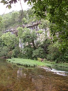
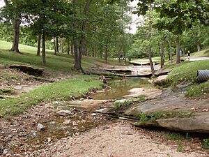
Part of the Mark Twain National Forest is located in Douglas County. This is a large area of protected forest land.
People of Douglas County
| Historical population | |||
|---|---|---|---|
| Census | Pop. | %± | |
| 1860 | 2,414 | — | |
| 1870 | 3,915 | 62.2% | |
| 1880 | 7,753 | 98.0% | |
| 1890 | 14,111 | 82.0% | |
| 1900 | 16,802 | 19.1% | |
| 1910 | 16,664 | −0.8% | |
| 1920 | 15,436 | −7.4% | |
| 1930 | 13,959 | −9.6% | |
| 1940 | 15,600 | 11.8% | |
| 1950 | 12,638 | −19.0% | |
| 1960 | 9,653 | −23.6% | |
| 1970 | 9,268 | −4.0% | |
| 1980 | 11,594 | 25.1% | |
| 1990 | 11,876 | 2.4% | |
| 2000 | 13,084 | 10.2% | |
| 2010 | 13,684 | 4.6% | |
| 2020 | 11,578 | −15.4% | |
| U.S. Decennial Census 1790-1960 1900-1990 1990-2000 2010-2015 |
|||
In 2000, there were 13,084 people living in Douglas County. The population density was about 16 people per square mile. Most people in the county were White (96.86%). About 0.84% of the population was Hispanic or Latino.
The average household had about 2.49 people. The average family had about 2.99 people. About 25.80% of the people were under 18 years old. The median age was 40 years.
Religion in Douglas County
Many people in Douglas County are Protestant Christians. Some of the main groups include Southern Baptists and the Church of the Nazarene.
A special place in the county is Assumption Abbey. It is a Trappist monastery established in 1950. It is located on 3,000 acres in the Ozark hills. There is also a nearby Friary called Our Lady of the Angels. Both places offer rooms for visitors who want a quiet place to reflect.
Education in Douglas County
Most adults in Douglas County (about 69.7%) have a high school diploma or higher. About 9.9% have a bachelor's degree or higher.
Public Schools
Douglas County has several public school districts:
- Ava R-I School District in Ava
- Ava Elementary School (Pre-Kindergarten to 4th grade)
- Ava Middle School (5th to 8th grade)
- Ava High School (9th to 12th grade)
- Plainview R8 School District in Goodhope, Missouri
- Plainview Elementary School (Kindergarten to 8th grade)
- Skyline R2 School District in Norwood, Missouri
- Skyline Elementary (Kindergarten to 8th grade)
Private Schools
- Mt. Zion Bible Academy in Ava (Pre-Kindergarten to 12th grade). This school is associated with the Church of God.
Public Libraries
The Douglas County Public Library serves the community.
Communities in Douglas County
Douglas County has one official town, Ava, which is the county seat. Many other communities, both current and historic, are also found here:
- Ann
- Arden
- Arno
- Ava
- Basher
- Bertha
- Biggs
- Blanche
- Brushyknob
- Bryant
- Buckhart
- Champion
- Cheney
- Coldspring
- Cross Roads
- Denlow
- Depew
- Dogwood
- Drury
- Evans
- Fielden
- Filer
- Gentryville
- Girdner
- Goodhope
- Granada
- Hebron
- Hest
- Jackson Mill
- Merritt
- Midway
- Mount Zion
- Olathia
- Ongo
- Pansy
- Prior
- Red Bank
- Richville
- Rippee
- Rome
- Roosevelt
- Roy
- Smallett
- Squires
- Sweden
- Tigris
- Topaz
- Vanzant
- Vera Cruz
- Witty
See also
 In Spanish: Condado de Douglas (Misuri) para niños
 | Delilah Pierce |
 | Gordon Parks |
 | Augusta Savage |
 | Charles Ethan Porter |


