
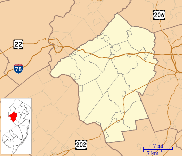
Image: Location map of Hunterdon County, New Jersey

Size of this PNG preview of this SVG file: 700 × 600 pixels. Other resolution: 280 × 240 pixels.
Original image (SVG file, nominally 896 × 768 pixels, file size: 410 KB)
Description: This is a map of Hunterdon County, New Jersey, USA which includes incorporated settlements, township borders, and major highways.
Title: Location map of Hunterdon County, New Jersey
Credit: My own work, using custom-written MapScript applications with United States Census Bureau data
Author: Omnedon
Usage Terms: Public domain
License: Public domain
Attribution Required?: No
Image usage
More than 100 pages link to this image. The following list shows the first 100 page links to this image only. A full list is available.
- Alexandria Township, New Jersey
- Alexauken, New Jersey
- Allens Corner, New Jersey
- Allerton, New Jersey
- Amsterdam, New Jersey
- Amwell, New Jersey
- Anthony, New Jersey
- Baptistown, New Jersey
- Barbertown, New Jersey
- Barley Sheaf, New Jersey
- Bethlehem Township, New Jersey
- Bloomsbury, New Jersey
- Bowne, New Jersey
- Bunnvale, New Jersey
- Buttonwood Corners, New Jersey
- Byram, New Jersey
- Califon, New Jersey
- Centerville, Hunterdon County, New Jersey
- Charlestown, New Jersey
- Cherryville, New Jersey
- Clarksville, Hunterdon County, New Jersey
- Clinton, New Jersey
- Cloverhill, New Jersey
- Cokesbury, New Jersey
- Copper Hill, New Jersey
- Croton, New Jersey
- Cushetunk Mountain
- Darts Mills, New Jersey
- Dreahook, New Jersey
- East Amwell Township, New Jersey
- Everittstown, New Jersey
- Fairmount, New Jersey
- Finesville, New Jersey
- Flemington, New Jersey
- Flemington Historic District
- Flemington Junction, New Jersey
- Frenchtown, New Jersey
- Glen Gardner, New Jersey
- Grandin, New Jersey
- Hamden, New Jersey
- Hampton, New Jersey
- Headquarters, New Jersey
- High Bridge, New Jersey
- Highfields (Amwell and Hopewell, New Jersey)
- Hoffmans, New Jersey
- Holland Township, New Jersey
- Hughesville, New Jersey
- Idell, New Jersey
- Jutland, New Jersey
- Kingwood Township, New Jersey
- Lambertville, New Jersey
- Lansdowne, New Jersey
- Larisons Corners, New Jersey
- Lebanon, New Jersey
- Little York, Hunterdon County, New Jersey
- Locktown, New Jersey
- Lower Valley, New Jersey
- McCrea Mills, New Jersey
- McPherson, New Jersey
- Mechanicsville, Hunterdon County, New Jersey
- Mount Airy, New Jersey
- Mount Pleasant, Hunterdon County, New Jersey
- Mountainville, New Jersey
- New Hampton, New Jersey
- Norton, New Jersey
- Oldwick, New Jersey
- Pattenburg, New Jersey
- Penwell, New Jersey
- Perryville, New Jersey
- Pierce Heights, New Jersey
- Pittstown, New Jersey
- Pleasant Run, New Jersey
- Potterstown, New Jersey
- Pottersville, New Jersey
- Prallsville, New Jersey
- Quakertown, New Jersey
- Raven Rock, New Jersey
- Readington Township, New Jersey
- Readington Village, New Jersey
- Reaville, New Jersey
- Rileyville, New Jersey
- Ringoes, New Jersey
- Rockefellows Mills, New Jersey
- Rosemont, Hunterdon County, New Jersey
- Rowland's Mills, New Jersey
- Sand Brook, New Jersey
- Sandy Ridge, New Jersey
- Scrappy Corner, New Jersey
- Sergeantsville, New Jersey
- Snydertown, New Jersey
- Stanton, New Jersey
- Stockton, New Jersey
- Tewksbury Township, New Jersey
- Three Bridges, New Jersey
- Tumble Falls, New Jersey
- Unionville, New Jersey
- Van Syckel, New Jersey
- Vanlieu Corners, New Jersey
- Voorhees Corner, New Jersey
- Wertsville, New Jersey

All content from Kiddle encyclopedia articles (including the article images and facts) can be freely used under Attribution-ShareAlike license, unless stated otherwise.