
List of waterfalls in Canada facts for kids
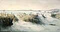
Canada is a land of incredible natural beauty, and its waterfalls are truly spectacular! From towering cascades that drop hundreds of meters to powerful rivers that rush over wide ledges, there's a huge variety of waterfalls to explore. This list will introduce you to some of Canada's most famous and impressive waterfalls, whether they're known for their height, their incredible water flow, or just being a special spot in their province. Get ready to discover the wonders of Canada's falling waters!
Contents
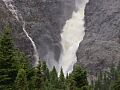
Canada's Tallest Waterfalls
It's tricky to measure the exact height of a waterfall, so there's no single "right" way to do it. This means that the numbers you see are often estimates, and the order of waterfalls on a list might change depending on how they were measured. Don't worry too much about the exact ranking, just enjoy learning about these amazing natural wonders!
Waterfalls by Total Height
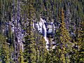
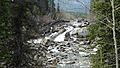
As of 2020, Canada has 18 waterfalls that are at least 400 meters (about 1,312 feet) tall. Most of these giants are found in British Columbia!
| Waterfall | Image | Height (meters) | Height (feet) | Province | Location |
|---|---|---|---|---|---|
| James Bruce Falls | 840 | 2,756 | British Columbia | 50°13′08″N 123°46′57″W / 50.2189°N 123.7825°W | |
| Madden Falls | 579 | 1,899 | British Columbia | 49°53′20″N 123°19′01″W / 49.8889°N 123.3170°W | |
| Swiftcurrent Falls | 537 | 1,762 | British Columbia | 53°07′49″N 119°19′03″W / 53.1304°N 119.3176°W | |
| Kingcome Valley Falls | 520 | 1,706 | British Columbia | 51°16′10″N 126°12′46″W / 51.2695°N 126.2128°W | |
| Schwartzenbach Falls | 520 | 1,706 | Nunavut | 66°30′30″N 65°31′30″W / 66.5083°N 65.5250°W | |
| Francis Falls | 518 | 1,699 | British Columbia | 50°39′33″N 124°11′47″W / 50.6591°N 124.1965°W | |
| Storey Peak Falls | 480 | 1,575 | British Columbia | 50°00′17″N 123°21′53″W / 50.0047°N 123.3648°W | |
| Cerberus Falls | 475 | 1,558 | British Columbia | 51°53′39″N 117°04′19″W / 51.8941°N 117.0720°W | |
| Kiwi Falls | 475 | 1,558 | British Columbia | 50°09′18″N 126°12′44″W / 50.1549°N 126.2122°W | |
| Bush Mountain Falls | 466 | 1,529 | British Columbia | 51°49′22″N 117°08′01″W / 51.8228°N 117.1335°W | |
| Unnamed waterfall | 460 | 1,509 | British Columbia | 51°17′56″N 125°44′16″W / 51.2989°N 125.7378°W | |
| Bedard Falls | 457 | 1,499 | British Columbia | 49°58′53″N 123°20′49″W / 49.9815°N 123.3469°W | |
| Unnamed waterfall | 457 | 1,499 | British Columbia | 50°18′45″N 123°56′09″W / 50.3124°N 123.9357°W | |
| Harmony Falls | 444 | 1,457 | British Columbia | 49°51′23″N 123°59′55″W / 49.8565°N 123.9985°W | |
| Michael Falls | 442 | 1,450 | British Columbia | 51°28′25″N 116°31′07″W / 51.4736°N 116.5186°W | |
| Della Falls | 440 | 1,444 | British Columbia | 49°27′16″N 125°32′11″W / 49.4544°N 125.5363°W | |
| South Phillips Glacier Falls | 427 | 1,401 | British Columbia | 53°07′24″N 119°13′23″W / 53.1232°N 119.2230°W | |
| Bishop Falls | 410 | 1,345 | British Columbia | 58°40′31″N 133°27′12″W / 58.6753°N 133.4534°W |
.jpg)


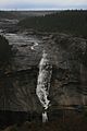
Waterfalls by Tallest Single Drop
Some waterfalls fall in stages, but others have one long, unbroken drop. As of 2020, 14 waterfalls in Canada have a single drop of at least 150 meters (about 492 feet).
| Waterfall | Image | Height (meters) | Height (feet) | Province | Location |
|---|---|---|---|---|---|
| Cerberus Falls | 475 | 1,558 | British Columbia | 51°53′39″N 117°04′19″W / 51.8941°N 117.0720°W | |
| Odegaard Falls | 271 | 889 | British Columbia | 52°14′29″N 126°17′33″W / 52.2415°N 126.2924°W | |
| Hunlen Falls | 260 | 853 | British Columbia | 52°16′36″N 125°46′21″W / 52.2768°N 125.7724°W | |
| Takakkaw Falls | 260 | 853 | British Columbia | 51°30′00″N 116°28′23″W / 51.5001°N 116.4730°W | |
| Hamill Creek Falls | 255 | 837 | British Columbia | 50°14′24″N 116°35′06″W / 50.2401°N 116.5851°W | |
| Pissing Mare Falls | 255 | 837 | Newfoundland and Labrador | 49°42′37″N 57°39′39″W / 49.7104°N 57.6609°W | |
| Francis Falls | 244 | 801 | British Columbia | 50°39′33″N 124°11′47″W / 50.6591°N 124.1965°W | |
| South Phillips Glacier Falls | 244 | 801 | British Columbia | 53°07′24″N 119°13′23″W / 53.1232°N 119.2230°W | |
| Middle Cummins Falls | 220 | 722 | British Columbia | 52°10′00″N 117°59′25″W / 52.1667°N 117.9904°W | |
| Schwartzenbach Falls | 200 | 656 | Nunavut | 66°30′30″N 65°31′30″W / 66.5083°N 65.5250°W | |
| Michael Falls | 158 | 518 | British Columbia | 51°28′25″N 116°31′07″W / 51.4736°N 116.5186°W | |
| Bow Glacier Falls | 154 | 505 | Alberta | 51°39′12″N 116°29′57″W / 51.6532°N 116.4992°W | |
| Lady Wilsons Falls | 152 | 499 | Alberta | 52°01′37″N 116°49′00″W / 52.0269°N 116.8167°W | |
| Madden Falls | 152 | 499 | British Columbia | 49°53′20″N 123°19′01″W / 49.8889°N 123.3170°W |


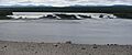
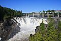
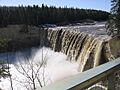
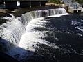
Waterfalls by Average Flow Rate
The "flow rate" of a waterfall tells us how much water rushes over it every second. It's like measuring how much water fills a swimming pool in a certain amount of time! Waterfalls with high flow rates are incredibly powerful and often very wide.
As of 2021, there are 25 waterfalls in Canada with an average flow rate of at least 100 cubic meters per second (about 3,531 cubic feet per second).
| Waterfall | Image | Flow Rate (m³/s) | Flow Rate (ft³/s) | Province | Location |
|---|---|---|---|---|---|
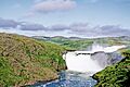
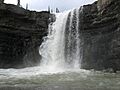
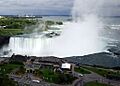
| Niagara Falls | 2407 | 85000 | Ontario / New York (U.S.) | 43°04′38″N 79°04′32″W / 43.077305°N 79.07562°W | |
| Vermilion Falls | 1812 | 64000 | Alberta | 58°22′11″N 114°52′18″W / 58.36972°N 114.87176°W | |
| Limestone Falls | 1464 | 51700 | Quebec | 57°28′45″N 69°18′36″W / 57.4791°N 69.3099°W | |
| Pyrite Falls | 1464 | 51700 | Quebec | 57°26′00″N 69°14′32″W / 57.4333°N 69.2422°W | |
| Virginia Falls | 1000 | 35300 | Northwest Territories | 61°36′26″N 125°44′12″W / 61.60722°N 125.73667°W | |
| Shale Falls | 934 | 33000 | Quebec | 56°44′39″N 69°01′04″W / 56.7443°N 69.0179°W | |
| Chaudière Falls | 500 | 17700 | Quebec | 46°42′53″N 71°16′57″W / 46.71472°N 71.28250°W | |
| Granite Falls | 453 | 16000 | Quebec | 55°50′42″N 68°25′25″W / 55.8450°N 68.4235°W | |
| Little Eaton Canyon Falls | 317 | 11200 | Quebec | 55°31′46″N 68°17′40″W / 55.5294°N 68.2945°W | |
| Lower Eaton Canyon Falls | 317 | 11200 | Quebec | 55°33′46″N 68°11′50″W / 55.5627°N 68.1973°W | |
| Nastapoca Falls | 317 | 11200 | Quebec | 56°54′54″N 76°31′46″W / 56.915004°N 76.529509°W | |
| Tuktu Falls | 317 | 11200 | Quebec | 55°32′36″N 68°14′44″W / 55.5432°N 68.2456°W | |
| Twin Falls | 317 | 11200 | Quebec | 56°53′54″N 76°24′12″W / 56.8984°N 76.4032°W | |
| Upper Eaton Canyon Falls | 317 | 11200 | Quebec | 55°33′29″N 68°12′57″W / 55.5581°N 68.2158°W | |
| Alexandra Falls | 282 | 9960 | Northwest Territories | 60°30′02″N 116°16′45″W / 60.50056°N 116.27917°W | |
| Louise Falls | 282 | 9960 | Northwest Territories | 60°30′12″N 116°14′29″W / 60.5033°N 116.2414°W | |
| Rearguard Falls | 171 | 6040 | British Columbia | 52°58′24″N 119°21′51″W / 52.97333°N 119.3641°W | |
| Montmorency Falls | 130 | 4590 | Quebec | 46°53′27″N 71°8′51″W / 46.89083°N 71.14750°W | |
| Baileys Chute | 122 | 4310 | British Columbia | 52°04′19″N 120°11′33″W / 52.07204°N 120.19255°W | |
| Marcus Falls | 122 | 4310 | British Columbia | 52°04′28″N 120°12′00″W / 52.0744°N 120.1999°W | |
| Athabasca Falls | 113 | 3990 | Alberta | 52°39′51″N 117°53′01″W / 52.66417°N 117.88361°W | |
| Osprey Falls | 113 | 3990 | British Columbia | 52°08′24″N 120°11′36″W / 52.1400°N 120.1933°W | |
| Dawson Falls | 107 | 3780 | British Columbia | 51°57′55″N 120°07′25″W / 51.9654°N 120.1235°W | |
| Helmcken Falls | 107 | 3780 | British Columbia | 51°57′14″N 120°10′40″W / 51.9538°N 120.1779°W | |
| The Mushbowl | 107 | 3780 | British Columbia | 51°57′51″N 120°07′48″W / 51.9643°N 120.1301°W |


.jpg)


.jpg)
.jpg)


.jpg)

.jpg)


.jpg)


.jpeg)

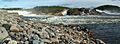
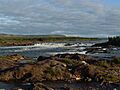
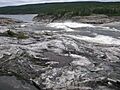
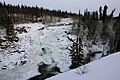
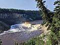
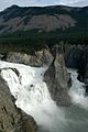
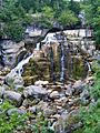
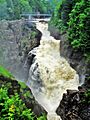
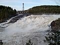
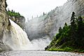
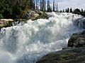
Notable Waterfalls by Province
Canada has many amazing waterfalls spread across its provinces and territories. Here are some of the most well-known ones in different regions.
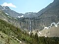
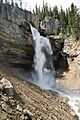
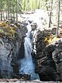
Alberta's Waterfalls
Alberta is home to many beautiful waterfalls, especially in its mountain regions.
| Waterfall | Image | River | Drop (meters) | Width (meters) | Type | Location |
|---|---|---|---|---|---|---|
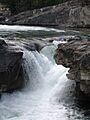
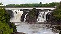
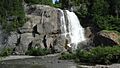
| Athabasca Falls | Athabasca River | 24 | 18 | Segmented Horsetail | 52°39′51″N 117°53′01″W / 52.66417°N 117.88361°W | |
| Bow Falls | Bow River | 9 | 37 | Cascade | 51°9′57″N 115°33′35″W / 51.16583°N 115.55972°W | |
| Bow Glacier Falls | Bow River | 120 | 57 | Horsetail | 51°39′11″N 116°29′57″W / 51.65306°N 116.49917°W | |
| Bridal Veil Falls (Banff) | An unnamed stream | 86 | 5 | Tiered Plunges | 52°11′01″N 117°03′07″W / 52.18361°N 117.05194°W | |
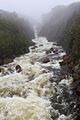
| Crescent Falls | Bighorn River | Tiered | 52°23′14″N 116°21′15″W / 52.38722°N 116.35417°W | |||
| Crypt Falls | Hellroaring Creek | 175 | 15 | Horsetail | 49°0′18″N 113°50′35″W / 49.00500°N 113.84306°W | |
| Elbow Falls | Elbow River | Cascade | 50°51′31″N 114°47′32″W / 50.85861°N 114.79222°W | |||
| Panther Falls | Nigel Creek | 66 | 12 | Plunge | 52°10′54″N 117°3′29″W / 52.18167°N 117.05806°W | |
| Siffleur Falls | Siffleur River | 52°1′14″N 116°21′58″W / 52.02056°N 116.36611°W |


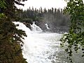
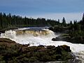
Manitoba's Waterfalls
Manitoba has some beautiful waterfalls, often found in its provincial parks.
| Image | Waterfall | River | Drop (meters) | Width (meters) | Type | Location |
|---|---|---|---|---|---|---|
| Kwasitchewan Falls | Grass River | 14 | 55°15′55″N 98°17′22″W / 55.2653°N 98.2895°W | |||
| Pisew Falls | Grass River | 13 | 47 | 55°11′50″N 98°23′51″W / 55.19722°N 98.39750°W |


New Brunswick's Waterfalls
New Brunswick features waterfalls that are both natural wonders and important for power generation.
| Waterfall | Image | River | Drop (meters) | Width (meters) | Type | Location |
|---|---|---|---|---|---|---|
| Grand Falls | Saint Croix River | 45°16′30″N 67°28′43″W / 45.275°N 67.4785°W | ||||
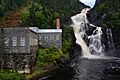
| Nepisiguit (Grand) Falls | Nepisiguit River | 75 | Segmented Block | 47°24′19″N 65°47′29″W / 47.40528°N 65.79139°W |

Newfoundland & Labrador's Waterfalls
This eastern province has rugged landscapes and impressive waterfalls, some of which are very tall.
| Waterfall | Image | River | Drop (meters) | Width (meters) | Type | Location |
|---|---|---|---|---|---|---|
| Churchill Falls | Churchill River | 75 | Segmented Block | 53°36′00″N 64°18′57″W / 53.60000°N 64.31583°W | ||
| Pissing Mare Falls | Burnt Woods Brook | 350 | Plunge, Cascade | |||
| Rattling Brook Falls | Rattling Brook | 140 | Tiered |


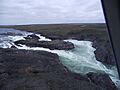
Northwest Territories' Waterfalls
The vast Northwest Territories are home to some of Canada's most powerful and remote waterfalls.
| Waterfall | Image | River | Drop (meters) | Width (meters) | Type | Location |
|---|---|---|---|---|---|---|
| Alexandra Falls | Hay River | 33 | 117 | Vertical Block | 60°30′02″N 116°16′48″W / 60.5005°N 116.2799°W | |
| Cameron Falls | Cameron River | 17 | Steep cascade | 62°31′14″N 113°41′16″W / 62.5206°N 113.6877°W | ||
| Louise Falls | Hay River | 15 | 183 | Vertical Block | 60°30′10″N 116°14′34″W / 60.5029°N 116.2427°W | |
| Virginia Falls | South Nahanni River | 90 | 305 | Segmented Horsetails | 61°36′27″N 125°44′20″W / 61.6074°N 125.7389°W |

.jpg)

Nunavut, in Canada's Arctic, has unique and often remote waterfalls.
| Waterfall | Image | River | Drop (meters) | Width (meters) | Type | Location |
|---|---|---|---|---|---|---|
| Kattimannap Qurlua | Hood River | 49 | Segmented Plunges | 67°05′43″N 108°47′51″W / 67.0952°N 108.7974°W | ||
| Kazan Falls | Kazan River | 25 | 63°42′51″N 95°50′48″W / 63.7142°N 95.8467°W |


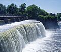
Ontario's Waterfalls
Ontario is famous for one of the world's most iconic waterfalls, Niagara Falls, but it has many others too!
| Image | Waterfall | River | Drop (meters) | Width (meters) | Type | Location |
|---|---|---|---|---|---|---|
| Niagara Falls | Niagara River | 53 | 671 | Segmented Block | 43°04′38″N 79°04′32″W / 43.077305°N 79.07562°W | |
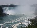
| Horseshoe Falls | Niagara River | 52 | Segmented Block | 43°04′48″N 79°04′16″W / 43.080°N 79.071°W | ||
| Bridal Veil Falls | Kagawong River | 11 | Plunge | 45°54′02″N 82°15′23″W / 45.90048°N 82.25651°W | ||
| Chats Falls | Ottawa River | 16 | 45°28′35″N 76°14′55″W / 45.47639°N 76.24861°W | |||
| Chaudière Falls | Ottawa River | 15 | 60 | 45°25′14″N 75°43′20″W / 45.42056°N 75.72222°W | ||
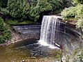
| Fenelon Falls, Ontario | Trent-Severn Waterway | 15 | 7 | Plunge | 44°32′08″N 78°44′13″W / 44.53556°N 78.73694°W | |
| Hog's Back Falls | Rideau River | 18 | Artificially created | 45°22′16″N 75°41′49″W / 45.371021°N 75.697024°W | ||
| Inglis Falls | Sydenham River | 18 | Cascade | 44°31′33″N 80°56′05″W / 44.525701°N 80.93482°W | ||
| Kakabeka Falls | Kaministiquia River | 40 | Plunge | 48°24′10″N 89°37′32″W / 48.4029°N 89.6256°W | ||
| Onaping Falls | Onaping River | Cascade | ||||
| Rideau Falls | Rideau River | 45°26′29″N 75°41′46″W / 45.441405°N 75.69623°W | ||||
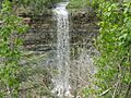
| Albion Falls | Red Hill Creek | 19 | 18 | Classical/Cascade | 43°12′02″N 79°49′11″W / 43.200472°N 79.819676°W | |
| Borer's Falls | Borer's Creek | 15 | High ribbon-style | 43°16′52.33″N 79°55′51.71″W / 43.2812028°N 79.9310306°W | ||
| Webster's Falls | Spencer Creek | 22 | 30 | Curtain/Plunge | 43°16′34″N 79°58′51″W / 43.276241°N 79.980898°W |


Quebec's Waterfalls
Quebec has many beautiful waterfalls, from powerful river drops to scenic cascades.
| Waterfall | Image | River | Drop (meters) | Width (meters) | Type | Location |
|---|---|---|---|---|---|---|
| Brador Falls | Brador River | 51°30′25″N 57°14′52″W / 51.5069°N 57.2479°W | ||||
| Chats Falls | Ottawa River | 11 | 45°28′35″N 76°14′55″W / 45.47639°N 76.24861°W | |||
| Chaudière Falls | Chaudière River | 35 | 240 | 46°42′47″N 71°17′10″W / 46.71306°N 71.28611°W | ||
| Chaudière Falls | Ottawa River | 15 | 60 | 45°25′14″N 75°43′20″W / 45.42056°N 75.72222°W | ||
| Granite Falls | Caniapiscau River | 21 | 55°50′38″N 68°25′22″W / 55.84389°N 68.42278°W | |||
| Kabir Kouba | Saint-Charles River | 28 | 46°51′19″N 71°21′20″W / 46.85528°N 71.35556°W | |||
| Limestone Falls | Caniapiscau River | 22 | 335 | 57°28′53″N 69°18′35″W / 57.48139°N 69.30972°W | ||
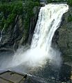
| Montmorency Falls | Montmorency River | 84 | 46°53′27″N 71°8′51″W / 46.89083°N 71.14750°W | |||
| Neigette Falls | Neigette River | 48°26′14″N 68°18′59″W / 48.43722°N 68.31639°W | ||||
| Ouiatchouan Falls | Ouiatchouan River | 79 | 48°25′56″N 72°10′06″W / 48.43222°N 72.16833°W | |||
| Pico Falls | Gilmour Creek | 48°01′36″N 66°57′21″W / 48.0267°N 66.9557°W | ||||
| Saint Anne Falls | Sainte-Anne River | 70 | 47°04′23″N 70°52′39″W / 47.07306°N 70.87750°W | |||
| Shale Falls | Caniapiscau River | 18 | 56°44′39″N 69°01′05″W / 56.74417°N 69.01806°W | |||
| Shawinigan Falls | Saint-Maurice River | 46 | 46°31′51″N 72°45′40″W / 46.53086°N 72.76102°W | |||
| Vauréal Falls | Vauréal River | 49°33′37″N 62°41′35″W / 49.56028°N 62.69306°W |

.jpg)


Saskatchewan's Waterfalls
Saskatchewan, known for its prairies, also has some beautiful waterfalls, especially in its northern regions.
| Waterfall | Image | River | Height (meters) | Width (meters) | Type | Location |
|---|---|---|---|---|---|---|
| Elizabeth Falls | Fond du Lac River | 34 | 59°10′48″N 105°33′24″W / 59.1801°N 105.5566°W | |||
| Hunt Falls | Grease River | 15 | 60 | 59°28′40″N 106°25′35″W / 59.4778°N 106.4263°W | ||
| Nistowiak Falls | Rapid River | 10 | Segmented | 55°23′46″N 104°21′59″W / 55.39611°N 104.36639°W |

Yukon's Waterfalls
The Yukon Territory, in Canada's far north, has rugged and wild waterfalls.
| Waterfall | Image | River | Height (meters) | Width (meters) | Type | Location |
|---|---|---|---|---|---|---|
| Otter Falls | Aishihik River | 61°04′54″N 136°59′42″W / 61.0818°N 136.9950°W | ||||
| Rancheria Falls | Rancheria River | 8 | Cascade | 60°04′40″N 130°49′43″W / 60.0778°N 130.8287°W |

Images for kids
-
Limestone Falls
-
Pyrite Falls
-
Shale Falls
-
Granite Falls
-
Little Eaton Canyon Falls
-
Lower Eaton Canyon Falls
-
Nastapoca Falls
-
Upper Eaton Canyon Falls
-
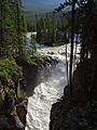
Lower Sunwapta Falls
-
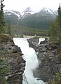
Athabasca Falls
-
Bow Falls
-
Bow Glacier Falls
-
Bridal Veil Falls
-
Crescent Falls
-
Crypt Falls
-
Elbow Falls
-
Panther Falls
-
Siffleur Falls
-
Kwasitchewan Falls
-
Pisew Falls
-
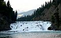
Grand Falls
-
Churchill Falls
-
Rattling Brook Falls
-
Alexandra Falls
-
Cameron Falls
-
Louise Falls
-
Virginia Falls
-

Kattimannap Qurlua
-
Kazan Falls
-
Horseshoe Falls
-
Horseshoe Falls
-
Bridal Veil Falls
-
Chats Falls
-
Chaudière Falls
-
Fenelon Falls
-
Hog's Back Falls
-
Inglis Falls
-
Kakabeka Falls
-
Onaping Falls
-
Rideau Falls
-
Albion Falls
-
Borer's Falls
-
Brador Falls
-
Chaudière Falls
-
Kabir Kouba
-
Montmorency Falls
-
Neigette Falls
-
Ouiatchouan Falls
-
Pico Falls
-
Saint Anne Falls
-
Shawinigan Falls
-
Vauréal Falls
-
Nistowiak Falls
-
Otter Falls

See also
