Mahoning County, Ohio facts for kids
Quick facts for kids
Mahoning County
|
|||
|---|---|---|---|

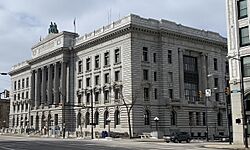
Mahoning County Courthouse
|
|||
|
|||

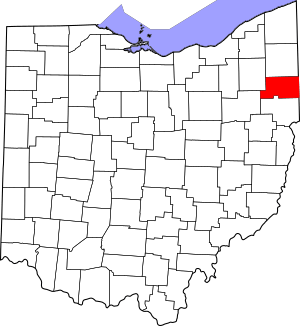
Location within the U.S. state of Ohio
|
|||
 Ohio's location within the U.S. |
|||
| Country | |||
| State | |||
| Founded | March 1, 1846 | ||
| Named for | A Native American word for salt lick | ||
| Seat | Youngstown | ||
| Largest city | Youngstown | ||
| Area | |||
| • Total | 425 sq mi (1,100 km2) | ||
| • Land | 412 sq mi (1,070 km2) | ||
| • Water | 14 sq mi (40 km2) 3.2%% | ||
| Population
(2020)
|
|||
| • Total | 228,614 | ||
| • Estimate
(2021)
|
226,762 |
||
| • Density | 537.9/sq mi (207.69/km2) | ||
| Time zone | UTC−5 (Eastern) | ||
| • Summer (DST) | UTC−4 (EDT) | ||
| Congressional district | 6th | ||
Mahoning County is a county in the state of Ohio, USA. It is located in the northeastern part of Ohio. In 2020, about 228,614 people lived there.
The biggest city and the main center of the county is Youngstown. The county is named after the Mahoning River. It was created on March 1, 1846. This made it the 83rd county in Ohio. Before 1846, this area was part of Trumbull and Columbiana counties. Mahoning County is now part of the larger Youngstown–Warren, OH Metropolitan Statistical Area.
History
In the 1600s, the land that is now Mahoning County was home to different Native American groups. The Erie people likely lived in the east. The Whittlesey culture was probably in the west. We don't know the exact borders between them.
The Erie were an Iroquoian group. They may have arrived between 1100 and 1300 AD. They followed an older group called "Mound Builders." The Whittlesey people were likely Algonquian. They lived in longhouses, which were different from typical Algonquian homes.
After a series of conflicts called the Beaver Wars, new tribes moved into the Mahoning Valley. These tribes included the Seneca, Lenape (also known as Delaware), Shawnee, and Wyandot. The Seneca and Wyandot were Iroquoian. The Lenape and Shawnee were Algonquian.
Later, as settlers moved into northeast Ohio, Native American tribes were pushed out. This area became part of the Connecticut Western Reserve. By the early to mid-1800s, the United States moved all tribes out of Ohio.
Some important Native American sites were once in Mahoning County. One was Council Rock in Youngstown. The Shawnee and Lenape gathered there for celebrations and meetings. The rock was moved but is now in Lincoln Park. Another site was the North Benton burial mound. It was found near North Benton. Archeologists removed it. This mound was linked to the Hopewell culture. It had unique features, like sculptures of constellations made from white rocks.
In the early 1800s, a family of Huguenot refugees settled in what would become Mahoning County.
In the 1900s, Youngstown became a major center for the American steel industry. It was also home to Warner Theatre. This is where the Warner Bros. film studio began. It was an important place for early movies and TV for many years. There was once a large German community in Berlin Township. After the World Wars, they faced pressure to fit in, and the community changed. A local favorite food, Brier Hill Pizza, was created in Youngstown's Brier Hill neighborhood.
Geography
The United States Census Bureau says Mahoning County covers about 425 square miles. Most of this, about 412 square miles, is land. The remaining 14 square miles, or 3.2%, is water.
Adjacent counties
- Trumbull County (north)
- Mercer County, Pennsylvania (northeast)
- Lawrence County, Pennsylvania (east)
- Columbiana County (south)
- Stark County (southwest)
- Portage County (northwest)
Major highways
 I-76
I-76
 I-76 / Ohio Turnpike
 I-80 / Ohio Turnpike
 I-80
I-80 I-680
I-680 US 62
US 62 US 224
 US 422
 SR 7
SR 7 SR 11
SR 11 SR 14
SR 14 SR 45
SR 45 SR 46
SR 46 SR 164
 SR 165
 SR 170
 SR 193
 SR 289
 SR 446
 SR 534
 SR 616
 SR 617
 SR 625
 SR 626
 SR 630
Demographics
| Historical population | |||
|---|---|---|---|
| Census | Pop. | %± | |
| 1850 | 23,735 | — | |
| 1860 | 25,894 | 9.1% | |
| 1870 | 31,001 | 19.7% | |
| 1880 | 42,871 | 38.3% | |
| 1890 | 55,979 | 30.6% | |
| 1900 | 70,134 | 25.3% | |
| 1910 | 116,151 | 65.6% | |
| 1920 | 186,310 | 60.4% | |
| 1930 | 236,142 | 26.7% | |
| 1940 | 240,251 | 1.7% | |
| 1950 | 257,629 | 7.2% | |
| 1960 | 300,480 | 16.6% | |
| 1970 | 303,424 | 1.0% | |
| 1980 | 289,487 | −4.6% | |
| 1990 | 264,806 | −8.5% | |
| 2000 | 257,555 | −2.7% | |
| 2010 | 238,823 | −7.3% | |
| 2020 | 228,614 | −4.3% | |
| 2021 (est.) | 226,762 | −5.1% | |
| U.S. Decennial Census 1790-1960 1900-1990 1990-2000 2010-2020 |
|||
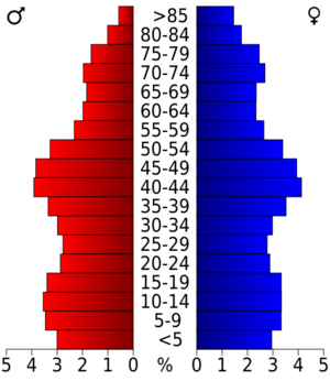
In 2010, there were 238,823 people living in Mahoning County. There were about 98,712 households. The population density was about 580 people per square mile.
Most people in the county were white (79.9%). About 15.7% were black or African American. Other groups included Asian (0.7%) and American Indian (0.2%). About 4.7% of the population was Hispanic or Latino.
Many people had German (21.4%), Italian (18.4%), or Irish (16.6%) backgrounds. About 27.9% of households had children under 18. The average household had 2.34 people. The average age in the county was 42.9 years old.
The average income for a household was $40,123. For families, it was $52,489.
Economy
Top Employers
Here are the biggest employers in Mahoning County, based on a 2019 report:
| # | Employer | # of Employees |
|---|---|---|
| 1 | Mercy Health | 3,000 |
| 2 | Youngstown City School District | 1,791 |
| 3 | Mahoning County | 1,600 |
| 4 | Youngstown State University | 1,200 |
| 5 | VXI Global Solutions | 1,100 |
| 6 | City of Youngstown | 1,063 |
| 7 | Infocision Management | 1,050 |
| 8 | Windsor House Assisted Living | 850 |
| 9 | Austintown Local School District | 800 |
| 10 | Akron Children's Hospital | 800 |
Education
Colleges and universities
- Avalon University School of Medicine
- Youngstown State University
Community, junior, and technical colleges
- Choffin Career and Technical Center
- Eastern Gateway Community College
- Mahoning County Career and Technical Center
Public school districts
School districts in Mahoning County include:
- Alliance City School District
- Austintown Local School District
- Boardman Local School District
- Campbell City School District
- Canfield Local School District
- Columbiana Exempted Village School District
- Girard City School District
- Hubbard Exempted Village School District
- Jackson-Milton Local School District
- Leetonia Exempted Village School District
- Lowellville Local School District
- Poland Local School District
- Sebring Local School District
- South Range Local School District
- Springfield Local School District
- Struthers City School District
- Weathersfield Local School District
- West Branch Local School District
- Western Reserve Local School District
- Youngstown City School District
High schools
- Austintown Fitch High School
- Boardman High School
- Campbell Memorial High School
- Canfield High School
- Cardinal Mooney High School
- Chaney High School
- East High School
- Jackson-Milton High School
- Lowellville High School
- Mahoning County High School
- McKinley High School
- Poland Seminary High School
- South Range High School
- Springfield High School
- Struthers High School
- Ursuline High School
- Valley Christian School
- Valley STEM + ME2 Academy
- West Branch High School
- Western Reserve High School
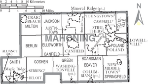
Communities
Cities
Villages
Townships
- Austintown
- Beaver
- Berlin
- Boardman
- Canfield
- Coitsville
- Ellsworth
- Goshen
- Green
- Jackson
- Milton
- Poland
- Smith
- Springfield
Census-designated places
Unincorporated communities
Population ranking
This table shows the population of cities, towns, and other places in Mahoning County, based on the 2020 census.
* A small part of this place is in Mahoning County.
† This is the county seat (main city).
| Rank | City/Town/etc. | Population (2010 Census) | Municipal type |
|---|---|---|---|
| 1 | † Youngstown | 60,068 | City |
| 2 | Austintown | 29,594 | CDP |
| 3 | Alliance* | 21,672 | City |
| 4 | Salem* | 11,915 | City |
| 5 | Struthers | 10,063 | City |
| 6 | Campbell | 7,852 | City |
| 7 | Canfield | 7,699 | City |
| 8 | Columbiana* | 6,559 | City |
| 9 | Sebring | 4,191 | Village |
| 10 | Mineral Ridge* | 3,951 | CDP |
| 11 | Poland | 2,463 | Village |
| 12 | Woodworth | 1,784 | CDP |
| 13 | New Middletown | 1,507 | Village |
| 14 | North Lima | 1,369 | CDP |
| 15 | Craig Beach | 1,076 | Village |
| 16 | Lowellville | 996 | Village |
| 17 | Beloit | 903 | Village |
| 18 | Washingtonville* | 712 | Village |
| 19 | Maple Ridge | 667 | CDP |
| 20 | Lake Milton | 637 | CDP |
| 21 | New Springfield | 579 | CDP |
| 22 | Damascus | 418 | CDP |
| 23 | Petersburg | 405 | CDP |
| 24 | East Alliance | 268 | CDP |
See also
 In Spanish: Condado de Mahoning para niños
 | Stephanie Wilson |
 | Charles Bolden |
 | Ronald McNair |
 | Frederick D. Gregory |


