
National Register of Historic Places listings in Oglethorpe County, Georgia facts for kids

Welcome to Oglethorpe County, Georgia! Did you know that many old and important buildings, bridges, and even whole neighborhoods here are considered so special that they are listed on something called the National Register of Historic Places (NRHP)? This is like a special list kept by the United States government to help protect places that are important to history. When a place is on this list, it means it has a unique story to tell about the past, and people want to make sure it stays around for a long time.
In Oglethorpe County, you can find several amazing spots on this list. They include old homes, a train station, and even historic areas where many buildings together tell a story. Let's explore some of these cool places!
Contents
Historic Places in Oglethorpe County
This section lists some of the interesting places in Oglethorpe County that are recognized for their historical importance. Each one has a unique past!
Homes with History
Many of the places on the National Register are old homes that show us how people lived a long time ago.
- Amis-Elder House: This old house is located west of Crawford on Elder Road. It was added to the list in 1978.
- J. L. Bridges Home Place: You can find this historic home north of Lexington on Georgia Highway 22. It became a registered historic place in 1978.
- Faust Houses and Outbuildings: This group of buildings is northeast of Lexington, off Georgia Highway 77. It joined the list in 1980.
- Langston-Daniel House: About 5 miles (8 km) west of Crawford on U.S. Highway 78, this house was recognized in 1978.
- Smith-Harris House: Located on County Road 207 near Vesta, this house was added to the list in 1985.
Special Buildings and Bridges
Besides homes, other types of structures are also important to history.
- Crawford Depot: This old train station in Crawford, located on U.S. Highway 78, was listed in 1977. Train depots were very important for travel and trade in the past!
- Howard's Covered Bridge: About 3 miles (4.8 km) southeast of Smithonia, this historic covered bridge crosses Big Clouds Creek. It was added to the list in 1975. Covered bridges are quite rare and beautiful!
- Watson Mill Covered Bridge and Mill Historic District: This area includes another famous covered bridge and an old mill along the South Fork Broad River, inside Watson Mill State Park near Comer. It became a historic district in 1991.
Historic Districts
Sometimes, it's not just one building but a whole area that is historically important. These are called historic districts.
- Lexington Historic District: This district is in Lexington, along U.S. Highway 78. It was recognized in 1977. It includes many buildings that together tell the story of the town.
- Philomath Historic District: Located in Philomath on Georgia Highway 22, this district was added to the list in 1979.
- Smithonia: This historic area near Comer was listed in 1984. The exact address is restricted, but it's a significant historical site.
Images for kids
-
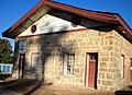
The historic Crawford Depot.
-
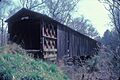
Howard's Covered Bridge, a beautiful old structure.
-
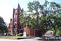
The Oglethorpe County Courthouse, part of the Lexington Historic District.
-
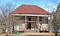
The Bryan-Wolfe House, located in the Philomath Historic District.
-

A view of Smithonia, a historic district.
-
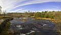
Watson Mill Covered Bridge, a key part of its historic district.


