
National Register of Historic Places listings in Newton County, Georgia facts for kids
Newton County, Georgia, is full of amazing places that tell stories from the past! Many of these special spots are listed on the National Register of Historic Places. This is like a national "hall of fame" for buildings, areas, and sites that are important to American history. When a place is on this list, it means it's worth protecting and remembering for future generations. Let's explore some of these cool historic places right here in Newton County!
Discovering History in Newton County
Newton County has many buildings and areas that are super important to history. These places are officially recognized by the National Park Service as part of the National Register of Historic Places (NRHP). Being on this list helps protect these sites and reminds us of the past.
What is the National Register of Historic Places?
The National Register of Historic Places is the official list of the nation's historic places. It includes buildings, structures, objects, sites, and districts. These places are important because they tell us about history, architecture, archaeology, engineering, or culture. It's like a special club for old and important places!
Special Places in Covington
Covington, a main city in Newton County, has many historic treasures.
The Old Brick Store
One interesting spot is the Brick Store. It's located on U.S. Route 278 near Old Social Circle Road. This building was added to the National Register in 2009. Imagine all the things that have been bought and sold there over the years!

Newton County Courthouse
The Newton County Courthouse is another important building. It stands proudly on Courthouse Square in Covington. This courthouse was built a long time ago and was added to the National Register in 1980. It's where many important decisions for the county have been made.

Historic Neighborhoods in Covington
Covington also has several historic districts. A historic district is an area with many buildings that are all old and important together.
- The Covington Historic District covers a large part of the city south of US 278.
- The Covington Mills and Mill Village Historic District shows us where people used to work and live near the old mills.
- The Floyd Street Historic District focuses on a specific street with historic homes.
- The North Covington Historic District includes areas around N. Emory and Odum Streets.
- The Salem Camp Ground is a unique historic district that was added to the list in 1998. It's a place where people used to gather for religious meetings.
Historic Spots in Oxford
Just a short distance from Covington is the town of Oxford, which also has its own historic gems.
Orna Villa
Orna Villa is a historic house located at 1008 N. Emory Street in Oxford. This beautiful home was recognized as a historic place in 1973. It's a great example of old architecture.

Oxford's Historic Campus
The Oxford Historic District is centered around Wesley Street. This area includes parts of the Emory University campus, which started in Oxford. It was added to the National Register in 1975. It's cool to think about all the students who have walked through these historic grounds!

Other Historic Areas in Newton County
Newton County has other historic districts that are important to its story:
- The Burge Farm near Newborn is a large historic area.
- The Newborn Historic District covers almost the entire city of Newborn.
- The Porterdale Historic District includes much of the city of Porterdale.
- The Starrsville Historic District is located at the junction of GA 213, Old Starrsville, and Dixie Roads.
All these places help us understand the rich history of Newton County, Georgia!
Images for kids
-
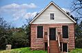
The historic Brick Store in Covington.
-
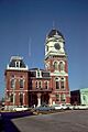
The Newton County Courthouse.
-
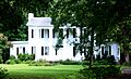
Orna Villa in Oxford.
-

Seney Hall, part of the Oxford Historic District.
