
National Register of Historic Places listings in Barrow County, Georgia facts for kids
This page lists special places and areas in Barrow County, Georgia that are recognized for their history. These places are officially listed on the National Register of Historic Places (NRHP). The NRHP is like a special club for buildings, sites, and districts that are important to American history, architecture, archaeology, engineering, or culture. When a place is on the NRHP, it means it's worth protecting and learning about!
Contents
Historic Places in Barrow County
Many of the places on this list are in Winder, the main city in Barrow County. Others are in nearby towns like Auburn, Bethlehem, Russell, and Statham. These listings include individual buildings and larger areas called "historic districts." A historic district is a group of buildings, usually in a neighborhood or downtown area, that share a common history or architectural style.
Winder's Historic Districts
Winder has several historic districts that show how the town grew and changed over time.
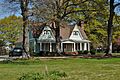
Athens-Candler-Church Street Historic District
This district includes parts of Candler Street, Church Street, and Athens Street. It's a residential area, meaning it's mostly homes. These homes give us a peek into what Winder looked like in the past.

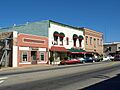
Broad Street Commercial Historic District
This district covers parts of Broad and Athens Streets. It's a "commercial" district, which means it was once (and still is) a busy area for shops and businesses. Imagine people doing their shopping here many years ago!

Jackson Street Commercial Historic District
Close to the Broad Street district, this area is bounded by Jackson, Athens, Candler, and Broad Streets. It also served as a commercial hub, showing how important these streets were for Winder's economy.

North Broad Street Residential Historic District
This district is another residential area in Winder, roughly bordered by Woodlawn Avenue, Center, Broad, and Stephens Streets. It features more historic homes, adding to the town's charming character.

Auburn Historic District
The Auburn Historic District is in the town of Auburn. It's generally located around 3rd Avenue, 6th Street, 6th Avenue, and Main Street. This district helps preserve the unique history and look of Auburn's older areas.

Russell Homeplace Historic District
This district is located on US 29 in Russell. It's a historic area that tells the story of the Russell community.
Statham Historic District
In Statham, this district is roughly bounded by Elizabeth, 8th, and 1st Streets, and the CSX railroad tracks. It includes buildings that show the history of Statham, especially how the railroad influenced its development.

Important Individual Buildings and Sites
Besides historic districts, several individual buildings and sites in Barrow County are also listed on the National Register of Historic Places.
Barrow County Courthouse
The Barrow County Courthouse is located on Courthouse Square in Winder. This impressive building is where many important decisions for the county have been made over the years. Courthouses are often central to a town's history and community life.

Carlyle-Blakey Farm
The Carlyle-Blakey Farm is located at 568 GA 211 NW in Winder. This farm is recognized for its historical importance, likely related to agriculture and the way people lived and worked in the past.
Jackson-Johns House
The Jackson-Johns House was located at 116 Candler Street in Winder. Sadly, this historic house was demolished as of October 2012, but it was once an important part of Winder's history.
Kilgore Mill Covered Bridge and Mill Site
The Kilgore Mill Covered Bridge and Mill Site is about 3.5 miles southwest of Bethlehem, crossing the Apalachee River. Covered bridges are very special because they are rare and show old building techniques. This site also includes the remains of a mill, which was important for grinding grain in the past.

Manning Gin Farm
The Manning Gin Farm is located at the junction of Manning Gin and McElhannon Roads in Bethlehem. A "gin" refers to a cotton gin, a machine used to separate cotton fibers from their seeds. This farm likely played a role in the region's agricultural history, especially cotton farming.
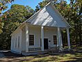
Omer Christian Church and Cemetery
The Omer Christian Church and Cemetery is found at the junction of GA 316 and GA 324 in Winder. Churches and their cemeteries are often very old and hold many stories about the people who lived in the area.

Rockwell Universalist Church
The Rockwell Universalist Church is located at GA 53 and Rockwell Church Road in Winder. This church is another example of a historic religious building in Barrow County, showing the different faiths and communities that have shaped the area.

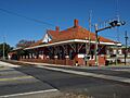
Winder Depot
The Winder Depot is located at Broad and Porter Streets in Winder. A "depot" is a train station. This building was once a busy place where people traveled and goods were shipped by train, showing the importance of railroads in connecting towns and helping them grow.

Images for kids
-
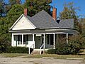
A historic home on Church Street in Winder.
-
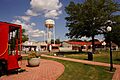
A building in the Auburn Historic District.
-
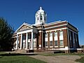
The Barrow County Courthouse in Winder.
-
Historic buildings on North Broad Street in Winder.
-
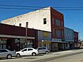
A view of East Athens Street in Winder.
-
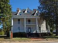
A historic house on West Candler Street in Winder.
-
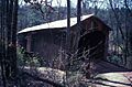
The historic Kilgore Mill Covered Bridge.
-
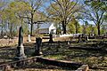
The Omer Christian Church and Cemetery.
-
The Rockwell Universalist Church.
-
Broad Street in Statham, as it looked around 1922.
-
The Winder Depot, an old train station.
