
National Register of Historic Places listings in Coweta County, Georgia facts for kids
This article is about special places in Coweta County, Georgia that are listed on the National Register of Historic Places. This list helps protect buildings, homes, and areas that are important to history.
Contents
Discovering History in Coweta County
Coweta County in Georgia is home to many places that have a rich history. These places are like windows into the past, showing us how people lived, worked, and built communities long ago. To make sure these important spots are saved for future generations, they are often added to a special list.
What is the National Register of Historic Places?
The National Register of Historic Places (NRHP) is like a VIP list for historic buildings, sites, and districts across the United States. When a place is added to this list, it means it's recognized as important to the history of a state or the entire country. Being on the NRHP encourages people to protect these places. It also helps preserve their unique stories and architecture.
Historic Places in Coweta County
Coweta County has many different types of places on the National Register. These include old courthouses, beautiful homes, and even entire neighborhoods or towns. Each one tells a part of Coweta County's story.
Cool Buildings and Homes
- Coweta County Courthouse: Located in Newnan, this courthouse is a grand building where important decisions have been made for many years. It was added to the list in 1980.
- Hollberg Hotel: In Senoia, the Hollberg Hotel was once a busy place for travelers. It joined the NRHP in 1980, showing its importance as a historic stopping point.
- Powell Chapel School: This old school building in Newnan was listed in 2003. It reminds us of how education used to happen in the community.
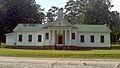
- Mary Ray Memorial School: Found in Raymond, this school building was recognized in 2013. It stands as a reminder of local education history.
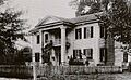
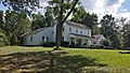
- Vinewood: This historic property in Newnan was added to the list in 2011. It's a beautiful example of an old estate.
Important Districts
- Cole Town District: This historic area in Newnan was listed in 1982. It includes many old homes and streets that show how the town grew.
- Grantville Historic District: The heart of Grantville is a historic district, recognized in 1991. It includes old buildings and streets that tell the story of the town.
- Newnan Commercial Historic District: The downtown area of Newnan is a historic district. It was listed in 1990 and shows how businesses and shops looked in the past.
- Senoia Historic District: Much of downtown Senoia is a historic district, added in 1989. It has many old buildings that give the town its unique charm.
Images for kids
-
The W. A. Brannon Store-Moreland Knitting Mills in Moreland.
-
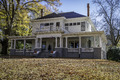
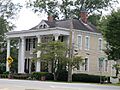
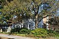
A house in the Cole Town District in Newnan.
-
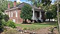
The William Leonard Crowder Home Place in Newnan.
-
The Goodwyn-Bailey House in Newnan.
-
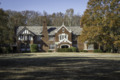
The Gordon-Banks House south of Newnan.
-
Downtown Grantville, part of its historic district.
-
A house in the Greenville Street-LaGrange Street Historic District in Newnan.
-
The Henderson-Orr House near Stallings Crossing.
-
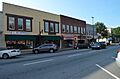
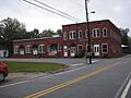
Shops in the Newnan Commercial Historic District.
-
The Newnan Cotton Mill and Mill Village Historic District.
-
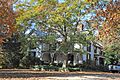
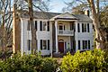
A home in the Northwest Newnan Residential Historic District.
-
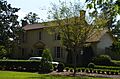
Oak Grove Plantation north of Newnan.
-
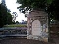
Oak Hill Cemetery in Newnan.
-
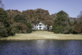
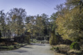
A view from the Platinum Point Historic District in Newnan.
-
The front of Powell Chapel School in Newnan.
-
The Mary Ray Memorial School in Raymond.
-
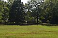
A view from the Roscoe-Dunaway Gardens Historic District.
-
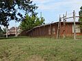
The Arnall Mill Complex in the Sargent Historic District.
-

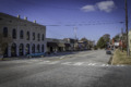
A street view in the Senoia Historic District.
-
The George R. Sims House in Palmetto.
-
The Dr. Robert L. and Sarah Alberta Smith House in Sharpsburg.
-
The Tidwell-Amis-Haynes House in Senoia.
-
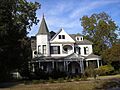
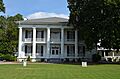
Vinewood in Newnan.
-
The Willcoxon-Arnold House in Newnan.


