
National Register of Historic Places listings in Jackson County, Georgia facts for kids
Did you know that some buildings and places are so special they get listed on a national list to protect them? In Jackson County, Georgia, there are many cool spots that are part of the National Register of Historic Places (NRHP). This list helps make sure these important places are saved for future generations to enjoy and learn from. Think of it like a hall of fame for old buildings and areas!
Contents
- Exploring Jackson County's Historic Places
- Braselton Historic District: A Town's Story
- Commerce Commercial Historic District: Busy Streets of the Past
- Governor L. G. Hardman House: Home of a Leader
- Hillcrest-Allen Clinic and Hospital: A Place of Healing
- Holder Plantation: A Historic Farm
- Hoschton Depot: A Train Station's Legacy
- Jackson County Courthouse: Center of Justice
- Jefferson Historic District: Downtown Charm
- Maysville Historic District: Small Town History
- Oak Avenue Historic District: A Quiet Neighborhood
- Paradise Cemetery: Stories in Stone
- Seaborn M. Shankle House: A Family Home
- Shields-Etheridge Farm: Rural Heritage
- Talmo Historic District: A Village's Past
- Williamson-Maley-Turner Farm: Another Historic Farm
- Images for kids
Exploring Jackson County's Historic Places
Jackson County in Georgia is full of history, and many of its old buildings and areas are recognized as important landmarks. These places tell us stories about how people lived, worked, and built communities long ago. Let's take a look at some of these amazing historic spots!
Braselton Historic District: A Town's Story
The Braselton Historic District is a special area in Braselton, Georgia. It was added to the National Register of Historic Places on April 27, 2001. This district shows us what a town looked like as it grew, especially around the main roads like GA 124 and GA 53. It includes many old buildings that tell the story of Braselton's past.

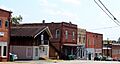
Commerce Commercial Historic District: Busy Streets of the Past
In Commerce, Georgia, the Commerce Commercial Historic District became a historic place on January 19, 1989. This district covers the old business heart of the city. Imagine what it was like when these streets were bustling with shops and people! It includes areas roughly bounded by Line, State, Cherry, Sycamore, and Broad Streets.
Governor L. G. Hardman House: Home of a Leader
Also in Commerce, Georgia, you can find the Governor L. G. Hardman House at 208 Elm Street. This house was listed on June 16, 1988. It was once the home of Governor L. G. Hardman, an important leader in Georgia's history. Learning about his home helps us understand more about his life and times.
Hillcrest-Allen Clinic and Hospital: A Place of Healing
The Hillcrest-Allen Clinic and Hospital in Hoschton, Georgia, was added to the list on May 2, 1985. Located at GA 53 & Peachtree Road, this building was once a place where people went for medical care. It shows us how healthcare was provided in the past.

Holder Plantation: A Historic Farm
Near Jefferson, Georgia, the Holder Plantation joined the National Register on September 5, 1990. This historic farm is located at the junction of Possum Creek Road and US 129. Plantations like this were important parts of Georgia's history, showing how farming and life were organized long ago.
Hoschton Depot: A Train Station's Legacy
The Hoschton Depot at 4276 GA 53 in Hoschton, Georgia, became a historic site on March 31, 2000. Train depots were once very busy places, connecting towns and helping people and goods travel. This depot is a reminder of the important role railroads played in developing communities.

Jackson County Courthouse: Center of Justice
The Jackson County Courthouse in Jefferson, Georgia, located on GA 1, was listed on September 18, 1980. Courthouses are often the heart of a county's government and community life. This building has seen many important decisions and events over the years.

Jefferson Historic District: Downtown Charm
The Jefferson Historic District in Jefferson, Georgia, was recognized on March 26, 2003. This large district includes the downtown business area and extends to parts of the city limits. It's a great place to see many different types of historic buildings that make up the town's character.

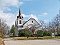
Maysville Historic District: Small Town History
The Maysville Historic District in Maysville, Georgia, was added to the list on September 12, 1985. This district runs along E. Main, W. Main, and Homer Streets. It captures the feel of a small historic town, with buildings that show its unique past.

Oak Avenue Historic District: A Quiet Neighborhood
Another historic area in Jefferson, Georgia, is the Oak Avenue Historic District. It was listed on May 30, 2002, and is located south of the junction of Oak Avenue and the Southern Railroad. This district likely features historic homes and buildings that show how residential areas developed.
Paradise Cemetery: Stories in Stone
The Paradise Cemetery in Jefferson, Georgia, became a historic site on May 30, 2002. It is located east of the Southern Railroad, between Lawrenceville Street and Mahaffey Circle. Cemeteries can be very important historic places, as they hold the stories of people who lived long ago and offer insights into community history and art.
Seaborn M. Shankle House: A Family Home
The Seaborn M. Shankle House at 125 Cherry Street in Commerce, Georgia, was listed on November 29, 1979. This house is an example of a historic family home, giving us a glimpse into the lives of people who lived there in the past.
Shields-Etheridge Farm: Rural Heritage
The Shields-Etheridge Farm was added to the National Register on June 25, 1992. It's located about 5 miles southwest of Jefferson, at the junction of GA 319 and County Road 125. This farm represents the agricultural history of the region and how farming shaped the landscape and communities.
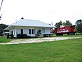
Talmo Historic District: A Village's Past
The Talmo Historic District in Talmo, Georgia, was recognized on September 15, 1997. It is roughly along Main Street, Kinney Avenue, and A.J. Irvin Road. This district helps preserve the historic character of the village of Talmo.

Williamson-Maley-Turner Farm: Another Historic Farm
Finally, the Williamson-Maley-Turner Farm was listed on July 7, 1995. It is located northeast of Jefferson on GA 15. Like the Holder Plantation and Shields-Etheridge Farm, this farm helps us understand the agricultural heritage and rural life of Jackson County.
These historic places are important parts of Jackson County's story. They help us connect with the past and understand how our communities came to be.
Images for kids
-
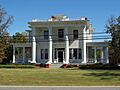
The W.H. Braselton House, now Braselton Town Hall, is part of the historic district.
-
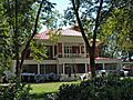
The Hillcrest-Allen Clinic and Hospital building in Hoschton.
-
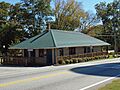
The historic Hoschton Depot.
-
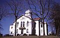
The Jackson County Courthouse in Jefferson.
-
Washington Street in the Jefferson Historic District.
-
The abandoned Maysville United Methodist Church, part of the historic district.
-
The Talmo Rail Depot, part of the Talmo Historic District.
