
National Register of Historic Places listings in Washington County, Georgia facts for kids

Have you ever wondered about the oldest and most special buildings or places in your town? In Washington County, Georgia, there are many such spots! These places are so important that they are listed on something called the National Register of Historic Places (NRHP).
The National Register of Historic Places is like a special list kept by the United States government. It helps to find and protect buildings, sites, and objects that are important to American history, architecture, archaeology, engineering, or culture. When a place is on this list, it means it's recognized as a valuable part of our past.
Washington County has many places on this list, from old homes and schools to banks and churches. These sites help us learn about how people lived, worked, and built communities long ago. Let's explore some of these cool historic spots!
Contents
Historic Places in Washington County
Washington County is home to many buildings and areas that have a special place in history. These sites tell stories about the people and events that shaped the county.
Sandersville's Special Spots
Sandersville, Georgia has many historic places. It's the county seat, which means it's the main town where the government offices are.
Old City Cemetery
The City Cemetery in Sandersville is a very old burial ground. It's located near West Church Street. This cemetery was added to the National Register in 1987. It's a quiet place that holds the history of many people who lived in Sandersville over the years.
Thomas Jefferson Elder High School
The Thomas Jefferson Elder High and Industrial School is an important building on Hall Street. It was listed in 1981. This school was very important for education in the community, especially for African American students during a time when schools were separated. It helped many young people learn and grow.
Historic Districts in Sandersville
Sandersville also has several "historic districts." These are areas where many buildings together tell a story.
- The Church-Smith-Harris Street Historic District includes several streets with old buildings. It was recognized in 1987.
- The North Harris Street Historic District is another area with historic homes and buildings. It was added to the list in 1989.
- The Sandersville Commercial and Industrial District covers parts of the downtown area. This district shows how businesses and industries grew in Sandersville. It was listed in 2002. You can see old shops and offices here.
Washington County Courthouse
The Washington County Courthouse is a grand building in Courthouse Square. It was built a long time ago and is where important county decisions are made. It became a historic place in 1980. Courthouses are often central to a town's history.
Other Notable Sandersville Buildings
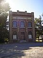
- The Holt Brothers Banking Company Building on Malone Street is an old bank building. It was listed in 1994. It shows what banks looked like in the past.
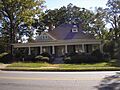
- The James E. Johnson House on West Church Street is a historic home. It was also added to the National Register in 1994.
Tennille's Treasures
The town of Tennille, Georgia also has many historic buildings.
Tennille's Banking and Church Buildings
- The Tennille Banking Company Building on North Main Street is another example of an old bank. It was listed in 1994.
- The Tennille Baptist Church on North Main Street is a beautiful old church. It was also recognized in 1994. Churches often have deep roots in a community's history.
Historic Homes in Tennille
- The James Kelley House is located east of the junction with GA 15. This old home was added to the list in 1994.
- The Charles Madden House on East South Central Street is another historic home in Tennille, listed in 1994.
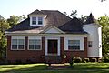
- The Thomas W. Smith House on North Main Street is also a historic residence, recognized in 1994.
Tennille Woman's Clubhouse
The Tennille Woman's Clubhouse on Smith Street is a special place. It was listed in 1998. Clubhouses like this were important gathering spots for women's groups, who often worked to improve their communities.
Washington Manufacturing Company
The Washington Manufacturing Company building in Tennille, located between East Montgomery and Church Streets, was listed in 1994. This building tells us about the industrial past of the area.
Wrightsville and Tennille Railroad Company Building
The Wrightsville and Tennille Railroad Company Building on Central Avenue was added to the list in 1994. Railroads were super important for transportation and trade in the past, so this building is a reminder of that history.
Historic Spots Beyond the Towns
Washington County's historic places aren't just in Sandersville and Tennille.
Francis Plantation
The Francis Plantation is located southeast of Davisboro, Georgia on SR 2189. This historic site was listed in 1975. Plantations are large farms that played a big role in Georgia's history.
Forest Grove
Forest Grove near Sandersville on GA 242/Riddleville Road was added to the list in 2005. It's another important historic property in the county.
Warthen Historic District
The Warthen Historic District is in the town of Warthen, Georgia. It's located at the junction of several roads. This district was listed in 1997 and includes many buildings that show the history of this small community.
These historic places in Washington County help us understand the past and appreciate the unique stories of Georgia.
Images for kids
-
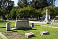
The City Cemetery in Sandersville, a historic burial ground.
-
The Holt Brothers Banking Company Building in Sandersville.
-
The historic James E. Johnson House in Sandersville.
-
The Thomas W. Smith House in Tennille.
-
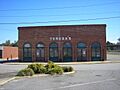
The Tennille Banking Company Building.
-
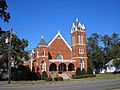
The Tennille Baptist Church.
-
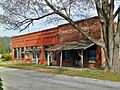
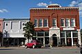
Abandoned storefronts in the Warthen Historic District.
-
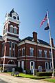
The Washington County Courthouse in Sandersville.
-
The Wrightsville and Tennille Railroad Company Building.


