
National Register of Historic Places listings in McIntosh County, Georgia facts for kids
This is a list of special places and areas in McIntosh County, Georgia that are recognized on the National Register of Historic Places. This register is like a national list of important buildings, sites, and districts that are worth preserving because of their history, architecture, or what they mean to American culture.
Contents
Historic Places in McIntosh County
McIntosh County, Georgia, is full of fascinating places that tell stories from the past. These sites are listed on the National Register of Historic Places because they are important parts of history. Let's explore some of these cool spots!
Amazing Homes and Buildings
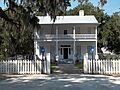
Ashantilly

Ashantilly is a historic home located near Darien. It was once the home of Thomas Spalding, an important person in Georgia's history. The original house was built around 1820. Sadly, it burned down in 1937 but was later rebuilt. It's also known as "Old Tabby" because of the building material used. Today, it's the Ashantilly Center, a place for learning and events.
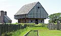
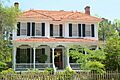
The Ridge
_(02).jpg)
The Ridge is a historic area in Ridgeville. It's a district with old roads and buildings that show how people lived long ago. It was added to the National Register in 1985.
Important Forts and Military Sites
Fort Barrington

Fort Barrington is an old fort site located northwest of Cox. It was an important military spot in the past. The actual fort site is on private land, but there is a historical marker nearby that tells its story. It was recognized as a historic place in 1972.
Fort King George

Fort King George is a very old fort located east of U.S. 17 in Darien. It was built a long time ago and played a big role in the early history of Georgia. Today, it is a Georgia state historic site. You can visit it and learn about what life was like for soldiers and settlers back then. It was added to the National Register in 1971.
Special Communities and Districts
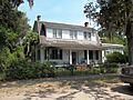
Hog Hammock Historic District

The Hog Hammock Historic District is a unique community on the east side of Sapelo Island. This area is special because it is one of the last remaining Gullah-Geechee communities in the United States. The Gullah-Geechee people are descendants of enslaved Africans who kept many of their traditional customs and language. This district was listed in 1996.
Vernon Square-Columbus Square Historic District

This historic district is located in Darien. It includes several important streets and squares. It was added to the National Register in 1985. This area shows the historic layout and buildings of Darien.
West Darien Historic District

Another important historic district in Darien is the West Darien Historic District. It covers an area bounded by 8th Street, US 17, the Darien River, and Cathead Creek. This district was recognized in 2001 for its historical significance.
Lighthouses and Islands
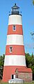
Sapelo Island Lighthouse

The Sapelo Island Lighthouse stands tall on the south end of Sapelo Island. Lighthouses are important because they guide ships safely to shore. This lighthouse has been helping sailors for many years. It was added to the National Register of Historic Places in 1997.
Other Historic Sites
Behavior Cemetery
Behavior Cemetery is a historic burial ground on the south end of Sapelo Island, near Hog Hammock. It was listed on the National Register in 1996.
First African Baptist Church at Raccoon Bluff
This historic church is on the east side of Sapelo Island, north of Hog Hammock. It is an important site for the community and was added to the National Register in 1996.
D'Antignac House
The D'Antignac House was once located on Baisden's Bluff on the Crescent River near Crescent. It was listed in 1977 but was later demolished in 2007.
Images for kids
-
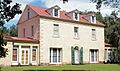
The beautiful Ashantilly house.
-
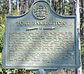
A historical marker for Fort Barrington.
-
The entrance to Fort King George.
-
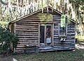
A home in the Hog Hammock Historic District.
-
A house on The Ridge in Ridgeville.
-
The Sapelo Island Lighthouse.
-
A view of the Vernon Square-Columbus Square Historic District in Darien.
-
A street view in the West Darien Historic District.
