
National Register of Historic Places listings in Habersham County, Georgia facts for kids
This article is about special places and areas in Habersham County, Georgia that are listed on the National Register of Historic Places (NRHP). These places are important because they tell us about the history of the area. They could be old houses, churches, stores, or even whole neighborhoods. Being on the NRHP means these sites are recognized for their historical or architectural importance and are often protected.
Contents
Historic Treasures in Habersham County
Habersham County is full of interesting historical sites. Many of these places are found in its towns, like Clarkesville, Cornelia, and Demorest. Let's explore some of these amazing spots!
Clarkesville's Historic Buildings
Clarkesville, the county seat, has many buildings listed on the National Register. These buildings show different styles of architecture from the past.
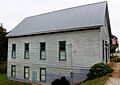
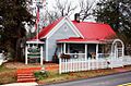
- Henry Asbury House: This house at 211 E. Waters St. was added to the list on August 18, 1982. It's a great example of older homes in the area.

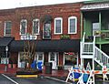
- Baron-York Building: Located at 714 N. Washington St., this building also became historic on August 18, 1982. It's a reminder of Clarkesville's commercial past.

- Church Furniture Store: Found on N. Washington St., this store was listed on August 18, 1982. It shows what local businesses were like long ago.
- Clarkesville Garage: At 304 N. Washington St., this garage joined the list on August 18, 1982. It tells a story about early transportation and businesses.
- Cornelius Church House: Also at 304 N. Washington St., this house was listed on August 18, 1982.
- Daes Chapel Methodist Church: This church on N. Washington St. was recognized on August 18, 1982. Churches often play a big role in a community's history.
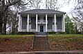
- Furr-Lambert House: Located at 223 Grant St., this house was added on August 18, 1982.

- Grace Church: Found at the corner of Wilson and Greene Sts., this church was listed earlier, on February 15, 1980.
,_HABERSHAM_COUNTY.jpg)
- Griggs-Erwin House: This house on Bridge St. was listed on August 18, 1982.

- Haywood English Family Log House: This unique log house is located west of Clarkesville on GA 115. It was listed on December 19, 1991, showing an older style of building.

- A. P. Hill House: On N. Washington St., this house was listed on August 18, 1982.
- Jackson Building: At 710 N. Washington St., this building was added on August 18, 1982.

- Jackson Pharmacy: Right next door at 712 N. Washington St., this pharmacy was also listed on August 18, 1982.

- J. A. Lewis House: Another historic home on N. Washington St., listed on August 18, 1982.
- Market Building: On N. Washington St., this building was listed on August 18, 1982. It likely served as a central place for trade.
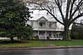
- Mauldin House: At 102 E. Water St., this house joined the list on August 18, 1982.

- Robert McMillan House: Located on Allen Lane, this house was listed on August 18, 1982.
- McMillan-Garrison House: At 403 S. Washington St., this house was added on August 18, 1982.
- Porter-York House: On Bridge St., this house was listed on August 18, 1982.

- Reeves Building: On N. Washington St., this building was listed on August 18, 1982.
- Woodlands and Blythewood: These properties are about 3 miles north of Clarkesville off U.S. 441. They were listed earlier, on December 30, 1975.
Historic Districts in Clarkesville
Some areas are so full of historic buildings that the entire neighborhood becomes a "historic district."
- South Washington Street Historic District: This district includes S. Washington St. between Laurel Dr. and Spring St. It was listed on August 18, 1982. This means many buildings in this area are historically important.
- Washington-Jefferson Street Historic District: This larger district covers Washington, Jefferson, and Wilson Sts. between Green St. and Laurel Dr. It was also listed on August 18, 1982.
Cornelia's Notable Places
The city of Cornelia also has several important historic sites.
- Chenocetah Fire Tower: Located on Chenocetah Mountain, this fire tower was listed on June 11, 1984. Fire towers were crucial for spotting forest fires.

- Cornelia Community House: Found at U.S. 123 at LaVista Lane, this community house was listed on June 21, 1982. Community houses are often places where people gather for events.

- Irvin General Merchandise Store: On Irvin St., this store was listed on July 26, 1984. General stores were once the main shopping places in small towns.
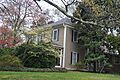
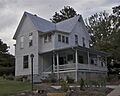
- Loudermilk Boarding House: At 271 Foreacre St., this boarding house was listed on February 9, 2001. Boarding houses provided temporary homes for travelers or workers.

Demorest's Historic Sites
Demorest is another town with its own unique history.
- Demorest Commercial Historic District: This district includes Georgia St. and Central Ave. It was listed on October 16, 1989. This area shows the history of businesses in Demorest.
- Demorest Women's Club: Located at 1035 Central Ave., this club was listed on December 30, 2008. Women's clubs often played a big role in community development and social causes.

- Pyle-Davis House: At 202 Massachusetts Blvd., this house was listed on June 23, 2003.

Other Historic Places in Habersham County
Beyond the main towns, other important sites are scattered throughout the county.
- Acoa: Located on Mathis Rd. in Hollywood, this site was listed on June 22, 1982.
- Glen-Ella Springs Hotel: Southwest of Tallulah Falls on Co. Rd. 218 in Turnerville, this hotel was listed on January 4, 1990. Historic hotels often have interesting stories about the people who stayed there.
- Lawton Place: At 136 7th St. in Mount Airy, this place was listed on January 8, 2009.
- Olgetree Farm: At the junction of Pea Ridge Rd. and Paradise Park Rd. in View, this farm was listed on July 9, 1997. Farms are important for understanding the agricultural history of an area.
- Tallulah Falls School: At the junction of US 441 and Tallulah School Rd. in Tallulah Falls, this school was listed on January 30, 1992. Schools are key parts of a community's history and growth.

Images for kids
-
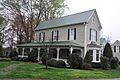
The historic Henry Asbury House in Clarkesville.
-
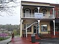
The Baron-York Building, a historic commercial building.
-
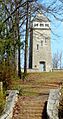
The Chenocetah Fire Tower.
-
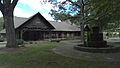
The Cornelia Community House.
-
The Demorest Women's Club building.
-
The Furr-Lambert House.
-
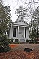
Grace Church, also known as Calvary Episcopal.
-
The Griggs-Erwin House.
-
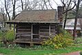
The Haywood English Family Log House.
-
The Jackson Building.
-
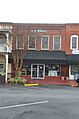
The Jackson Pharmacy.
-
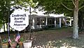
The Loudermilk Boarding House.
-
The Mauldin House.
-
The Porter-York House.
-
The Pyle-Davis House.
-
The Tallulah Falls School.
