
National Register of Historic Places listings in Bartow County, Georgia facts for kids
Bartow County, Georgia, is a place rich in history! Many buildings and areas here are so special that they are listed on the National Register of Historic Places (NRHP). This is like a special list kept by the United States government. It helps protect important places that tell us about America's past. When a place is on this list, it means it's a valuable part of history and should be preserved for everyone to learn from and enjoy.
Contents
- What is the National Register of Historic Places?
- Exploring Historic Sites in Bartow County
- Adairsville Historic District
- ATCO-Goodyear Mill and Mill Village Historic District
- Bartow County Courthouse
- Etowah Mounds: Ancient History
- Cassville Post Office
- Noble Hill School: A Place of Learning
- Roselawn: A Historic Home
- Pine Log Methodist Church, Campground, and Cemetery
- Cartersville's Downtown History
- Other Notable Places
- Images for kids
What is the National Register of Historic Places?
The National Register of Historic Places is the official list of the nation's historic places worth saving. It includes buildings, sites, structures, objects, and even entire neighborhoods. These places are important because they show us how people lived, worked, and built things in the past. They can also be important because of famous events that happened there or famous people who lived there.
Being on the NRHP encourages people to protect these places. It also helps communities celebrate their unique history. Bartow County has many such treasures, from ancient Native American sites to old courthouses and historic neighborhoods.
Exploring Historic Sites in Bartow County
Bartow County is home to many fascinating places that have been added to the National Register of Historic Places. Each one tells a unique story about the area's past. Let's explore some of them!
Adairsville Historic District

The Adairsville Historic District is a special area in Adairsville. It includes many old buildings, especially along Main Street. These buildings show what a busy town center looked like many years ago. Walking through this district is like taking a step back in time to see the town's early days. It was added to the NRHP in 1987.
ATCO-Goodyear Mill and Mill Village Historic District

Near Cartersville, you'll find the ATCO-Goodyear Mill and Mill Village Historic District. This area includes an old mill and the homes where the mill workers used to live. It's a great example of how factories and towns grew up together in the past. The mill provided jobs, and the village provided homes for the workers and their families. This district joined the NRHP in 2005.
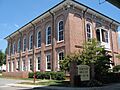
Bartow County Courthouse

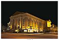
The Bartow County Courthouse is a grand building in the center of Cartersville. Courthouses are very important buildings because they are where laws are made and justice is served. This particular courthouse has been a central part of the community for a long time. It was recognized on the NRHP in 1980.
Etowah Mounds: Ancient History

The Etowah Mounds are one of the most amazing historic sites in Georgia. Located near Cartersville, these large earth mounds were built by Native Americans over a thousand years ago. They were part of a large city where thousands of people lived. The mounds served as platforms for important buildings and ceremonies. This site is so important that it's not just on the NRHP, but it's also a National Historic Landmark. It was listed in 1966.
Cassville Post Office

The Cassville Post Office is a historic building in Cassville. Post offices were once the main way people communicated across distances. This building reminds us of a time before emails and cell phones, when letters were the primary way to send messages. It was added to the NRHP in 1992.
Noble Hill School: A Place of Learning
The Noble Hill School is a very special place in Cassville. It was one of the first schools built specifically for African American children in Bartow County. Today, it is no longer a school but a museum. It helps people learn about the history of education and the challenges faced by different communities in the past. It became part of the NRHP in 1987.
Roselawn: A Historic Home

Roselawn is a beautiful historic home in Cartersville. It was built in the 1800s and has a rich history. Many important people have lived there, and the house itself is a great example of the architecture of its time. It was listed on the NRHP in 1973.
Pine Log Methodist Church, Campground, and Cemetery

The Pine Log Methodist Church, Campground, and Cemetery is a unique historic site near Rydal. It includes a church, a campground, and a cemetery. Campgrounds like this were important places for religious gatherings and community events in the past. This site was added to the NRHP in 1988.
Cartersville's Downtown History


Downtown Cartersville has not one, but several historic districts! These include the Cartersville Downtown Historic District, the North Erwin Street Historic District, and the North Wall Street Historic District. These areas are filled with old shops, offices, and homes that show how the city grew and developed over time. They are great places to explore and imagine what life was like in Cartersville's early days. These districts were listed between 1994 and 2014.
Other Notable Places
Bartow County has even more historic places on the National Register. These include:
- Benham Place: A historic home in Cartersville, listed in 1998.
- Rebecca Latimer Felton House: The home of a very important woman in Georgia history, located near Cartersville, listed in 1979.
- First Presbyterian Church: A beautiful church building in Cartersville, listed in 1991.
- Grand Theater: An old movie theater in Cartersville, listed in 1984, which still hosts events today.
- Corra White Harris House, Study, and Chapel: The home of a famous writer, located in Rydal, listed in 1997.
- Sam Jones Memorial United Methodist Church: Another historic church in Cartersville, listed in 1985.
- Old Bartow County Courthouse: An even older courthouse building in Cartersville, listed in 1980.
- Smith and Douglas Family Houses: Historic homes in Cassville, listed in 1999.
- Valley View: A historic property southwest of Cartersville, listed in 1974.
These places all contribute to the rich tapestry of Bartow County's past, helping us understand and appreciate the history around us.
Images for kids
-
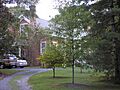
Benham Place
-
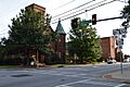
First Presbyterian Church of Cartersville
-
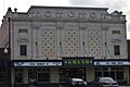
The Grand Theater in Cartersville
-
Sam Jones Memorial United Methodist Church
-
The Old Bartow County Courthouse
-
Smith and Douglas Family Houses


.JPG)

