
National Register of Historic Places listings in Hart County, Georgia facts for kids
This article is about special places in Hart County, Georgia that are listed on the National Register of Historic Places. These places are important because they tell us about the history of the area. They can be old houses, buildings, or even whole neighborhoods!
Contents
What is the National Register of Historic Places?
The National Register of Historic Places (NRHP) is like a special list of buildings, sites, and objects in the United States that are important to history. When a place is added to this list, it means it's recognized for its unique past, its beautiful design, or its connection to important events or people. It helps protect these places so future generations can learn from them.
Historic Homes and Buildings in Hart County
Many of the places on the list in Hart County are old homes and buildings. These structures often show us how people lived and worked a long time ago.
Hartwell's Historic Houses
The city of Hartwell has many historic houses. Here are some of them:
- Adams-Matheson House: Located at 116 Athens Street. It was added to the list in 1986.
- Allie M. Best House: Found at 122 Athens Street, also listed in 1986.
- Chandler-Linder House: This house is on Johnson Street and was listed in 1986.
- H. E. Fortson House: You can find this house at 221 Richardson Street, listed in 1986.
- Gulley-Vickery-Blackwell House: This home is at 115 Franklin Street, listed in 1986.
- Horton-Vickery House: Located at 101 Vickery Street, listed in 1986.
- Pearl J. Jones House: This house is at 401 Athens Street. It was added to the list in 1986.
- Kendrick-Matheson House: Located at 212 Athens Street, listed in 1986.
- Charles I. Kidd House: Found at 304 West Howell Street, listed in 1986.
- Roscoe Conklin Linder House: This home is at 118 Athens Street, listed in 1986.
- McCurry-Kidd House: Located at 602 West Howell Street, listed in 1986.
- Dr. Owen Meredith House: You can find this house at 605 Benson Street, listed in 1986.
- Jackson Morrison House: This home is at 439 Rome Street, listed in 1986.
- Emory Edward Satterfield House: Located at 504 West Howell Street, listed in 1986.
- Meyer Saul House: Found at 304 West Johnson Street, listed in 1986.
- Alexander Stephens Skelton House: This house is at 214 Athens Street, listed in 1986.
- Ralph Teasley House: Located at 421 West Howell Street, listed in 1986.
- Thomas William Teasley House: This home is at 417 West Howell Street, listed in 1986.
- Teasley-Holland House: Found at 416 West Howell Street, listed in 1986.
- John Roland Temple House: Located at 129 Athens Street, listed in 1986.
- Temple-Skelton House: This house is at 201 Athens Street, listed in 1986.
- John Underwood House: You can find this home at 825 South Jackson Street, listed in 1986.
Other Hart County Properties
- Archibald Mewborn House: This house is about 1 mile east of GA 172, 7 miles south of Hartwell. It was listed in 1997.
- Gulley-Gurley Farm: This farm is located at 1389 Lou Gurley Road in Bowersville. It was added to the list in 1997.
- Patterson-Turner Homeplace: This historic home is on Smith-McGee Bridge Road in Hartwell. It was listed in 1990.
Important Public and Commercial Buildings
Beyond homes, some public buildings and businesses are also recognized for their historical value.
- Franklin Light and Power Company Steam Generating Station: This old power station is on Leard Street at the railroad tracks in Hartwell. It was listed in 1986.
- Hart County Jail: The old jail building on Johnson Street in Hartwell was listed in 1985.
- Hartwell City School: The historic school building on College Avenue in Hartwell was listed in 1986.
- Hartwell Methodist Episcopal Church, South: This church on Howell Street in Hartwell was listed in 1986.
- Pure Oil Service Station: An old gas station located at Howell Street at Jackson Street in Hartwell. It was listed in 1986.
Historic Districts: Whole Neighborhoods with a Story
A "historic district" is a whole area or neighborhood that has many historic buildings. These districts are important because they show how a town or city grew and changed over time.
- Benson Street-Forest Avenue Residential Historic District: This district in Hartwell includes homes along Benson Street and Forest Avenue. It was listed in 1986.
- Bowersville Historic District: This district covers East and West Main Street in Bowersville. It was listed in 1985.
- Franklin Street-College Avenue Residential Historic District: This area in Hartwell is roughly bounded by Johnson, Maple, Franklin, First, and Carter Streets. It was listed in 1986.
- Hartwell Commercial Historic District: This district includes the main business area of Hartwell, bounded by Franklin Street, Forest Avenue, Railroad Street, and Jackson and Carolina Streets. It was listed in 1986.
- Witham Cotton Mills Village Historic District: This historic neighborhood in Hartwell is along Liberty Circle, Jackson, and Webb Streets. It was listed in 1986.
Images for kids
-
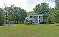
The Pearl J. Jones House in Hartwell, Georgia.

