
Nevada County, California facts for kids
Quick facts for kids
Nevada County
|
||
|---|---|---|
| County of Nevada | ||
    Images, from top down, left to right: Downtown Nevada City, Donner Lake, a scene in Rough and Ready, the Bridgeport Covered Bridge
|
||
|
||
| Motto(s):
"We're Better Together"
|
||

Location in the state of California
|
||
| Country | United States | |
| State | California | |
| Region | Sierra Nevada | |
| Metropolitan area | Greater Sacramento | |
| Incorporated | April 25, 1851 | |
| Named for | Nevada City, which is named after the Spanish word for "snow-covered" | |
| County seat | Nevada City | |
| Largest town | Truckee | |
| Government | ||
| • Type | Council–CEO | |
| Area | ||
| • Total | 974 sq mi (2,520 km2) | |
| • Land | 958 sq mi (2,480 km2) | |
| • Water | 16 sq mi (40 km2) | |
| Highest elevation | 9,152 ft (2,790 m) | |
| Population
(2020)
|
||
| • Total | 102,241 | |
| • Density | 104.97/sq mi (40.529/km2) | |
| GDP | ||
| • Total | $5.393 billion (2022) | |
| Time zone | UTC-8 (Pacific Time Zone) | |
| • Summer (DST) | UTC-7 (Pacific Daylight Time) | |
| Area code | 530 | |
| FIPS code | 06-057 | |
| GNIS feature ID | 1682927 | |

Nevada County is a county in the U.S. state of California. It is located in the beautiful Sierra Nevada mountains. In 2020, about 102,241 people lived there. The main city and county seat is Nevada City. Nevada County is part of a larger area that includes Truckee and Grass Valley. It is also part of the Sacramento region.
Contents
History of Nevada County


Nevada County was created in 1851. It was formed from parts of Yuba County. The county got its name from the mining town of Nevada City. The name "Nevada" comes from a Spanish word meaning "snowy" or "snow-covered." This name fits well because of the nearby Sierra Nevada Mountains.
Charles Marsh was an early settler in Nevada City. He helped name the town. He also built many water systems in the area. He was important in building the first transcontinental railroad. He also helped build the Nevada County Narrow Gauge Railroad.
Nevada City was the first place to use the name "Nevada." In 1851, the new county took the same name. Later, in 1864, the nearby state of Nevada also used this name.
The Gold Rush Era
The county became very active during the Gold Rush of 1849. Many historical places still exist from this exciting time.
- The Nevada Theatre in Nevada City was built in 1865. It is the oldest theater in California and is still open today. Famous people like Mark Twain once visited it.
- The Old 5 Mile House stagecoach stop was built in 1890. It still welcomes visitors today. It even has an old "stagecoach safe" outside. This safe has many stories about gold rush robbers.
- Gold mining continued to be important in Nevada County even after World War II.

Technological Firsts
Nevada County has a history of important inventions and "firsts":
- The world's first long-distance telephone line was built here in 1877. It connected French Corral with French Lake, about 58 miles (93 km) away.
- The Pelton wheel was invented to power gold mines. This invention still helps create electricity today.
- Nevada City and Grass Valley were among the first towns in California to have electric lights.
- The Grass Valley Group, founded in Grass Valley, designs and makes video equipment. This equipment is used by the Olympics, NASA, and many TV stations.
Railroads and Hotels
The Nevada County Narrow Gauge Railroad was built in 1876. It was special because it was never robbed, even though it carried a lot of gold. The owner, John Flint Kidder, was known for being very tough. This railroad closed in 1942.
The historic Holbrooke Hotel in Grass Valley opened in 1851. Many famous people stayed there, including Mark Twain and four U.S. Presidents: Ulysses S. Grant, Grover Cleveland, Benjamin Harrison, and James A. Garfield.
Unique Moments
The community of Rough and Ready once tried to become its own country! For a short time, it was called the Great Republic of Rough and Ready.
Nevada County is also home to the Empire Mine State Historic Park. This park has one of California's oldest, deepest, and richest gold mines. The mine operated for over 100 years. It produced 5.8 million ounces of gold before closing in 1956.
Boundary Dispute with Sierra County
For many years, there was a disagreement about the border between Nevada County and Sierra County. The law describing the border was hard to understand. This meant that a strip of land, about 31 square miles (80 square kilometers), was claimed by both counties. The California Supreme Court finally decided the border in 1908.
Geography and Environment
Nevada County covers about 974 square miles (2,520 square kilometers). About 16 square miles (41 square kilometers) of this area is water. The county has rivers like the Middle and South Yuba River.
The western part of the county follows the paths of several rivers. A special rectangular section was added to the county. This was done so the county could include the transcontinental railroad and the town of Truckee.
Nevada County is one of only four counties in the United States that borders a state with the same name (Nevada).
Ecology and Nature
Nevada County has many beautiful natural areas. These include large forests, grasslands, and areas along rivers. You can find different types of trees, like pine and oak. Many wildflowers also grow here, including the yellow mariposa lily.
Neighboring Counties
- Sierra County - to the north
- Washoe County, Nevada - to the east
- Placer County - to the south
- Yuba County - to the west
Protected Natural Areas
- Tahoe National Forest (part of it)
- Toiyabe National Forest (part of it)
Climate in Nevada County
Nevada County has different climates depending on where you are. Areas like Grass Valley have warm summers and mild, wet winters. Higher elevation areas, like Soda Springs and Truckee, have much colder winters with a lot of snow. Summers there are cooler.
| Climate data for Grass Valley, California, 1991–2020 normals, extremes 1966–present | |||||||||||||
|---|---|---|---|---|---|---|---|---|---|---|---|---|---|
| Month | Jan | Feb | Mar | Apr | May | Jun | Jul | Aug | Sep | Oct | Nov | Dec | Year |
| Record high °F (°C) | 77 (25) |
81 (27) |
82 (28) |
88 (31) |
99 (37) |
102 (39) |
108 (42) |
108 (42) |
108 (42) |
97 (36) |
87 (31) |
80 (27) |
108 (42) |
| Mean daily maximum °F (°C) | 53.6 (12.0) |
54.9 (12.7) |
57.9 (14.4) |
62.7 (17.1) |
70.8 (21.6) |
80.2 (26.8) |
88.0 (31.1) |
87.4 (30.8) |
82.3 (27.9) |
72.1 (22.3) |
59.8 (15.4) |
52.6 (11.4) |
68.5 (20.3) |
| Daily mean °F (°C) | 43.4 (6.3) |
44.5 (6.9) |
47.5 (8.6) |
51.3 (10.7) |
58.8 (14.9) |
66.4 (19.1) |
73.1 (22.8) |
72.1 (22.3) |
67.2 (19.6) |
58.2 (14.6) |
48.4 (9.1) |
42.6 (5.9) |
56.1 (13.4) |
| Mean daily minimum °F (°C) | 33.1 (0.6) |
34.2 (1.2) |
37.0 (2.8) |
40.0 (4.4) |
46.8 (8.2) |
52.6 (11.4) |
58.2 (14.6) |
56.8 (13.8) |
52.1 (11.2) |
44.2 (6.8) |
37.1 (2.8) |
32.6 (0.3) |
43.7 (6.5) |
| Record low °F (°C) | 10 (−12) |
9 (−13) |
19 (−7) |
20 (−7) |
22 (−6) |
28 (−2) |
35 (2) |
41 (5) |
25 (−4) |
25 (−4) |
19 (−7) |
3 (−16) |
3 (−16) |
| Average precipitation inches (mm) | 9.30 (236) |
8.98 (228) |
8.16 (207) |
4.43 (113) |
2.48 (63) |
0.74 (19) |
0.00 (0.00) |
0.11 (2.8) |
0.44 (11) |
2.56 (65) |
5.52 (140) |
10.48 (266) |
53.20 (1,351) |
| Average snowfall inches (cm) | 0.7 (1.8) |
3.0 (7.6) |
3.0 (7.6) |
0.5 (1.3) |
0.0 (0.0) |
0.0 (0.0) |
0.0 (0.0) |
0.0 (0.0) |
0.0 (0.0) |
0.0 (0.0) |
0.2 (0.51) |
1.2 (3.0) |
8.6 (21.81) |
| Average precipitation days (≥ 0.01 in) | 12.8 | 11.7 | 12.2 | 8.5 | 5.9 | 2.7 | 0.2 | 0.8 | 1.6 | 4.4 | 8.4 | 12.3 | 81.5 |
| Average snowy days (≥ 0.1 in) | 0.3 | 1.0 | 1.0 | 0.3 | 0.0 | 0.0 | 0.0 | 0.0 | 0.0 | 0.0 | 0.1 | 0.3 | 3 |
| Source 1: NOAA | |||||||||||||
| Source 2: National Weather Service | |||||||||||||
| Climate data for Soda Springs, California, 1991–2020 normals, extremes 1913–1959 | |||||||||||||
|---|---|---|---|---|---|---|---|---|---|---|---|---|---|
| Month | Jan | Feb | Mar | Apr | May | Jun | Jul | Aug | Sep | Oct | Nov | Dec | Year |
| Record high °F (°C) | 61 (16) |
65 (18) |
64 (18) |
72 (22) |
79 (26) |
88 (31) |
91 (33) |
88 (31) |
92 (33) |
78 (26) |
72 (22) |
67 (19) |
92 (33) |
| Mean daily maximum °F (°C) | 36.9 (2.7) |
39.2 (4.0) |
42.9 (6.1) |
49.5 (9.7) |
55.9 (13.3) |
64.4 (18.0) |
73.8 (23.2) |
73.4 (23.0) |
68.3 (20.2) |
57.9 (14.4) |
47.5 (8.6) |
40.7 (4.8) |
54.2 (12.3) |
| Daily mean °F (°C) | 24.9 (−3.9) |
26.5 (−3.1) |
30.0 (−1.1) |
36.7 (2.6) |
43.1 (6.2) |
51.1 (10.6) |
59.0 (15.0) |
57.7 (14.3) |
53.4 (11.9) |
44.8 (7.1) |
35.0 (1.7) |
28.1 (−2.2) |
40.9 (4.9) |
| Mean daily minimum °F (°C) | 12.6 (−10.8) |
13.6 (−10.2) |
17.1 (−8.3) |
23.9 (−4.5) |
30.3 (−0.9) |
37.8 (3.2) |
44.2 (6.8) |
42.0 (5.6) |
37.9 (3.3) |
31.0 (−0.6) |
22.0 (−5.6) |
15.3 (−9.3) |
27.3 (−2.6) |
| Record low °F (°C) | −24 (−31) |
−28 (−33) |
−20 (−29) |
−10 (−23) |
2 (−17) |
21 (−6) |
23 (−5) |
24 (−4) |
20 (−7) |
6 (−14) |
−6 (−21) |
−17 (−27) |
−28 (−33) |
| Average precipitation inches (mm) | 13.16 (334) |
12.26 (311) |
12.14 (308) |
6.99 (178) |
4.74 (120) |
1.57 (40) |
0.43 (11) |
0.45 (11) |
0.99 (25) |
3.89 (99) |
7.57 (192) |
14.35 (364) |
78.54 (1,993) |
| Average snowfall inches (cm) | 73.0 (185) |
84.2 (214) |
105.7 (268) |
41.2 (105) |
15.6 (40) |
1.8 (4.6) |
0.0 (0.0) |
0.0 (0.0) |
1.5 (3.8) |
9.9 (25) |
42.8 (109) |
69.3 (176) |
445.0 (1,130) |
| Average extreme snow depth inches (cm) | 74 (190) |
90 (230) |
108 (270) |
90 (230) |
46 (120) |
15 (38) |
0 (0) |
0 (0) |
1 (2.5) |
6 (15) |
17 (43) |
49 (120) |
118 (300) |
| Average precipitation days (≥ 0.01 in) | 12.2 | 11.6 | 15.9 | 11.2 | 10.8 | 5.5 | 1.8 | 2.8 | 3.8 | 5.9 | 9.3 | 14.1 | 104.9 |
| Average snowy days (≥ 0.1 in) | 10.0 | 10.6 | 13.5 | 7.7 | 3.6 | 0.7 | 0.0 | 0.0 | 0.6 | 1.8 | 6.7 | 11.5 | 66.7 |
| Source: NOAA | |||||||||||||
| Climate data for Truckee, California (Truckee Ranger Station), 1991–2020 normals, extremes 1904–2009 | |||||||||||||
|---|---|---|---|---|---|---|---|---|---|---|---|---|---|
| Month | Jan | Feb | Mar | Apr | May | Jun | Jul | Aug | Sep | Oct | Nov | Dec | Year |
| Record high °F (°C) | 64 (18) |
68 (20) |
73 (23) |
83 (28) |
92 (33) |
94 (34) |
100 (38) |
101 (38) |
95 (35) |
87 (31) |
82 (28) |
66 (19) |
101 (38) |
| Mean daily maximum °F (°C) | 41.8 (5.4) |
44.5 (6.9) |
49.6 (9.8) |
54.8 (12.7) |
64.3 (17.9) |
74.8 (23.8) |
83.8 (28.8) |
83.8 (28.8) |
76.2 (24.6) |
64.6 (18.1) |
50.9 (10.5) |
40.5 (4.7) |
60.8 (16.0) |
| Daily mean °F (°C) | 28.9 (−1.7) |
31.1 (−0.5) |
35.4 (1.9) |
40.0 (4.4) |
47.8 (8.8) |
55.3 (12.9) |
62.6 (17.0) |
62.1 (16.7) |
55.2 (12.9) |
46.0 (7.8) |
36.0 (2.2) |
27.8 (−2.3) |
44.0 (6.7) |
| Mean daily minimum °F (°C) | 16.1 (−8.8) |
17.6 (−8.0) |
21.2 (−6.0) |
25.2 (−3.8) |
31.4 (−0.3) |
35.8 (2.1) |
41.4 (5.2) |
40.3 (4.6) |
34.1 (1.2) |
27.5 (−2.5) |
21.2 (−6.0) |
15.0 (−9.4) |
27.2 (−2.6) |
| Record low °F (°C) | −28 (−33) |
−23 (−31) |
−18 (−28) |
1 (−17) |
6 (−14) |
18 (−8) |
15 (−9) |
20 (−7) |
16 (−9) |
4 (−16) |
−14 (−26) |
−22 (−30) |
−28 (−33) |
| Average precipitation inches (mm) | 5.68 (144) |
5.09 (129) |
4.46 (113) |
2.13 (54) |
1.49 (38) |
0.57 (14) |
0.26 (6.6) |
0.53 (13) |
0.63 (16) |
1.77 (45) |
2.81 (71) |
5.15 (131) |
30.57 (774.6) |
| Average snowfall inches (cm) | 43.6 (111) |
47.9 (122) |
32.2 (82) |
18.5 (47) |
4.1 (10) |
0.9 (2.3) |
0.0 (0.0) |
0.0 (0.0) |
0.5 (1.3) |
2.8 (7.1) |
11.9 (30) |
44.2 (112) |
206.6 (524.7) |
| Average precipitation days | 11.9 | 11.0 | 10.0 | 9.4 | 7.3 | 3.2 | 1.9 | 2.0 | 2.8 | 4.9 | 7.7 | 11.6 | 83.7 |
| Average snowy days | 8.7 | 8.1 | 6.8 | 5.4 | 1.6 | 0.3 | 0.0 | 0.0 | 0.2 | 1.2 | 3.7 | 7.8 | 43.8 |
| Source 1: NOAA | |||||||||||||
| Source 2: WRCC (mean maxima and minima 1904–2009) | |||||||||||||
| Climate data for Bowman Dam, California (5400 feet) | |||||||||||||
|---|---|---|---|---|---|---|---|---|---|---|---|---|---|
| Month | Jan | Feb | Mar | Apr | May | Jun | Jul | Aug | Sep | Oct | Nov | Dec | Year |
| Record high °F (°C) | 75 (24) |
78 (26) |
83 (28) |
88 (31) |
93 (34) |
100 (38) |
102 (39) |
99 (37) |
98 (37) |
90 (32) |
82 (28) |
72 (22) |
102 (39) |
| Mean daily maximum °F (°C) | 46.6 (8.1) |
47.6 (8.7) |
49.9 (9.9) |
56.1 (13.4) |
64.0 (17.8) |
73.5 (23.1) |
81.6 (27.6) |
81.9 (27.7) |
76.3 (24.6) |
65.5 (18.6) |
53.1 (11.7) |
45.8 (7.7) |
61.8 (16.6) |
| Daily mean °F (°C) | 37.0 (2.8) |
37.1 (2.8) |
39.1 (3.9) |
43.9 (6.6) |
51.3 (10.7) |
60.0 (15.6) |
67.3 (19.6) |
67.5 (19.7) |
62.6 (17.0) |
53.2 (11.8) |
42.8 (6.0) |
36.7 (2.6) |
49.9 (9.9) |
| Mean daily minimum °F (°C) | 27.3 (−2.6) |
26.5 (−3.1) |
28.2 (−2.1) |
31.7 (−0.2) |
38.3 (3.5) |
46.4 (8.0) |
53.0 (11.7) |
53.1 (11.7) |
48.9 (9.4) |
41.0 (5.0) |
32.6 (0.3) |
27.6 (−2.4) |
37.9 (3.3) |
| Record low °F (°C) | −3 (−19) |
−2 (−19) |
4 (−16) |
7 (−14) |
12 (−11) |
25 (−4) |
32 (0) |
30 (−1) |
21 (−6) |
18 (−8) |
11 (−12) |
0 (−18) |
−3 (−19) |
| Average precipitation inches (mm) | 11.91 (303) |
10.94 (278) |
9.60 (244) |
4.85 (123) |
3.30 (84) |
1.20 (30) |
0.19 (4.8) |
0.37 (9.4) |
1.00 (25) |
4.04 (103) |
7.89 (200) |
10.47 (266) |
65.76 (1,670.2) |
| Average snowfall inches (cm) | 40.9 (104) |
41.7 (106) |
42.2 (107) |
17.1 (43) |
3.0 (7.6) |
0.0 (0.0) |
0.0 (0.0) |
0.0 (0.0) |
0.0 (0.0) |
1.5 (3.8) |
16.1 (41) |
36.0 (91) |
198.5 (503.4) |
| Average precipitation days | 12.8 | 11.7 | 12.2 | 8.5 | 5.9 | 2.7 | 0.2 | 0.8 | 1.6 | 4.4 | 8.4 | 12.3 | 81.5 |
| Source: NOAA | |||||||||||||
People of Nevada County
| Historical population | |||
|---|---|---|---|
| Census | Pop. | %± | |
| 1860 | 16,446 | — | |
| 1870 | 19,134 | 16.3% | |
| 1880 | 20,823 | 8.8% | |
| 1890 | 17,369 | −16.6% | |
| 1900 | 17,789 | 2.4% | |
| 1910 | 14,955 | −15.9% | |
| 1920 | 10,850 | −27.4% | |
| 1930 | 10,596 | −2.3% | |
| 1940 | 19,283 | 82.0% | |
| 1950 | 19,888 | 3.1% | |
| 1960 | 20,911 | 5.1% | |
| 1970 | 26,346 | 26.0% | |
| 1980 | 51,645 | 96.0% | |
| 1990 | 78,510 | 52.0% | |
| 2000 | 92,033 | 17.2% | |
| 2010 | 98,764 | 7.3% | |
| 2020 | 102,241 | 3.5% | |
| 2023 (est.) | 102,037 | 3.3% | |
| U.S. Decennial Census 1790–1960 1900–1990 1990–2000 2010 2020 |
|||
Population and Diversity
As of the 2020 census, Nevada County had 102,241 residents. Most people in the county are White. However, the county is also home to people of many different backgrounds. This includes Black or African American, Native American, Asian, and Pacific Islander people. Many residents also identify as Hispanic or Latino.
| Race / Ethnicity (NH = Non-Hispanic) | Pop 2000 | Pop 2010 | Pop 2020 | % 2000 | % 2010 | % 2020 |
|---|---|---|---|---|---|---|
| White alone (NH) | 83,098 | 85,477 | 82,810 | 90.29% | 86.55% | 80.99% |
| Black or African American alone (NH) | 234 | 341 | 416 | 0.25% | 0.35% | 0.41% |
| Native American or Alaska Native alone (NH) | 663 | 793 | 695 | 0.72% | 0.80% | 0.68% |
| Asian alone (NH) | 702 | 1,124 | 1,371 | 0.76% | 1.14% | 1.34% |
| Pacific Islander alone (NH) | 70 | 96 | 119 | 0.08% | 0.10% | 0.12% |
| Other race alone (NH) | 175 | 122 | 617 | 0.19% | 0.12% | 0.60% |
| Mixed race or Multi-racial (NH) | 1,890 | 2,372 | 5,797 | 2.05% | 2.40% | 5.67% |
| Hispanic or Latino (any race) | 5,201 | 8,439 | 10,416 | 5.65% | 8.54% | 10.19% |
| Total | 92,033 | 98,764 | 102,241 | 100.00% | 100.00% | 100.00% |
In 2000, the average household income was about $45,864. For families, it was about $52,697. The average income per person was about $24,007. A small percentage of families and people lived below the poverty line.
Getting Around Nevada County
Main Roads
 Interstate 80
 State Route 20
 State Route 49
 State Route 89
 State Route 174
Public Transport Options
- Gold Country Stage runs local bus services in Grass Valley, Nevada City, and nearby towns. You can also connect to Auburn in Placer County.
- Tahoe Area Rapid Transit connects Truckee to Lake Tahoe and Nevada. Truckee also has its own local bus.
- Greyhound buses and Amtrak trains (the California Zephyr) stop in Truckee and Colfax.
- YubaBus offers charter and shuttle bus services in the western part of the county.
- Gold Country Lift provides special door-to-door bus service for seniors and people with disabilities.
Airports in the County
- Nevada County Air Park is a small airport near Grass Valley.
- Truckee Tahoe Airport is another small airport located partly in Truckee and partly in Placer County.
- Alta Sierra Airport is a private airport south of Grass Valley.
Communities in Nevada County
Cities in the County
- Grass Valley
- Nevada City (This is the county seat, where the main government offices are.)
Town in the County
Census-Designated Places (CDPs)
These are areas that are like towns but are not officially incorporated as cities.
Other Unincorporated Communities
These are smaller communities that are not officially part of a city or CDP.
- Anthony House
- Birchville
- Blue Tent
- Boca
- Boreal
- Cedar Ridge
- Cherokee Township
- Chicago Park
- French Corral
- Lake City
- Malakoff Diggings
- Moores Flat
- Nevada City Rancheria
- Norden
- North Bloomfield
- North Columbia
- Ophir Hill
- Peardale
- Ready Springs
- Sunset District
- Sweetland
- You Bet
- Wolf
Ghost Town
- Meadow Lake (also known as Excelsior or Summit City)
Community Population Ranking (2010)
This table shows the population of the main communities in Nevada County based on the 2010 census.
† county seat
| Rank | City/Town/etc. | Municipal type | Population (2010 Census) |
|---|---|---|---|
| 1 | Truckee | Town | 16,180 |
| 2 | Grass Valley | City | 12,860 |
| 3 | Alta Sierra | CDP | 6,911 |
| 4 | Lake Wildwood | CDP | 4,991 |
| 5 | Lake of the Pines | CDP | 3,917 |
| 6 | † Nevada City | City | 3,068 |
| 7 | Penn Valley | CDP | 1,621 |
| 8 | Rough and Ready | CDP | 963 |
| 9 | North San Juan | CDP | 269 |
| 10 | Washington | CDP | 185 |
| 11 | Kingvale (partially in Placer County) | CDP | 143 |
| 12 | Soda Springs | CDP | 81 |
| 13 | Floriston | CDP | 73 |
| 14 | Graniteville | CDP | 11 |
Famous People from Nevada County
Many interesting people have lived in or have ties to Nevada County:
- Jennie Carter (19th Century writer and journalist)
- Lyman Gilmore (early aircraft developer, some believe he flew before the Wright brothers)
- Roger Hodgson (founding member of the rock band Supertramp)
- Herbert Hoover (U.S. President, lived in Nevada City as a young engineer)
- Charles Litton Sr. (inventor who helped develop the magnetron tube)
- Mark Meckler (co-founder of the Tea Party Patriots)
- Gertrude Penhall (civic leader and early settler)
- Utah Phillips (folk singer)
- Edwin W. Reimers (former actor and TV announcer)
- Gary Snyder (Beat Poet)
- Clint Walker (actor)
- Ricky Williams (National Football League star)
- Chuck Yeager (pilot, first person to break the sound barrier)
- John Christopher Stevens (U.S. Ambassador, born in Grass Valley)
- Joanna Newsom (multi-instrumentalist, singer-songwriter, and actress)
Images for kids
-
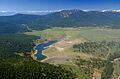
Martis Creek Lake and Dam at the southern edge of eastern Nevada County near Truckee: At full pool, the lake extends into Placer County in the distance to the south.
-
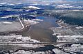
Martis Creek Lake and Dam in Nevada County: This picture was taken over Placer County, looking north into Nevada County.
-
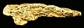
Gold nugget of about 6 troy ounces, from the Yuba River placers of Nevada County - size: 8.3 x 2.8 x 2.3 cm
See also
 In Spanish: Condado de Nevada (California) para niños
