Ooty facts for kids
Quick facts for kids
Ooty
Udagamandalam
|
|
|---|---|
|
Town
|
|
| Udagamandalam | |
|
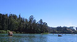
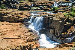
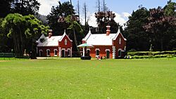
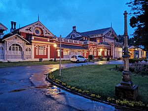
From top: Ooty Lake; Pykara falls and Government Botanical Garden
|
|
| Nickname(s):
Queen of hill stations
|
|
| Country | |
| State | Tamil Nadu |
| Region | Kongu Nadu |
| District | Nilgiris District |
| Government | |
| • Type | Special Grade Municipality |
| • Body | Udagamandalam Municipality |
| Area | |
| • Total | 30.36 km2 (11.72 sq mi) |
| Elevation | 2,240 m (7,350 ft) |
| Population
(2011)
|
|
| • Total | 88,430 |
| • Density | 2,912.7/km2 (7,543.9/sq mi) |
| Demonym(s) | Ootian, Ootacamandian, Udaghaikaran |
| Languages | |
| • Official | Tamil |
| Time zone | UTC+5:30 (IST) |
| PIN |
643001
|
| Tele | 91423 |
| Vehicle registration | TN-43 |
| Climate | Subtropical Highland (Köppen) |
| Precipitation | 1,100 mm (43 in) |
| Website | tnurbantree.tn.gov.in/ |
Ooty, officially known as Udagamandalam, is a beautiful town and municipality in the Nilgiris district of Tamil Nadu, India. It is located about 86 km (53 mi) northwest of Coimbatore. Ooty is the main town of the Nilgiris district.
This town is nestled in the Nilgiri hills. It is often called the "Queen of Hill Stations" because of its stunning natural beauty. Ooty is a very popular place for tourists to visit.
The Toda people originally lived in this area. In the 18th century, the East India Company took control. Later, Ooty became the summer capital for the Madras Presidency. Today, Ooty's economy relies on tourism and agriculture. You can reach the town by roads or by the special Nilgiri Mountain Railway.
Contents
Understanding Ooty's Name
The area was first known as Ottakal Mandu. In Tamil, Otha-Cal means "single stone". This refers to a special stone that the local Toda people respected. Mandu is a Toda word for "village".
This name later became Udagamandalam. The British changed it to Ootacamund. The first part, Ootaca, came from the local name. The second part, Mand, was a shorter version of the Toda word Mandu.
The first time the name Wotokymund was written was in March 1821. This was in a letter to the Madras Gazette. Later, Ootacamund was shortened to Ooty. Ooty is in the Nilgiri hills, which means "blue mountains". They got this name from the Kurunji flower. This flower used to make the hills look bluish.
A Glimpse into Ooty's Past
The earliest mentions of the Nilgiri hills are in ancient Tamil writings. These are found in the Sangam epic Silappathikaram from the 5th or 6th century CE. Many different tribes lived in this region. These included the Badagas, Todas, Kotas, Irulas, and Kurumbas.
Different Tamil kingdoms ruled the region over time. These were the Cheras, Cholas, and Pandyas. A record from 1117 CE mentions the Todas. It belongs to the Hoysala king Vishnuvardhana.
Various other dynasties also ruled here. These included the Pallavas and Vijayanagara empire. In the 18th century, Tipu Sultan took control of the Nilgiris. The British gained possession in 1799. It then became part of the Coimbatore district of the Madras Presidency.
In 1818, J. C. Whish and N. W. Kindersley visited nearby Kotagiri. They were assistants to John Sullivan. Sullivan was the collector of Coimbatore district. They saw that the region could be a great summer retreat.
Sullivan built his home there and reported to the government in 1819. He also started building a road from Sirumugai. This road was finished in May 1823. It was later extended to Coonoor between 1830 and 1832.
By 1827, Ooty became a health resort for the Madras Presidency. It grew even more with the help of Governor Stephen Lushington. The Government Botanical Garden was created in 1842. It covers 51 acres (21 ha). A library was also opened in 1959.
Ooty became a municipality in 1866. Many improvements were made, like new roads and better water supply. The Nilgiris region was separated from Coimbatore district in 1868. It became its own district in 1882.
By the early 1900s, Ooty was a well-developed hill station. It had an artificial lake, parks, and places of worship. There were also sports facilities for polo, golf, and cricket. It served as the summer capital for British officials. After India's independence, Ooty continued to be a popular hill resort.
Ooty's Natural Surroundings
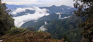
Ooty is located in the Nilgiri hills. These hills are part of the Western Ghats. They are also part of the Nilgiri Biosphere Reserve. The Moyar river separates Ooty from Karnataka to the north. The Palghat Gap separates it from the Anaimalai and Palani hills to the south.
Ooty is 2,240 metres (7,350 feet) above sea level. The town covers an area of 30.36 km2 (11.72 sq mi). Doddabetta is the highest peak in the Nilgiris. It is about 10 km (6.2 mi) from Ooty and stands at 2,623 m or 8,606 ft.
Ooty Lake is a man-made lake. It covers 65 acres (26 ha) and was created in 1824. The Pykara river is 19 km (12 mi) from Ooty. It starts at Mukurthi peak and flows through many waterfalls. The last two falls are 55 metres (180 ft) and 61 metres (200 ft) high. These are known as Pykara falls. Other lakes in the area include Kamaraj Sagar Dam, Emerald Lake, Avalanche Lake, and Porthimund Lake.
Ooty's Weather
Ooty has a subtropical highland climate. This means it has mild summers and cool winters. Because it is so high up, temperatures are generally lower than in the plains below.
In summer, the average temperature is between 10–25 °C (50–77 °F). In winter, it ranges from 0–21 °C (32–70 °F). The highest temperature ever recorded was 28.5 °C (83.3 °F). The lowest was −5.1 °C (22.8 °F).
The town gets a lot of rain during both the South-West and North-East monsoons. The average rainfall is about 1,100 millimetres (43 in) each year.
| Climate data for Ooty (Udagamandalam) | |||||||||||||
|---|---|---|---|---|---|---|---|---|---|---|---|---|---|
| Month | Jan | Feb | Mar | Apr | May | Jun | Jul | Aug | Sep | Oct | Nov | Dec | Year |
| Mean daily maximum °C (°F) | 20.3 (68.5) |
20.9 (69.6) |
22.2 (72.0) |
22.6 (72.7) |
22.0 (71.6) |
18.3 (64.9) |
16.9 (62.4) |
17.4 (63.3) |
18.4 (65.1) |
18.8 (65.8) |
18.7 (65.7) |
19.7 (67.5) |
19.7 (67.4) |
| Daily mean °C (°F) | 12.4 (54.3) |
13.6 (56.5) |
15.2 (59.4) |
16.3 (61.3) |
16.6 (61.9) |
14.8 (58.6) |
14.1 (57.4) |
14.4 (57.9) |
14.4 (57.9) |
14.6 (58.3) |
13.7 (56.7) |
12.9 (55.2) |
14.4 (58.0) |
| Mean daily minimum °C (°F) | 5.6 (42.1) |
6.5 (43.7) |
8.8 (47.8) |
10.7 (51.3) |
11.4 (52.5) |
11.2 (52.2) |
11.0 (51.8) |
10.9 (51.6) |
10.4 (50.7) |
10.1 (50.2) |
8.6 (47.5) |
6.7 (44.1) |
9.3 (48.8) |
| Average precipitation mm (inches) | 20.5 (0.81) |
10.2 (0.40) |
25.8 (1.02) |
75.4 (2.97) |
147.5 (5.81) |
136.7 (5.38) |
181.1 (7.13) |
123.7 (4.87) |
134.9 (5.31) |
189.2 (7.45) |
139.9 (5.51) |
52.8 (2.08) |
1,237.7 (48.74) |
| Average rainy days | 1 | 1 | 2 | 5 | 8 | 8 | 10 | 9 | 9 | 11 | 7 | 4 | 75 |
| Mean daily sunshine hours | 8 | 8 | 8 | 8 | 7 | 4 | 4 | 4 | 5 | 5 | 6 | 7 | 6 |
| Source 1: Indian Meteorological Department (1901–2000) | |||||||||||||
| Source 2: Climate-Data.org for mean temperatures, altitude: 2214 meters, Weather2Travel for sunshine and rainy days | |||||||||||||
Amazing Plants and Animals
Ooty is part of the Nilgiri Biosphere Reserve. This is India's largest protected forest area. It became a protected reserve in 1986. It is also part of UNESCO's "Man and the Biosphere Programme".
Mudumalai National Park and tiger reserve is to the northwest of Ooty. It is about 31 km (19 mi) away. This park was set up in 1940. It was the first wildlife sanctuary in India.
The region is part of the South Western Ghats montane rain forests. The Nilgiris have thousands of plant species. These include medicinal plants and plants found only here. Short evergreen trees grow in shola forest patches. These are found above 1,800 m (5,900 ft). They are covered with epiphytes (plants that grow on other plants).
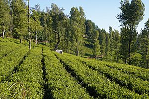
The original plants were Meadows and grasslands on the hills. Shola forests grew in the valleys. When the British settled here, they planted new trees. These included pine, wattle, and eucalyptus. They also started tea plantations. These new plants became very common.
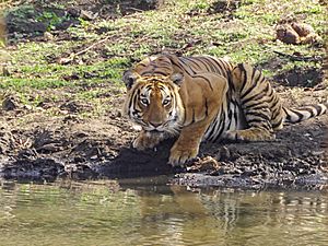
The region has one of the largest populations of bengal tigers. The Indian elephant is the biggest mammal here. The gaur is the largest ungulate (hoofed animal). It often visits grasslands near water.
Other large animals include the Indian leopard and sloth bear. Smaller animals are the Jungle cat and rusty-spotted cat. You can also find dhole (wild dogs) and Golden jackals. The Nilgiri marten and various civets live here too.
Animals like the wild boar and Indian pangolin are present. You might also see the Indian crested porcupine and Indian giant squirrel. Indian giant flying squirrels are seen near the Moyar River.
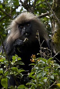
Deer species include sambar deer and chital. There are also Indian spotted chevrotain and Indian muntjac. Monkeys like the Nilgiri langur are found here. The Nilgiri langur is an endangered primate.
The Nilgiri tahr is an endangered ungulate. It is found only in the Nilgiris. It is also the state animal of Tamil Nadu. Bats live in the dark caves of the hills. More than 200 types of birds live in this region.
People and Languages
| Religious census | ||||
|---|---|---|---|---|
| Religion | Percent(%) | |||
| Hindu | 64.36% | |||
| Christian | 21.25% | |||
| Muslim | 13.37% | |||
| Other | 1.03% | |||
In 2011, Udagamandalam had a population of 88,430 people. There were 1,053 females for every 1,000 males. This is higher than the national average. About 7,781 children were under six years old.
Most people in Udagamandalam are Hindus (64.36%). There are also many Christians (21.25%) and Muslims (13.37%).
Tamil is the main language spoken in Udagamandalam. Other languages native to the Nilgiris are Badaga, Paniya, Irula, and Kurumba. Because Ooty is a tourist spot and near other states, Malayalam, Kannada, and English are also understood.
Ooty's Economy
Ooty is a market town for the areas around it. The local economy still relies a lot on agriculture. Farmers here grow vegetables like potatoes, carrots, cabbage, and cauliflower. They also grow fruits such as peaches, plums, pears, and strawberrys. There is a daily market where these products are sold.
Dairy farming has been important in the area for a long time. There is a cooperative dairy that makes cheese and milk powder. Growing flowers (floriculture) and raising silkworms (sericulture) are also done here. People also grow mushrooms.
The local area is famous for growing tea. Nilgiri tea is a special type of black tea unique to this region.
Other industries are located outside the town. The Human Biologicals Institute makes vaccines. In Ketti, needles are made, and in Aruvankadu, cordite (an explosive) is produced.
Getting Around Ooty
Road Travel
Ooty is connected by roads known as the Nilgiri Ghat Roads. It is located on NH 181. The town's roads are managed by the municipality.
Public bus services are run by the TNSTC. Other bus companies like SETC, KSRTC (Karnataka), and KSRTC (Kerala) connect Ooty to other towns and nearby states.
Train Travel
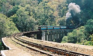
The Nilgiri Mountain Railway is a special train line. It connects Udagamandalam and Mettupalayam. The railway company was formed in 1885. The first part of the track opened in 1899.
The line from Coonoor to Ooty was finished in 1908. This railway is the only rack railway in India. It uses special steam locomotives. In 2005, UNESCO made the Nilgiri Mountain Railway a World Heritage Site.
Air Travel
The closest airport to Ooty is Coimbatore International Airport. It is about 96 km (60 mi) away. This airport has regular flights to major cities in India. It also has international flights to places like Sharjah, Colombo, and Singapore.
Ooty has three helipads for helicopters. One is at Theettukal and two at Kodanad. The Theettukal helipad is approved for defense and VIP services.
Learning in Ooty
Government Arts College is one of the oldest schools in Ooty. It was started in 1955. It is connected to Bharathiar University. There are also a few other colleges in the town.
Boarding schools have been a part of Ooty since the time of the British Raj. They are still open today. Some of these are among the most expensive schools in India.
Fun Things to Do in Ooty
There is a boat house at Ooty Lake. Tourists can enjoy boating there. Similar boating is also available at the Pykara falls and dam.
The Government Botanical Garden was created in 1842. It has many speciesnative and foreign plants. An annual flower show is held here in May. The garden also has a 20-million-year-old fossilized tree.
The Government Rose Garden is on Elk Hill. It has over 20,000 types of roses. It is the largest rose garden in India. A deer park was opened near the lake in 1986. It is the second-highest zoo in India.
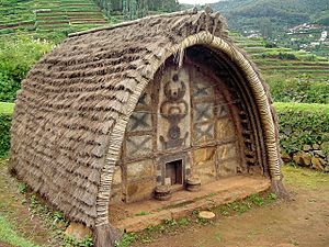
You can find some traditional Toda huts (dogles) on the hills above the Botanical Garden. A Tribal Museum opened in 1995. It is about 10 km (6.2 mi) from the town. It displays rare items and photos of tribal groups.
The Stone House was the first house built in the town. St Stephen's Church was built in 1829. It is one of the oldest churches in the Nilgiris. St. Thomas Church, opened in 1871, has many famous graves.
There is a tea factory and museum. It covers almost 1 acre (0.40 ha). It shows how tea is made and the machines used.
The Ooty Radio Telescope was finished in 1970. It is part of a research center. It is funded by the Government of India.
Sports and Fun Activities
Snooker was invented in Ooty. It started on the billiard tables of the Ootacamund Club. It was created by Neville Chamberlain.
There was also a cricket ground. Matches were played between teams from the Army and Indian Civil Service. Ooty had riding stables and kennels for dogs. Hounds would hunt across the countryside.
Horse racing is held at the Ooty Racecourse. The Ooty Golf Course is very high up. It is at an altitude of 7,600 feet (2,300 m). It covers over 193.56 acres (78.33 ha).
See also
 In Spanish: Udhagamandalam para niños
 | Aurelia Browder |
 | Nannie Helen Burroughs |
 | Michelle Alexander |


