
River Dee, Wales facts for kids
Quick facts for kids River Dee |
|
|---|---|

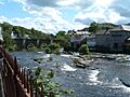
River Dee at Llangollen
|
|
| Native name | Afon Dyfrdwy |
| Country | Wales, England |
| Cities | Chester |
| Physical characteristics | |
| Main source | slopes of Dduallt above Llanuwchllyn, Snowdonia, Wales 450 m (1,480 ft) 52°49′56″N 3°45′56″W / 52.8322°N 3.7656°W |
| River mouth | Dee Estuary 0 m (0 ft) 53°21′14″N 3°13′33″W / 53.3539°N 3.2258°W |
| Length | 113 km (70 mi) |
| Discharge (location 2) |
|
| Discharge (location 3) |
|
| Basin features | |
| Basin size | 1,816.8 km2 (701.5 sq mi) |
| Tributaries |
|
The River Dee (called Afon Dyfrdwy in Welsh) is a famous river in the United Kingdom. It flows through parts of both Wales and England. For some of its journey, it even forms part of the border between these two countries.
The river starts high up in Snowdonia, Wales. It then flows east, passing through the city of Chester in England. Finally, it empties into the sea through an estuary located between Wales and the Wirral Peninsula in England. The River Dee is about 113 km (70 miles) long in total.
Contents
River Dee History
The River Dee has a long and interesting past. For many centuries, it was an important border for the ancient Welsh kingdom of Gwynedd. This might have been true since the kingdom began in the 400s.
In the 1200s, people wrote about the river as flumen Dubr Duiu. Its name likely comes from an old language called Brythonic. In this language, dēvā means "River of the Goddess" or "Holy River." Some people even thought of the river as a goddess of war and fate named Aerfen. The river's name also inspired the Roman fortress called Deva Victrix.
River Dee Facts and Figures
The area of land that drains into the River Dee is called its catchment area. This area, down to Chester Weir, covers about 1,816.8 km2 (701.5 sq mi). The average amount of rain that falls over this area each year is about 640 mm (25 in). This rain helps the river flow at an average of 37 cubic metres per second.
There are several large reservoirs in the River Dee's catchment area. These reservoirs help store water for different uses.
- Bala Lake (Llyn Tegid in Welsh): 400 acres (1.6 km2)
- Llyn Brenig: 370 acres (1.5 km2)
- Llyn Celyn: 325 acres (1.32 km2)
River Dee's Journey
Where the River Starts


The River Dee begins its journey high up on the slopes of Dduallt. This mountain is above Llanuwchllyn in the Snowdonia mountains of Gwynedd, Wales. Between its source and Bala Lake, the river is known by its Welsh name, Afon Dyfrdwy.
There's a legend that the river's water flows through Bala Lake without mixing with the lake water. When the river leaves Bala, it joins with the Afon Tryweryn. It then passes through the Bala sluice gates. These gates are part of the Dee Regulation Scheme, which helps protect towns downstream from big floods.
The river flows past villages like Llanfor and Llandderfel. It goes under the old Pont Fawr bridge, which is a Grade II listed structure. The Dee generally flows southeast through the Vale of Edeyrnion. The B4401 road follows the river from Bala to Cynwyd.
Leaving Gwynedd, the river enters Denbighshire. It flows under more historic bridges at Llandrillo and Cynwyd. Then it reaches the town of Corwen. From here, the river passes the Iron Age hillfort of Caer Drewyn. It then enters the beautiful Clwydian Range and Dee Valley AONB.
Through its forested valley, the river flows through Carrog, Glyndyfrdwy, and Llantysilio. The Llangollen Railway follows the river on its route between Llangollen and Corwen.
Famous Bridges and Landmarks
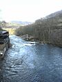
At Berwyn, the river flows over the man-made Horseshoe Falls. It then speeds up as it goes downhill past the Chain Bridge Hotel. The historic pedestrian Chain Bridge was first built in 1814. It was rebuilt in 1929 after a flood destroyed the original.
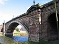
The river then flows through Llangollen and under its 16th-century bridge. This bridge is a Grade I listed structure and a Scheduled Ancient Monument. It is considered one of the Seven Wonders of Wales.
After Llangollen, the river continues east. It passes the limestone cliffs of Eglwyseg Rocks. Overlooking the river here is the ruined medieval fortress of Castell Dinas Brân.
The river then enters Wrexham County Borough. It passes south of Trevor and goes under Thomas Telford's Pontcysyllte Aqueduct. This aqueduct, built in 1805, carries the Llangollen Canal 120 feet (37 m) above the river.
Less than a mile east, at Cefn Mawr, the river is crossed by the Cefn Mawr Viaduct. This viaduct was built in 1848 by Thomas Brassey. It carries the Shrewsbury to Chester railway line over the Dee.
Beyond this point, the river forms the border between Wrexham County Borough in Wales and Shropshire in England. It passes Chirk and joins with the River Ceiriog. The river then starts to curve gently across the flat Cheshire Plain.
The river continues past Erbistock on the Welsh side. It also passes the 5th-century earthwork of Wat's Dyke on the English side. Then it flows entirely into Wales at Overton bridge. A few miles downstream is Bangor-on-Dee, known for its Racecourse.
The Dee continues to curve past Worthenbury. Here, it is joined by the River Clywedog. At this point, the border between Wrexham and Cheshire West and Chester follows the river. It passes the Cheshire village of Crewe by Farndon. Then it flows between Holt in Wales and Farndon in England. Here, it goes under the 14th-century, Grade I listed Farndon Bridge.
One of the main rivers that flows into the Dee is the River Alyn (Afon Alun in Welsh). This river flows through the Loggerheads area before joining the Dee north of Holt. The Alyn has many swallow holes and caves. In summer, parts of its riverbed can even dry up.
When the main River Dee gets close to the Cheshire border, it turns sharply north. It then winds its way up to Chester. This long part of the river only drops a few feet in height. The rich farmland next to it has many old coal workings and deep claypits. These pits were used to make bricks and tiles. Some of these pits are now used for landfill.
Near Churton and Aldford, the river flows entirely into England. It passes the grand Eaton Hall, which is the home of the Duke of Westminster. It then goes past the village of Eccleston and under the A55 North Wales Expressway. It flows north past the Roman Eaton Road to the Chester suburbs of Huntington and Handbridge. Finally, it reaches the centre of Chester.
In the city centre, the river flows around the Earl's Eye(s) meadow at Queen's Park. This area by the river is a popular place for fun. It has a bandstand, benches, and boat trips. Four bridges cross the river here.
The first is the Queen's Park Suspension Bridge. This bridge is only for people walking across the river in Chester. The second is the Old Dee Bridge, a road bridge and the oldest bridge in Chester. It was built around 1387 on the site of older wooden bridges from Roman times.


Above the Old Dee Bridge is Chester Weir. This weir was built by Hugh Lupus to provide power for his corn mills. Over the centuries, the weir has powered many types of mills. It was also used for a hydroelectric scheme in 1911. The building for this is still there today.
On this weir, there is a fish pass. This helps salmon swim upstream. There is also a weir gate for boats to go over the weir during high tides. A little further downstream is the Grosvenor Bridge. It was opened in 1833 to help with traffic on the Old Dee Bridge. Princess Victoria, who later became Queen, opened this bridge.
On the other side of the Grosvenor Bridge is the Roodee, which is Chester's racecourse. It is the oldest racecourse in the country. This area used to be Chester's Roman harbour. But over time, the River Dee filled up with mud, helped by the building of the weir. The only reminder of its past as a harbour is a stone cross in the middle of the Roodee. It has marks that look like water ripples.
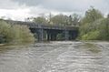
At the end of the Roodee, Chester's fourth bridge crosses the river. This bridge carries the North Wales Coast railway line. This bridge was also the site of a serious railway accident, known as the Dee bridge disaster.

The Man-Made River Section
West of Chester, the River Dee flows along a channel that people dug between 1732 and 1736. Engineers from the Netherlands planned and built this channel. Local businesses and the city of Chester paid for it. They wanted to make it easier for ships to travel and to stop the river from filling up with mud. Chester's trade had been getting worse because large ships could not reach the city anymore.
After four years of work, the river was moved from its natural winding path. The new, straight channel followed the coast of northeast Wales. During this time, new land was created from the estuary at Sealand and Shotton. Land was reclaimed in this area until 1916. You can still see where the river's natural path was by following the old banks along the western edge of the Wirral Peninsula.
This man-made channel is about 8 km (5 miles) long and goes into Wales and Flintshire at Saltney. On the west side, you can see Hawarden Airport and the large Airbus factory at Broughton. This area is called Deeside and has several big industries.
From here, the Dee flows under three road bridges. The first two are close together at Queensferry. One is a modern bridge from the 1960s that carries the A494 road. The other is the Jubilee Bridge, which is a special bridge that can roll open. It was finished in 1926. The newest bridge is at Connah's Quay. The Flintshire Bridge is a cable-stayed bridge that opened in 1999.
Between the second and third road bridges is the Hawarden railway bridge at Shotton. It was built as a swing bridge but is not opened anymore. It carries the Borderlands Line railway over the river. Hawarden Bridge station serves the nearby industrial park and power station.
A footbridge replaced the old passenger ferry at Saltney in the 1970s.
The Dee Estuary
Beyond Connah's Quay, the river widens into the Dee Estuary. This forms the northeastern part of the North Wales coast and the western coast of the Wirral. Towns along the coast include Flint and Holywell in Wales. On the Wirral side, there are towns like Neston and Parkgate.
The estuary is very important for birds. It is protected as a SSSI and a Ramsar site. This is because of the huge areas of mud that appear at low tide. There are also large saltmarshes on both sides, especially on the right bank north and south of Neston.
The estuary was formed by glaciers during past ice ages. These glaciers carved out a wide channel. The channel continues inland south of Chester, but its upper parts have filled in with sand, gravel, and mud. The process of filling in with mud continues today. The saltmarsh has grown quickly in the last century, pushing the high tide line further out into the estuary.
How People Use the River Dee


Industry and Water Use
Much of the land around the river is used for farming. Some water is taken from the river for irrigation in the summer. From Chirk downstream, the river valley has supported many industries. These industries were first attracted by coal mines and later by the deep clay deposits used to make bricks and tiles.
Industries in the valley today include making chemicals, wood products, cocoa milling, and fibreglass. Old clay pits are also used for waste disposal. These industries need a lot of clean water from the river.
Currently, the wings for the Airbus A380 are made at the Airbus factory in Broughton. They are too big to be shipped by plane, so they are taken downriver by barge to the Port of Mostyn.
There are many places where water is taken from the river upstream of Chester. Water companies and the canal take large amounts of water. The river's flow is carefully controlled using reservoirs. These reservoirs store water in winter and release it in summer. This whole system is managed by the Dee Regulation Scheme.
Downstream of Chester, water is also taken for cooling at the gas-fired power station at Connah's Quay. Water is also used by the paper mill and power station at Shotton.
Water Sports and Recreation
The Dee used to be a very popular river for whitewater kayaking and touring. It was especially known for a challenging section upstream of Llangollen. The river stays high after rain for longer than most British rivers. People can paddle on it all year round thanks to the Dee Regulation Scheme.
Canoeing was allowed on certain weekends each year. Thousands of canoeists would come to Llangollen for fun paddling, slalom competitions, and wild water races.
Today, canoeing is allowed on one 100-meter long rapid, about 1 km upstream of Llangollen. Wildwater and slalom races are still held at Serpent's Tail rapid. Canoeing and kayaking are also allowed between Farndon and Chester. This part of the river is affected by tides, so it is managed by the local council.
Every July, the Chester Raft Race is held on the Dee to raise money for charity. The Deva (Chester) Triathlon uses the Dee for the swimming part of the race.
There are several rowing clubs on the Dee in Chester. These include the Royal Chester Rowing Club and the Grosvenor Rowing Club. School rowing clubs like King's School Rowing Club also use the river. All these clubs share the slightly winding part of the river above the weir in Chester.
Fishing on the Dee


The River Dee has been famous for its fishing. People catch salmon and trout mostly in the upper parts of the river. The lower parts are good for catching other types of fish. In the late 1990s, a big pollution event in the middle of the river caused a lot of damage to the fish. However, the river's fish population has mostly recovered since then.
Images for kids
-
River Dee at Llangollen
-
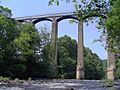
Pontcysyllte Aqueduct carrying the Llangollen Canal over the River Dee.
-
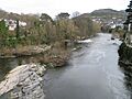
View downriver from the bridge in the centre of Llangollen (March 2007)
-

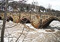
River Dee in snow at Llangollen (February 2007)
-
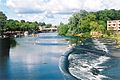
Chester Weir, Handbridge, Chester,(2002)
-
View of the Grosvenor Bridge, taken from the south bank of the river
-
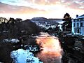
Winter sunrise at Llangollen
-
The bridge that carries the Chester and Holyhead Railway between Curzon Park and the Roodee at Chester.
-
The Chainbridge at Berwyn about three miles (5 km) upstream from Llangollen
-
The River Dee at Llangollen, after stormy weather
-
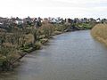
View of the Dee from the famous Grosvenor Bridge in Chester, looking downriver towards Curzon Park. Taken in spring at high tide
-
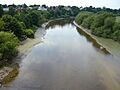
Same view of the Dee in Chester, looking downriver towards Curzon Park. Taken in summer at low tide.
See also
 In Spanish: Río Dee (Gales e Inglaterra) para niños
