
Acton, Massachusetts facts for kids
Quick facts for kids
Acton, Massachusetts
|
||
|---|---|---|

Acton Town Hall
|
||
|
||

Location in Middlesex County, Massachusetts
|
||

Acton, Massachusetts
Location in Massachusetts

Acton, Massachusetts
Location in the United States

Acton, Massachusetts
Location in North America
|
||
| Country | United States | |
| State | Massachusetts | |
| County | Middlesex | |
| Settled | 1639 | |
| Incorporated | 1735 | |
| Government | ||
| • Type | Open town meeting | |
| Area | ||
| • Total | 20.3 sq mi (52.5 km2) | |
| • Land | 20.0 sq mi (51.7 km2) | |
| • Water | 0.3 sq mi (0.8 km2) | |
| Elevation | 260 ft (79 m) | |
| Population
(2020)
|
||
| • Total | 24,021 | |
| • Density | 1,201.1/sq mi (464.6/km2) | |
| Time zone | UTC−5 (Eastern) | |
| • Summer (DST) | UTC−4 (Eastern) | |
| Area codes | 978, 351 | |
| FIPS code | 25-00380 | |
| GNIS feature ID | 0618213 | |
| Website | www.actonma.gov | |

Acton is a town in Middlesex County, Massachusetts, United States. It is about 21 miles (34 km) northwest of Boston. Acton is west of Concord and southwest of Lowell. In April 2020, about 24,021 people lived here.
Acton became an official town in 1735. It uses an Open Town Meeting style of government. This means citizens can vote directly on town matters. The town also has a town manager and five elected board members.
Acton has been named one of the "Best Places To Live" among small towns. Money Magazine ranked it 11th in 2015. The local high school, Acton-Boxborough Regional High School, was recognized as a top school in 2009.
Contents
- Exploring Acton's Geography
- Acton's Population and People
- Acton's Rich History
- Fun Outdoor Places in Acton
- Learning in Acton: Schools and Education
- Acton's Cultural Spots
- Interesting Places to Visit
- Getting Around Acton: Transportation
- Acton's Radio Stations
- Famous People from Acton
- Images for kids
- See also
Exploring Acton's Geography

Acton is located at 42°29′N 71°27′W. The town covers about 20.3 square miles (52.5 km2). Most of this area is land, with only 0.3 square miles (0.8 km2) being water. Much of Acton is covered by forests. Some areas are used for homes or farms.
Acton's landscape was shaped by glaciers about ten thousand years ago. The town has nine drumlins, which are hills made of glacial material. There are also two kettle ponds, Wills Hole and Grassy Pond. These ponds formed in hollows left by large ice blocks.
Acton has two main stream systems. The Nashoba Brook system includes Butter Brook, Wills Hole Brook, and Conant Brook. The Fort Pond Brook system includes Guggins Brook, Inch Brook, Grassy Pond Brook, Pratt's Brook, and Coles Brook. Both systems flow into the Assabet River. Nagog Pond is in the north and provides drinking water to Concord. There is also a small artificial pond at NARA Park.
Acton's Five Village Centers
Acton has five main village centers. Acton Center is the town's main civic area. The other four centers got their names from old railroad stations.
Acton Center: The Heart of the Town
Acton Center is where you'll find the town hall and the main public library. There's also a playground and a monument. This monument remembers Acton residents who died in the "Concord Fight" during the Revolutionary War. You can also find a fire station and the Acton Congregational Church here. An arboretum (a tree garden) and conservation area cover 64 acres (26 ha).
West Acton: A Busy Commercial Area
West Acton is an important shopping area. It has many businesses along Route 111. This area grew because of the Fitchburg Railroad in the 1800s.
South Acton: A Place of History
.jpg)
South Acton used to be the most industrial part of town. In the 1700s, many mills here used water power from Fort Pond Brook. The Faulkner House is the oldest home still standing in Acton, built in 1707. The Faulkner family owned mills across the street. Jones Tavern is another old building from the Revolutionary War era. It is listed on the National Register of Historic Places. The South Acton (MBTA station) is the only train station still active in Acton.
East Acton: A Quiet Residential Spot
East Acton was once a small commercial area around its train station. When cars became popular and the train line closed, it became mostly residential. Now, businesses are mainly along the Route 2A corridor.
North Acton: Modern Growth and Recreation
North Acton has grown a lot since the late 1970s. Many businesses and condominium buildings have been built along the Route 2A/119 area. The Nathaniel Allen Recreation Area, also called NARA Park, is here. It has a swimming pond, an outdoor stage, playing fields, and walking trails. North Acton also includes the Village of Nagog Woods, which has its own ZIP code.
The town plans to focus new building in these village centers. This helps to prevent too much sprawl and keeps open spaces safe.
Acton's Population and People
| Historical population | ||
|---|---|---|
| Year | Pop. | ±% |
| 1850 | 1,685 | — |
| 1860 | 1,726 | +2.4% |
| 1870 | 1,593 | −7.7% |
| 1880 | 1,797 | +12.8% |
| 1890 | 1,897 | +5.6% |
| 1900 | 2,120 | +11.8% |
| 1910 | 2,136 | +0.8% |
| 1920 | 2,162 | +1.2% |
| 1930 | 2,482 | +14.8% |
| 1940 | 2,701 | +8.8% |
| 1950 | 3,510 | +30.0% |
| 1960 | 7,238 | +106.2% |
| 1970 | 14,770 | +104.1% |
| 1980 | 17,544 | +18.8% |
| 1990 | 17,872 | +1.9% |
| 2000 | 20,331 | +13.8% |
| 2010 | 21,924 | +7.8% |
| 2020 | 24,021 | +9.6% |
| 2022* | 23,829 | −0.8% |
| * = population estimate. Source: United States Census records and Population Estimates Program data. |
||
In 2020, Acton had 24,021 residents. This was a 9.6% increase from 2010. There were 8,931 households.
About 42.7% of households had children under 18 in 2010. Most households (63.5%) were married couples living together. About 23.0% of households had people aged 65 or older living alone.
The median age in Acton was 38 years old. For every 100 females, there were about 97 males. Most adults (97.2%) had a high school degree or higher. Many (72.0%) had a bachelor's degree or more.
The median household income in 2020 was $138,163. About 3.3% of the population lived below the poverty line.
Acton has a growing Chinese American population. In 2010, there were 2,041 Chinese Americans, a big increase from 2000. In 2014, about 25% of Acton residents were born outside the United States.
Acton's Rich History
Acton's history shows the story of Massachusetts and the United States. Native Americans first settled here. They used the Assabet, Sudbury, and Concord rivers for travel. They also farmed the land. There is proof of Native American settlements in Acton from 7,000 years ago. When European colonists arrived, many Native Americans died from diseases they had no immunity to.
From Colonists to Revolutionaries

Concord was the first inland colonial town in Massachusetts. Acton was originally part of Concord. Colonists used Acton's land for grazing their animals. The first home in what is now Acton was built in 1639.
Acton became its own town on July 3, 1735. Since then, Acton has held yearly town meetings. Records of these meetings are kept at Acton's Memorial Library.
Acton residents showed their anger towards Great Britain. On October 3, 1774, they sent a list of complaints to King George III. This day is now called Crown Resistance Day in Acton.
The Revolutionary War began on April 19, 1775. Acton's minutemen joined the fight. They marched to the North Bridge in Concord. This was part of the Battle of Lexington and Concord. Captain Isaac Davis led the Acton minutemen. When a group was needed to lead the attack on the bridge, Captain Davis said, "I haven't a man who is afraid to go." It is believed Acton's men led because they had bayonets.
During the fight, Captain Isaac Davis and Private Abner Hosmer from Acton were killed. Davis was the first officer to die in the American Revolutionary War. People in the area said it was "the battle of Lexington, fought in Concord, by men of Acton."
Growth and the Civil War Era
In the 1800s, Acton became part of the Industrial Revolution. By the mid-1800s, Acton was a center for making barrels. There were also mills for making powder, grinding grain, and sawing wood. The American Powder Mills made gunpowder from 1835 to 1940.
The railroad came to Acton on October 1, 1844. The Fitchburg Railroad went through South and West Acton to serve the mills. South Acton became a busy rail hub. Two other railroads also crossed the town.
By 1874, Acton's population was almost 1,700. The town started its first newspaper, The Acton Patriot. West Acton residents started the first library, The Citizen's Library. In 1890, the Memorial Library was built. William A. Wilde gave it to the town to honor Acton soldiers who fought in the Civil War.
Fun Outdoor Places in Acton
Acton has over 1,650 acres (6.7 km2) of town-owned conservation lands. These are great places to explore nature!
Beautiful Conservation Lands
- Acton Arboretum: This park in the center of Acton has 53 acres (21 ha) of woods, meadows, and ponds. It became an arboretum in 1986. It has different gardens, like an herb garden and a butterfly garden.
- Pratt's Brook: A 57-acre (23 ha) property in South Acton.
- Great Hill: This 185-acre (0.75 km2) property in South Acton has picnic tables. There's also a skating pond and playing fields.
- Grassy Pond and Nagog Hill: These two areas in North Acton cover 250 acres (1.0 km2).
- Wills Hole Conservation Area and Town Forest: A 73-acre (30 ha) property in North Acton. It has a bog and is next to an old granite quarry.
- Nashoba Brook, Spring Hill, Camp Acton, Canterbury Hill: These four areas in North Acton cover over 600 acres (2.4 km2). Their trails are part of the Bay Circuit Trail and Greenway. This is a long hiking path that goes around Boston. A historical trail called the Trail Through Time also runs here. It has signs about places like the Potato Cave and The Pencil Factory.
- Bulette Land/Town Forest: This 48-acre (19 ha) area has wetlands and forests.
- Heath Hen Meadow: This land covers 99 acres (40 ha).
- Jenks Land: This 30-acre (12 ha) area is home to over 170 kinds of birds.
- Morrison Farm & Ice House Pond: Located off Concord Rd, this 70-acre (28 ha) property includes a house, stable, fields, and water.
Fields and Playgrounds for Sports
- Leary Field: This turf field and track is used for Acton-Boxborough Regional High School sports.
- High School Complex: Has grass fields, two lighted turf fields, tennis courts, and baseball diamonds.
- Elm Street Complex: Includes tennis courts and lighted softball diamonds.
- Gates Fields: Two softball diamonds at the Gates School.
- Nathaniel Allen Recreation Area (NARA): This park was renamed to honor Nathaniel M. Allen, a Civil War hero from Acton. It has a softball diamond, a large field, a swimming pond, and a playground. It's also where the town's Fourth of July fireworks happen.
- Veterans Field: Has two baseball diamonds and a playground.
- MacPherson & Hart Fields: Baseball diamonds at Conant School.
- TJ O'Grady Skate Park: A place for skateboarding and rollerblading.
- Jones Field: Has a baseball diamond and a playground.
- Great Hill: A large field and playground at the front of the conservation area.
- School Street Fields: A large grass area for multiple sports.
- Concord Road: Used mainly for soccer.
- Gardner Field: In West Acton, with a playground, basketball hoop, and field.
- Goward Playground: Located behind the Acton Memorial Library.
Bike Paths for Fun Rides
- Bruce Freeman Rail Trail: The Acton part of this trail opened in 2018. It goes north through Carlisle, Westford, Chelmsford, and Lowell. When finished, it will be 25 miles long.
- Assabet River Rail Trail: The Acton part of this trail starts at the South Acton Train Station. It goes 3.4 miles south through Maynard.
Learning in Acton: Schools and Education
Acton is part of the Acton Boxborough Regional School District (ABRSD) along with Boxborough.
Elementary Schools in Acton
The town has five elementary schools for students in kindergarten through sixth grade:
- CT Douglas School
- Gates School
- Luther Conant School
- McCarthy-Towne School
- Merriam School
The ABRSD uses a special "Open Enrollment" system for elementary schools. Parents choose their preferred school for kindergarten. This means students from different neighborhoods can go to school together. This helps students and families connect with people from all over town.
Each elementary school has a different way of teaching:
- Conant School: Named for Luther Conant, a long-time teacher and town leader.
- Douglas School: Named for Carolyn T. Douglas, a teacher and principal.
- Gates School: Named for Paul P. Gates, the school doctor.
- McCarthy-Towne School: Named for Julia McCarthy and Marion Towne, both teachers. This school shares a building with Merriam School. Students often call teachers by their first names.
- Merriam School: Named for Florence A. Merriam, a teacher for 35 years. Merriam uses a project-based learning style. Teachers often stay with the same group of students for two years. Students also call teachers by their first names.
Acton-Boxborough Junior High and High School
The Acton-Boxborough Regional School District has one junior high school and one high school.
- Raymond J. Grey Junior High School is for grades 7 and 8.
- Acton-Boxborough Regional High School is for grades 9 through 12.
Both schools were made bigger and updated between 2000 and 2005. They are located on the same campus in Acton. The junior high has about 1,000 students, and the high school has about 2,000 students. The high school is often ranked as one of the best public high schools in the Boston area.
Acton's Cultural Spots

Libraries for Reading and Learning
Acton has two public libraries:
- Acton Memorial Library: Given to the town in 1890 to honor Civil War veterans. It has been expanded twice.
- West Acton Citizens' Library: The first library in town, started in 1874.
Each school also has its own library. The Acton Historical Society has the Jenks Library, with old maps, documents, and photos.
Museums to Explore History and Science
- Discovery Museum: A hands-on museum for families to learn and play.
- Iron Work Farm: This group runs two historic houses: Jones Tavern and Faulkner House. They are open to the public on certain days.
- Hosmer House: This house from the Revolutionary War era is open on special days, like Patriots' Day.
Theater for Fun and Shows
Acton has several theater groups.
- Theatre III: Started in 1956, it puts on plays and musicals in an old church building.
- Open Door Theater: This group creates plays where everyone can join, including people with special needs. They perform at the R. J. Grey Junior High School.
Town Traditions and Celebrations

- Patriots' Day: Every year on Patriots' Day (the third Monday in April), the Acton Minutemen lead a march. They walk from Acton Center to the Old North Bridge in Concord. This path is called 'The Isaac Davis Trail'. Boy Scouts also do an annual march along this trail.
- Fourth of July Fireworks: The town celebrates with fireworks at NARA Park.
Interesting Places to Visit
- Jones Tavern: The main part of this old tavern was built in 1732. It was a house that became a tavern and general store. It might have been the first store in Acton.
- The Faulkner House and Mills: This house was built in 1702. It was part of an early textile business. It also served as a safe place during Indian raids and for the South Acton Militia during the Revolutionary War.
- Town Center: The town's civic center has the Acton Monument. This is where Captain Isaac Davis, James Hayward, and Abner Hosmer are buried. A stone nearby marks where Captain Davis fell.
Getting Around Acton: Transportation
Acton is about 5 miles (8 km) from I-495 and 10 miles (16 km) from I-95/Route 128. Several state routes, like Route 2 and Route 27, pass through town.
The MBTA Commuter Rail Fitchburg Line train stops at the South Acton station. This train connects Acton to cities like Fitchburg, Lowell, Concord, and Boston.
Yankee Lines offers a bus service to Copley Square in Boston from Acton.
The Bruce Freeman Rail Trail and the Assabet River Rail Trail are paved paths for bikes. They connect Acton to nearby towns.
Acton's Radio Stations
- WAEM-LP (94.9 MHz): This is a town-run low power community radio station. It plays a variety of music.
- WHAB (89.1 MHz): This is a high school radio station run by Acton-Boxborough Regional High School. It plays music chosen by students.
Famous People from Acton
Many interesting people have connections to Acton:
- Tom Barrasso: A professional hockey player in the NHL.
- Steve Carell: A well-known comedic actor.
- Isaac Davis: The captain of the Acton Minutemen, and the first officer to die in the American Revolution.
- Drew Houston: The founder of Dropbox, a popular online storage service.
- Shin Lim: A close-up magician who won America's Got Talent.
- Dr. John "Dropkick" Murphy: A wrestler who had a sanatorium in Acton. The band Dropkick Murphys is named after him.
- Caroll Spinney: The puppeteer who created Big Bird and Oscar the Grouch for Sesame Street.
- Madeline Amy Sweeney: A flight attendant who was a hero during the September 11 attacks.
- Taylor Jenkins Reid: A popular author of novels like Seven Husbands of Evelyn Hugo.
Images for kids
-
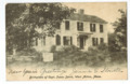
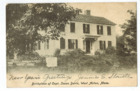
Isaac Davis' birth house in Acton, Massachusetts in 1905
-

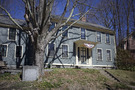
Isaac Davis' birth house in Acton, Massachusetts in 2015
See also
 In Spanish: Acton (Massachusetts) para niños
