Course of the Willamette River facts for kids
Quick facts for kids Willamette |
|
|---|---|
|
|
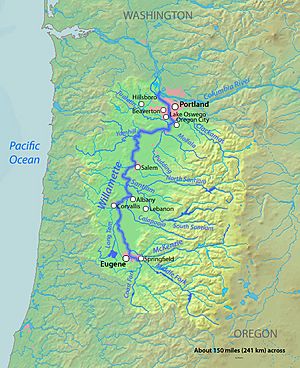
A map of the Willamette River, its drainage basin, major tributaries and major cities
|
|
|
Location of the mouth of the Willamette River in Oregon
|
|
| Country | United States |
| State | Oregon |
| Physical characteristics | |
| Main source | Confluence of Middle Fork Willamette River and Coast Fork Willamette River near Eugene, Lane County, Oregon 438 ft (134 m) 44°01′23″N 123°01′25″W / 44.02306°N 123.02361°W |
| River mouth | Columbia River Portland, Multnomah County, Oregon 10 ft (3.0 m) 45°39′10″N 122°45′53″W / 45.65278°N 122.76472°W |
| Length | 187 mi (301 km) |
| Basin features | |
| Basin size | 11,100 sq mi (29,000 km2) |
The Willamette River is a long river in the U.S. state of Oregon. It flows for about 187 miles (301 km) and is a major branch of the Columbia River. The Willamette River starts in the mountains south and southeast of the cities of Eugene and Springfield.
The river officially begins where the Middle Fork Willamette River and Coast Fork Willamette River meet near Springfield. From there, it mostly flows north. The river makes two big turns: one near Newberg, where it turns sharply east, and another turn back north about 18 miles (29 km) later. Near its end, the river splits into two paths around Sauvie Island. The main path joins the Columbia River, while a smaller path, the Multnomah Channel, joins the Columbia River further downstream.
Many cities are located along the Willamette River. These include Springfield, Eugene, Corvallis, Albany, Salem, Oregon City, and Portland. Important smaller rivers that flow into the Willamette include the McKenzie, Santiam, Yamhill, Tualatin, and Clackamas rivers.
The Willamette River starts at about 438 feet (134 m) above sea level. It drops about 428 feet (130 m) by the time it reaches its mouth. This means it drops about 2.3 feet for every mile it flows. At Willamette Falls, the river drops about 40 feet (12 m) in a big waterfall. After the falls, the river is very flat. The ocean's tides from the Columbia River can even affect this part of the Willamette. The main part of the river is usually between 330 to 660 feet (100 to 200 m) wide.
Contents
Where Does the Willamette River Start?
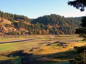
The Willamette River begins where two main branches, the Middle Fork and the Coast Fork, come together. The Middle Fork and its own branch, the North Fork, start in the Cascade Range mountains. The Middle Fork flows northwest through the mountains into the southern part of the Willamette Valley.
The Coast Fork starts in the Calapooya Mountains and the eastern slopes of the Oregon Coast Range. It flows north to meet the Middle Fork about 3 miles (4.8 km) southeast of Eugene. The spot where these two forks meet is the official start of the Willamette River, about 438 feet (134 m) above sea level.
Journey Through the Willamette Valley
The Willamette River's journey takes it through many towns and natural areas.
From Eugene to Albany
At its start, the river flows north for about 2 miles (3.2 km). It passes through Springfield and then turns west, entering Eugene. In Eugene, the river flows past parks like Alton Baker Park and Skinner Butte Park. It goes under several bridges, including ones for bikes and cars. After leaving Eugene, the river receives the McKenzie River from the right.
As it continues north, the Willamette River forms the border between Lane County and Linn County for a while. It then becomes the border between Linn County and Benton County. Along this stretch, the river flows around many islands and receives smaller rivers like the Long Tom River and Marys River.
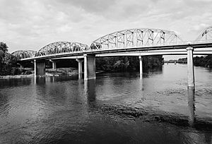
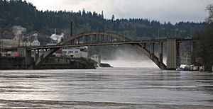
The river reaches Corvallis, where it flows past parks and under more bridges. After Corvallis, it receives the Dead River and the Little Willamette River. Finally, the Calapooia River joins the Willamette as it reaches Albany. In Albany, the river flows under the Ellsworth Street Bridge and the Lyon Street Bridge.
From Albany to Oregon City
In Albany, the river flows east through the city before turning north. It passes by several lakes and industrial areas. The Willamette then becomes the border between Linn County and Polk County, and later between Polk County and Marion County.
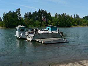
The Santiam River and Luckiamute River both join the Willamette in this area. The river passes Buena Vista, where the Buena Vista Ferry carries cars across the river. Further downstream, the river flows past Ankeny National Wildlife Refuge and the city of Independence.
The river then reaches Salem, the capital city of Oregon. In Salem, it flows under the Center Street Bridge and the Marion Street Bridge. It also receives Mill Creek. North of Salem, the river passes Keizer.
The Willamette then forms the border between Marion County and Yamhill County. Here, Willamette Mission State Park is on the right, and the Wheatland Ferry crosses the river. The Yamhill River joins the Willamette from the left.
The river then reaches Newberg, where it makes a sharp turn to the east. It flows past Champoeg State Park, an important historical site. The river then enters Clackamas County.
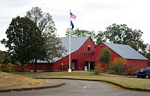
Near Wilsonville, the river flows under the Boone Bridge, which carries Interstate 5. The Molalla River joins the Willamette here. The Canby Ferry also crosses the river in this area. The river then turns sharply north again.
As it gets closer to Oregon City, the Willamette flows through the Rock Island Complex. The Tualatin River joins the Willamette from the left near West Linn. Finally, the river approaches Willamette Falls.
From Oregon City to the Columbia River
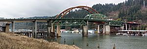
At Willamette Falls, the river drops about 40 feet (12 m) between West Linn and Oregon City. Below the falls, the river flows under the Oregon City Bridge and the Abernethy Bridge. The Clackamas River joins the Willamette from the right.
The river then flows past Mary S. Young State Recreation Area and Lake Oswego, where Oswego Creek enters. The Willamette continues north, passing Milwaukie, and receiving Kellogg Creek and Johnson Creek.

As the river enters Portland, it flows past Sellwood Riverfront Park and Oaks Amusement Park. It goes around several islands, including Ross Island. In downtown Portland, the Willamette flows under many famous bridges, such as the Ross Island Bridge, Hawthorne Bridge, Morrison Bridge, Burnside Bridge, Steel Bridge, and Broadway Bridge. It also passes Tom McCall Waterfront Park.
Further downstream, the river flows under the Fremont Bridge. It passes Swan Island and the University of Portland. The river then flows under the Burlington Northern Railroad Bridge 5.1 and the St. Johns Bridge.
About 3.5 miles (5.6 km) from its mouth, the river splits around Sauvie Island. The main channel flows north past the island and industrial areas. The Columbia Slough enters from the right. Finally, the Willamette River joins the Columbia River at Kelley Point Park, about 101 miles (163 km) from the Columbia's mouth on the Pacific Ocean. The Willamette's mouth is about 10 feet (3.0 m) above sea level.
Multnomah Channel: An Extra Path
The Multnomah Channel is a smaller branch of the Willamette River. It flows northwest and then north around Sauvie Island for about 21.5 miles (34.6 km). This channel eventually meets the Columbia River near St. Helens.
Along its path, the Multnomah Channel receives several small creeks like Miller Creek, Ennis Creek, and McCarthy Creek. It also flows around Coon Island and Louse Island. The channel merges with Scappoose Bay before joining the Columbia River.
How Much Water Flows?
The Willamette River is very important because it provides a lot of water to the Columbia River. It ranks as the 19th largest river in the U.S. by water volume. The Willamette contributes about 12 to 15 percent of the Columbia River's total flow.
On average, about 32,400 cubic feet per second (920 m3/s) of water flows out of the Willamette River's mouth. This amount changes a lot throughout the year. In the dry season (August), it might be around 8,200 cubic feet per second (230 m3/s). In December, it can be over 79,000 cubic feet per second (2,200 m3/s).
The United States Geological Survey (USGS) has special stations called stream gauges along the river. These gauges measure how much water is flowing. There are gauges at Harrisburg, Albany, Salem, and Portland. The one at Albany has been collecting data since the 1880s.
The flow of the river is controlled by many dams on its smaller branches. Water is also taken out for farming, city use, and making electricity. The Willamette River has experienced very large floods in the past. The biggest recorded flood happened in 1861.
Images for kids
 | William Lucy |
 | Charles Hayes |
 | Cleveland Robinson |


