
The Gambia facts for kids
Quick facts for kids
Republic of The Gambia
|
|
|---|---|
 Coat of arms
|
|
|
Motto: "Progress, Peace, and Prosperity"
|
|
|
Anthem: "For The Gambia Our Homeland"
|
|
.svg)
Location of The Gambia (dark green) in western Africa
|
|
| Capital | Banjul 13°27′00″N 16°34′30″W / 13.45000°N 16.57500°W |
| Largest metropolitan area | Serekunda |
| Official languages | English |
| National languages | |
| Ethnic groups
(2013 Census)
|
|
| Religion
(2023)
|
|
| Demonym(s) | Gambian |
| Government | Unitary presidential republic |
| Adama Barrow | |
| Muhammad B.S. Jallow | |
|
• Speaker of the National Assembly
|
Fabakary Tombong Jatta |
| Legislature | National Assembly |
| Independence from the United Kingdom | |
|
• from the United Kingdom
|
18 February 1965 |
|
• dissolution of the Senegambia Confederation
|
30 September 1989 |
| Area | |
|
• Total
|
11,300 km2 (4,400 sq mi) (159th) |
|
• Water (%)
|
11.5 |
| Population | |
|
• 2023 estimate
|
2,468,569 (144th) |
|
• Density
|
176.1/km2 (456.1/sq mi) (74th) |
| GDP (PPP) | 2023 estimate |
|
• Total
|
|
|
• Per capita
|
|
| GDP (nominal) | 2023 estimate |
|
• Total
|
|
|
• Per capita
|
|
| Gini (2015) | ▼ 35.9 medium |
| HDI (2022) | low · 174th |
| Currency | Gambian dalasi (GMD) |
| Time zone | UTC (GMT) |
| Daylight saving time is not observed | |
| Driving side | right |
| Calling code | +220 |
| ISO 3166 code | GM |
| Internet TLD | .gm |

The Gambia, officially known as the Republic of The Gambia, is a country in West Africa. It is the smallest country on the African mainland. The Gambia is surrounded by Senegal on all sides. Its western side has a border with the Atlantic Ocean.
The country is shaped by the Gambia River, which flows through its center. This river empties into the Atlantic Ocean. The Gambia covers an area of about 11,300 square kilometers (4,007 sq mi). In 2024, its population was around 2.7 million people.
The capital city is Banjul. It is the largest metropolitan area in the country. Other big cities include Serekunda and Brikama.
Arab Muslim traders first came to The Gambia in the 9th and 10th centuries. In 1455, the Portuguese were the first Europeans to arrive. The British Empire started a colony there in 1765. The Gambia gained independence in 1965, led by Dawda Jawara. Later, Yahya Jammeh took power in 1994.
Adama Barrow became The Gambia's third president in January 2017. He won the December 2016 elections against Yahya Jammeh. Jammeh first accepted the results, but then refused to leave office. This caused a big political problem. The Economic Community of West African States (ECOWAS) sent military help. Jammeh left office two days after his term was supposed to end.
The Gambia's economy mainly relies on farming, fishing, and tourism. In 2022, about 17.2% of people lived in extreme poverty. This means they lived on less than US$2.15 per day. The Gambia is a founding member of ECOWAS. It rejoined the Commonwealth of Nations in 2018. The country had left the Commonwealth in 2013. English is the only official language. It became widely used during British rule.
Contents
- Understanding the Name of The Gambia
- A Look at The Gambia's Past
- Exploring The Gambia's Geography
- Government and Political System
- The Gambian Economy
- Getting Around: Transportation
- The People of The Gambia: Demographics
- The Culture of The Gambia
- Images for kids
- See also
Understanding the Name of The Gambia
The name "Gambia" comes from the Mandinka words Kambra or Kambaa. These words mean the Gambia River. Some people think it might come from the Serer word Gamba. This is a special calabash drum played when a Serer elder passes away.
When The Gambia became independent in 1965, it was called The Gambia. In 1970, it became a republic. Its full name then became Republic of The Gambia.
In December 2015, Yahya Jammeh changed the name to Islamic Republic of The Gambia. But on January 29, 2017, President Adama Barrow changed it back. It is now again Republic of The Gambia.
The Gambia is one of the few countries that uses "the" in its official name. This is because the region was named after "The Gambia [River]". In 1964, before independence, Prime Minister Dawda Jawara asked to keep "the". This helped avoid confusion with Zambia, which also became independent around that time.
A Look at The Gambia's Past
Early Influences: Muslims and Portuguese (9th–16th Centuries)
Arab traders wrote the first records about The Gambia. This was in the ninth and tenth centuries. During the tenth century, Muslim traders and scholars set up communities. They created trade routes across the Sahara Desert. They traded local people who were captured and sold as slaves. They also exported gold and ivory. Manufactured goods were brought in through these routes.

By the 11th or 12th century, rulers of kingdoms like Takrur had become Muslim. They hired Muslims who could read and write Arabic. In the early 14th century, most of The Gambia was part of the Mali Empire. The Portuguese arrived by sea in the mid-15th century. They started to control trade from overseas.
British and French Rule in The Gambia
In 1588, the Portuguese claimant to the throne sold trade rights on the Gambia River to English merchants. Queen Elizabeth I confirmed this right. In 1618, King James I of England gave a charter to an English company. This allowed them to trade with The Gambia and the Gold Coast.
Between 1651 and 1661, parts of The Gambia were ruled by the Duchy of Courland and Semigallia. This included St. Andrew's Island and St. Mary Island (now Banjul). These areas were formally given to England in 1664.
In the late 1600s and 1700s, the British Empire and the French Empire often fought. They wanted control over trade in the Senegal and Gambia River regions. The British took control of The Gambia in 1758. The 1783 Treaty of Versailles gave Great Britain the Gambia River. However, France kept a small area called Albreda. This was finally given to the United Kingdom in 1856.
The Era of Slavery (17th–19th Centuries)
About three million people were taken as slaves from this region. This happened during the three centuries of the transatlantic slave trade. Many were sold by other Africans to Europeans. Some were prisoners from wars between tribes. Others were sold because of debts or were kidnapped.

At first, people were sent to Europe to work as servants. Later, the demand for workers grew in the West Indies and North America. In 1807, the United Kingdom stopped the slave trade across its empire. They also tried to stop the slave trade in The Gambia. Slave ships caught by the Royal Navy were sent back to The Gambia. The freed people were released on MacCarthy Island. The British set up a military post in Bathurst (now Banjul) in 1816.
Becoming a British Colony (1821–1965)
Over the years, Bathurst (now Banjul) was sometimes managed by the British Governor-General in Sierra Leone. In 1888, The Gambia became its own separate colony.

Britain and France agreed on the colony's borders in 1889. Local leaders resisted this division of their lands. The Gambia became a British Crown colony called British Gambia. It was split into the colony (Banjul area) and the protectorate (the rest of the land). The Gambia slowly moved towards self-governance. Slavery was officially ended in 1906. British rule became strong after a short conflict.
During World War II, some Gambian soldiers fought with the Allies of World War II. Many fought in Burma. A cemetery for war graves is in Fajara, near Banjul. Banjul had an airstrip for the US Army Air Forces. It was also a port for Allied ships.
After World War II, The Gambia gained more self-rule. In 1962, general elections were held. The United Kingdom granted full internal self-governance the next year.

Independence and Modern Times (1965–Present)
From Monarchy to Republic
The Gambia became independent on February 18, 1965. It was a constitutional monarchy within the Commonwealth. Queen Elizabeth II was the Queen of The Gambia. The country then held a vote to become a republic. This vote did not get enough support to change the constitution. However, it showed that The Gambia had fair elections and civil rights.
On April 24, 1970, The Gambia became a Republic within the Commonwealth. Prime Minister Sir Dawda Kairaba Jawara became the first President. He was both the head of state and head of government. He was re-elected five times.
The 1981 Attempted Coup
On July 29, 1981, there was an attempt to take over the government. This happened when President Jawara was in London. A group called the National Revolutionary Council tried to seize power.
President Jawara asked Senegal for military help. Senegal sent troops to The Gambia. By August 6, about 2,700 Senegalese troops had arrived. They defeated the rebels. Between 500 and 800 people died during this event.
The Senegambia Confederation
In 1982, Senegal and The Gambia signed a treaty. They formed the Senegambia Confederation. Their goal was to combine their armies and economies. The Gambia left this confederation in 1989.
Yahya Jammeh's Rule and Return to Democracy
In 1994, the Armed Forces Provisional Ruling Council (AFPRC) took over the government. They stopped political activities. Lieutenant Yahya Jammeh became the head of state. He was only 29 years old. The AFPRC promised to return to a democratic government.

In 1997, the was set up. It was in charge of elections. The IEC organized elections in 2001 and 2002. Foreign observers said these elections were fair. President Yahya Jammeh was re-elected. His party, the Alliance for Patriotic Reorientation and Construction (APRC), kept its majority.
Leaving the Commonwealth and a Name Change
On October 2, 2013, The Gambia announced it would leave the Commonwealth. This ended 48 years of membership. The government said it would not be part of any "Neo-Colonial institution."
On December 11, 2015, President Jammeh declared The Gambia an Islamic Republic. He said this was to break from its colonial past. However, the country's constitution remained secular.
The 2016 Presidential Elections
The time before the December 2016 election was tense. A youth leader from the main opposition party, Solo Sandeng, died while being held. Ousainou Darboe, the party leader, and others were jailed. This was for demanding Solo Sandeng's release.
President Jammeh faced Adama Barrow and Mamma Kandeh in the election. Ousainou Darboe was jailed, so Adama Barrow ran for his party.
Political Challenges
After the December 1, 2016 elections, Adama Barrow was declared the winner. Jammeh, who had ruled for 22 years, first agreed to step down. But then he said the results were not valid and asked for a new vote. This caused a constitutional crisis. An invasion by an ECOWAS group followed. On January 20, 2017, Jammeh announced he would step down and leave the country.
Barrow's First Term as President
In January 2017, President Barrow removed "Islamic" from The Gambia's name. On February 14, 2017, The Gambia started the process to rejoin the Commonwealth. It officially rejoined on February 8, 2018. Boris Johnson, a British official, welcomed The Gambia's return.
The 2021 Presidential Election
On December 4, 2021, Adama Barrow won re-election. On December 20, 2022, a supposed attempt to take over by the Gambian army was stopped. Four soldiers were arrested. The Armed Forces said no coup attempt was made. Barrow's use of foreign troops for his safety has made him less popular.
Exploring The Gambia's Geography

The Gambia is a very small and narrow country. Its borders follow the winding Gambia River. It lies between 13 and 14 degrees North latitude. It is also between 13 and 17 degrees West longitude.
The Gambia is less than 50 kilometers (31 miles) wide at its widest point. Its total area is about 11,295 square kilometers (4,361 sq mi). About 1,300 square kilometers (500 sq mi) of this area is water. It is the smallest country on the African mainland. The Gambia is slightly larger than the island of Jamaica.
Senegal surrounds The Gambia on three sides. The country has 80 kilometers (50 miles) of coastline on the Atlantic Ocean. This marks its western edge.
The current borders were set in 1889 by an agreement between the United Kingdom and France. It took almost 15 years to finalize the borders. The British gained control of areas about 10 kilometers (6.2 miles) north and south of the Gambia River.
The Gambia has three main natural areas: Guinean forest-savanna mosaic, West Sudanian savanna, and Guinean mangroves.
The Climate of The Gambia
The Gambia has a tropical savannah climate. This means it has a wet season and a dry season. The short rainy season usually lasts from June to September. From September to May, temperatures are lower and there is less precipitation. The climate is similar to that of neighboring Senegal, Mali, and northern Guinea.
| Climate data for Banjul | |||||||||||||
|---|---|---|---|---|---|---|---|---|---|---|---|---|---|
| Month | Jan | Feb | Mar | Apr | May | Jun | Jul | Aug | Sep | Oct | Nov | Dec | Year |
| Record high °C (°F) | 37.2 (99.0) |
38.9 (102.0) |
40.6 (105.1) |
41.1 (106.0) |
41.1 (106.0) |
37.8 (100.0) |
33.9 (93.0) |
33.3 (91.9) |
34.4 (93.9) |
37.2 (99.0) |
35.6 (96.1) |
35.6 (96.1) |
41.1 (106.0) |
| Mean daily maximum °C (°F) | 31.7 (89.1) |
33.5 (92.3) |
33.9 (93.0) |
33.0 (91.4) |
31.9 (89.4) |
31.9 (89.4) |
30.8 (87.4) |
30.2 (86.4) |
31.0 (87.8) |
31.8 (89.2) |
32.7 (90.9) |
31.9 (89.4) |
32.0 (89.6) |
| Mean daily minimum °C (°F) | 15.7 (60.3) |
16.6 (61.9) |
17.9 (64.2) |
18.8 (65.8) |
20.3 (68.5) |
22.9 (73.2) |
23.6 (74.5) |
23.3 (73.9) |
22.6 (72.7) |
22.2 (72.0) |
18.8 (65.8) |
16.2 (61.2) |
19.9 (67.8) |
| Record low °C (°F) | 7.2 (45.0) |
10.0 (50.0) |
11.7 (53.1) |
12.2 (54.0) |
13.9 (57.0) |
18.3 (64.9) |
20.0 (68.0) |
20.0 (68.0) |
17.2 (63.0) |
16.1 (61.0) |
12.2 (54.0) |
8.9 (48.0) |
7.2 (45.0) |
| Average rainfall mm (inches) | 0.5 (0.02) |
0.0 (0.0) |
0.0 (0.0) |
0.0 (0.0) |
1.3 (0.05) |
62.7 (2.47) |
232.4 (9.15) |
346.8 (13.65) |
255.1 (10.04) |
75.8 (2.98) |
1.6 (0.06) |
0.7 (0.03) |
976.9 (38.46) |
| Average rainy days | 0 | 0 | 0 | 0 | 0 | 5 | 14 | 19 | 16 | 6 | 0 | 0 | 60 |
| Average relative humidity (%) | 47 | 47 | 50 | 58 | 67 | 73 | 81 | 85 | 84 | 80 | 69 | 55 | 67 |
| Mean monthly sunshine hours | 207.7 | 237.3 | 266.6 | 252.0 | 229.4 | 201.0 | 182.9 | 189.1 | 183.0 | 217.0 | 246.0 | 210.8 | 2,622.8 |
| Mean daily sunshine hours | 6.7 | 8.4 | 8.6 | 8.4 | 7.4 | 6.7 | 5.9 | 6.1 | 6.1 | 7.0 | 8.2 | 6.8 | 7.2 |
| Source 1: World Meteorological Organization | |||||||||||||
| Source 2: Deutscher Wetterdienst (extremes, humidity, and sun) | |||||||||||||
Wildlife in The Gambia
The Gambia is home to many different animals. Its river and diverse landscapes support various species. Tourists often visit to see the wildlife.
Government and Political System
.jpg)

_(cropped).jpg)
The Gambia became independent from the United Kingdom on February 18, 1965. From 1965 to 1994, it was a multi-party liberal democracy. Sir Dawda Jawara and his People's Progressive Party (PPP) ruled during this time. However, there were no changes in political leadership through elections.
In 1994, a military coup brought military officers to power. This group was called the Armed Forces Provisional Ruling Council (AFPRC). After two years, a new constitution was written. In 1996, the AFPRC leader, Yahya Jammeh, was elected president. He ruled with strong authority until the 2016 election. Adama Barrow, supported by opposition parties, won this election.
In 2023, The Gambia was ranked 68th out of 179 nations for democracy. It was 11th out of 56 countries in Africa.
The Gambian Constitution
The Gambia has had several constitutions. The 1970 constitution made The Gambia a presidential republic. The 1996 constitution was used during Jammeh's rule and after Barrow's victory. Jammeh changed the 1996 constitution to benefit himself. It did not mention term limits, suggesting he wanted to stay in power for a long time.
Under the 1996 constitution, the President is the head of state and government. They are also the commander-in-chief of the armed forces. Both Jammeh and Barrow have also served as Minister of Defence.
The Role of the President
The president chooses the vice president and cabinet ministers. They also lead the cabinet meetings. The position of Prime Minister was removed in 1970. All executive power belongs to the president.
The president can also appoint five members of the National Assembly. They appoint judges, regional governors, and district chiefs. For civil service, they appoint the Public Service Commission and the Independent Electoral Commission. The president is elected for five-year terms by a simple majority vote. There are no term limits currently. The constitution is being reviewed. Changes like a two-term limit are expected to improve governance.
International Memberships
The Gambia is a member of many international groups:
- Commonwealth of Nations
- Economic Community of West African States (ECOWAS)
- Organization of Islamic Cooperation
- United Nations
- African Union
How The Gambia is Divided

The Gambia is divided into eight local government areas. This includes the capital city, Banjul. The Independent Electoral Commission created these divisions.
| Name | Area (km2) |
Population census | Capital | Number of districts |
|
|---|---|---|---|---|---|
| 2003 | 2013 (provisional) |
||||
| Banjul (capital city) | 12.2 | 35,061 | 31,301 | Banjul | 3 |
| Kanifing | 75.6 | 322,735 | 382,096 | Kanifing | 1 |
| Brikama (formerly Western) |
1,764.3 | 389,594 | 699,704 | Brikama | 9 |
| Mansa Konko (formerly Lower River) |
1,628.0 | 72,167 | 82,381 | Mansakonko | 6 |
| Kerewan (formerly North Bank) |
2,255.5 | 172,835 | 221,054 | Kerewan | 7 |
| Kuntaur (formerly the western half of Central River Division) |
1,466.5 | 78,491 | 99,108 | Kuntaur | 5 |
| Janjanbureh (formerly the eastern half of Central River Division) |
1,427.8 | 107,212 | 126,910 | Janjanbureh | 5 |
| Basse (formerly Upper River) |
2,069.5 | 182,586 | 239,916 | Basse Santa Su | 7 |
| Total Gambia | 10,689 | 1,360,681 | 1,882,450 | Banjul | 43 |
These local government areas are further divided into 43 districts. Kanifing and Kombo Saint Mary are part of the greater Banjul area.
The Gambian Economy
.svg)


The Gambia has a market-based economy. This means businesses are mostly private. It relies on traditional farming and exporting groundnuts (peanuts). It also has a re-export trade through its ocean port. The country has low import taxes and simple business rules. Its currency exchange rate changes, but there are no controls on it. Tourism is also a big industry.
The World Bank estimated The Gambia's GDP (Gross Domestic Product) at US$1,624 million in 2018. From 2006 to 2012, the economy grew by 5–6% each year.
Farming makes up about 30% of the GDP. It employs about 70% of the workers. Peanut production is 6.9% of GDP. Other crops are 8.3%, livestock 5.3%, fishing 1.8%, and forestry 0.5%. Industry makes up about 8% of GDP, and services about 58%. Manufacturing is mostly based on agriculture, like peanut processing. Other products include soap, soft drinks, and clothes.
In the past, the United Kingdom and the EU were the main buyers of Gambian exports. Recently, Senegal, the United States, and Japan have become important trade partners. In Africa, Senegal was The Gambia's biggest trade partner in 2007.
In May 2009, there were twelve commercial banks in The Gambia. This included one Islamic bank. The oldest, Standard Chartered Bank, started in 1894. Since 2017, China has invested in The Gambia. This is part of its Belt and Road Initiative. China's focus has been on processing fish for fish meal export. This has caused some debate about its economic and environmental effects.
In 2024, the first solar power plant was opened in The Gambia.
Getting Around: Transportation


Transportation in The Gambia includes both public and private services. It has roads, water transport, and air travel. The Trans-Gambia Highway runs along both sides of the Gambia River. The river can be crossed by ferry or the Senegambia bridge. There are no railways in the country.
The country has 3,742 kilometers (2,325 miles) of roads. Only 723 kilometers (449 miles) are paved. The rest are unpaved.
The Gambia has 390 kilometers (242 miles) of waterways. The Port of Banjul is the only port. It is managed by The Gambia Ports Authority.
The country's only international airport is Banjul International Airport at Yundum. It is 26 kilometers (16 miles) away from Banjul.
The People of The Gambia: Demographics

| Population in The Gambia |
|||
|---|---|---|---|
| Year | Million | ||
| 1950 | 0.27 | ||
| 2000 | 1.2 | ||
| 2018 | 2.3 | ||
In 2011, about 57.3% of the population lived in cities. More areas are becoming urban, so the gap between city and rural populations is getting smaller. While modern life is changing some habits, traditional dress, celebrations, and the importance of the extended family are still very strong.
The United Nations Development Programme (UNDP) ranked The Gambia 151st out of 169 countries in 2010. This was on its Human Development Index. This index looks at things like life expectancy, years of schooling, and income per person.
In 2013, the average number of children per woman was 3.98.
Different Ethnic Groups
| Ethnic Groups in the Gambia | ||||
|---|---|---|---|---|
| Ethnic Groups | percent | |||
| Mandinka | 34% | |||
| Fula | 31% | |||
| Wolof | 11% | |||
| Jola | 9% | |||
| Sarahule | 7% | |||
| Serere | 3% | |||
| Mangajo | 2% | |||
| Bambara | 1% | |||
| Aku | .5% | |||
| Other | 1.5% | |||
Many different ethnic groups live in The Gambia. Each group keeps its own language and traditions. The Mandinka are the largest group. They are followed by the Fula, Wolof, Jola, Serahule, Serers, and others. The Krio people, also called Akus, are a small group. They are descendants of people from Sierra Leone Creole people.
About 3,500 non-African people live in The Gambia. This includes Europeans and families from Lebanon. Most Europeans are British, but many left after independence.
Languages Spoken in The Gambia
English is the official language. It is used for government and education. Other languages include Mandinka, Wolof, Fula, Serer, Soninke, Krio, and Jola. Because The Gambia is surrounded by French-speaking countries, many people also know some French.
Mandinka is the first language for 38% of the people. Pulaar is spoken by 21%, Wolof by 18%, and Soninke by 9%. Jola is spoken by 4.5%, and Serer by 2.4%. Gambian Sign Language is used by deaf people.
Learning in The Gambia: Education

The constitution says that primary education in The Gambia should be free and required. However, a lack of money and school buildings has made this hard. In 1995, about 77.1% of primary-aged children were enrolled. In February 1998, President Jammeh ordered that fees for the first six years of school be removed. Girls make up about 52% of primary school students. This number might be lower for girls in rural areas. There, cultural reasons and poverty can stop parents from sending girls to school. About 20% of school-aged children attend Quranic schools.
Higher Education Opportunities
The Gambia has several public and private colleges. The Gambia College was started in 1978. It offers programs in public health, education, nursing, and agriculture. The University of the Gambia was founded in 1999. It offers undergraduate, postgraduate, and PhD degrees. The university's new campus in Faraba opened on March 12, 2024.
The International Open University (formerly Islamic Online University) has its main office in The Gambia. It has over 435,000 students from more than 250 countries.
Religious Beliefs in The Gambia
| Religions in the Gambia | ||||
|---|---|---|---|---|
| Religions | Percent | |||
| Islam | 96.4% | |||
| Christianity | 3.5% | |||
| Other | 0.1% | |||
About 96% of the people are Sunni Muslim. Most follow the Maliki school of jurisprudence. There is also a small number of Ahmadiyya Muslims. A Shiite Muslim community exists, mainly from Lebanese and other Arab immigrants. The constitution protects the right to practice any religion. Marriage between Muslims and Christians is common.
Islam in The Gambia
Almost all business stops during major Muslim holidays. These include Eid al-Adha and Eid ul-Fitr. Most Muslims in The Gambia follow the Maliki school.
Christianity in The Gambia
The Christian community makes up about 4% of the population. Most Christians live in the western and southern parts of The Gambia. Most are Roman Catholic. Smaller Christian groups are also present. These include Anglicans, Methodists, Baptists, and Seventh-day Adventists.
Traditional African Religions
It is not clear how much traditional beliefs are still practiced. The Serer religion includes a belief in a supreme being called Roog. Some of its festivals are the Xooy and Mbosseh. Each year, Serer followers go to Sine in Senegal for the Xooy ceremony. Some Senegambian Muslim festivals have names from ancient Serer festivals.
Like the Serers, the Jola people have their own religious customs. This includes a big ceremony called Boukout.
Other Religions
A small number of immigrants from South Asia means there are also Hindus and followers of the Baháʼí Faith.
The Culture of The Gambia


Even though The Gambia is small, its culture is very rich. It has been shaped by many different influences. The country's borders follow the River Gambia. This river has been very important to the nation's history. Because there are no natural barriers, The Gambia is home to many ethnic groups found across western Africa, especially those in Senegal.
Europeans also played a big part in Gambian history. The Gambia River could be navigated far inland. This made the area a very profitable place for the slave trade from the 15th to the 17th centuries. This history was made famous in the book and TV series Roots by Alex Haley. The story was set in The Gambia.
Music of The Gambia
The music of The Gambia is very similar to that of its neighbor, Senegal. It mixes popular Western music and dance. It also includes sabar, which is traditional drumming and dance music. This music comes from the Wolof and Serer people of Senegal.
Gambian Cuisine: What People Eat
The food in The Gambia is greatly influenced by Senegal's cooking traditions. It mixes local ingredients with historical influences. A popular dish is domoda, a tasty peanut stew. It is made with meat, peanut paste, and vegetables. Yassa is also widely enjoyed. It features marinated fish or chicken with lemon, onions, and mustard. Gambian food often includes peanuts, rice, fish, meat, onions, tomatoes, cassava, sweet potatoes, and oysters from the River Gambia.
Popular Sports in The Gambia
Like in neighboring Senegal, the most popular sport in The Gambia is wrestling. Association football (soccer) and basketball are also well-liked. Football in The Gambia is managed by The Gambia Football Federation. They are part of both FIFA and CAF. The GFA runs league football, including the top division GFA League First Division. They also manage The Gambia national football team, nicknamed "The Scorpions."
The Scorpions have never qualified for the FIFA World Cup. However, they qualified for the Africa Cup of Nations for the first time in 2021. They qualified again in 2023 to play in the AFCON in Ivory Coast. They play at Independence Stadium. The Gambia won two CAF U-17 championships. One was in 2005 when they hosted, and another in 2009 in Algeria. The U-20 team also qualified for the FIFA U-20 World Cup in 2007 and 2023. The female U-17 team also competed in the FIFA U-17 World Cup in 2012.
The Gambia also has a national team for beach volleyball. They competed in the 2018–2020 CAVB Beach Volleyball Continental Cup for both women and men.
Images for kids
-
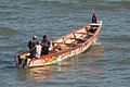
Brightly painted fishing boats are common in Bakau
-
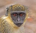
The Gambia's wildlife, like this green monkey, attracts tourists

_juvenile_head.jpg)
See also
 In Spanish: Gambia para niños
