
List of census-designated places in Oklahoma facts for kids
A census-designated place (CDP) is a special area defined by the US Census Bureau. These areas are like small towns or communities where many people live close together, but they aren't officially cities or towns with their own local government.
CDPs don't have their own mayors or city councils, and they don't have official maps like cities do. They were all created in 1980 or later. The Census Bureau uses them to collect information for research. However, CDPs don't replace the real towns or communities that were already there. Most of these CDPs in Oklahoma are found in the northeastern part of the state, but nobody knows exactly why.
Many CDPs are named after the communities found inside them, or after nearby places. We've listed the associated communities when we know them. We found this information in books like Oklahoma Place Names and on government websites like the United States Geological Survey.
List of Oklahoma's CDPs
A
B
- Badger Lee – Seqoyah County
- Ballou – Mayes County
- Bee – Johnston County
- Belfonte – Sequoyah County
- Bell – Adair County
- Bison – Garfield County
- Blackgum – Sequoyah County
- Blue – Bryan County
- Box – Sequoyah County
- Brent – Sequoyah County
- Briggs – Cherokee County
- Brush Creek – Delaware County
- Brushy – Sequoyah County
- Bull Hollow – Delaware County
- Bushyhead – Rogers County
- Butler – Delaware County
C
- Carlisle – Sequoyah County
- Cartwright – Bryan County
- Cayuga – Delaware County
- Cedar Crest – Mayes County
- Cherry Tree – Adair County
- Chester – Major County
- Chewey – Adair County
- Christie – Adair County
- Cleora – Delaware County
- Cloud Creek – Delaware County
- Copeland – Delaware County
D
- Dale – Pottawatomie County
- Deer Lick – Delaware County
- Dennis – Delaware County
- Dodge – Delaware County
- Dotyville – Ottawa County
- Dripping Springs – Delaware County
- Drowning Creek – Delaware County
- Dry Creek – Cherokee County
- Duchess Landing – McIntosh County
- Dwight Mission – Sequoyah County
E
- Eagletown – McCurtain County
- Eldon – Cherokee County
- Elm Grove – Adair County
- Evening Shade – Sequoyah County
F
- Fairfield – Adair County
- Felt – Cimarron County
- Flint Creek – Delaware County
- Flute Springs – Sequoyah County
G
- Gideon – Cherokee County
- Grandview – Cherokee County
- Grant – Choctaw County
- Greasy – Adair County
- Gregory – Rogers County
I
J
- Justice – Rogers County
K
L
- Lane – Atoka County
- Leach – Delaware County
- Lebanon – Marshall County
- Liberty – Sequoyah County
- Limestone – Rogers County
- Long – Sequoyah County
- Longtown – Pittsburg County
- Lost City – Cherokee County
- Lucien – Noble County
- Lyons Switch – Adair County
M
- Marietta – Adair County
- Mazie – Mayes County
- McCord – Osage County
- Meridian – Stephens County
- Mulberry – Adair County
- Murphy – Mayes County
N
- Narcissa – Ottawa County
- Nardin – Kay County
- Nescatunga – Alfalfa County
- New Eucha – Delaware County
- Nicut – Sequoyah County
- Notchietown – Sequoyah County
O
P
- Park Hill – Cherokee County
- Peavine – Adair County
- Peggs – Cherokee County
- Pettit – Cherokee County
- Pin Oak Acres – Mayes County
- Piney – Adair County
- Pinhook Corner – Sequoyah County
- Proctor – Adair County
- Pump Back – Mayes County
R
- Redbird Smith – Sequoyah County
- Remy – Sequoyah County
- River Bottom – Muskogee County
- Rocky Ford – Delaware County
- Rocky Mountain – Adair County
- Rose – Mayes County
S
- Salem – Adair County
- Sams Corner – Mayes County
- Sand Hill – Muskogee County
- Sequoyah – Rogers County
- Shady Grove – Cherokee County
- Shady Grove – McIntosh County
- Short – Sequoyah County
- Simms – Muskogee County
- Snake Creek – Mayes County
- Sour John – Muskogee County
- Sparrowhawk – Cherokee County
- Steely Hollow – Cherokee County
- Stoney Point – Sequoyah County
- Swink – Choctaw County
- Sycamore – Delaware County
T
- Tagg Flats – Delaware County
- Tenkiller – Cherokee County
- Teresita – Cherokee County
- Texanna – McIntosh County
- Tiawah – Rogers County
- Titanic – Adair County
- Turley – Tulsa County
- Turpin – Beaver County
- Tuskahoma – Pushmataha County
- Twin Oaks – Delaware County
W
- Wauhillau – Adair County
- Welling – Cherokee County
- West Peavine – Adair County
- White Oak – Craig County
- Whitesboro – Le Flore County
- White Water – Delaware County
- Wickliffe – Mayes County
- Woodall – Cherokee County
Z
Images for kids
-
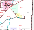
The Tiawah CDP (in yellow) lies east of Oklahoma State Highway 88.
-
The actual Tiawah community lies on either side of Highway 88 in the midst of the Tiawah Hills.


