
Miller Run facts for kids
Quick facts for kids Miller Run |
|
|---|---|

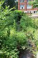
Miller Run looking downstream
|
|
| Physical characteristics | |
| Main source | base of a small hill in East Buffalo Township, Union County, Pennsylvania between 500 and 520 feet (150 and 160 m) |
| River mouth | Limestone Run in Lewisburg, Union County, Pennsylvania 430 ft (130 m) 40°57′38″N 76°53′00″W / 40.96046°N 76.88326°W |
| Length | 1.2 mi (1.9 km) |
| Basin features | |
| Progression | Limestone Run → West Branch Susquehanna River → Susquehanna River → Chesapeake Bay |
| Basin size | 0.87 sq mi (2.3 km2) |
| Tributaries |
|
Miller Run is a small stream, also called a tributary, located in Union County, Pennsylvania. It flows into another stream called Limestone Run. Miller Run is about 1.2 miles (1.9 kilometers) long. It travels through East Buffalo Township and the town of Lewisburg.
The area of land that drains into Miller Run, called its watershed, is about 0.87 square miles (2.25 square kilometers). This stream is very small and sometimes dries up, especially during dry periods. It is often affected by stormwater runoff and carries a lot of sediment, which is like dirt and small rocks. Human activities have also changed the water's natural chemistry. Most of the land in the Miller Run watershed belongs to Bucknell University.
Contents
About Miller Run
Miller Run is a small stream that has been changed a lot by human activity over the years. It has been studied and worked on by Bucknell University to help improve its health. Even though it's small, it's home to some fish species.
Where Miller Run Flows
Miller Run starts at the bottom of a small hill in East Buffalo Township. It flows north for a short distance. Then, it turns and flows north-northeast. Along this path, it crosses under US Route 15. It also flows through the campus of Bucknell University. While on campus, it gets water from a small, unnamed stream joining it from the left side. After this, it enters the town of Lewisburg. Finally, it flows north for a short distance before joining Limestone Run.
Its Tributaries
Miller Run doesn't have any officially named smaller streams that flow into it. However, there is one stream that people unofficially call "North Miller Run." The part of Miller Run that is upstream (before) this unofficial tributary is sometimes called "South Miller Run."
Water Quality and Flow
Miller Run's water is affected by stormwater flows, which means water running off streets and buildings during rain. It also carries a lot of sediment, which can make the water muddy. The lower parts of the stream often don't have water flowing all year round, especially when there's a drought. However, long ago, it used to flow all the time. During heavy rains, the stream can also experience sudden floods.
Human activities have greatly changed the water's chemistry. For example, the amount of dissolved salts and minerals in Miller Run is much higher than in other streams of similar size. The average amount of water flowing in Miller Run is about 0.005 cubic meters per second (0.18 cubic feet per second). But this can increase a lot during storms, sometimes going over 1 cubic meter per second (35 cubic feet per second).
Miller Run acts strangely during rainstorms and when snow melts. In most streams, the water flow peaks in the upper parts first, then in the lower parts. But in Miller Run, this pattern is reversed. The flow can even peak more than once. This happens because a lot of water from storm drains and paved surfaces flows into the stream very quickly.
The amount of sediment in Miller Run can be very high, sometimes over 2287 parts per million. This is more than ten times higher than a nearby stream, Buffalo Creek, which is already known for its high sediment levels. The amount of dissolved oxygen in Miller Run, which fish need to breathe, has been measured between 9 and 11 milligrams per liter.
Chemical Levels in the Water
In 2009, scientists measured different chemicals in Miller Run.
- The amount of ammonium was low, less than ten milligrams per liter.
- Nitrate was about 1.9 to 1.98 milligrams per liter.
- Phosphorus was very low, less than 0.1 milligrams per liter.
- Sulfate was 34 milligrams per liter in the upper parts and 48 milligrams per liter in the lower parts.
- Chloride was 81.7 milligrams per liter in the upper parts and 47.9 milligrams per liter in the lower parts.
Other elements were also measured:
- Sodium was 32.2 milligrams per liter in the upper parts and 21.9 milligrams per liter in the lower parts.
- Potassium was 3.2 milligrams per liter in the upper parts and 2.8 milligrams per liter in the lower parts.
- Magnesium and calcium were also present, with slightly different amounts in the upper and lower parts.
- Many heavy metals like chromium, manganese, iron, nickel, copper, zinc, arsenic, cadmium, and lead were found in very small or undetectable amounts.
The pH of Miller Run, which tells us how acidic or basic the water is, ranged from about 7.6 to 8.1 in April 2009. This means the water is slightly basic. The specific conductivity, which measures how well water conducts electricity, was between 400 and 600 micro-siemens per centimeter. This high conductivity is partly due to road salt used in winter, which adds sodium, chloride, and potassium to the stream when snow melts.
The average rainfall in the Miller Run watershed is about 1.04 meters (3.4 feet) per year. The water temperature of the stream in April 2009 ranged from about 7 to 12 degrees Celsius (45 to 54 degrees Fahrenheit).
Geography and Geology

The elevation of Miller Run where it joins Limestone Run is about 430 feet (130 meters) above sea level. Where the stream begins, its elevation is between 500 and 520 feet (150 and 160 meters) above sea level. The land in the watershed slopes gently, with an average slope of 3.12 degrees. Like most streams, the steepest part is near where it starts.
The main rock formations in the Miller Run watershed are sedimentary rocks that formed during the Silurian period.
- In the southern part, the bedrock is red shale and sandstone from the Bloomsburg Formation.
- In the middle, there's greenish-yellow sandstone from the Wills Creek Formation.
- In the northern part, there's limestone from the Keyser-Tonoloway Formation.
The top layer of soil and loose sediment in much of the watershed is from the Pleistocene period. This includes a yellow-to-tan silt called loess, which can be several inches to 8 feet (2.4 meters) deep. There are also areas with gravelly till and outwash sediment. The banks of the stream are unstable in some places, especially in the middle and lower sections.
Miller Run is described as a "tiny stream" that looks more like a drainage ditch than a natural stream. It has many features typical of a suburban stream. Historically, farmers changed the stream to make more room for crops. More recently, culverts (underground pipes), concrete channels, and paved areas built by Bucknell University have further changed it. There are more than a dozen blockages along the stream. Many culverts on the stream cannot handle a 100 year flood, which is a very large flood that has a 1% chance of happening in any given year. In some areas, the stream flows through underground pipes.
The Miller Run Watershed
The watershed of Miller Run covers an area of 0.87 square miles (2.25 square kilometers). This entire area is located within the Lewisburg quadrangle map.
About 80 percent of the land in the Miller Run watershed is owned by Bucknell University. The land is used for various purposes, including:
- An urban college campus.
- A golf course.
- A new housing development.
- Suburban areas on the edge of the watershed.
About 37.5 percent of the watershed is urban land, and 13.1 percent is forested land.
Miller Run has been described as "not appealing" on the university campus. It can also cause damage to buildings during high water flows. There have been suggestions to create Wetlands near the stream to help hold back stormwater. The Music and Arts Building is built directly over the stream in one spot. Removing this part of the building has been suggested to reduce flooding and help the stream return to a more natural state. In one area, Miller Run flows past private land that was built on an old coal ash landfill.
History of Miller Run
Miller Run was officially added to the Geographic Names Information System on October 1, 1992.
Over time, Miller Run has been significantly changed to help it carry away stormwater more effectively. As early as the 1930s, people were changing the stream's path and creating flat areas (terracing) in its floodplain. By the 1940s, a part of the stream near the old Davis Gymnasium had been straightened and channelized, but there were no rocks (riprap) placed to protect the banks yet. By the 1950s, many culverts and extensive channelization were present along the stream.
Around 2011, a big research project took place on Miller Run. It involved 80 students and 11 professors. The project used GIS mapping, drone flights, and collected water and sediment samples. This project built upon earlier studies and a stream restoration course taught at Bucknell University. In 2010, the Pennsylvania Department of Environmental Protection gave Bucknell University a $178,000 Growing Greener grant. This money was for restoring the upper parts of the stream.
The Bucknell University golf course is near Miller Run. In 2015, a stream restoration project caused some complaints from golf course users. They said the project had dried up the area, making the driving range look "like a desert," and that business had dropped a lot. They also questioned if the project was truly scientific, as the stream had very little water in it. However, Bucknell University states that this project, which received another $270,000 Growing Greener grant, "could change the way stream monitoring and restoration is carried out statewide."
Wildlife in Miller Run
The Pennsylvania Department of Environmental Protection considers Miller Run a Warmwater Fishery. This means it's suitable for fish that prefer warmer water. In a 2009 study, scientists found 23 individual fish belonging to six different species in the stream.
- In the upper parts, they found 20 fish from six species: bluegill sunfish, central stoneroller, creek chub, cutlips minnow, common shiner, and pumpkinseed sunfish.
- Further downstream, only three creek chubs were found. Most of the fish observed at both locations were adults.
Miller Run has a very low number of benthic macroinvertebrates. These are small creatures without backbones that live at the bottom of the stream, like insects and worms. On a scale of 0 to 100, Miller Run scored between 14.47 and 25.82. Scores below 63 mean the water body is unhealthy. The variety of macroinvertebrates is also very low. Only a small percentage of these creatures are sensitive to pollution (25 percent in the upper parts, 10 percent in the middle, and 5 percent in the lower parts).
Common types of macroinvertebrates found in Miller Run include:
- Diptera (flies)
- Amphipoda (small crustaceans)
- Turbellaria (flatworms)
- Isopoda (woodlice-like creatures)
- Oligochaeta (earthworm-like creatures)
Much of Miller Run lacks riparian vegetation, which are plants and trees along the stream banks. However, people from Bucknell University have been planting and growing trees along the stream to help improve its health.
Miller Run has been evaluated using a method from the Pennsylvania Department of Environmental Protection. On a scale from 0 to 240, it scored between 59 (poor) and 122 (marginal), depending on the section of the stream. The scores got worse as the stream flowed downstream through the Bucknell University campus. The amount of Chlorophyll a in Miller Run, which indicates algae growth, ranges from 2 to 12 micrograms per square centimeter. This amount can change even at the same spot, and generally increases further downstream.
Images for kids
-
Miller Run looking upstream
