
Mississauga facts for kids
Quick facts for kids
Mississauga
|
|||||
|---|---|---|---|---|---|
| City of Mississauga | |||||
|
From top, left to right: Mississauga City Centre, the Mississauga Civic Centre, Health Sciences Complex at the University of Toronto Mississauga, Old Grammar School in Streetsville, the Credit River, 282 Church Street, and Absolute World towers, the St. Lawrence bay in Port Credit, and the M City Condominiums
|
|||||
|
|||||
| Motto(s):
Pride in our past, faith in our future Leading Today for Tomorrow
|
|||||

Mississauga
Location in Regional Municipality of Peel

Mississauga
Location in Southern Ontario
|
|||||
| Country | Canada | ||||
| Province | Ontario | ||||
| Region | Peel | ||||
| Toronto Township | 1805 | ||||
| Town of Mississauga | 1968 | ||||
| Incorporation as the City of Mississauga | 1974 | ||||
| Area | |||||
| • Total | 292.43 km2 (112.91 sq mi) | ||||
| Elevation | 156 m (512 ft) | ||||
| Population
(2021)
|
|||||
| • Total | 717,961 (7th) | ||||
| • Density | 2,467.60/km2 (6,391.1/sq mi) | ||||
| Time zone | UTC−05:00 (EST) | ||||
| • Summer (DST) | UTC−04:00 (EDT) | ||||
| Forward sortation area |
L4T to L5W & M7R
|
||||
| Area code(s) | 905, 289, 365, and 742 | ||||
| Demonym |
|
||||

.jpg)


.jpg)


Mississauga is a large Canadian city in Ontario. It sits on the western shore of Lake Ontario. The city is part of the Regional Municipality of Peel. It borders Toronto to the east and Brampton to the north. Milton is to the northwest, and Oakville is to the southwest.
In 2021, Mississauga had a population of 717,961 people. This makes it the seventh-largest city in Canada. It is the third-largest in Ontario and the second-largest in the Greater Toronto Area (GTA), after Toronto. For the first time in its history, the city's population slightly decreased in 2021.
Mississauga grew quickly because it is close to Toronto. Over time, it became a diverse and multicultural city. It developed its own busy downtown area, called Mississauga City Centre. Toronto Pearson International Airport, Canada's busiest airport, is in Malton, a neighborhood in Mississauga. Many Canadian and international companies also have their main offices here. Mississauga is not a traditional city. It was formed by joining three villages, two townships, and several small communities. These places grew together into one large urban area.
Indigenous people have lived in this area for thousands of years. Mississauga is on the traditional lands of the Huron-Wendat, Haudenosaunee, and Anishinaabeg peoples. This includes the Mississaugas, who the city is named after. Most of what is now Mississauga was first called Toronto Township in 1805. It became a town in 1968 and a city in 1974.
Contents
- What's in a Name?
- A Look at Mississauga's Past
- Mississauga's Location and Landscape
- Who Lives in Mississauga?
- Mississauga's Economy
- Fun Things to Do in Mississauga
- Places to Visit
- Sports in Mississauga
- Getting Around Mississauga
- City Services
- Learning in Mississauga
- Mississauga in the News
- Sister City
- Famous People from Mississauga
- City Honors
- Images for kids
- See also
What's in a Name?
The name Mississauga comes from the Anishinaabe language. The word means "Those at the Great River-mouth."
People also use shorter names like Sauga. Residents are sometimes called Saugans or Mississaugans.
A Look at Mississauga's Past
Early People and Settlements
People have lived in the Mississauga area for a very long time. Archaeologists have found tools from as far back as 9000 BCE. Back then, Lake Ontario was much smaller.
Later, around 8000–1000 BCE, more people lived here. They gathered at rivers like the Credit River to catch fish. They also collected nuts and wild rice.
From 1000 BCE to 1650 CE, the population continued to grow. People started using pottery and building semi-permanent villages. They traded with other groups far away.
Around 500–1650 CE, people began farming crops like corn, beans, and squash. This led to the Wyandot (Huron) culture. Villages with many longhouses were built along the Credit River.
Arrival of New Groups
Around 1650, the Haudenosaunee, another Indigenous group, moved into the area. They fought with the Wyandot, who then left. By 1687, the Haudenosaunee also left the north shore of Lake Ontario.
The Algonquian-speaking Anishinaabe Ojibwe people then moved into the Credit River Valley. European traders met them at the mouth of the Credit River. They gave the Anishinaabe "credit" for the next year's trade. This is how the Anishinaabe bands in this area became known as the Credit River Mississaugas.
In 1805, officials from York (now Toronto) bought 85,000 acres of land from the Mississaugas. This land became Toronto Township. More land was bought in 1818. Mississauga is covered by four treaties in total.
How Mississauga Grew
Early villages in the area included Clarkson, Cooksville, and Port Credit. The land was given to United Empire Loyalists who came from the United States. The government wanted to develop the area. In 1847, the Mississaugas were moved to a reserve near Hagersville.
For much of the 19th and early 20th centuries, Mississauga was mostly farmland. People built cottages along Lake Ontario for weekend getaways.
The Queen Elizabeth Way (QEW) highway opened in 1935. This helped the area grow. In 1937, land was sold to build Malton Airport, which later became Toronto Pearson International Airport.
After World War II, Toronto Township started to grow into a suburb. New communities like Erin Mills and Meadowvale were built. By 2005, most of Mississauga was developed.

In 1968, Toronto Township became the Town of Mississauga. The community of Malton joined it. Port Credit and Streetsville remained separate at first. But in 1974, they also joined Mississauga when it became a city. That same year, Square One Shopping Centre opened.
The Great Train Evacuation
On November 10, 1979, a freight train carrying dangerous chemicals derailed in Mississauga. One car exploded, and others carried chlorine gas. Officials decided to evacuate 218,000 people. This was the largest peacetime evacuation in North American history at the time. Everyone returned home safely. Many cities later studied Mississauga's emergency plan.
In 2010, Mississauga bought 400 acres of land from Milton. Also in 2010, the Mississaugas and the Canadian government settled a land claim. The Indigenous band received $145 million for their land.
Mississauga's Location and Landscape
.jpg)
Mississauga covers about 288 square kilometers of land. It has 13 kilometers of shoreline along Lake Ontario.
The city is bordered by Oakville and Milton to the west. Brampton is to the north, and Toronto is to the east. Lake Ontario is to the south.
Two main rivers flow into Lake Ontario through Mississauga. The Credit River is the longest. It divides the western part of the city from the central and eastern parts. Its valley is protected by the Credit Valley Conservation Authority.
Etobicoke Creek forms part of Mississauga's eastern border with Toronto. This creek caused heavy flooding during Hurricane Hazel in 1954. Now, houses are not built along the floodplain.
Most of Mississauga's land drains into these two river systems. The city's elevation ranges from 214 meters (699 feet) in the west to 76 meters (249 feet) at Lake Ontario.
On August 17, 2024, heavy rain caused local flooding. This led to traffic problems and road closures.
Mississauga's Neighborhoods

Mississauga has 25 neighborhoods. Here are some of them:
- Applewood
- Central Erin Mills
- Churchill Meadows
- Clarkson
- Cooksville
- Creditview
- Dixie
- East Credit
- Erin Mills
- Erindale
- Fairview
- Hurontario
- Lakeview
- Lisgar
- Lorne Park
- Malton
- Meadowvale
- Meadowvale Village
- Mineola
- Mississauga Valleys
- Port Credit
- Rathwood
- Rockwood Village
- Sheridan
- Streetsville
Mississauga's Weather
Mississauga has a moderate climate, similar to Toronto's. Summers can be hot and humid. Temperatures can go above 32°C (90°F). Winters are cold, with temperatures often below freezing. It can drop to -15°C (5°F) for short periods.
The city gets about 108.5 cm (42.7 inches) of snow each winter. Fog is more common near the lake and in the Credit River Valley. Northern parts of the city often get more snow than areas closer to Lake Ontario.
Thunderstorms are usually not severe. However, a strong tornado hit Mississauga in 1923, killing four people. Another tornado caused damage in 1985.
Who Lives in Mississauga?
| Historical populations | ||
|---|---|---|
| Year | Pop. | ±% |
| 1971 | 172,352 | — |
| 1976 | 250,017 | +45.1% |
| 1981 | 315,055 | +26.0% |
| 1986 | 374,005 | +18.7% |
| 1991 | 463,388 | +23.9% |
| 1996 | 544,382 | +17.5% |
| 2001 | 612,925 | +12.6% |
| 2006 | 668,549 | +9.1% |
| 2011 | 713,443 | +6.7% |
| 2016 | 721,599 | +1.1% |
| 2021 | 717,961 | −0.5% |
In 2021, Mississauga had 717,961 people. About 15.2% of the population was under 15 years old. About 16.6% was 65 years or older. The average age in Mississauga was 40.8 years.
Many Cultures and Backgrounds
Mississauga is a very diverse city. Here are some of the largest groups:
Beliefs and Religions
| Religions in Mississauga | ||||
|---|---|---|---|---|
| Religion | Per cent | |||
| Christianity | 49.9% | |||
| None | 18.1% | |||
| Islam | 17.0% | |||
| Hinduism | 8.8% | |||
| Sikhism | 3.4% | |||
| Buddhism | 2.0% | |||
| Distribution of religions throughout Mississauga | ||||
In 2021, the most common religion in Mississauga was Christianity (49.9%). This includes many different Christian groups. Other major religions include:
About 18.1% of people said they had no religious affiliation.
Languages Spoken
In 2021, English was the main language spoken at home for 44.9% of the population. Other common languages include:
Most people in Mississauga (96.5%) know English. About 6.8% know French.
Mississauga's Economy
Many large companies have their main offices in Mississauga. Over 60 of the Fortune 500 companies (the biggest companies in the world) have offices here. Key industries include medicine, banking, electronics, aerospace, and transportation.
Companies like TD Bank, Royal Bank of Canada, Purolator Inc., and Laura Secord Chocolates have their headquarters in Mississauga. Walmart, Kellogg's, Panasonic, and Hewlett-Packard also have Canadian headquarters here. Mississauga is also a center for aerospace companies like Magellan Aerospace and Honeywell Aerospace.
Fun Things to Do in Mississauga
Mississauga has a lively arts scene. The Mississauga Arts Council celebrates local artists, musicians, and filmmakers every year.
Many big events happen at Celebration Square:
- Canada Day Celebration
- Mississauga Rotary Ribfest
- Tree Lighting Ceremony
- New Year's Eve Bash
One of the most popular events is Carassauga. This festival of cultures happens every May. It is the second-largest cultural festival in Canada. Countries set up pavilions to show their food, dance, and goods. Visitors can use their ticket for free public transport to explore the city and its pavilions.
Other cultural festivals include Fiesta Ng Kalayaan (for the Philippines), Viet Summerfest (for Vietnam), and Muslimfest. There's also Diwali, an Indian festival, and Mosaic Festival, a large South Asian arts festival.
The annual Bread and Honey Festival is held in Streetsville. This event celebrates the village's founding. It includes a race that raises money for charities.
Port Credit hosts many festivals. These include Buskerfest (street performers), "Paint the Town Red" for Canada Day, and the Mississauga Waterfront Festival. The Tim Hortons Southside Shuffle is a popular Blues and Jazz Festival.
The Malton neighborhood has a large Sikh community. They hold an annual Khalsa Day parade with over 100,000 people attending.
Mississauga also has a significant Jewish community with many activities.
Mississauga Library System

The Mississauga Library System has 18 libraries across the city.
Places to Visit
Mississauga Celebration Square

Mississauga Celebration Square is a popular public space. It has a permanent stage, a large ice rink (which is a fountain in summer), and big media screens. It opened in 2011.
The square hosts many free events:
- Outdoor concerts
- Fitness classes
- Amphitheater performances
- Movie nights
- Skate parties in winter
In 2012, the square welcomed its one millionth visitor!
Art Gallery of Mississauga
The Art Gallery of Mississauga (AGM) is a public art gallery. It is located in the Mississauga Civic Centre, near Celebration Square. The AGM offers free admission and tours. It has over 500 art pieces.
Shopping Centers


- Square One Shopping Centre is in the City Centre. It is the second-largest mall in Canada. It has over 350 stores and attracts 24 million visitors each year. It opened in 1973.
- Erin Mills Town Centre is the second-largest mall in Mississauga. It opened in 1989.
- Dixie Outlet Mall is Canada's largest enclosed outlet mall. It opened in 1956.
- Heartland Town Centre is a large outdoor shopping area with 180 stores.
- The Fantastic Flea Market is Mississauga's oldest flea market, opened in 1976.
Parks and Recreation

Mississauga has over 481 parks and woodlands. There are nearly 100 km of trails for walking and biking.
- Kariya Park is a Japanese garden in the city center. It opened in 1992 and is named after Mississauga’s sister city, Kariya, Japan.


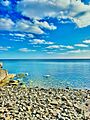
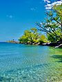
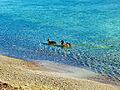
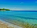
Beaches
Since 2016, Mississauga has worked hard to improve its lakeshore. They clean up garbage daily and check water quality. Now, Mississauga has some of the cleanest beaches in the Greater Toronto Area. These beaches attract many locals and tourists.
The most popular beaches are Jack Darling Memorial Park, RK McMillan Park, and St. Lawrence Park in Port Credit. Lake Aquitaine also has a boardwalk.
Sports in Mississauga

The Paramount Fine Foods Centre is Mississauga's main sports venue. It is home to the Raptors 905, a basketball team. The arena also hosts other sports like hockey.
Mississauga has many hockey teams, including the Mississauga Chiefs and the Mississauga Chargers. There are also teams for box lacrosse, cricket, and Canadian football. The Mississauga Football League (MFL) is a youth program for players aged 7–17.
The Mississauga Marathon is held annually. It is a qualifying race for the Boston Marathon.
Mississauga has also hosted major sports events like:
- The 2000 IIHF Women's World Championship
- The 2017 ISU World Junior Synchronized Skating Championships
- The 2022 Ontario Summer Games
Getting Around Mississauga
Trains
Mississauga has three major railway lines. Via Rail trains pass through the city and stop at Malton GO Station. Other Via Rail services stop in nearby cities.
GO Transit provides commuter train service. The Lakeshore West line runs all day. The Kitchener and Milton lines run during busy rush hours.
Buses
MiWay is the city's public bus service. It has over 60 routes across the city. MiWay connects with GO Transit, Brampton Transit, Oakville Transit, and the Toronto Transit Commission (TTC). MiWay has local routes ("MiLocal") and express routes ("MiExpress").
Bus Rapid Transit
The Mississauga Transitway is a special bus-only road with 12 stations. It runs parallel to Highway 403. It was completed in 2017. This service also connects to Kipling Subway Station in Toronto.
Light Rail Transit (LRT)
Plans are underway for an LRT line along Hurontario Street. It will stretch from Port Credit to southern Brampton. The provincial government is fully funding this project. Construction began in 2018 and is expected to finish by mid-2025.
Toronto Subway Extension
There are plans to extend Toronto's Line 5 Eglinton subway into Mississauga by 2030–2031. This will bring the Toronto Subway into the city. There will be four stops in Mississauga, including one at Toronto Pearson International Airport.
Highways
Several major highways run through or near Mississauga:
- Highway 401 (Macdonald-Cartier Freeway) passes through the north end.
- Highway 403 is the main freeway in the city. It runs through the City Centre.
- The Queen Elizabeth Way (QEW) runs through the southern half of the city.
- Highway 410 goes north to Brampton.
- Highway 409 provides access to Toronto Pearson International Airport.
- Highway 407 runs near the northern city limits.
- Highway 427 forms part of the Toronto-Mississauga border.
Air Travel

Lester B. Pearson International Airport (YYZ) is in northeastern Mississauga. It is the largest and busiest airport in Canada. In 2015, it handled over 41 million passengers. Pearson is a major hub for Air Canada and WestJet. It serves over 180 destinations worldwide.
Biking in the City
In 2010, Mississauga approved a plan to build over 900 km of cycling routes. The goal is to make cycling a common way to get around. The plan focuses on safety for cyclists.
As of 2024, many major roads have bike paths. For roads without dedicated lanes, signs and markings show that bikes can use the shoulder or the right-most lane.
City Services
Emergency Services
- Peel Regional Police handle policing in Mississauga and at the airport.
- The Ontario Provincial Police patrol provincial highways.
- Mississauga Fire and Emergency Services provide fire fighting.
- Peel Regional Paramedic Services provide emergency medical care.
- Toronto Pearson Airport also has its own fire department.
Healthcare
Mississauga has two main hospitals: Credit Valley Hospital and Mississauga Hospital. They are part of the Trillium Health Partners group.
Learning in Mississauga

Mississauga is home to the University of Toronto Mississauga (UTM). It is one of three campuses of the University of Toronto. UTM has about 13,200 students and is growing. It has 15 academic departments and many programs. The Mississauga Academy of Medicine is also on campus.

Sheridan College opened a new campus in Mississauga in 2011. It focuses on business education and helping new Canadians join the workforce. The campus can hold 5,000 students.
Mississauga has over 150 schools. They are run by four different school boards:
- Peel District School Board (public English schools)
- Dufferin-Peel Catholic District School Board (Catholic English schools)
- Conseil scolaire Viamonde (public French schools)
- Conseil scolaire de district catholique Centre-Sud (Catholic French schools)
Many schools offer special programs, such as:
- French immersion
- Regional Arts Program
- International Business and Technology Program
- International Baccalaureate Program
- Sci Tech Program
- Regional Enhanced Program
- Regional Sports Program
Mississauga in the News
Mississauga is part of the Toronto media market. It is served by Toronto-based media. However, Mississauga also has its own local news:
- The Mississauga News: A regional newspaper published twice a week in print and daily online.
- Sunday Times: A community newspaper for the South Asian community.
- Modern Mississauga: A bi-monthly magazine.
The city also has three local radio stations:
- AM 960 CKNT: Local news and talk radio.
- AM 1650 CINA: A multicultural station for Indian and Pakistani audiences.
- FM 91.9 CFRE: The campus radio station for the University of Toronto Mississauga.
Several national TV channels also broadcast from Mississauga, including Rogers Television and The Shopping Channel.
Sister City
Mississauga has one sister city:
Both cities have a park and a road named after each other.
- In Mississauga: Kariya Park and Kariya Drive.
- In Kariya: Mississauga Park, Mississauga Dori, and Mississauga Bridge.
The Mississauga Friendship Association helps with this twinning program.
Famous People from Mississauga
Many notable people have come from Mississauga.
City Honors
The Freedom of the City is the highest honor a Canadian city can give. These people and military units have received this honor in Mississauga:
Individuals
- Hazel McCallion: April 12, 2017.
- Bianca Andreescu: September 15, 2019.
- Mohamad Fakih: November 15, 2019.
- Members of the Band Triumph (Rik Emmett, Mike Levine and Gil Moore): November 25, 2019.
Military Units
- The Lorne Scots Regiment: July 2, 2014.
- The Toronto Scottish Regiment: September 20, 2014.
Images for kids
-
Tall Oaks Park
-
The Shallows at St. Lawrence Park
-
Jack Darling Memorial Park
-
Hiawatha Park
See also
 In Spanish: Mississauga para niños
