National Weather Service Topeka, Kansas facts for kids
 |
|
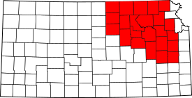
 The 23 counties in northeastern Kansas served by the Topeka NWS Forecast Office |
|
| Agency overview | |
|---|---|
| Type | Meteorological |
| Jurisdiction | Federal Government of the United States |
| Headquarters | 1116 NE Strait Avenue, Topeka, Kansas 66616-1667 39°04′21″N 95°37′52″W / 39.072399°N 95.631106°W |
| Employees | 21 |
| Agency executives |
|
| Parent agency | National Weather Service |
The National Weather Service – Topeka, Kansas (often called TOP) is a local weather office. It is part of the larger National Weather Service in the United States. This office is located in Topeka, which is the capital city of Kansas. You can find its offices close to the Philip Billard Municipal Airport.
The Topeka Weather Office helps keep people safe by providing important weather and emergency information. It covers 23 counties across north-central, northeast, and east-central Kansas. Many towns rely on this office for their daily weather forecasts and warnings about severe storms. Some of these communities include Abilene, Emporia, Lawrence, Manhattan, and Topeka itself.
NOAA Weather Radio: Your Weather Friend
The Topeka National Weather Service office runs five special radio stations. These stations are called NOAA Weather Radio transmitters. They send out important weather forecasts, watches, warnings, and other updates to everyone. Each of these transmitters is very powerful, broadcasting with 1000 watts of power. This helps make sure the weather information reaches a wide area.
How NOAA Weather Radio Works
NOAA Weather Radio is like a dedicated weather channel on your radio. It broadcasts 24 hours a day, 7 days a week. It gives you the latest information directly from the National Weather Service. This is super helpful during fast-changing weather, like thunderstorms or blizzards.
Main Transmitters in the Topeka Area
The Topeka office manages several transmitters to cover its large area:
- WXK91, Maple Hill/Topeka: This transmitter is located near Maple Hill. It broadcasts at 162.475 MHz. It serves many counties, including Douglas, Geary, Jackson, Jefferson, Pottawatomie, Riley, Shawnee, and Wabaunsee. A small part of its signal also reaches Atchison, which is mainly covered by the Pleasant Hill, MO Forecast Office.
- WXK94, Concordia: This transmitter is based in Concordia. It broadcasts at 162.550 MHz. It covers counties like Clay, Cloud, Ottawa, Republic, and Washington. It also reaches parts of Jewell and Mitchell, which are mostly covered by the Hastings, NE Forecast Office.
- WXL71, Abilene: Located in Abilene, this transmitter broadcasts at 162.525 MHz. It serves counties such as Clay, Dickinson, Geary, Morris, Ottawa, and Riley. Some of its signal also reaches Marion, McPherson, and Saline counties, which are primarily served by the Wichita, KS Forecast Office.
- KZZ67, Blue Rapids: This transmitter is in Blue Rapids. It broadcasts at 162.425 MHz. It provides weather information to Marshall, Nemaha, Pottawatomie, Riley, and Washington counties.
 | James Van Der Zee |
 | Alma Thomas |
 | Ellis Wilson |
 | Margaret Taylor-Burroughs |

