
Plymouth, Massachusetts facts for kids
Quick facts for kids
Plymouth, Massachusetts
|
|||
|---|---|---|---|
|
Town
|
|||
      Left–right from top: Plymouth Rock monument, Plimoth Patuxet, National Monument to the Forefathers, Burial Hill, Town Center, First Parish Church in Plymouth
|
|||
|
|||
| Nickname(s):
America's Hometown
|
|||

Location in Plymouth County, Massachusetts
|
|||

Plymouth, Massachusetts
Location in Massachusetts

Plymouth, Massachusetts
Location in the United States
|
|||
| Country | United States | ||
| State | Massachusetts | ||
| County | Plymouth | ||
| Region | New England | ||
| Settled | 1620 | ||
| Incorporated | 1620 | ||
| Named for | Plymouth, England | ||
| Government | |||
| • Type | Representative town meeting | ||
| Area | |||
| • Total | 134.0 sq mi (347.0 km2) | ||
| • Land | 96.5 sq mi (249.8 km2) | ||
| • Water | 37.5 sq mi (97.2 km2) | ||
| Elevation | 187 ft (57 m) | ||
| Population
(2020)
|
|||
| • Total | 61,217 | ||
| • Density | 634.4/sq mi (245.1/km2) | ||
| Time zone | UTC-5 (Eastern) | ||
| • Summer (DST) | UTC-4 (Eastern) | ||
| ZIP Codes |
02345, 02360–02362, 02381
|
||
| Area code(s) | 508/774 | ||
| FIPS code | 25-54310 | ||
| GNIS feature ID | 0618349 | ||
| Website | www.plymouth-ma.gov | ||


Plymouth is a town in Plymouth County, Massachusetts, United States. It's often called "America's Hometown" because of its important role in American history. In 1620, the Pilgrims arrived here on the Mayflower and started the Plymouth Colony. This was the first permanent European settlement in New England.
Plymouth is famous for hosting the First Thanksgiving feast. It was the capital of Plymouth Colony until 1691. An English explorer named John Smith first named this area Plymouth in 1614. He also named the whole region 'New England'. Later, the Mayflower sailed from Plymouth, England, to this new Plymouth.
The town is about 40 miles (64 km) south of Boston. In the 1800s, Plymouth was known for making ropes, fishing, and shipping. The Plymouth Cordage Company was once the biggest rope-making company in the world. Today, tourism is its main industry. Plymouth is the largest town in Massachusetts by land area. In 2020, its population was 61,217 people.
Contents
- History of Plymouth
- Geography of Plymouth
- Climate and Weather
- Population and People
- Economy: How Plymouth Makes Money
- Education: Schools in Plymouth
- Healthcare: Hospitals and Medical Care
- Transportation: Getting Around Plymouth
- Sports
- Points of Interest: What to See in Plymouth
- Notable People from Plymouth
- Sister Cities: Plymouth's International Friends
- Images for kids
- See also
History of Plymouth
Early Days: Before the Pilgrims Arrived
Before the Pilgrims came, the area of Plymouth was home to the Wampanoag tribe. Their village was called Patuxet. European explorers visited the region before the Pilgrims settled. In 1605, French explorer Samuel de Champlain sailed into Plymouth Harbor. He called it Port St. Louis.
Captain John Smith, who helped lead the Jamestown, Virginia colony, explored this area in 1614. He is the one who named the region "New Plimouth." Sadly, between 1614 and 1617, two serious diseases affected the Wampanoag people. These diseases killed most of the tribe. This left their cornfields and cleared land empty for the Pilgrims to use.
Colonial Era: The Pilgrims Arrive

Plymouth played a very important part in early American history. It was the final landing spot for the Mayflower ship. It was also where the Plymouth Colony was first settled. Plymouth was started in December 1620 by a group of Puritans. They had separated from the Church of England because they wanted to make more changes to the church. Today, we know these settlers as the "Pilgrims."
The Mayflower first stopped in Provincetown, Massachusetts on November 11, 1620. The ship was supposed to go to the Hudson River. But it didn't go past Cape Cod. The Pilgrims realized they didn't have permission to settle there. So, they signed the Mayflower Compact before getting off the ship. They looked for a good place to settle around Cape Cod Bay. On December 17, they found the calm waters of Plymouth Harbor. After three days of looking, they found a spot for their new settlement.
The settlers officially landed on December 21, 1620. People traditionally say the Pilgrims first stepped onto America at Plymouth Rock. However, there is no old record that proves this.

The First Winter: A Time of Hardship
The Plymouth colony faced many challenges during its first winter. They were at risk of starving and didn't have good shelters. From the start, the colonists needed help from the Native Americans. One colonist wrote in his journal about finding corn: "We marched to the place we called Cornhill, where we had found the corn before. At another place we had seen before, we dug and found some more corn, two or three baskets full, and a bag of beans. ... In all we had about ten bushels, which will be enough for seed. It is with God's help that we found this corn, for how else could we have done it, without meeting some Indians who might trouble us."
Earlier, the Pilgrims had found a Native American burial site with corn. They took this corn for planting. Another time, they found an empty house and took corn and beans. They paid the owners back about six months later.
Even more help came from Samoset and Tisquantum, known as Squanto. Squanto was a Native American sent by Wampanoag Chief Massasoit. He was like an ambassador and helper. Squanto had been taken in 1614 and sold into slavery in Spain. He escaped and returned home in 1619. He taught the colonists how to grow corn and how to catch fish. He also taught them other useful skills for their new home. He was very important for the settlement's survival for the first two years.
Squanto and Hobomok, another guide from Massasoit, helped the colonists set up trading posts for furs. Chief Massasoit later made a peace treaty with the Pilgrims. After a good harvest in the fall of 1621, the Pilgrims celebrated. They gathered with Squanto, Samoset, Massasoit, and ninety other Wampanoag men. This celebration of thanks for their harvest is known as the First Thanksgiving. Today, it is celebrated every year in downtown Plymouth with a parade. Since 1941, Thanksgiving has been a national holiday in the United States.

Plymouth was the capital of Plymouth Colony from 1620 until 1691. In 1691, the colony joined with the Massachusetts Bay Colony. This formed the Province of Massachusetts Bay. Plymouth was the first lasting European settlement in New England. It is also one of the oldest European settlements in what is now the United States.
Revolutionary War: Plymouth's Role
During the Revolutionary War, Colonel Theophilus Cotton of Plymouth led the local militia. When news of the Battles of Lexington and Concord reached Plymouth, Cotton gathered his soldiers. They marched to the town of Marshfield. A small British army camp was there. Cotton's forces surrounded the British troops. But Cotton decided not to shoot. He let the British escape by water and return to their forces in Boston.
19th Century: Industry and Growth

In the 1800s, Plymouth was a quiet coastal town. Its main jobs were fishing and shipping. The town grew into a center for shipbuilding and fishing. Its most important business was the Plymouth Cordage Company, started in 1824. This company became the world's largest maker of rope. At one time, the longest rope-making building in the world was at the Cordage Company's site. It was a quarter-mile (0.4 km) long.
The company did well until the 1960s. But it closed in 1964 because of competition from new ropes made of synthetic fibers. The old factory buildings have been updated. Now they are used for offices, restaurants, and stores. This area is called Cordage Commerce Center.
Modern History: A Growing Town
Plymouth has grown quickly since the late 1900s. It became easier to reach Boston in the early 1970s. This was thanks to better roads, highways, and bus routes. The town's lower land costs and taxes also attracted many new residents. Its population jumped from 18,606 people in 1970 to 45,608 in 1990. That's a 145% increase in 20 years!
Plymouth has more people than some Massachusetts cities. But it is still officially a town. It is governed by a board of selectmen, not a mayor.
Geography of Plymouth

Plymouth is located at 41.95833 degrees North latitude and -70.66778 degrees West longitude. The town covers a total area of 134.0 square miles (347.0 km2). Of this, 96.5 square miles (249.8 km2) is land, and 37.5 square miles (97.2 km2) (28%) is water.
Plymouth has the largest land area of any town in Massachusetts. It includes several neighborhoods and areas. Some larger parts of town are Plymouth Center, North, West and South Plymouth, Manomet, Cedarville, and Saquish Neck.
Plymouth forms the entire western shore of Cape Cod Bay. It shares land borders with Bourne to the southeast, Wareham to the southwest, Carver to the west, and Kingston to the north. It also has a small border with Duxbury. Plymouth is about 44 miles (71 km) southeast of Boston. It is also about the same distance east of Providence, Rhode Island.

Plymouth is in the Plymouth Pinelands and has many unique natural features. The town's Atlantic coast has low plains. But its western parts are very hilly and covered in forests. Plymouth has many small ponds in its western area. The largest is the Great Herring Pond. A major part of the town is the Myles Standish State Forest in the southwest. There is also a smaller town forest, along with parks, recreation areas, and beaches.
Plymouth has nine public beaches. The biggest is Plymouth Beach. This beach protects Plymouth Harbor. It is a three-mile (5 km) long barrier beach that is important for nature. Clark's Island, a small island in Plymouth Bay, is the only island in Plymouth. It has nine summer houses but no one lives there all year.
Climate and Weather

Plymouth has a humid continental climate. This is the main climate type for Massachusetts. Because it is on the Atlantic Ocean, the air can be very humid all year. Plymouth's coastal location means it has warmer temperatures than many places inland in New England. Summers are usually hot and humid. Winters are cold, windy, and often snowy.
July is Plymouth's warmest month. The average high temperature is 84.0 °F (28.9 °C). The average low is 64.1 °F (17.8 °C). January is the coldest month. The average high is 41.0 °F (5.0 °C). The average low is 21.8 °F (-5.7 °C).
Like the rest of the Northeast coast, Plymouth gets a lot of rain all year. Summer months usually get a little less rain than winter months. Plymouth gets about 52.77 inches (134.0 cm) of rain each year. Plymouth, like other coastal towns in Massachusetts, can be affected by Nor'easter storms. The town is also sometimes affected by Atlantic hurricanes and tropical storms. These storms sometimes threaten the Cape Cod region in early autumn.
Population and People
| Historical population | ||
|---|---|---|
| Year | Pop. | ±% |
| 1790 | 2,995 | — |
| 1800 | 3,524 | +17.7% |
| 1810 | 4,228 | +20.0% |
| 1820 | 4,348 | +2.8% |
| 1830 | 4,758 | +9.4% |
| 1840 | 5,281 | +11.0% |
| 1850 | 6,024 | +14.1% |
| 1860 | 6,272 | +4.1% |
| 1870 | 6,238 | −0.5% |
| 1880 | 7,093 | +13.7% |
| 1890 | 7,314 | +3.1% |
| 1900 | 9,592 | +31.1% |
| 1910 | 12,141 | +26.6% |
| 1920 | 13,045 | +7.4% |
| 1930 | 13,042 | −0.0% |
| 1940 | 13,100 | +0.4% |
| 1950 | 13,608 | +3.9% |
| 1960 | 14,445 | +6.2% |
| 1970 | 18,606 | +28.8% |
| 1980 | 35,913 | +93.0% |
| 1990 | 45,608 | +27.0% |
| 2000 | 51,701 | +13.4% |
| 2010 | 56,468 | +9.2% |
| 2020 | 61,217 | +8.4% |
| 2023 | 65,405 | +6.8% |
Source: United States Census records and Population Estimates Program data. |
||
In 2010, Plymouth had 56,468 people living in it. There were 21,269 households and 14,742 families. It was the largest town in Massachusetts by population. The population density was 536.0 people per square mile (206.9/km2).
About 29.5% of households had children under 18. Most households (54.6%) were married couples. About 10.8% had a female head of household with no husband. About 23.7% of households were single people. About 10.0% had someone living alone who was 65 or older. The average household had 2.55 people. The average family had 3.04 people.
The population was spread out by age. About 24.3% were under 20. About 10.7% were 20 to 29. About 28.8% were 30 to 49. About 22.2% were 50 to 64. And 14.1% were 65 or older. The average age was 41.4 years.
In 2000, the average income for a household was $54,677. For a family, it was $63,266. Men earned about $44,983, while women earned $31,565. The average income per person was $23,732. About 4.4% of families and 5.4% of the population lived below the poverty line. This included 7.1% of those under 18 and 6.9% of those 65 or older.
Economy: How Plymouth Makes Money

Plymouth's main industry is tourism. Other important industries include healthcare, scientific research, real estate, and telecommunications. The biggest employer in town is Beth Israel Deaconess Medical Center.
Plymouth has seen a lot of business growth. The downtown area and North Plymouth have become busy business centers. There is also an industrial park outside the town center. Colony Place was finished in late 2007. It's near the industrial park. It has many large stores and restaurants. It also has one of the biggest designer outlet malls on the South Shore.
Plymouth has also built many new homes recently. One big project is The Pinehills. It has 1,000 homes, two golf courses, a country club, a hotel, and a shopping village. It was finished in 2010. It is expected to have 2,877 homes in total.
Education: Schools in Plymouth

Plymouth has a large school system with over 8,000 students. The Plymouth School District is one of the biggest in Massachusetts. It runs fourteen schools. This is more than the average of eight schools in Massachusetts. The school district uses 86 school buses.
The schools in Plymouth include:
- Mount Pleasant Preschool
- Eight elementary schools (Cold Spring, Federal Furnace, Hedge, Indian Brook, Manomet, Nathanial Morton, South, and West Elementaries). These schools are for students from kindergarten to fifth grade.
- Two middle schools for grades 5–8: Plymouth Community Intermediate School (PCIS) and Plymouth South Middle School.
- Two high schools: Plymouth North and Plymouth South. Both high schools are in the Atlantic Coast League and are rivals.
Students who want to learn a trade can go to Plymouth South Technical School. Plymouth North also offers technical studies in Engineering or Facilities management. In 2011, 120 children in Plymouth were home-educated.
There is also a charter school in town called Rising Tide Charter Public School. It serves middle and high school students. Two special education schools, the Baird School and the Radius Pediatric School, are also in Plymouth.
Plymouth has two colleges. Quincy College has a campus in Cordage Park. This campus opened in 1991. Curry College has a campus in Plymouth Center. This campus opened in 1994. The University of Massachusetts Boston also offers some classes in Cordage Park.
Healthcare: Hospitals and Medical Care

Plymouth is home to Beth Israel Deaconess Hospital-Plymouth (Jordan Hospital). This is the largest hospital in the southern part of the South Shore. It is the only major hospital in the town. The hospital serves twelve towns in Plymouth and Barnstable counties. It has over 30 departments and 150 patient beds. The hospital also has a rehabilitation center in The Pinehills area.
While Beth Israel Deaconess – Plymouth Hospital is the only hospital in Plymouth, South Shore Hospital has several offices and labs in South Pond. South Shore Hospital, located in South Weymouth, is the largest hospital in southeastern Massachusetts.
Transportation: Getting Around Plymouth
Highways: Roads for Travel
Plymouth is located along "Pilgrims Highway," which is part of Route 3. This is the main road between Cape Cod and Boston. You can get to Plymouth from six exits on Route 3. This is more than any other town on this highway. Plymouth is also where U.S. Route 44 ends. A new divided highway section of Route 44 now connects to Route 3. It then goes south and ends at Route 3A. Route 3A follows the coastline more closely and goes through Plymouth Center.
Massachusetts Route 80 starts where it meets the old Route 44. Massachusetts Route 25 goes through a remote part of the town near Buzzards Bay, but it doesn't have an exit there. Finally, the short Plimoth Patuxet Highway makes it easy to get between Routes 3 and 3A. It has an exit that leads directly to Plimoth Patuxet's parking area. This highway is north of Manomet and south of Plymouth Center.
Rail: Train Service

Plymouth used to be one of the end stops for the Kingston/Plymouth Old Colony Line commuter rail. This train provided service to Braintree and South Station in Boston. The Plymouth MBTA station was near Cordage Park in North Plymouth. Due to money issues and low demand, the Plymouth station was permanently closed in 2022. Now, train service is only available from the Kingston station.
Ferry: Water Travel
There is a ferry that goes to Provincetown during certain seasons. There are also other boat tours that offer cruises of Plymouth Bay and Cape Cod Bay. The ferry is run by Capt. John Boats. It offers one round trip daily from June to September. The ferry leaves from the State Wharf in Plymouth Center. Besides the ferry, Plymouth Harbor offers boat trips for harbor tours, whale watching, and deep-sea fishing.
Bus: Public Transportation
The Plymouth & Brockton Bus Company (P&B) offers daily bus service from Plymouth to Boston's Logan International Airport, South Station in Downtown Boston, and the Hyannis Transportation Center on Cape Cod. You can catch P&B buses at the Park-and-Ride Lot at Exit 13 off Route 3.
The Greater Attleboro Taunton Regional Transit Authority (GATRA) provides local bus service in Plymouth. The Mayflower Link Route serves different places in town and connects with the P&B bus service. The Freedom Link and Liberty Link start in Plymouth Center. They go to several shopping areas in Plymouth and nearby Kingston. GATRA also has a bus route along the town's coast between the neighborhoods of Manomet and Cedarville.
Air: Local and International Airports

The town has the Plymouth Municipal Airport. It is on the border between Plymouth and Carver. It opened in 1931. It offers flights to Nantucket and private plane services. The airport has a restaurant and gift shop. It does not have a control tower.
Barnstable Municipal Airport in Hyannis offers more scheduled flights. It has flights to Nantucket, Martha's Vineyard, Boston, and New York City. It is about 30 miles (48 km) from Plymouth.
The closest big airport for national and international flights is Logan International Airport in Boston. It is about 43 miles (69 km) away. Rhode Island T. F. Green International Airport in Warwick, Rhode Island, is about 63 miles (101 km) away.
Sports
Plymouth was once home to the New England Collegiate Baseball League's Plymouth Pilgrims. They played their games at Forges Field 1.
Points of Interest: What to See in Plymouth
Plymouth is known as America's Hometown and is a popular place for tourists. It has many important historical sites.
Plymouth Rock: Where the Pilgrims Landed?


Plymouth Rock is one of Plymouth's most famous attractions. People traditionally believe this rock is where the Pilgrims first stepped ashore. The first person to say Plymouth Rock was the landing site was 94-year-old Thomas Faunce in 1741. His father had arrived in Plymouth three years after the Mayflower. The rock is about 650 feet (200 m) from where the first settlement was thought to be built.
Plymouth Rock became very famous after it was identified as the Pilgrims' landing spot. It was later moved to a spot in Plymouth Center. During the move, the rock broke in two. It was then moved to Pilgrim Hall and later to a place under a granite canopy. Here, it was easy for people to reach and take souvenirs. The rock was finally moved back to its original spot on the waterfront in 1921.
Today, Plymouth Rock sits under the historic Plymouth Rock Portico. This structure was designed by a famous architecture firm, McKim, Mead and White. It was built in 1921 and replaced an earlier monument. In 1970, the Plymouth Rock Portico was added to the National Register of Historic Places. The rock and its portico are the main features of Pilgrim Memorial State Park. This park is the smallest state park in Massachusetts, but it is also the most visited.
Plimoth Patuxet: A Living History Museum


Plimoth Patuxet is a living history museum south of Plymouth Center. It shows what the Plymouth settlement was like in 1627. It also has a copy of a 17th-century Wampanoag home. The museum has guides who act like people from the past. It also has a large crafts center. The Nye Barn, a copy of a 1627 farm, is also part of the museum. The farm has animals that were common in Plymouth Colony but are now very rare.
The museum opened in 1947 as Plimoth Plantation. It was started by Henry Hornblower II, a wealthy Boston stockbroker who grew up in Plymouth. The museum first had the Mayflower II and a "First House" exhibit in Plymouth Center. By 1960, it grew to include a large fortified town and a Native American village.
Mayflower II: A Replica Ship

The Mayflower II is a full-size copy of the Mayflower. This was the ship that brought the Pilgrims to Plymouth in 1620. It is located at the State Pier in Plymouth Center. You can visit the ship as a museum. It teaches about the Pilgrims' historic journey from Plymouth, England. It is considered a very accurate copy of the original Mayflower. It is officially part of Plimoth Patuxet.
The ship was built in Brixham, England, in 1956. It sailed to Plymouth across the Atlantic Ocean in 1957. A famous sailor named Alan Villiers sailed it. The ship is still able to sail. It often takes trips around Plymouth Harbor. In 2007, the Mayflower II celebrated 50 years since it arrived in Plymouth.
Notable People from Plymouth
| Name | Born | Died | Notability and relation to Plymouth |
|---|---|---|---|
| James Warren | 1726 | 1808 | A leader in the Massachusetts government during the colonial era. |
| Elkanah Watson | 1758 | 1842 | A patriot during the American Revolution and a travel writer. |
| Aaron Matson | 1770 | 1855 | A United States Representative from New Hampshire, born in Plymouth. |
| Thomas Davee | 1797 | 1841 | A United States Representative from Maine, born in Plymouth. |
| Oliver Ames Jr. | 1807 | 1877 | A railroad official who used to live in Plymouth. |
| John Bartlett | 1820 | 1905 | The publisher of Bartlett's Familiar Quotations, born in Plymouth. |
| Frederic Augustus Lucas | 1852 | 1929 | A museum director and author of scientific papers, born in Plymouth. |
| Grace Langford | 1871 | 1957 | A physics professor at Wellesley College and Barnard College. |
| Violet Mersereau | 1892 | 1975 | A silent film actress who died in Plymouth. |
| Beatrice Roberts | 1905 | 1970 | A film actress. |
| Glen Gray | 1906 | 1963 | A saxophonist and leader of the Casa Loma Orchestra, died in Plymouth. |
| Henry Picard | 1906 | 1997 | A professional golfer who won The Masters Tournament. |
| Pee Wee Hunt | 1907 | 1979 | A trombonist and co-founder of the Casa Loma Orchestra, died in Plymouth. |
| Kitty Wintringham | 1908 | 1966 | A British political activist, born in Plymouth. |
| Ken Coleman | 1925 | 2003 | A sportscaster who died in Plymouth. |
| Dick Gregory | 1932 | 2017 | A comedian, activist, and nutritionist who lived in Plymouth. |
| Dick Waterman | 1935 | A blues promoter and photographer, born in Plymouth. | |
| Peter J. Gomes | 1942 | 2011 | A preacher and theologian at Harvard Divinity School, who lived in Plymouth. |
| Nancy Darsch | 1951 | 2020 | A WNBA Coach, born in Plymouth. |
| Brooke de Lench | 1952 | An author, entrepreneur, and advocate for athlete safety, born in Plymouth. | |
| Warren G. Phillips | 1954 | Inducted into the National Teachers Hall of Fame in 2010, taught in Plymouth. | |
| Michael Sweet | 1963 | Lead singer and guitarist for the band Stryper. Lives in Plymouth. | |
| Chris Alberghini | 1965 | A television producer-writer, born in Plymouth. | |
| Mike Remlinger | 1966 | A major league baseball pitcher who grew up in Plymouth. | |
| Gary DiSarcina | 1967 | A former baseball shortstop and manager, currently lives in Plymouth. | |
| David Chokachi | 1968 | An actor, born in Plymouth. Known for roles in Baywatch and Witchblade. | |
| Keith Sanderson | 1975 | A sport shooter. | |
| Jamie P. Chandler | 1977 | A political commentator and author, born in Plymouth. | |
| Dave Farrell | 1977 | Bassist for the band Linkin Park, born in Plymouth. | |
| Chris Raab | 1980 | A television personality, member of the CKY crew (Viva La Bam and Jackass). |
Sister Cities: Plymouth's International Friends

Since 2001, Plymouth has been a twin city with Plymouth, Devon, United Kingdom. Also, since 1990, Plymouth has been a sister city with Shichigahama, Miyagi Prefecture, Japan.
Images for kids
-
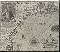
Map of New England by John Smith, published in 1616.
.jpg)
See also
 In Spanish: Plymouth (Massachusetts) para niños
