
Rollins Pass facts for kids
Quick facts for kids Rollins Pass |
|
|---|---|
| Boulder Pass, Corona Pass, Rollinsville Pass | |
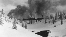
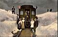
The Riflesight Notch trestle on Rollins Pass
|
|
| Elevation | 11,676.79 ft (3,559 m) |
| Traversed by |
|
| Location | Boulder, Gilpin, and Grand counties, Colorado, U.S. |
| Range | Front Range |
| Coordinates | 39°56′03″N 105°40′58″W / 39.93417°N 105.68278°W |
| Topo map | USGS East Portal |

Rollins Pass
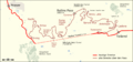
Location in Colorado
|
|
|
Rollinsville and Middle Park Wagon Road / Denver, Northwestern and Pacific Railway Hill Route Historic District
|
|
| Area | 436.3 acres (176.6 ha) |
| Built | 1873 |
| Built by | Rollins, John Q.A. |
| NRHP reference No. | 80000881, 97001114 |
| Added to NRHP | Tuesday, September 30, 1980 |
Rollins Pass is a mountain pass in north-central Colorado, United States. It sits high in the Southern Rocky Mountains at an elevation of 11,676.79 ft (3,559.09 m). This area is also an active archaeological site, meaning scientists are still studying its past.
The pass crosses the Continental Divide of the Americas, which is like a giant line that separates rivers flowing to the Atlantic Ocean from those flowing to the Pacific Ocean. Rollins Pass is located southwest of Boulder and near Winter Park and Rollinsville. It touches the edges of Boulder, Gilpin, and Grand counties.
For over 10,000 years, Rollins Pass has been a path across the Continental Divide. It connected the South Platte River basin, which flows to the Atlantic, with the Fraser River, which flows into the Colorado River and then to the Pacific.
The old railroad route over Rollins Pass was added to the National Register of Historic Places in 1980. This was because of important events and amazing engineering achievements from the early 1900s. Later, in 1997, more areas were added to recognize the work of John Q.A. Rollins and his toll wagon road. In 2012, Rollins Pass was even listed as one of Colorado's most endangered historic sites.

Contents
- About Rollins Pass
- History of Rollins Pass
- Artifacts and Features
- Environment of Rollins Pass
- Climate of Rollins Pass
- Accessing Rollins Pass
- Airspace and Aviation
- Places and Landmarks
- Images for kids
About Rollins Pass
Naming the Pass
The official name for this mountain crossing is Rollins Pass. The United States Geological Survey and the United States Board on Geographic Names made this decision in 1904. Before that, it was sometimes called Boulder Pass or Rogers Pass. It was also occasionally known as Rollinsville Pass.
In Grand County, some people call it Corona Pass. This name comes from Corona, a station that used to be at the very top of the pass. However, many old railroad workers didn't like this name. They felt it was wrong to name a mountain pass after a station.
How High is Rollins Pass?
The exact height of Rollins Pass is 11,676.79 ft (3,559.09 m). This measurement comes from a detailed survey done in 1952. It's important to have precise measurements for places like this.
What is Rollins Pass Like?
Rollins Pass has been used for thousands of years.
- Over 10,000 years ago, Paleoindians and Native Americans used it for hunting.
- From 1862 to 1880, it was a wagon road.
- From 1880 to 1928, it was a railroad route.
- From 1936 to 1956, it was a simple car road.
- Since 1956, it has been a road for motor vehicles.
Today, the pass is used by hikers on trails like the Continental Divide Trail. It also has an airway for planes and a large natural gas pipeline. There are two main dirt roads:
- The first is the Rollinsville and Middle Park Wagon Road, built in the 1860s. This old wagon route, now called the Boulder Wagon Road, goes steeply up Guinn Mountain. It circles Yankee Doodle Lake and then heads west into the Middle Park valley.
- The second road is mostly the old path of the Denver, Northwestern, and Pacific Railway. This high-altitude railroad was part of the Moffat Road. It was replaced by the Moffat Tunnel in 1928. The train tracks were removed in 1936, but you can still see some old rail pieces and wooden ties.
Geology of the Pass
The mountains around Rollins Pass, part of the Front Range, were formed by a process called the Laramide Orogeny. This happened between 70 and 40 million years ago. It was a time when the Earth's plates moved, pushing up the land to create the Rocky Mountains we see today.
History of Rollins Pass

Ancient Hunting Grounds
Long ago, Paleoindians and early Native Americans were the first to use Rollins Pass. They used it as a natural, lower way to cross the Continental Divide. They hunted large animals like bighorn sheep and elk.
There are over 96 documented game drives on the pass. These are handmade rock walls and blinds, mostly found above the tree line. Hunters would use these walls to guide animals towards them. These amazing structures were built and used for thousands of years. Today, students from Colorado State University are studying these important sites.
The Olson Game Drive
The Olson site is a large game drive system on Rollins Pass. It includes at least 45 blinds and over 1,300 meters of rock walls. These were used to funnel animals uphill to waiting hunters. Scientists have used special dating methods to show that Native Americans used this site for at least 3,200 years. Some tools found suggest it was used even earlier, over 10,000 years ago.
Native American Travel Route
Rollins Pass was also a path for Native Americans to travel, hunt, and even for battles.
The Indians, both Ute and Arapahoe, used Rollins Pass. While it is possible to ride a horse across the Range at almost any point except some of the higher and rougher peaks, the Indians were as much interested as the white man in seeking a good grade. Instead of wagons they used teepee poles as drag-poles for transportation of supplies and papooses, and it was necessary that they follow easy grades and broad level country, wherever practical.
—Edgar McMechen, Romantic History of Rollins Pass, Municipal Facts
This quote explains that Native Americans, like the Ute and Arapahoe tribes, preferred easier paths. They used poles as drag-poles to carry their belongings and babies.
The Historic Wagon Road
The first recorded use of the pass by a wagon train was in 1862. This was 14 years before Colorado became a state. John Quincy Adams Rollins, an early Colorado pioneer, built a toll wagon road over the pass in 1873. This road connected the Colorado Front Range with Middle Park. Rollins Pass was later named after him.
John Quincy Adams Rollins
John Q.A. Rollins was born in New Hampshire in 1816. He was known as a strong and popular man. He died in 1894 and is buried in Colorado's oldest cemetery. His tombstone simply says, "John Q.A. Rollins | Colorado Pioneer of Rollinsville and Rollins Pass."
Building the Wagon Road

John Rollins got approval for his toll wagon road in 1866. The Colorado Territory government approved it as the "Middle Park and South Boulder Wagon Road Company." The road was finished in August 1873. Some newspapers said it was easy to cross, but others called it "fearful for wagons" due to rocks and mud.
In 1874, James Harvey Crawford and his wife, Margaret, were the first non-Native American couple to cross Rollins Pass by wagon. Mrs. Crawford was the first woman to do so. She described the journey as very bumpy, with the wagon "almost standing on end."
The pass was heavily used in the late 1800s by settlers. At one point, as many as 12,000 cattle were driven over the pass. The wagon road had a tollgate where people paid to cross. For example, a vehicle with two animals cost $2.50.
John Rollins also built log structures called "cribbing" to help reduce the steepness of the road. You can still see some of this original log cribbing on Guinn Mountain today. He also built The Junction House, a large hotel for travelers. The wagon road started to be used less and fell apart around 1880.
The Historic Railroad Route
Early Railroad Attempts
Many attempts were made to build a railroad over Rollins Pass in the 1800s. But all of them failed due to tough engineering problems or money issues. One attempt in the 1880s left behind a tunnel that you can still see near Yankee Doodle Lake.
The Moffat Road
In the early 1900s, a banker named David Moffat started the Denver, Northwestern and Pacific Railway. He wanted to build a railroad from Denver to Salt Lake City, Utah. The plan was to go through a tunnel under the Continental Divide. Construction started in 1903. This entire line was known as the Moffat Road.
The Moffat Road included a 23-mile section over Rollins Pass. It had steep grades and switchbacks, making it one of the highest standard-gauge railroads in North America. This route was meant to be temporary until the Moffat Tunnel could be built. So, it used cheaper materials like wooden trestles instead of iron bridges. Building this route was very dangerous. For example, 60 workers died when an explosion happened in Needle's Eye Tunnel.
The route had three tunnels: Tunnel #31, Tunnel #32 (Needle's Eye Tunnel), and Tunnel #33 (the Loop Tunnel). Today, all three tunnels are either completely caved in or partly collapsed. Another famous spot was the Riflesight Notch Loop. Here, trains crossed a trestle, went down 150 feet, and then passed through Tunnel #33 underneath the trestle.
A train station called Corona was built at the summit. It had a dining hall, weather station, and lodging. In summer, people could take a train from Denver to Corona and stand in snowdrifts in July or August.
Weather Challenges for the Railroad

The railroad line near the summit was covered by almost continuous snowsheds (wooden tunnels). But even with these, trains often got stuck for days, or even months, during heavy snowstorms. Snow could blow through the wooden sheds. These delays affected mail delivery. Also, coal smoke and toxic gases built up in the snowsheds. This caused temporary blindness, loss of consciousness, and sometimes even death for workers. The workers had a saying: "There's winter and then there's August," meaning the weather was always tough. These severe snowstorms eventually led to the financial failure of the Moffat Road. This pushed for the building of a permanent tunnel through the mountains.
Many train accidents happened on Rollins Pass. These included derailments, runaway trains, and collisions. Avalanches also caused serious problems, sweeping trains off the tracks. Despite these dangers, by 1918, the railroad had many engines and snowplows to keep things moving.
The Moffat Tunnel

Plans for a longer tunnel at a lower elevation were made. The single-track Moffat Tunnel opened south of Rollins Pass on February 26, 1928. This tunnel made the old Rollins Pass route unnecessary. It removed 10,800 degrees of curves from the journey. This saved a lot of time and money that was used for snow removal on Rollins Pass. After the tunnel opened, the railroad saved a lot of money on fuel and engine servicing.
The tracks over Rollins Pass were kept as an emergency route until July 1929. They were used only once when the Moffat Tunnel was blocked by a rockfall. Permission to remove the rails on Rollins Pass was given in 1935. The rails and ties were removed in the summer of 1936.
The Moffat Tunnel route became the main line across Colorado. Today, it is used by Amtrak's California Zephyr and the Winter Park Express ski train. The original law for the Moffat Tunnel also said it should be used for cars on flatbed railcars, but this never happened. The tunnel's original construction tunnel was later turned into the Moffat Water Tunnel for Denver Water.
Rollins Pass as an Air Route
In the 1940s, Rollins Pass became part of an air route. An airway radial, Victor Eight, crosses the pass. A rotating airway beacon was also set up on Beacon Peak. This beacon helped pilots navigate. It was removed in the late 1960s when new radio navigation systems were introduced.
Rollins Pass as an Automobile Road
Plans to turn Rollins Pass into a car road were made in 1949. On September 1, 1956, Rollins Pass opened as a seasonal recreational road. It was a complete road over the mountain until 1979, when a large rockfall in Needle's Eye Tunnel closed the path. The road reopened in 1989 after repairs, but closed permanently in 1990. This was because a rockfall injured a sightseer. Since July 1990, no motorized route crosses the Continental Divide here. Each side is a dead-end road.
Rollins Pass and Natural Gas
In 1969, a natural gas pipeline was laid on Rollins Pass. In the mid-1990s, the pass was closed for the installation of a 10-inch Xcel Energy high-pressure natural gas pipeline. This pipeline still exists and uses the low pass to reach the Front Range. It follows much of the old railbed.
Artifacts and Features
Protecting History
Most of Rollins Pass is on federal land within the Roosevelt National Forest and Arapaho National Forest. Laws like the Archaeological Resources Protection Act of 1979 protect cultural resources here. It is illegal to collect artifacts like arrowheads, horseshoes, old cans, or railroad spikes from Rollins Pass. These items are part of history and are being studied by universities and government groups.
When artifacts are removed, we lose clues about the past. Every artifact has scientific and cultural value. Theft harms the historical record. Visitors are asked to leave items where they are and share photos and GPS coordinates with researchers.
Old Structures and Towns
There are several ghost towns and old settlements on or near Rollins Pass. Some of the most well-known are Arrow, Corona, Ladora, and Tolland. These places date back to the wagon road and railroad eras.
There are also several historic gravesites. One headstone at Arrow reads, "R.M. Smith | June 28, 1842 | Nov. 12, 1909."
Environment of Rollins Pass


Leave No Trace Principles
Rollins Pass has unique plants, animals, and water areas. To protect this environment, all visitors should follow leave no trace principles. This means staying on trails and not disturbing anything. Moving rocks or artifacts is also discouraged.
Plants of Rollins Pass
Rollins Pass has different plant environments. At lower elevations, you'll find lodgepole pine and aspen trees. Near the tree line, there are twisted, stunted trees called krummholz. Above the tree line, the landscape is mostly small perennial wildflowers, cryptobiotic soils, and alpine tundra. The alpine tundra is very fragile. If it's damaged, it can take 100 to 500 years to recover. Staying on the road prevents damage like erosion and habitat destruction. There are areas on Rollins Pass where plants are being regrown, like at Yankee Doodle Lake.
Pine Beetle Epidemic
The mountain pine beetle epidemic, which started in 1996, affects many forests in Colorado, including Rollins Pass. These beetles kill trees, making them dry and more likely to catch fire.
Animals of Rollins Pass
The main predator in the area is the black bear, usually found below the tree line. Bears hunt bighorn sheep, mountain goats, and yellow-bellied marmots. Above the tree line, you might see pikas. Elk and mule deer are common at or below the tree line. Native Americans built game drives here because of these large animals.
Porcupines can be seen at all elevations on Rollins Pass, even at the summit. They are active at night and are good tree climbers.
Among birds, the white-tailed ptarmigan lives on Rollins Pass, especially above the tree line. Their feathers change color to help them blend in with their surroundings. Other birds like Brown-capped rosy finches and rock wrens are also found here.
Waterways and Lakes
Rollins Pass has rich ecosystems where water meets the alpine and subalpine tundras.
Lakes
There are three lakes on the west side: Deadman's Lake, Pumphouse Lake, and Corona Lake. On the east side are King Lake, Yankee Doodle Lake, and Jenny Lake. Yankee Doodle Lake was once called Lake Jennie.
In 2010, Pumphouse Lake and Ranch Creek were found to be polluted by the United States Environmental Protection Agency.
Creeks and Rivers
On the west side, you'll find the Fraser River and creeks like Ranch Creek. On the east side, the South Fork of the Middle Boulder Creek is fed by Bob and Betty Lakes. Jenny Creek is fed by Jenny and Yankee Doodle Lakes. The South Boulder Creek flows through Buttermilk Falls, a large waterfall visible from the pass.
Improvements to Water Areas
In 2006, the United States Forest Service worked with environmental groups to improve wetlands and lake areas at Yankee Doodle Lake and Jenny Creek. Fences were put up to keep vehicles on designated routes and protect damaged areas.
Wildfires
In summer, the risk of wildfires increases due to dry conditions, lightning, and human activities. Campfires that are not managed properly can also cause fires.
Fire Restrictions
Fire restrictions are often put in place on Rollins Pass, usually starting in mid-July or August. These rules help prevent wildfires. For example, in July 2020, parts of Rollins Pass had Stage 2 Fire Restrictions, which means very strict rules about fires.
| Boulder County | Gilpin County | Grand County |
|---|---|---|
| Stage 2 | Stage 2 | Stage 1 on USFS lands |
Causes of Wildfires
- Nature Caused: In 1996, a lightning strike caused a wooden trestle near the summit to catch fire. Fire crews put it out.
- Human or Equipment Caused:
- In 1915, a saloon owner set fire to his business in the town of Arrow, hoping to get insurance money. High winds spread the fire, destroying most of the town.
- In 1918, a fire started near the Corona station, fanned by 40 mph winds. It destroyed the power station, telegraph system, and several buildings.
- In 1923, a train caused a wildfire on the east side of Rollins Pass.
- In 1925, a passenger train was destroyed by fire in a snowshed.
- In 1927, the town of Rollinsville was almost destroyed by a fire likely caused by a spark from a train.
- In 1938, a human-caused fire near the Moffat Tunnel burned 800 acres.
- In 2010, a plane crash on the east side of the pass caused a small wildfire.
Climate of Rollins Pass


Seasons
Winter
Winters on Rollins Pass are very cold, with sudden blizzards, strong winds, and deep snow. Overnight trips require very warm gear. Spring-like conditions don't usually start until June. Wildflowers bloom from late June to early August.
Summer
Because the pass is high above the timberline, there is no protection from sudden thunderstorms. Being caught in an electrical storm can be very dangerous. A metal-topped vehicle is the safest place to be, as it acts like a Faraday cage.
Weather Records
Historical Records
During the railroad era, a United States Weather Bureau station was at Corona. Records show that the lowest temperature was −30 °F (−34 °C) in February 1910. The most snowfall in one month was 72.5 inches (184 cm) in March 1912. Winds could reach over 60 mph (97 km/h), and temperatures could drop to −44 °F (−42 °C).
Present Day Records
Today, a small, solar-powered weather station is located on the west side of Rollins Pass.
Atmospheric Pressure and Health
The air pressure at the summit is much lower than at sea level. This means there is less oxygen. Many people, especially those from lower elevations, can get altitude sickness. This can cause rapid dehydration. Altitude sickness can become very serious, leading to HAPE or HACE, which can be deadly. Historically, people suffered heart attacks and pneumonia at the summit.
Avalanches
Avalanches can happen anywhere on the pass, caused by humans or nature. There have been four notable avalanches on Rollins Pass.
Railroad Era Avalanches
- In January 1914, sliding snow from Tunnel #32 blocked the tracks for days near Yankee Doodle Lake.
- In December 1917, an avalanche near Yankee Doodle Lake swept a train and engine 150 feet off the tracks. Workers were injured and some died.
Post-Railroad Era Avalanches
Backcountry skiers and snowmobilers should always check avalanche forecasts. They should also carry and know how to use rescue gear.
- In November 2001, two experienced skiers triggered a large avalanche in the Yankee Doodle Lake basin. It fell 600 feet and crashed through the 10-inch thick ice of Yankee Doodle Lake. Both men were pushed into the lake. One survived but suffered hypothermia and frostbite. The other skier's body was found 91 feet offshore.
- In February 2021, a snowmobiler died in an avalanche on Mount Epworth near Pumphouse Lake.
Accessing Rollins Pass
General Information and Recreation

Rollins Pass is managed by the United States Forest Service for recreation. You can reach it from roads on both the west and east sides. However, no motorized route connects across the Continental Divide. The entire road is unpaved (dirt and rock), has no guardrails, and a speed limit of 20 mph (32 km/h). You should check current Motor Vehicle Use Maps (MVUMs) to see which roads are open. Driving in wilderness areas is forbidden, and fines can be up to $5,000. Fences are placed to show areas closed to vehicles.
There are no facilities like restrooms, shops, or water on the pass. The only exception is the Årestua Hut, a small hut on Guinn Mountain that is open year-round. There are also stone windbreaks built during the railroad era, which offer some shelter from the wind.
Winter Access
Both sides of the pass can be traveled by snowmobile in winter, usually from late November to early April, when there is at least six inches (15 cm) of snow.
Spring Closures
Both sides of the pass are closed in spring to all motorized vehicles. This includes several weeks in June. This closure prevents damage to the roads from melting snow and mud.
Summer and Early Autumn Access
Both sides of the pass can be traveled by motorized vehicles in summer and early autumn, if the weather is good. Rollins Pass is usually open for vehicles from June 15 to November 15. However, due to snow, it's often not possible to drive higher than Yankee Doodle Lake on the east side or Ptarmigan Point on the west side until mid-July. Early snowstorms in late September or October can close the higher parts of the road for the winter. On average, the road is only fully passable for less than 90 days a year.
The United States Forest Service says summer use of the pass is "heavy." Parking can be limited. The road mostly has gentle slopes with switchbacks. However, some sections are steep. four-wheel drive vehicles are better than two-wheel drive vehicles, especially in rougher areas. When two vehicles meet on a narrow section, the vehicle going downhill must yield to the one going uphill.
Continental Divide Trail Access
The Continental Divide Trail crosses the summit of Rollins Pass. Hikers can follow this trail through the Indian Peaks Wilderness.

Access from the East (near Rollinsville)
The road on the eastern side starts from Colorado State Highway 119 near Rollinsville. It runs parallel to South Boulder Creek and the current Union Pacific Railroad tracks. This part of the road is gravel and can be traveled by regular cars. However, once you reach the official start of Rollins Pass road (Forest Service Road 117), it becomes very rough. It has many rocks and potholes that are several feet wide. This road is only suitable for "high-clearance vehicles," not regular passenger cars.
This old railroad bed is open for 11.7 miles (18.8 km). About half a mile before Needle's Eye Tunnel, there is a gate that blocks motorized vehicles. You can still hike or mountain bike beyond the tunnel toward the summit. No motorized route crosses the Continental Divide.
Much of the lower eastern side of the pass is private property. Please do not trespass off the road.
Access from the West (near Winter Park)
The road on the western side (County Road 80) starts from U.S. Highway 40 in Winter Park. This road also has many rocks and potholes. It is only suitable for "high-clearance vehicles."
This road is open for 14.4 miles (23.2 km) and ends at the summit's parking area. Just before the summit, you can turn right onto another rough road (Forest Service Road 501.1). This road goes above the summit for another 1.8 miles (2.9 km) and ends near Yankee Doodle Lake. No motorized route connects across the Continental Divide.
The lower part of the western side is owned by the Arapaho and Roosevelt National Forest. Further up, some land belongs to private companies and Denver Water. After the ghost town of Arrow, the land becomes National Forest again up to the summit.
Guided Tours
- Winter: Guided snowmobile tours follow the summer road from Arrow. They go up to Ptarmigan Point, which is almost 12,000 feet high, but they do not reach the very summit.
- Summer: Guided off-road tours are also offered on the west side. These tours use off-road vehicles but stay on the designated roads. Off-roading is strictly forbidden.
Trails and Closures
The entire pass is open for snowshoeing, fatbiking, backcountry skiing, and cross-country skiing in winter. In summer, it's open to hikers, bicyclists, and horseback riders. As mentioned, no motorized route crosses the Continental Divide.

Historic Wagon Route
If you want to follow the old wagon route by vehicle, there are many closures. No motorized route crosses the Continental Divide.
- Near Rollinsville, the Jenny Creek motorized trail follows part of the wagon road.
- The wagon road becomes Forest Service Road 501 at Yankee Doodle Lake. This part is permanently closed to all motorized vehicles. It has steep switchbacks and is within the Indian Peaks Wilderness.
- The wagon route can only be followed on foot into Middle Park.
Railroad Line
Most of the old railroad line is open and intact, but there are exceptions. No motorized route crosses the Continental Divide.
- Some wooden railroad trestles have fallen apart or been removed. All existing trestles are closed to motorized traffic.
- Two railroad tunnels on Rollins Pass are completely caved in: Tunnel #31 and Tunnel #33.
- Tunnel #32, Needle's Eye Tunnel, is also closed. This 170-foot long tunnel was built in 1903. It was open to cars from 1956 to 1979. After rockfalls, it was repaired and reopened in 1989. However, in July 1990, a large rockfall injured a sightseer, causing the tunnel to close permanently. Since then, more rockfalls have occurred.
Future of the Road
In 2002, a law was passed that said if the counties of Grand, Gilpin, and Boulder asked, the Rollins Pass road could be repaired enough for regular cars to cross. Historically, Gilpin and Grand counties wanted to reopen the road, but Gilpin County has now changed its mind and opposes it, along with Boulder County.
Only minor repairs have been made to the road. It is difficult and expensive to make big improvements. Also, there are ongoing disagreements about the 1990 tunnel accident. Because of these issues, the road has not been fully reopened.
Airspace and Aviation

Airspace
Rollins Pass is in Class G airspace. This means air traffic control doesn't directly control planes here. However, pilots still need to follow rules for flying safely.
Airway Victor Eight
The airway Victor Eight crosses Rollins Pass. Pilots are advised to avoid this area in bad weather. This is because of strong downdrafts, mountain waves, and turbulence on the east side of the pass.
Drone Operations
Drone flights are allowed over Rollins Pass if they follow FAA rules. However, drones cannot take off or land in federally protected wilderness areas. Drone pilots should be careful because other aircraft, like Flight for Life helicopters and search and rescue helicopters, fly in the area.
Emergency Landing Zone
An emergency helicopter landing zone was created at the summit of Rollins Pass between 1999 and 2005. It is not lit at night.
Old Airway Light Beacon
A rotating airway light beacon, called Beacon 82, was placed near the summit of Rollins Pass in the 1940s. It was about 12,080 feet (3,680 m) high. This beacon helped mark the airway between Los Angeles and Denver. It was removed in the late 1960s. Its concrete foundation and metal leg stubs can still be seen. The beacon itself is stored at a museum in Hot Sulphur Springs, Colorado.
Places and Landmarks
- Many ski runs and a chairlift at Winter Park Resort are named after Rollins Pass features. Examples include Rollins Ridge, Corona Way, Riflesight Notch, and Needle's Eye. Other names are inspired by railroad terms like Trestle, Sleeper, and Zephyr.
- Winter Park Resort's summer mountain bike park is called Trestle.
- Some buildings at Winter Park Resort are also named after Rollins Pass features, like Mount Epworth.
- Two ski runs and a chairlift at Eldora Mountain Resort are named Corona and Corona Road, and the Corona Lift.
- A real estate development in Winter Park is named after the ghost town of Arrow on Rollins Pass.
Recreation and Events
- The Epworth Cup is a long-running downhill skiing race held every July on Mount Epworth.
- The Indian Peaks Traverse, a 60-mile trail for hikers, bicyclists, and horseback riders, will cross a part of Rollins Pass. It is expected to open around 2022.
- In 2020, the five remaining East Portal Camp Cabins near Rollins Pass were listed as one of Colorado's Most Endangered Places.
Science and Archaeology
- In 2016, the United States Forest Service held a project on Rollins Pass. Volunteers helped with an archaeological survey along the old Moffat Road.
Images for kids
-

The Riflesight Notch trestle on Rollins Pass
-
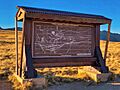
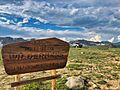
The sign at the summit of Rollins Pass displays four proposed rail tunnel routes through the Continental Divide as alternatives to summiting Rollins Pass; it was the longer Moffat Tunnel that achieved this feat of engineering and was first utilized in February 1928.
-
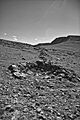
A low rock wall and attached hunting blind (pit) at the Olson Game Drive on Rollins Pass. These features were hand-made by Native Americans; radiocarbon and lichenometric dating suggest occupation by Native Americans spanning the last 3,200 years, with diagnostic tools suggesting even older use of the site to more than 10,000 years ago.
-
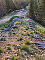
Original log cribbing on Rollins Pass, laid by John Q.A. Rollins, to aid with the passage of wagons in this area along Guinn Mountain. This view is looking due east; out of frame and directly below at right, is Yankee Doodle Lake.
-
"Snow cuts on Rollin's [sic] Pass, Moffat Road, Colo." This is a colorized sketch of McClure photograph 257-8067, the description stating, "Snow scene, summit Rollin's Pass: elevation, 11,660 feet; on Moffat Line R. R., three hours' ride from Denver. Photograph taken in May, 1906. The region of perpetual snow. Photograph by L.C. McClure, Denver."
-
The winding inefficiency of the outdoor Rollins Pass rail route is brought into sharp contrast when compared with the direct, weather-agnostic Moffat Tunnel route. The Moffat Tunnel eliminated 10,800 degrees of curvature along the Rollins Pass route.
-
Illegal off-roading of a vehicle on Rollins Pass near Mount Epworth and Deadman's Lake. The alpine tundra is extremely fragile and can take 100–500 years to fully recover.
-
This annotated view shows the damage to the alpine tundra caused by illegal offroading on Rollins Pass. The vehicle is outlined in blue, the tire tracks in red, and the designated road in yellow.
-
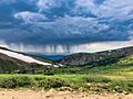
Summer thunderstorms form very quickly; above timberline, exposure to electrical storms can be dangerous or deadly. This weather system was photographed on Sunday, July 8, 2018 on the west side of the Rollins Pass road, roughly halfway between the trailhead for Pumphouse Lake and the summit.
-
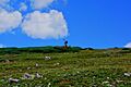
A small, solar-powered weather station is surrounded by native growth on the west side of Rollins Pass, located above Ptarmigan Point.
-
A vehicle has not followed the published Motor Vehicle Use Maps (MVUMs) and has parked inside of the Indian Peaks Wilderness area, where motorized vehicles are prohibited. Fines can be as much as $5,000.
-
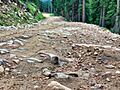
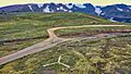
Typical summer condition of the road on Rollins Pass. This photograph was taken facing southwest on the road near the Riflesight Notch trestle on the west side of Rollins Pass.
-
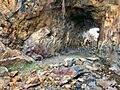
2018 photograph of Needle's Eye Tunnel, near the summit of Rollins Pass. This view shows the northeast portal in the foreground; the southwest portal can be seen in the background. Wire mesh and metal dowels were installed in August 1987 to help reduce additional rock falls and preserve the condition of the tunnel constructed in 1903 .
-
An aerial view of the emergency backcountry helicopter landing zone located at the summit of Rollins Pass; the white prong of the landing zone, furthest from the camera, points north. The comparatively low saddle of Rollins Pass is visible in this image as the summit itself (in the foreground and midground) is plainly lower in elevation than the surrounding mountains. The wood debris consists of both remnants from snowsheds that covered the tracks as well as discarded railroad ties that were removed from service in the summer of 1936.
