Shelby County, Tennessee facts for kids
Quick facts for kids
Shelby County
|
|||
|---|---|---|---|

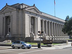
Shelby County Courthouse
|
|||
|
|||

Location within the U.S. state of Tennessee
|
|||
 Tennessee's location within the U.S. |
|||
| Country | |||
| State | |||
| Founded | November 24, 1819 | ||
| Named for | Isaac Shelby | ||
| Seat | Memphis | ||
| Largest city | Memphis | ||
| Area | |||
| • Total | 785 sq mi (2,030 km2) | ||
| • Land | 763 sq mi (1,980 km2) | ||
| • Water | 22 sq mi (60 km2) 2.8%% | ||
| Population
(2020)
|
|||
| • Total | 929,744 | ||
| • Estimate
(2023)
|
910,042 |
||
| • Density | 1,184.4/sq mi (457.29/km2) | ||
| Time zone | UTC−6 (Central) | ||
| • Summer (DST) | UTC−5 (CDT) | ||
| Congressional districts | 8th, 9th | ||
Shelby County is located in the western part of Tennessee, a state in the United States. It is the westernmost county in Tennessee. In 2020, about 929,744 people lived here. This makes it the largest county in Tennessee, both by how many people live there and by its size.
The main city and county seat is Memphis. Memphis is a busy port city on the Mississippi River. It is also the second-largest city in Tennessee. The county got its name from Isaac Shelby (1750–1826), who was a governor of Kentucky. Shelby County is one of only two counties in Tennessee where most people are African American. It is part of the larger Memphis metropolitan area. The Mississippi River forms its western border.
Long ago, this area was known for its large cotton farms. Cotton was a very important crop here for many years. Today, the economy of Shelby County has many different types of businesses.
Contents
History of Shelby County
The land along the Mississippi River was home to many different groups of indigenous peoples for a long time. In more recent history, the Chickasaw people lived in much of this area. They are thought to be related to the ancient Mississippian culture. This culture built large, complex cities with strong defenses. One of the biggest was Cahokia, which was active from around 950 CE until the 1400s. It was located on the east side of the Mississippi River, in what is now southern Illinois.
The United States government gained the Shelby County area from the Chickasaw people in 1818. This was part of a deal called the Jackson Purchase. Shelby County was officially created in 1819 by European-American settlers. It was named after Isaac Shelby, who helped with the land deal.
From 1827 to 1868, the county seat was in a town called Raleigh, Tennessee. Raleigh is now part of Memphis. After the American Civil War, Memphis grew a lot and became very important. So, the county seat was moved there.
Before the Civil War, the lowlands near the Mississippi River were used for big cotton farms. Most of the workers on these farms were enslaved African Americans. They were brought from other parts of the country. Even before the Civil War, most people in the county were Black, and most of them were enslaved. Memphis became a major place for trading cotton.
After the war, enslaved people became free. Many freedmen (newly freed people) stayed and worked on the land as sharecroppers. This meant they farmed the land and shared the crops with the landowner.
After the Civil War, politics in Tennessee were very competitive. People in eastern Tennessee often supported the Republican Party. Black people in western Tennessee also supported the Republican Party. Most white people who wanted to keep things as they were supported the Democratic Party.
From 1877 to 1950, there were many unfair acts of violence against Black people in Shelby County. This was the highest number in the state. Around the early 1900s, laws were passed that made it very hard for Black people to vote. The state also passed Jim Crow laws. These laws made public places separate for Black and white people. Black people were mostly kept out of the political system for over 60 years.
In the 1900s, new machines made farming easier, so fewer farm workers were needed. At the same time, factories and railroads in the North were looking for workers. This led to the Great Migration. Many African Americans moved from rural areas to Memphis or to cities in the North. They were looking for jobs and better social and political opportunities.
After World War II, new highways were built. This led to many new homes being built outside Memphis, where land was cheaper. People started moving from the city to the suburbs. Businesses followed them. As more homes and suburbs grew, the population of the wider Memphis area became mostly white.
Today, Shelby County has six towns that have their own local governments. Other areas are not part of any town. People in the county enjoy many parks and attractions in Memphis.
Geography of Shelby County
Shelby County covers about 785 square miles. About 763 square miles is land, and 22 square miles (2.8%) is water. It is the largest county in Tennessee by land area. The lowest point in Tennessee is in Shelby County. It is on the Mississippi River, where the river leaves Tennessee and flows into Mississippi.
Rivers in Shelby County
Neighboring Counties
- Tipton County (north)
- Fayette County (east)
- Marshall County, Mississippi (southeast)
- DeSoto County, Mississippi (south)
- Crittenden County, Arkansas (west)
People of Shelby County
| Historical population | |||
|---|---|---|---|
| Census | Pop. | %± | |
| 1820 | 364 | — | |
| 1830 | 5,648 | 1,451.6% | |
| 1840 | 14,721 | 160.6% | |
| 1850 | 31,157 | 111.7% | |
| 1860 | 48,092 | 54.4% | |
| 1870 | 76,378 | 58.8% | |
| 1880 | 78,430 | 2.7% | |
| 1890 | 112,740 | 43.7% | |
| 1900 | 153,557 | 36.2% | |
| 1910 | 191,439 | 24.7% | |
| 1920 | 223,216 | 16.6% | |
| 1930 | 306,482 | 37.3% | |
| 1940 | 358,250 | 16.9% | |
| 1950 | 482,393 | 34.7% | |
| 1960 | 627,019 | 30.0% | |
| 1970 | 722,014 | 15.2% | |
| 1980 | 777,113 | 7.6% | |
| 1990 | 826,330 | 6.3% | |
| 2000 | 897,472 | 8.6% | |
| 2010 | 927,644 | 3.4% | |
| 2020 | 929,744 | 0.2% | |
| 2023 (est.) | 910,042 | −1.9% | |
| U.S. Decennial Census 1790-1960 1900-1990 1990-2000 2010-2014 |
|||
| Race / Ethnicity (NH = Non-Hispanic) | Pop 2000 | Pop 2010 | Pop 2020 | % 2000 | % 2010 | % 2020 |
|---|---|---|---|---|---|---|
| White alone (NH) | 414,888 | 359,106 | 316,740 | 46.23% | 38.71% | 34.07% |
| Black or African American alone (NH) | 434,201 | 481,434 | 475,074 | 48.38% | 51.90% | 51.10% |
| Native American or Alaska Native alone (NH) | 1,538 | 1,804 | 1,561 | 0.17% | 0.19% | 0.17% |
| Asian alone (NH) | 14,552 | 21,245 | 27,960 | 1.62% | 2.29% | 3.01% |
| Pacific Islander alone (NH) | 248 | 274 | 256 | 0.03% | 0.03% | 0.03% |
| Other race alone (NH) | 946 | 1,097 | 3,614 | 0.11% | 0.12% | 0.39% |
| Mixed race or Multiracial (NH) | 7,735 | 10,595 | 26,832 | 0.86% | 1.14% | 2.89% |
| Hispanic or Latino (any race) | 23,364 | 52,092 | 77,707 | 2.60% | 5.62% | 8.36% |
| Total | 897,472 | 927,644 | 929,744 | 100.00% | 100.00% | 100.00% |
2020 Census Information
In 2020, the United States census counted 929,744 people living in Shelby County. There were 353,950 households and 215,446 families.
2010 Census Information
According to the 2010 United States Census, there were 927,644 people in the county.
- 52.1% were Black or African American.
- 40.6% were White.
- 2.3% were Asian.
- 0.2% were Native American.
- 3.3% were of some other race.
- 1.4% were of two or more races.
- 5.6% were Hispanic or Latino (this group can be of any race).
Education in Shelby County
Colleges and Universities
Shelby County has many places for higher education. These include colleges and university campuses.
In Memphis, you can find:
- Baptist College of Health Sciences
- Christian Brothers University
- Embry–Riddle Aeronautical University, Worldwide (Memphis Campus)
- Harding School of Theology
- LeMoyne–Owen College
- Memphis College of Art
- Memphis Theological Seminary
- Rhodes College
- Southern College of Optometry
- Southwest Tennessee Community College
- University of Tennessee Health Science Center
- University of Memphis
In Cordova, there is Mid-America Baptist Theological Seminary. Germantown has a campus of Union University.
Schools for Kids (K-12)
Shelby County Schools (SCS) is the main school district. It serves all of Memphis and most areas outside the city.
Some towns in the county have their own school districts:
- Arlington Community Schools
- Bartlett City Schools
- Collierville Schools
- Germantown Municipal Schools
- Lakeland School System
- Millington Municipal Schools
Before 2013, there were two main school districts: Shelby County Schools (for areas outside Memphis) and Memphis City Schools (for Memphis). On June 30, 2013, these two districts joined together. They formed one big school system called Shelby County Schools. This unified system lasted for one year.
In 2014, six towns (Arlington, Bartlett, Collierville, Germantown, Lakeland, and Millington) decided to create their own school districts. Their residents had voted to do this. These new municipal districts started classes on August 4, 2014.
Getting Around Shelby County
Local Travel
The Memphis Area Transit Authority (MATA) provides public transportation. MATA operates buses and the MATA Trolley. There is also a special suspended monorail called the Memphis Suspension Railway. It connects the city to Mud Island.
Travel Between Cities
You can travel to and from Shelby County using:
- Amtrak (the City of New Orleans train)
- Delta Bus Lines
- Flixbus
- Greyhound Lines
- Jefferson Lines
- Megabus
Main Roads
Airports
Memphis International Airport is located in Shelby County. It is about 3 miles south of downtown Memphis.
Fun Things to Do in Shelby County
Parks and Nature Areas
- Eagle Lake Refuge
- T. O. Fuller State Park
- Lichterman Nature Center
- Meeman-Shelby Forest State Park
- Memphis Parks and Recreation Centers
- Overton Park
- Piperton Wetland Complex (part)
- President's Island Wildlife Management Area
- Shelby Farms
Cool Places to Visit
- Beale Street, downtown Memphis
- Chucalissa Indian Village, an old Native American site
- Gibson Guitar factory tour
- Graceland, the former home of Elvis Presley
- Indie Memphis, a film festival
- Memphis Botanic Garden
- Memphis in May, a month-long festival
- Memphis International Raceway
- Memphis Zoo
- Mud Island, Memphis
- National Civil Rights Museum, Memphis
- Orpheum Theatre, Memphis
- Pink Palace Museum and Planetarium, Memphis
Sports Teams
- Memphis Grizzlies, an NBA basketball team
- Memphis Redbirds, a Triple-A minor league baseball team
- Memphis 901 FC, a USL Championship League soccer team (started in 2018)
- Memphis Showboats, a USFL football team
Towns and Communities
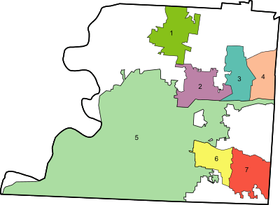
The numbers below match the map on the right.
Cities
- Bartlett – 2
- Germantown – 6
- Lakeland – 3
- Memphis (county seat) – 5
- Millington – 1
Towns
- Arlington – 4
- Collierville – 7
Other Communities (Unincorporated)
These areas are not part of a city or town government.
- Barretville
- Benjestown
- Brunswick
- Cordova
- Eads
- Egypt
- Ellendale
- Fisherville
- Kerrville
- Lenow
- Northaven
- Rosemark
- Shelby Forest
- Whitehaven
Famous People from Shelby County
- James Mortimer Crews, a veteran of the American Civil War.
- Country singer Bobbie Gentry has lived here privately since 2010.
- Yo Gotti, an American hip-hop artist.
- 8ball & MJG, American hip-hop artists.
- Young Dolph, an American hip-hop artist.
- Three 6 Mafia, a hip-hop group that won a Grammy award.
See also
 In Spanish: Condado de Shelby (Tennessee) para niños


