Allegany County, New York facts for kids
Quick facts for kids
Allegany County
|
|||
|---|---|---|---|

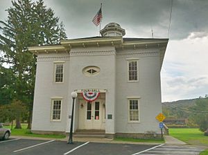
Old Allegany County Courthouse
|
|||
|
|||

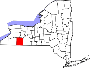
Location within the U.S. state of New York
|
|||
 New York's location within the U.S. |
|||
| Country | |||
| State | |||
| Founded | 1806 | ||
| Named for | Lenape name for the Allegheny River | ||
| Seat | Belmont | ||
| Largest town | Wellsville | ||
| Area | |||
| • Total | 1,034 sq mi (2,680 km2) | ||
| • Land | 1,029 sq mi (2,670 km2) | ||
| • Water | 5.1 sq mi (13 km2) 0.5% | ||
| Population
(2020)
|
|||
| • Total | 46,456 |
||
| • Density | 45.1/sq mi (17.4/km2) | ||
| Time zone | UTC−5 (Eastern) | ||
| • Summer (DST) | UTC−4 (EDT) | ||
| Congressional district | 23rd | ||
Allegany County is a county in the U.S. state of New York. In 2020, about 46,456 people lived there. Its main town, or county seat, is Belmont.
The county's name comes from a Lenape word. This word was used by early settlers for a trail that followed the Allegheny River. Allegany County is part of the Western New York area.
The Genesee River flows right through the middle of the county. It goes north towards Lake Ontario. In the mid-1800s, the Genesee Valley Canal was built. This canal helped connect southern markets to the Great Lakes and Mohawk River. Later, railroads became more important for moving goods. Part of the Oil Springs Reservation, which belongs to the Seneca Nation, is also in the county.
Contents
History of Allegany County
For many centuries, the Seneca people lived in the area that is now Allegany County. They were part of the Haudenosaunee (Iroquois) confederacy. European-American settlers did not move here permanently until after the American Revolutionary War. The Seneca people had to give up most of their land in western New York. New York State then sold this land cheaply. This helped attract new settlers and farmers.
Allegany County was officially created on April 7, 1806. It was formed from a part of Genesee County, New York. The first county seat was in Angelica, New York. It stayed there for about 50 years. Later, the county seat moved to Belmont. Belmont is a village along the Genesee River. Over time, the county's borders changed a few times as new counties were formed nearby.
Geography of Allegany County
Allegany County is in the southwestern part of New York State. It is right along the border with Pennsylvania. The county covers about 1,034 square miles. Most of this area is land, with a small part being water.
The highest point in the county is Alma Hill. It is about 2,548 feet above sea level. This is the highest point in New York State west of the Catskill Mountains. The Genesee River flows through the county from south to north. It eventually reaches Lake Ontario. Water from different parts of the county flows into three major river systems in North America.
In June 1972, a big storm called Hurricane Agnes caused heavy rain. More than 20 inches of rain fell. This led to major flooding in towns like Wellsville, Belmont, and Belfast.
The Genesee River has always been important for travel. Today, it is popular for canoeing. Many people also enjoy fishing in the river. It has lots of smallmouth bass, trout, and panfish.
Neighboring Counties
- Livingston County – northeast
- Steuben County – east
- Potter County, Pennsylvania – southeast
- McKean County, Pennsylvania – southwest
- Cattaraugus County – west
- Wyoming County – northwest
Main Roads
 Interstate 86 (Southern Tier Expressway)
 New York State Route 17 (Southern Tier Expressway)
 New York State Route 19
 New York State Route 21
 New York State Route 305
 New York State Route 417
People in Allegany County (Demographics)
| Historical population | |||
|---|---|---|---|
| Census | Pop. | %± | |
| 1810 | 1,942 | — | |
| 1820 | 9,330 | 380.4% | |
| 1830 | 26,276 | 181.6% | |
| 1840 | 40,975 | 55.9% | |
| 1850 | 37,808 | −7.7% | |
| 1860 | 41,881 | 10.8% | |
| 1870 | 40,814 | −2.5% | |
| 1880 | 41,810 | 2.4% | |
| 1890 | 43,240 | 3.4% | |
| 1900 | 41,501 | −4.0% | |
| 1910 | 41,412 | −0.2% | |
| 1920 | 36,842 | −11.0% | |
| 1930 | 38,025 | 3.2% | |
| 1940 | 39,681 | 4.4% | |
| 1950 | 43,395 | 9.4% | |
| 1960 | 43,978 | 1.3% | |
| 1970 | 46,782 | 6.4% | |
| 1980 | 51,742 | 10.6% | |
| 1990 | 50,470 | −2.5% | |
| 2000 | 49,927 | −1.1% | |
| 2010 | 48,923 | −2.0% | |
| 2020 | 46,456 | −5.0% | |
| U.S. Decennial Census 1790-1960 1900-1990 1990-2000 2010-2020 |
|||
In 2020, the population of Allegany County was 46,456 people. Most people in the county are White. A smaller number are Black, Native American, or Asian. Some people are of Hispanic or Latino background.
In 2000, about 31.5% of households had children under 18 living with them. About 54% of households were married couples. The average household had about 2.5 people. The average family had about 3 people.
The median age in the county was 35 years old. This means half the people were younger than 35, and half were older. About 24.4% of the population was under 18. About 14% of the population was 65 or older.
2020 Census Details
| Race | Number of People | Percentage |
|---|---|---|
| White (Not Hispanic) | 42,327 | 91.1% |
| Black or African American (Not Hispanic) | 809 | 1.74% |
| Native American (Not Hispanic) | 91 | 0.2% |
| Asian (Not Hispanic) | 373 | 0.8% |
| Pacific Islander (Not Hispanic) | 6 | 0.01% |
| Other/Mixed (Not Hispanic) | 1,885 | 4.1% |
| Hispanic or Latino | 965 | 2.1% |
Education in Allegany County
Allegany County has several places for higher education. These include Alfred University, the New York State College of Ceramics, Alfred State College, and Houghton University.
The county also has twelve school districts. Some districts are part of the Greater Southern Tier BOCES. Others are part of the Cattaraugus-Allegany BOCES. There are also two private schools: Immaculate Conception in Wellsville and Houghton Academy in Houghton. You can also find two Montessori Schools in Wellsville and Alfred.
Communities in Allegany County
Allegany County has 29 towns and 10 villages.
| # | Name | Population | Type |
|---|---|---|---|
| 1 | Wellsville | 4679 | Village |
| 2 | Alfred | 4174 | Village |
| 3 | Houghton | 1693 | CDP |
| 4 | Cuba | 1575 | Village |
| 5 | Friendship | 1218 | CDP |
| 6 | Bolivar | 1047 | Village |
| 7 | Andover | 1042 | Village |
| 8 | Belmont† | 969 | Village |
| 9 | Angelica | 869 | Village |
| 10 | Belfast | 837 | CDP |
| 11 | Stannards | 798 | CDP |
| 12 | Scio | 609 | CDP |
| 13 | Fillmore | 603 | Hamlet/CDP |
| 14 | Canaseraga | 550 | Village |
| 15 | Almond‡ | 466 | Village |
| 16 | Richburg | 450 | Village |
| 17 | Rushford | 363 | CDP |
† - County seat
‡ - Not wholly in this county
Towns
Hamlets
Indian Reservations
- Oil Springs Reservation (part)
See also
 In Spanish: Condado de Allegany (Nueva York) para niños


