Caballo Mountains facts for kids
Quick facts for kids Caballo Mountains |
|
|---|---|
 |
|
| Highest point | |
| Dimensions | |
| Length | 32 mi (51 km) NNW-SSE |
| Width | 4 mi (6.4 km) WSW-ENE |
| Geography | |
| Country | United States |
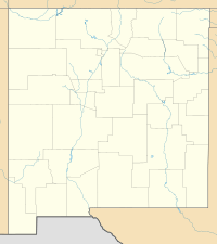
| Range coordinates | 32°57′47″N 107°13′50″W / 32.9631°N 107.2306°W |
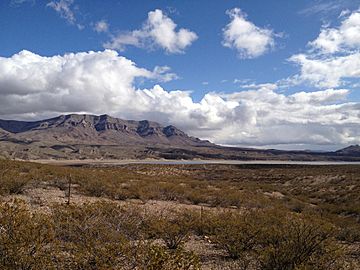
The Caballo Mountains are a mountain range in New Mexico, United States. Their name comes from the Spanish word "Caballo," which means "horse." These mountains are mostly found in Sierra and Doña Ana Counties.
You can find the Caballo Mountains east of the Rio Grande river and Caballo Lake. To their west is a desert area called the Jornada del Muerto. The towns closest to the mountains are Truth or Consequences and Hatch. Most of the land in the Caballo Mountains is public land, managed by the Bureau of Land Management. These mountains are special because their rocks show a very complete history of the Earth's changes over millions of years.
You can reach the mountains by car using Interstate 25 from the west or New Mexico State Road 51 from the north. There are also dirt roads on the east side.
Contents
Exploring the Caballo Mountains
The Caballo Mountains stretch from north to south for about 32 miles (50 km). They are usually 3 to 6 miles (5 to 10 km) wide. The highest point in the range is Timber Mountain, which stands at 7,565 feet tall.
Water in the Mountains
The way water flows in the Caballo Mountains changes a lot depending on the area. There are no rivers that flow all year round through the mountains. However, the Rio Grande river is very close to the north, west, and south sides of the range.
In the northern part of the mountains, water drains into the Rio Grande through canyons like Ash Canyon and Mescal Canyon. These streams only flow after it rains. On the steep western side, water flows directly into the Rio Grande through many small, short canyons. These canyons are also temporary and dry up quickly.
The eastern side of the mountains has two main drainage areas. These areas are not as steep as the western side. Water from the southern part of the east side flows into Barbee Draw. This stream eventually joins the Rio Grande near Rincon, New Mexico. The northern part of the east side is drained by Jornada Draw. This area is a closed basin, meaning its water does not reach the Rio Grande.
The Amazing Geology of the Mountains
The Caballo Mountains are very important for geologists, who study rocks and the Earth. This is because the mountains show a wide variety of rocks from different time periods. Geologists can learn a lot about Earth's history here.
Scientists can figure out the age of rocks in two ways:
- Relative dating: This involves comparing where a rock layer is found compared to other layers. Layers lower down are usually older. This helps scientists understand if rocks have been folded or moved by faults.
- Absolute dating: This method uses chemicals in the rocks to find their exact age in years.
By studying the type of rock (like igneous, metamorphic, or sedimentary), the size of crystals or sediments in them, and any fossils, scientists can learn about the climate and conditions when the rocks formed.
Over time, weathering and erosion wear away rocks on the Earth's surface. So, no place has a complete record of all rocks ever deposited there. But the Caballo Mountains are special in New Mexico. Their exposed rocks start from the very old Precambrian time and continue through almost every major geological period up to today. This gives us an amazing look at the geological past of southern New Mexico.
Layers of Rock: Stratigraphy
The oldest rocks in the Caballos are called "basement rocks." These include granite and metamorphic rocks like amphibolite and gneiss. They formed in the early to middle Proterozoic eon, billions of years ago.
During the early and middle Paleozoic era, southern New Mexico was sometimes covered by shallow tropical seas and sometimes exposed to air. This led to layers of sedimentary rocks like:
- Bliss Formation: Sandstone and siltstone (from Cambrian to Ordovician periods).
- El Paso Formation: Dolomites and limestones (from the Ordovician period).
- Montoya Formation: Dolomites (from the Ordovician period).
- Fusselman Dolomite: (from the Silurian period).
- Percha Shale: (from the Devonian period).
- Lake Valley Formation: Limestones (from the Mississippian period).
There's a gap in the rock record after the Lake Valley Formation, covering parts of the Mississippian and early Pennsylvanian periods. During the Pennsylvanian and Permian periods, a major event called the Ancestral Rocky Mountains created new uplifts and basins. Rocks from this time include the Magdalena Group, which has both marine (sea) and non-marine deposits. Other rocks from this time are the Red House Formation, Nakaye Formation, Bar B Formation, and Abo Formation. The Permian period ends with the Yeso Formation and Meseta Blanca Sandstone Member.
Most of the rocks from the Mesozoic era are missing in the Caballo Mountains. There's another gap in the rock record that includes all of the Triassic and Jurassic periods. The next oldest rocks are from the Cretaceous period and include:
- Dakota Sandstone
- Rio Salado Tongue Member of Mancos Shale
- Tres Hermanos Formation
- Cross Tongue Member of Mancos Shale
- Gallup Sandstone
- Crevasse Canyon Formation
- McRae Formation
The Mesozoic rocks end with another gap. Above that, we find the Love Ranch Formation, which formed in the Paleocene to early Eocene epochs. During the Eocene, a lot of volcanic activity happened in southern New Mexico. In the Caballo Mountains, you can see this in the Palm Park Formation, which is a thick layer of volcanic mudstones and sandstones. Next is the Bell Top Formation, made of rhyolite and basalt. In the southern Caballos, there are also remnants of flood basalts from the Oligocene epoch.
Later, during the Miocene and Pliocene epochs, the Santa Fe Group (geology) was deposited. This thick layer includes the Hayner Ranch Formation, Rincon Valley Formation, Selden basalts, and the Camp Rice/Palomas Formations. The most recent deposits are Quaternary and Holocene alluvium, which are loose sediments like boulders, cobbles, and gravel.
How the Mountains Formed: Tectonics
The Rio Grande Rift is a huge crack in the Earth's crust that stretches about 680 miles (1,100 km) from Colorado to Mexico. It formed because the Earth's crust was being pulled apart. This pulling apart created a series of basins (low areas) between the Colorado Plateau and the main part of North America. In this rift zone, the Earth's crust is thinner, there are many faults, and there's a lot of volcanism.
The formation of the Rio Grande Rift happened in three main stages:
- Stage 1 (late Eocene to early Oligocene): Huge volcanic eruptions happened from calderas (collapsed volcanoes) in nearby areas.
- Stage 2 (late Oligocene to late Miocene): The Caballo Mountains began to rise during this time.
- Stage 3 (late Miocene or early Pliocene to present): Volcanic activity continued, and movement along old and new faults shaped the landscape.
Minerals and Mining
The Caballo Mountains don't have many large mineral deposits, so mining hasn't been a huge industry. However, people started looking for minerals here around 1883. Several mines opened in the early 1900s.
Mining activity focused on three main areas:
- Northern Red Hills: Mostly for fluorspar.
- Palomas Gap: For copper, vanadium, lead, and fluorspar.
- Southern Caballos: For gold, fluorspar, barite, and manganese.
Before 1952, the total value of copper, silver, gold, and lead mined from the Caballos was less than $200,000. Today, fluorspar is the most common mineral mined here. The biggest fluorspar deposits are found in very old granite and a type of dolomite rock.
Wildlife and Plants
Like many mountains in southern New Mexico, the Caballo Mountains are a tough place for plants and animals to live. There's very little permanent water, except for some temporary streams and areas near the Rio Grande. Rain quickly evaporates or soaks into the ground, leaving little for living things. So, managing water is very important for both plants and animals here.
The soils on the mountains are generally rocky and thin.
Plant Life
The plants in the Caballo Mountains are typical of the Chihuahuan Desert. You'll find desert scrublands and grasslands. Common shrubs include:
- Creosote bush (Larrea tridentata)
- Honey mesquite (Prosopis glandulosa)
- Soaptree yucca (Yucca elata)
- Four-winged saltbush (Atriplex canescens)
Common grasses include:
- Black grama (Bouteloua eriopoda)
- Blue grama (Bouteloua gracilis)
- Sideoats grama (Bouteloua curtipendula)
- Alkali sacaton (Sporobolus airoides)
Animal Life
The most common large predators in the mountains are mountain lions (Felis concolor) and coyotes (Canis latrans). Other common mammals include:
- Black-tailed jackrabbit (Lepus californicus)
- Desert cottontail (Sylvilagus auduboni)
- Kangaroo rats (Dipodomys merriami and Dipodomys spectabilis)
Birds of prey you might see include:
- Golden eagles (Aquila chrysaetos)
- Swainson's hawk (Buteo swainsoni)
- Northern harrier (Circus cyaneus)
- Burrowing owl (Athene cunicularia)
Other common birds are:
- Roadrunner (Geococcyx californianus)
- Quail (Callipepla gambelii and Callipepla squamata)
- Doves (Zenaida macroura and Zenaida asiatica)
Common reptiles include:
- Collared lizards (Crotaphytus collaris)
- Roundtail Horned Lizard (Phrynosoma modestum)
- Striped whipsnake (Masticophis taeniatus)
- Western diamondback rattlesnake (Crotalus atrox)
See also
 In Spanish: Sierra del Caballo para niños
 | Jewel Prestage |
 | Ella Baker |
 | Fannie Lou Hamer |


