Clark County, Washington facts for kids
Quick facts for kids
Clark County
|
||
|---|---|---|

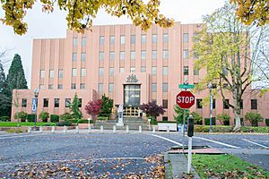
Clark County Courthouse
|
||
|
||

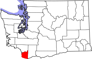
Location within the U.S. state of Washington
|
||
 Washington's location within the U.S. |
||
| Country | ||
| State | ||
| Founded | August 20, 1845 as Vancouver District | |
| Named for | William Clark on September 3, 1849 | |
| Seat | Vancouver | |
| Largest city | Vancouver | |
| Area | ||
| • Total | 656 sq mi (1,700 km2) | |
| • Land | 629 sq mi (1,630 km2) | |
| • Water | 27 sq mi (70 km2) 4.1%% | |
| Population
(2020)
|
||
| • Total | 503,311 | |
| • Estimate
(2023)
|
521,150 |
|
| • Density | 767.2/sq mi (296.23/km2) | |
| Time zone | UTC−8 (Pacific) | |
| • Summer (DST) | UTC−7 (PDT) | |
| Congressional district | 3rd | |
Clark County is the southernmost county in the state of Washington, USA. It is home to over 500,000 people, making it the fifth-most populated county in Washington. The main city and county seat is Vancouver.
This county was first called Vancouver County in 1845. It was later renamed in 1849 after William Clark from the famous Lewis and Clark Expedition. Clark County was the very first county created in Washington. It was formed by the Provisional Government of Oregon on August 20, 1845. At that time, it covered almost all of what is now Washington state. Clark County is located across the Columbia River from Portland, Oregon.
Contents
History of Clark County
Clark County was first created on August 20, 1845. It was known as the Vancouver District. It got its name from the town of Vancouver. Before this, the area was part of three other districts.
In the beginning, Clark County included all the land north of the Columbia River. This stretched from the Rocky Mountains to the border of Alaska. On December 21, 1845, its name changed to Vancouver County. It reached as far north as what is now British Columbia, Canada. In 1846, the United States and Canada set their border at the 49th parallel.
On August 13, 1848, the President signed a law creating the Oregon Territory. On September 3, 1849, the name changed again to Clarke County. This was to honor the explorer William Clark. At this time, it still included all of present-day Washington. Over the years, the county was divided many times. It reached its current size in 1880. The spelling of "Clarke" was finally corrected to "Clark" in 1925.
In September 1902, a huge fire called the Yacolt Burn started. It began in nearby Skamania County. The fire spread west for 12 miles towards Yacolt. It almost burned down the entire town. After the fire, collecting the remaining timber became a very profitable business for a while.
Geography and Landscape
Clark County covers about 656 square miles. Most of this area, 629 square miles, is land. The remaining 27 square miles, or 4.1%, is water. It is the fifth-smallest county in Washington by land area.
The Columbia River borders Clark County on two sides. The North Fork of the Lewis River is to the north. Other rivers like the East Fork of the Lewis River and the Washougal River flow through the county. Salmon Creek is the largest stream that starts and ends only within the county. It flows into Vancouver Lake and then into the Columbia River.
Clark County's landscape is shaped by its location. It sits between the Pacific Coast and Cascade Range mountains. These mountains are volcanic. Ancient glaciers also helped form a U-shaped valley here. This valley meets the Columbia River valley as the river leaves the Columbia River Gorge. The soil in the county is often rich and fertile.
The central and southwest parts of the county are mostly flat. These areas were formed by huge floods from ancient Lake Missoula. These floods happened about 15,000 to 13,000 years ago. They created low, flat areas known as "plains."
Many lakes are found near the Columbia River in the lowlands. These include Vancouver Lake near Ridgefield. The eastern and northern parts of Clark County have forested hills. These hills are part of the Cascade Mountains. They can reach up to 4,000 feet high near the border with Skamania County. Larch Mountain is the tallest standalone peak in the county.
You can see several large mountains from Clark County. These include Mount Hood, Mount St. Helens, and Mount Adams. In winter, cold winds from the Columbia River Gorge can bring freezing rain. This creates a layer of ice, often called a "silver thaw." This is especially common in the southeastern parts of the county. On the other hand, warm winds from the southwest are known as the "Pineapple Express".
Weather and Storms
Spring thaws can cause rivers to swell. Two major floods happened on the Columbia River in June 1894 and May 1948. The 1948 flood almost reached the top of the Interstate Bridge supports. It completely destroyed nearby Vanport, Oregon. Building The Dalles Dam helped reduce such large floods.
Clark County has also experienced strong windstorms. The Columbus Day windstorm hit on October 12, 1962. On April 6, 1972, a tornado struck a local school. Another strong storm in November 1981 brought winds up to 70 miles per hour. Other notable storms include one on January 20, 1993, and the Guadalupe Day storm on December 12, 1995. A small tornado on January 10, 2008, damaged buildings in Hazel Dell.
Nature and Wildlife
The plants and animals in Clark County change depending on the area. In lowlands, you'll find large trees like big leaf maple and western red cedar. Higher up, there are Garry oak trees. In areas affected by fire, you might see lodgepole pine and Douglas fir. Other common trees include grand fir and silver fir.
The county is home to many birds. These include great blue heron, raptors like barred owl and bald eagle, and various corvids like ravens and crows. The local streams are important for different types of salmon. The Vancouver Trout Hatchery also helps with fish conservation.
Larger animals in the county include black-tailed deer, coyote, raccoon, and skunk. Sometimes, people spot lynx, bobcat, black bear, cougar, and elk, especially in the northern parts of the county. Native people like the Klickitat tribe and Chinook used to eat foods like salmon, huckleberry, and Camassia quamash. The city of Camas, Washington is named after the Camassia quamash plant.
Places to See
Clark County has many natural and recreational spots:
- Cascade Mountains
- Columbia River
- Vancouver Lake
- East Fork Lewis River
- Lacamas Creek
- Lacamas Lake
- Battle Ground Lake
- Moulton Falls
- Lucia Falls
- Larch Mountain
- Silver Star Mountain
- Green Mountain
- Lewisville Park
- Daybreak Park
- Vancouver Lake Park
- Klineline Park
Main Roads
Here are some of the major highways that run through Clark County:
 Interstate 5
 Interstate 205
 State Route 14
 State Route 500
 State Route 501
 State Route 502
 State Route 503
Old Main Roads
Some roads that were once major highways:
Neighboring Counties
Clark County shares borders with these counties:
- Cowlitz County - to the north
- Skamania County - to the east
- Multnomah County, Oregon - to the south
- Columbia County, Oregon - to the southwest
Protected Natural Areas
These are special areas in Clark County that are protected for nature and history:
- Fort Vancouver National Historic Site (part)
- Gifford Pinchot National Forest (part)
- Ridgefield National Wildlife Refuge
- Steigerwald Lake National Wildlife Refuge
Economy and Jobs
Clark County's biggest industries are health care, business services, and retail. Many people who live in Clark County travel to Portland, Oregon for work. In 2019, about 65,000 Clark County residents commuted to Portland. About 17,000 people from Oregon also traveled to Clark County for their jobs.
Washington state does not have a state income tax. However, people who work in Oregon must pay income tax to Oregon for the money they earn there. Clark County residents also often cross the Columbia River to shop in Oregon. Oregon does not have sales tax, which means shoppers don't pay extra tax on items they buy. This can lead to less sales tax money for Clark County.
Population and People
| Historical population | |||
|---|---|---|---|
| Census | Pop. | %± | |
| 1850 | 643 | — | |
| 1860 | 2,384 | 270.8% | |
| 1870 | 3,081 | 29.2% | |
| 1880 | 5,490 | 78.2% | |
| 1890 | 11,709 | 113.3% | |
| 1900 | 13,419 | 14.6% | |
| 1910 | 26,115 | 94.6% | |
| 1920 | 32,805 | 25.6% | |
| 1930 | 40,316 | 22.9% | |
| 1940 | 49,852 | 23.7% | |
| 1950 | 85,307 | 71.1% | |
| 1960 | 93,809 | 10.0% | |
| 1970 | 128,454 | 36.9% | |
| 1980 | 192,227 | 49.6% | |
| 1990 | 238,053 | 23.8% | |
| 2000 | 345,238 | 45.0% | |
| 2010 | 425,363 | 23.2% | |
| 2020 | 503,311 | 18.3% | |
| 2023 (est.) | 521,150 | 22.5% | |
| U.S. Decennial Census 1790–1960 1900–1990 1990–2000 2010–2020 |
|||
2020 Population Count
In 2020, Clark County had 503,311 people living there. There were 184,173 households. On average, there were about 800 people per square mile.
Most people in the county, about 85.2%, were White. Other groups included 2.6% African American, 1.2% Native American, 5.4% Asian, and 1.0% Pacific Islander. About 4.6% of people were from two or more races. People of Hispanic or Latino background made up 11% of the population.
The average household had 2.67 people. About 23.0% of the population was under 18 years old. About 16.3% of the population was over 65 years old. The county had slightly more females (50.3%) than males (49.7%).
The average income for a household was $82,719. The income per person was $39,371. About 9.0% of the population lived below the poverty line, meaning they had very low incomes.
2010 Population Count
In 2010, Clark County had 425,363 people. There were 158,099 households and 110,672 families. The population density was about 676 people per square mile.
The racial makeup was similar to 2020. About 85.4% were White, 4.1% Asian, 2.0% African American, and 0.9% American Indian. People of Hispanic or Latino background made up 7.6% of the population. Many people had German, Irish, or English ancestry.
About 36.3% of households had children under 18. Most households (53.6%) were married couples. The average household size was 2.67 people. The average age in the county was 36.7 years.
The average income for a household was $58,262. About 10.9% of the population lived below the poverty line. This included 14.9% of those under age 18.
Religious Groups
Clark County has many different religious groups. No single group makes up a very large part of the population. Some of the larger groups include non-denominational Christians, the Catholic Church, and The Church of Jesus Christ of Latter-day Saints. The Evangelical Lutheran Church of America also has members here. The area is also home to a large number of members of the Old Apostolic Lutheran Church.
Emergency Services
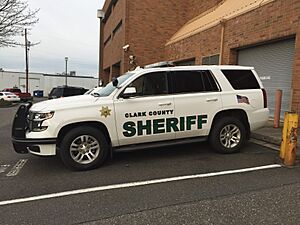
The Clark County Sheriff's Office is the main law enforcement agency for the county. It was started in 1849, making it the oldest law enforcement group in Washington state. Sheriff John Horch and Undersheriff James Hansen lead the office.
On March 16, 2014, Clark County Fire & Rescue got a new fireboat called the Mary Firstenburg. This boat was bought with help from a gift from the Firstenburg family and a special grant.
Communities in Clark County
Cities
- Battle Ground
- Camas
- La Center
- Ridgefield
- Vancouver (county seat)
- Washougal
- Woodland (mostly in Cowlitz County)
Town
Census-Designated Places
These are areas that are like towns but are not officially incorporated as cities.
Unincorporated Communities
These are smaller communities that are not part of any city or census-designated place.
- Chelatchie
- Etna
- Fargher Lake
- Hall
- Heisson
- Mill Plain
- Proebstel
Education in Clark County
Clark County has many school districts:
- Battle Ground School District
- Camas School District
- Evergreen School District (Clark)
- Green Mountain School District
- Hockinson School District
- La Center School District
- Ridgefield School District
- Vancouver Public Schools
- Washougal School District
- Woodland School District
There are also state-run schools:
- Washington State School for the Blind
- Washington School for the Deaf
See also
 In Spanish: Condado de Clark (Washington) para niños
 | Charles R. Drew |
 | Benjamin Banneker |
 | Jane C. Wright |
 | Roger Arliner Young |


