Cumberland County, Maine facts for kids
Quick facts for kids
Cumberland County
|
||
|---|---|---|

|
||
|
||

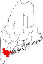
Location within the U.S. state of Maine
|
||
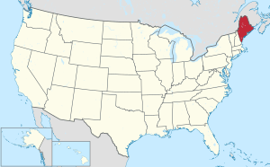
 Maine's location within the U.S. |
||
| Country | ||
| State | ||
| Founded | November 1, 1760 | |
| Named for | Prince William, Duke of Cumberland | |
| Seat | Portland | |
| Largest city | Portland | |
| Area | ||
| • Total | 1,217 sq mi (3,150 km2) | |
| • Land | 835 sq mi (2,160 km2) | |
| • Water | 383 sq mi (990 km2) 31%% | |
| Population
(2020)
|
||
| • Total | 303,069 | |
| • Estimate
(2021)
|
305,231 |
|
| • Density | 249.03/sq mi (96.15/km2) | |
| Time zone | UTC−5 (Eastern) | |
| • Summer (DST) | UTC−4 (EDT) | |
| Congressional district | 1st | |
Cumberland County is a county located in the state of Maine in the United States. It is the most populated county in Maine. In 2020, about 303,069 people lived here. The main city and county seat is Portland.
Cumberland County was created in 1760. It was named after William, Duke of Cumberland. He was a son of King George II. The county is home to Sebago Lake. This lake is the deepest and second-largest body of water in Maine. It provides drinking water to most of the county. Cumberland County is also a major center for business and industry in Maine. It has the busy Port of Portland and is home to large companies.
Contents
Geography of Cumberland County
Cumberland County covers a total area of about 1,217 square miles. About 835 square miles of this is land. The remaining 382 square miles (31%) is water.
Most of Casco Bay and its many islands are part of the county. This includes islands east of East Cundy Point. The northern part of Saco Bay is also within the county. Sebago Lake flows into Casco Bay through the Presumpscot River. The Nonesuch River flows into Saco Bay. To the north and west of Sebago Lake, the land starts to rise into the foothills of the Appalachian Mountains.
Neighboring Counties
Cumberland County shares borders with these other counties:
- Androscoggin County – to the north
- Oxford County – to the northwest
- Sagadahoc County – to the northeast
- York County – to the southwest
Main Roads
Many important roads run through Cumberland County:
Protected Natural Areas
Part of the Rachel Carson National Wildlife Refuge is located in Cumberland County. This refuge helps protect wildlife and their habitats.
People in Cumberland County
| Historical population | |||
|---|---|---|---|
| Census | Pop. | %± | |
| 1790 | 25,530 | — | |
| 1800 | 38,208 | 49.7% | |
| 1810 | 42,831 | 12.1% | |
| 1820 | 49,445 | 15.4% | |
| 1830 | 60,102 | 21.6% | |
| 1840 | 68,658 | 14.2% | |
| 1850 | 79,538 | 15.8% | |
| 1860 | 75,591 | −5.0% | |
| 1870 | 82,021 | 8.5% | |
| 1880 | 86,359 | 5.3% | |
| 1890 | 90,949 | 5.3% | |
| 1900 | 100,689 | 10.7% | |
| 1910 | 112,014 | 11.2% | |
| 1920 | 124,376 | 11.0% | |
| 1930 | 134,645 | 8.3% | |
| 1940 | 146,000 | 8.4% | |
| 1950 | 169,201 | 15.9% | |
| 1960 | 182,751 | 8.0% | |
| 1970 | 192,528 | 5.3% | |
| 1980 | 215,789 | 12.1% | |
| 1990 | 243,135 | 12.7% | |
| 2000 | 265,612 | 9.2% | |
| 2010 | 281,674 | 6.0% | |
| 2020 | 303,069 | 7.6% | |
| 2023 (est.) | 310,230 | 10.1% | |
| U.S. Decennial Census 1790–1960 1900–1990 1990–2000 2010–2019 |
|||
2010 Census Information
In 2010, there were 281,674 people living in Cumberland County. There were 117,339 households. The population density was about 337 people per square mile.
Most people in the county were white (92.8%). Other groups included Black or African American (2.4%), Asian (2.0%), and American Indian (0.3%). About 1.8% of the population was of Hispanic or Latino background. Many people had ancestors from England (22.7%) and Ireland (21.1%).
The average household had 2.32 people. The average family had 2.90 people. The average age of people in the county was 41 years old.
Cities and Towns
Cumberland County has several cities and many towns.
Cities
- Portland (the county seat)
- South Portland
- Westbrook
Towns
Census-Designated Places
These are areas identified by the census bureau for statistics.
Other Communities
These are smaller, unincorporated communities:
- Bailey Island
- Higgins Beach
- North Bridgton
- Orr's Island
- Prouts Neck
- Sebago Lake
- South Casco
- South Freeport
Education
Cumberland County has many school districts that serve its communities:
- Brunswick School District
- Cape Elizabeth School District
- Chebeague Island School District
- Falmouth School District
- Gorham School District
- Long Island School District
- Portland Public Schools
- Regional School Unit 05
- Regional School Unit 14
- Scarborough School District
- School Administrative District 06
- School Administrative District 15
- School Administrative District 17
- School Administrative District 55
- School Administrative District 61
- School Administrative District 51
- School Administrative District 75
- Sebago Public Schools
- South Portland School District
- Westbrook School District
- Yarmouth School District
The Governor Baxter School for the Deaf, a state-run school, is also located in the county.
See also
 In Spanish: Condado de Cumberland (Maine) para niños
 | Kyle Baker |
 | Joseph Yoakum |
 | Laura Wheeler Waring |
 | Henry Ossawa Tanner |


