
Gulf of Mexico facts for kids
Quick facts for kids Gulf of Mexico |
|
|---|---|
| Golfo de México | |
.png)
Bathymetry of the Gulf of Mexico
|
|
| Location | American Mediterranean Sea |
| Coordinates | 25°N 90°W / 25°N 90°W |
| River sources | Rio Grande, Mississippi River, Mobile River, Panuco River, Jamapa River, Pascagoula River, Tecolutla River, Usumacinta River, Apalachicola River |
| Ocean/sea sources | Atlantic Ocean, Caribbean Sea |
| Basin countries | |
| Max. width | 1,500 km (930 mi) |
| Surface area | 1,550,000 km2 (600,000 sq mi) |
| Average depth | 1,615 m (5,299 ft) |
| Max. depth | 3,750 to 4,384 m (12,303 to 14,383 ft) |
| Settlements | Veracruz, Houston, New Orleans, Corpus Christi, Tampa, Havana, Southwest Florida, Mobile, Gulfport, Matamoros, Brownsville, Tampico, Key West, Cabo Catoche / Cancún, Ciudad del Carmen, Coatzacoalcos, Panama City |
The Gulf of Mexico (called Golfo de México in Spanish) is a large oceanic basin, like a giant bowl in the ocean floor. It is a marginal sea of the Atlantic Ocean, meaning it's a part of the Atlantic that is mostly surrounded by land. The Gulf is bordered by the United States to the north, Mexico to the south and west, and Cuba to the southeast.
This huge body of water formed about 300 million years ago because of plate tectonics, which is how Earth's large land plates move. The Gulf of Mexico basin is shaped like an oval. Its floor is made of sedimentary rocks and newer sediments. It connects to the Atlantic Ocean through the Straits of Florida (between the U.S. and Cuba) and to the Caribbean Sea through the Yucatán Channel (between Mexico and Cuba). Because these connections are narrow, the Gulf has very small tides.
The Gulf of Mexico covers about 1.6 million square kilometers (617,000 square miles). Nearly half of it is shallow water over the continental shelf. The Gulf is one of the most important places in the world for drilling for oil and gas from under the sea. It produces 14% of the United States' total oil. The moisture from the Gulf also affects weather across the United States, including severe storms in Tornado Alley.
Contents
- What is the Gulf of Mexico's name?
- Where is the Gulf of Mexico located?
- How many people live near the Gulf?
- How did the Gulf of Mexico form?
- How does water move in the Gulf?
- What is the history of the Gulf?
- What is the geography of the Gulf?
- What shipwrecks are in the Gulf?
- What animals live in the Gulf?
- What are the environmental concerns in the Gulf?
- How does the Gulf affect weather?
- Images for kids
- See also
What is the Gulf of Mexico's name?
The name "Gulf of Mexico" comes from the word Mexica, which refers to the Nahuatl-speaking people, also known as the Aztecs. In the Aztec religion, they called the Gulf Chalchiuhtlicueyecatl, meaning 'House of Chalchiuhtlicue', who was the goddess of the seas.
The Maya civilization, who used the Gulf for trade, likely called it nahá, meaning 'great water'. Early European maps sometimes called it the "Sea of the North" or "Gulf of Florida." The name "Gulf of Mexico" first appeared on a map in 1550. It became the most common name by the mid-1600s.
On January 20, 2025, the United States president signed an order to call the Gulf waters near the U.S. the "Gulf of America." However, the name "Gulf of Mexico" is officially recognized by the International Hydrographic Organization, which helps standardize names for international waters. Mexico's president objected to this name change.
Where is the Gulf of Mexico located?

The eastern, northern, and northwestern shores of the Gulf of Mexico are along the U.S. states of Florida, Alabama, Mississippi, Louisiana, and Texas. The U.S. coastline is about 2,700 kilometers (1,678 miles) long. It receives water from 33 major rivers.
The Mexican coastline is about 2,200 kilometers (1,367 miles) long. It stretches from the U.S. border to the northern tip of the Yucatán Peninsula. Cuba has a smaller coastline along the Gulf, about 60 to 250 miles (97 to 402 kilometers) long. The Gulf supports large fishing industries in the U.S., Mexico, and Cuba.
How many people live near the Gulf?
About 15.8 million people live in the U.S. counties directly bordering the Gulf of Mexico. The six Mexican states along the Gulf have a total population of 19.1 million people. Three provinces in northwest Cuba, including Havana, also border the Gulf, with a combined population of over 3.2 million.
In 1975, more than 10,000 workers lived temporarily on offshore drilling rigs in the Gulf. As technology improved, fewer workers were needed on the rigs.
How did the Gulf of Mexico form?

Geologists believe that the Gulf of Mexico did not exist before the late Triassic period. Back then, this area was dry land, part of the supercontinent Pangaea. This land was south of a long mountain range.
The Gulf basin formed when Pangaea began to break apart. First, deep valleys formed and filled with sediments. Then, the Earth's crust stretched and became thinner. This stretching created a connection to the Pacific Ocean and later to the Atlantic Ocean, allowing water to flood the basin.
Later, the basin continued to sink as layers of sediments built up over millions of years. This process made the Gulf deeper. The Gulf of Mexico is a great example of a "passive margin," which means it's a stable edge of a continent where the land gently slopes into the ocean.
The Gulf of Mexico has several main areas:
- The Gulf of Mexico basin, which includes the deepest part, the Sigsbee Deep.
- The Northeast Gulf of Mexico, from Mississippi to Florida.
- The South Florida Continental Shelf and Slope, including the Florida Keys.
- The Campeche Bank and Bay of Campeche in Mexico.
- The Western Gulf of Mexico, from Veracruz to the Rio Grande.
- The Northwest Gulf of Mexico, from Alabama to the Rio Grande.
What are brine pools?

The Gulf of Mexico seafloor has special areas called brine pools, or "brine lakes." These are places where super salty water collects. They can be small, just 1 meter across, or very large, up to 20 kilometers long.
This salty water forms when regular Gulf water touches a layer of ancient salt called the Louann Salt, which is deep under the seafloor. This salt layer is found under most of the northern Gulf's continental shelf. When the salt moves under pressure, it can create domes or push out along slopes, allowing the salty water to escape.
Brine pools are much saltier and denser than normal seawater. This density difference means the brine doesn't mix easily with the surrounding ocean water. It flows downhill and gathers in low spots on the seafloor. These pools are often anoxic, meaning they have no oxygen, and contain gases like hydrogen sulfide and methane.
One famous brine pool, discovered in 2014, is sometimes called the "Jacuzzi of Despair." It's about 3,300 feet (1,000 meters) deep and is four to five times saltier than the surrounding water. It's also warmer, around 65°F (18°C), compared to the surrounding water at 39°F (4°C). Only special bacteria, mussels, tube worms, and some shrimp can live there.
How does water move in the Gulf?
Water moves into the Gulf from the Caribbean Sea through the Yucatan Channel. This is called the Yucatan Current. The water then leaves the Gulf through the Florida Straits as the Florida Current, which then becomes the powerful Gulf Stream.
The Yucatan Current and Florida Current are connected by a large, clockwise loop of water called the Loop Current. This Loop Current can extend far into the northeastern Gulf and is very strong, similar to the Gulf Stream. It dominates how water moves in the Gulf.
Smaller swirling currents, called eddies, break off from the Loop Current and move into the western Gulf. These eddies can be very large, up to 300 kilometers (186 miles) wide and 800 to 1,000 meters (2,625 to 3,281 feet) deep. They affect water circulation throughout almost the entire Gulf.
What is the history of the Gulf?
Early history and Spanish exploration
Even before Europeans arrived, the Maya civilization used the Gulf of Mexico as a trade route.
The first European to explore the Gulf of Mexico was possibly Amerigo Vespucci in 1497, though this trip is debated by historians. Later, Spanish explorers like Hernán Cortés and Francisco Hernández de Córdoba explored the coasts in the early 1500s. Hernández de Córdoba discovered the Yucatán Peninsula in 1517, which led to more Spanish expeditions and the conquest of Mexico.
In 1523, a Spanish treasure ship sank off Padre Island, Texas. This disaster, and others, led Spain to plan settlements along the northern Gulf Coast to protect shipping. One such settlement, led by Tristán de Luna y Arellano, landed at Pensacola Bay in 1559.
In 1699, French explorer Pierre Le Moyne d'Iberville founded the first permanent European settlement on the Gulf Coast, called Fort Maurepas (now Ocean Springs, Mississippi). The French also built a small fort at the mouth of the Mississippi River.
What is the geography of the Gulf?

The Gulf of Mexico has many bays and smaller inlets along its shoreline. Major rivers that flow into the Gulf include the Mississippi River and the Rio Grande in the north, and the Grijalva and Usumacinta rivers in the south. The land along the Gulf coast is generally low-lying, with marshes, swamps, and sandy beaches.
The Gulf is important for its oil and gas, which are drilled from offshore rigs, especially in the western Gulf and the Bay of Campeche. Fishing is another major industry, with catches like red snapper, shrimp, and crabs. Oysters are also harvested. Other important activities include shipping, chemical processing, and tourism.
The Gulf of Mexico is usually very stable, with few earthquakes. However, a magnitude 6.0 earthquake was felt in 2006 from Louisiana to Florida. It caused no major damage but was the largest earthquake recorded in the region in three decades.
Maritime boundaries
Countries around the Gulf have agreements about their maritime borders:
- Cuba and Mexico: Agreed on their exclusive economic zone boundaries in 1976.
- Cuba and United States: Agreed on their maritime boundary in 1977.
- Mexico and United States: Have several treaties from 1970, 1978, and 2000 that define their boundaries, including the continental shelf beyond 200 nautical miles. In 2009, Mexico's claim for an extended continental shelf was accepted, meaning Mexico and the U.S. will need to agree on this area.
What shipwrecks are in the Gulf?
The Gulf of Mexico holds many shipwrecks. One ship, now called the Mardi Gras, sank in the early 1800s about 56 kilometers (35 miles) off the coast of Louisiana. Its true identity is still a mystery. It was found in 2002 by an oilfield inspection crew. In 2007, scientists studied the wreck and recovered artifacts for display.
On July 30, 1942, during World War II, the SS Robert E. Lee steamship was torpedoed by a German submarine, U-166, near the Mississippi River. The ship sank quickly, and 25 people were lost. The escort ship, PC-566, then sank the U-166. In 2001, both wrecks were found deep underwater.
What animals live in the Gulf?
The Gulf of Mexico is home to many different kinds of life. This includes tiny organisms, crabs, sea pens, fish, and large animals like cetaceans (whales and dolphins). Recently, a unique type of Bryde's whale that lives only in the Gulf was identified as one of the most endangered whales in the world.
The Gulf of Mexico provides more fish, shrimp, and shellfish each year than the south and mid-Atlantic, Chesapeake Bay, and New England areas combined in the U.S.
The Smithsonian Institution has a large collection of Gulf of Mexico specimens. These samples were collected over many years to help scientists understand the potential impacts of oil and gas exploration. They are now important for studying the effects of events like the Deepwater Horizon oil spill.
What are the environmental concerns in the Gulf?

The main environmental threats to the Gulf are pollution from farms and oil drilling. There are 27,000 abandoned oil and gas wells under the Gulf, and their environmental impact is not always checked. In 1973, the U.S. Environmental Protection Agency stopped factories from dumping chemical waste into the Gulf.
The Gulf also experiences frequent "red tide" algae blooms. These blooms kill fish and marine mammals and can cause breathing problems for humans and pets near the shore.
A large hypoxic "dead zone" exists in the Gulf along the Texas–Louisiana coast. This means there is very little oxygen in the water. This dead zone has roughly doubled in size between 1985 and 2008, reaching its largest recorded size in 2017. It's caused by too much nitrogen and phosphorus from farm runoff, which leads to algae blooms that use up the oxygen. This lack of oxygen can harm fish and other marine life.
Oil spills in the Gulf
The oil industry has thousands of small accidents in the Gulf of Mexico every year. The largest oil spill in the Gulf happened in 1979, when the Ixtoc I oil platform in the Bay of Campeche had a huge explosion and blowout. Oil leaked until the well was capped in April 1980.

On April 20, 2010, the Deepwater Horizon oil platform, operated by BP, exploded and sank off the coast of Louisiana. Oil flowed from the wellhead on the ocean floor, creating a massive oil slick. This spill threatened marine life, coastal wetlands, and the jobs of shrimpers and fishermen. The leak was finally stopped on July 15, 2010. BP later agreed to pay $18.7 billion to the U.S. government and several states for cleanup and damages. By 2015, BP had spent $54 billion on the spill.
On May 12, 2016, oil leaked from Shell's Brutus oil rig, releasing 2,100 barrels of oil. This created an oil slick about 5 to 34 kilometers (3 to 21 miles) wide off the coast of Louisiana.
How does the Gulf affect weather?
The warm water in the Gulf of Mexico can power strong and dangerous Atlantic hurricanes, like Hurricane Katrina in 2005. When a hurricane passes over, it can cool the water, but because the Gulf is shallower, the water temperature quickly warms up again, making it possible for more hurricanes to form. From 1970 to 2020, the Gulf's surface temperatures warmed twice as fast as the global ocean surface.
Moisture from the Gulf of Mexico is a key factor for tornadoes and severe weather in Tornado Alley in the United States. Dry air from the Rocky Mountains mixes with the Gulf's moisture, creating storms that can produce very powerful tornadoes.
Images for kids
-
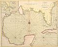
An English nautical chart dated 1700 labels the body of water "the Great Bay of Mexico".
-
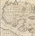
An English nautical chart dated 1775 labels it "the Bay of Mexico", now glossing "Mexico" as an alternative name for New Spain.
-
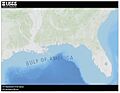
U.S. Geological Survey map, February 2025
-
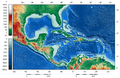
The shaded relief map of the Gulf of Mexico and the Caribbean area
-
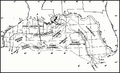
Map of northern part of Gulf of Mexico

_-_The_fourth_book._Describing_The_West-India_navigation,_from_Hudson%27s_Bay_to_the_River_Amazones._Particularly_delineating_The_Sea_Coasts,_Capes,_Headlands,_(14780240045).jpg)


See also
 In Spanish: Golfo de México para niños
