
Saint Vincent and the Grenadines facts for kids
Quick facts for kids
Saint Vincent and the Grenadines
|
|
|---|---|
|
Anthem: "Saint Vincent, Land So Beautiful"
|
|
 |
|
| Capital and largest city
|
Kingstown 13°10′N 61°14′W / 13.167°N 61.233°W |
| Official languages | English |
| Vernacular language | Vincentian Creole |
| Ethnic groups
(2020)
|
|
| Religion
(2020)
|
|
| Demonym(s) | Vincentian Grenadinian Saint Vincentian Vincy (colloquial) |
| Government | Unitary parliamentary constitutional monarchy |
|
• Monarch
|
Charles III |
| Dame Susan Dougan | |
| Godwin Friday | |
| Legislature | House of Assembly |
| Independence | |
|
• Associated State
|
27 October 1969 |
|
• from the United Kingdom
|
27 October 1979 |
| Area | |
|
• Total
|
389 km2 (150 sq mi) (184th) |
|
• Water (%)
|
negligible |
| Population | |
|
• 2022 estimate
|
110,872 (180th) |
|
• 2012 census
|
109,991 |
|
• Density
|
307/km2 (795.1/sq mi) (39th) |
| GDP (PPP) | 2023 estimate |
|
• Total
|
|
|
• Per capita
|
|
| GDP (nominal) | 2023 estimate |
|
• Total
|
|
|
• Per capita
|
|
| HDI (2023) | high · 76th |
| Currency | East Caribbean dollar (XCD) |
| Time zone | UTC-4 (AST) |
| Date format | mm/dd/yyyy |
| Driving side | left |
| Calling code | +1 |
| ISO 3166 code | VC |
| Internet TLD | .vc |


Saint Vincent and the Grenadines is an island country in the Caribbean. It is part of the Windward Islands in the Lesser Antilles. These islands are located where the Caribbean Sea meets the Atlantic Ocean.
The country's land area is about 369 square kilometers (142 square miles). It includes the main island of Saint Vincent. To the south are two-thirds of the northern Grenadines, which is a chain of 32 smaller islands.
Some of the Grenadines islands are lived on. These include Bequia, Mustique, Union Island, Canouan, Petit Saint Vincent, Palm Island, Mayreau, and Young Island. Other islands are not inhabited, such as Tobago Cays, Baliceaux, Battowia, Quatre, Petite Mustique, Savan, and Petit Nevis. Most of Saint Vincent and the Grenadines is in the path of hurricanes.
To the north of Saint Vincent is Saint Lucia. Barbados is to the east, and Grenada is to the south. Saint Vincent and the Grenadines has many people living in a small area. There are over 300 people per square kilometer (700 per square mile). The total population is about 110,211 people.
Kingstown is the capital city and the main port. Saint Vincent has a history as a British colony. Today, it is part of several groups, including the Organisation of Eastern Caribbean States, CARICOM, and the Commonwealth of Nations.
In April 2021, the La Soufrière volcano erupted many times. This caused "explosive events" to continue. By April 12, about 16,000 people had to leave their homes. Other nearby islands, the United Kingdom, and groups like the United Nations helped with aid. The World Bank also offered $20 million to help on April 13, 2021.
Contents
Naming the Islands
Christopher Columbus was the first European to see the main island. He named it after St. Vincent of Saragossa. His feast day was on January 22, 1498, the day Columbus first saw the island.
The name "Grenadines" comes from the Spanish city of Granada. A smaller version of the name was used to avoid confusion with the island of Grenada. Before the Spanish arrived, the native Kalinago people called the island Youloumain. This name honored Youlouca, the spirit of rainbows, who they believed lived on the island.
Island History
Early People on the Islands
Before Europeans and Africans arrived in the 1500s, different Amerindian groups lived on or passed through St. Vincent and the Grenadines. These groups included the Ciboney, Arawak, and Kalinago people. The Kalina, who were native to the island, called it Youloumain.
European Arrival and Colonization
It is believed that Christopher Columbus saw the island in 1498. He then gave it the name St Vincent. The Kalinago people strongly resisted European settlement on Saint Vincent.
The English and Dutch tried to claim the island but did not succeed. The French were the first to settle there in 1719. They settled in a town called Barrouallie on the leeward side of St Vincent. The French brought enslaved people from Africa to work on farms. These farms grew crops like sugar, coffee, and cotton.

During the Seven Years' War, the British took the island from the French. This was confirmed by the Treaty of Paris (1763). After taking control in 1763, the British started building Fort Charlotte. They also continued to bring enslaved people to work on the island's farms. The Garifuna people, who are of African and Indigenous descent, did not like the British presence. They fought against the British in the First Carib War, which lasted from 1772 to 1773.
The French took St Vincent back in 1779 during another war with the British. However, the British regained control in 1783 under the Treaty of Versailles (1783).
British Rule and the Second Carib War
The peace between the British and the Garifuna did not last. This led to the Second Carib War, from 1795 to 1797. The Garifuna leader was Joseph Chatoyer, and they had support from the French. The British forces eventually defeated them in 1797. After the war, almost 5,000 Garifuna people were sent away to Roatán (an island near Honduras), Belize, and Baliceaux in the Grenadines.
In 1806, the building of Fort Charlotte was finished.
The La Soufrière volcano erupted in 1812. This caused a lot of damage.
.svg)
The British ended slavery in Saint Vincent and other colonies in 1834. After a period of apprenticeship, slavery fully ended in 1838. This caused a shortage of workers on the farms. To solve this, many workers came from other places. From 1845 to 1850, about 2,100 Portuguese Catholic settlers arrived from Madeira. Between 1861 and 1888, many Indian laborers also arrived.
The 1900s

In 1902, the La Soufrière volcano erupted again. It killed 1,500–2,000 people. Many farms were destroyed, and the economy became worse.
Saint Vincent and the Grenadines went through different stages of being a British colony. In 1776, a group of representatives was allowed. In 1877, the British government took more direct control. In 1925, a legislative council was created, but only some people could vote. In 1951, all adults were allowed to vote.
In the 1960s, the British tried to unite Saint Vincent with other islands. This was part of a plan to gain independence from Britain. This group was called the West Indies Federation, but it broke apart in 1962.
Saint Vincent became an "associated state" of Britain on October 27, 1969. This meant Saint Vincent controlled its own affairs, but it was not fully independent yet.
In April 1979, La Soufrière erupted again. No one died, but thousands had to leave their homes. There was also a lot of damage to farms.
On October 27, 1979, Saint Vincent and the Grenadines became fully independent. This day is now the country's Independence Day, a public holiday. The country chose to remain part of the Commonwealth of Nations. This means Charles III is still the King of Saint Vincent and the Grenadines. A Governor-General represents the King on the islands.
After Independence
[[[Milton Cato]] was the country's first Prime Minister. He led the country until 1984. During his time, there was a short uprising on Union Island in December 1979. People had concerns about the central government. This uprising was quickly stopped.
James Fitz-Allen Mitchell became Prime Minister in 1984. He worked to improve cooperation between countries in the region. Hurricanes in 1980, 1987, 1998, and 1999 caused a lot of damage to farms.
In 2000, Arnhim Eustace became Prime Minister. He was later defeated in 2001 by Ralph Gonsalves. Mr. Gonsalves, known as "Comrade Ralph," served as Prime Minister for many years. He called for European nations to provide fairness for past injustices related to the slave trade. He won elections in 2005, 2010, 2015, and 2020.
In 2009, people voted on a plan to make the country a republic. This would have replaced the Queen as head of state with a president. However, the plan did not get enough votes to pass.
Saint Vincent and the Grenadines was chosen to be a temporary member of the United Nations Security Council from 2020 to 2021. This was a big achievement for such a small country.
In November 2020, Ralph Gonsalves made history by winning his fifth election in a row. In April 2021, the La Soufrière volcano erupted again. About 16,000 people were moved to safety before the eruption. In the 2025 general election, Godwin Friday's New Democratic Party won. Mr. Friday became the new Prime Minister on November 28, 2025.
Geography of the Islands

Saint Vincent and the Grenadines is located west of Barbados. It is south of Saint Lucia and north of Grenada. These islands are part of the Windward Islands in the Lesser Antilles. This is a chain of islands in the Caribbean Sea.
The country includes the main island of Saint Vincent, which is about 344 square kilometers (133 square miles). It also includes the northern two-thirds of the Grenadines. The Grenadines are a chain of smaller islands stretching south towards Grenada. This part of the Grenadines is about 45 square kilometers (17 square miles).
There are 32 islands and small sandy islands (cays) that make up Saint Vincent and the Grenadines. Nine of these islands are inhabited. These include the main island of St Vincent, and Grenadine islands like Young Island, Bequia, Mustique, Canouan, Union Island, Mayreau, Petit St Vincent, and Palm Island. Some important uninhabited islands are Petit Nevis, used by whalers, and Petit Mustique.
The capital city of Saint Vincent and the Grenadines is Kingstown, located on Saint Vincent. The main island of Saint Vincent is about 26 kilometers (16 miles) long and 15 kilometers (9 miles) wide. The Grenadine islands belonging to Saint Vincent stretch about 60.4 kilometers (37.5 miles) from north to south.
The island of Saint Vincent is volcanic and has many forests. There is little flat land. The eastern side of the island (windward side) is very rocky and steep. The western side (leeward side) has more sandy beaches and bays. Saint Vincent's highest point is La Soufrière volcano, which is 1,234 meters (4,049 feet) tall. Other major mountains on St Vincent include Richmond Peak and Mount Brisbane.
The country has two main types of natural environments: moist forests and dry forests. In 2019, its forests were rated well for their natural state.
Most of Saint Vincent and the Grenadines is in the main path for Atlantic tropical cyclones. In 2023, the islands were directly hit by Tropical Storm Bret.
Climate
Saint Vincent and the Grenadines has a tropical rainforest climate. This means there is no dry season. Every month gets at least 60 millimeters (2.4 inches) of precipitation. It is usually hot and wet all year. Rainfall is heavy and happens often.
The average yearly temperature is 27°C (81°F). The coolest months are from November to February. During the rainy season, from May to October, rain is frequent in the mountains of St. Vincent. The annual average rainfall is 380 centimeters (150 inches) away from the coast and 200 centimeters (79 inches) on the coast.
| Climate data for Kingstown, Saint Vincent and the Grenadines | |||||||||||||
|---|---|---|---|---|---|---|---|---|---|---|---|---|---|
| Month | Jan | Feb | Mar | Apr | May | Jun | Jul | Aug | Sep | Oct | Nov | Dec | Year |
| Daily mean °C (°F) | 24.6 (76.3) |
24.0 (75.2) |
23.9 (75.0) |
24.4 (75.9) |
25.0 (77.0) |
25.8 (78.4) |
26.0 (78.8) |
26.0 (78.8) |
26.2 (79.2) |
26.2 (79.2) |
26.0 (78.8) |
25.4 (77.7) |
25.3 (77.5) |
| Average rainfall mm (inches) | 135 (5.3) |
103 (4.1) |
72 (2.8) |
71 (2.8) |
79 (3.1) |
150 (5.9) |
183 (7.2) |
232 (9.1) |
232 (9.1) |
242 (9.5) |
216 (8.5) |
214 (8.4) |
1,929 (75.8) |
Grenadine Islands
These islands are part of the Grenadines Parish:
- Bequia, located at 13°00′N 61°14′W / 13.000°N 61.233°W, is the largest of the Grenadines. Its capital is Port Elizabeth.
- Petit Nevis
- Isle à Quatre
- Bettowia
- Baliceaux
- Mustique
- Petit Mustique
- Savan
- Petit Canouan
- Canouan
- Mayreau
- Tobago Cays
- Union Island
- Petit Saint Vincent
- Palm Island
Island Divisions
Saint Vincent and the Grenadines is divided into six areas called parishes. Five parishes are on the main island of Saint Vincent. The sixth parish includes all the Grenadine islands. Kingstown is in the Parish of Saint George. It is the capital city and the main center for government.
- 5 parishes on Saint Vincent:
- Charlotte - 149 km² (capital: Georgetown)
- Saint George - 52 km² (capital: Kingstown)
- Saint Andrew - 29 km² (capital: Layou)
- Saint Patrick - 37 km² (capital: Barrouallie)
- Saint David - 80 km² (capital: Chateaubelair)
- 1 parish made up of the Grenadine islands:
- Grenadines - 43 km² (capital: Port Elizabeth on the Bequia island)
Government and Leadership
Saint Vincent and the Grenadines is a parliamentary democracy and a constitutional monarchy. This means Charles III is the King of Saint Vincent and the Grenadines. He does not live on the islands. A Governor-General represents him as the head of state.
The Governor-General's job is mostly ceremonial. This includes opening the islands' House of Assembly and appointing some government officials. The real power to run the government belongs to the elected Prime Minister and their cabinet.
The law-making part of the government is the House of Assembly of Saint Vincent and the Grenadines. It has 15 elected members, each representing a specific area. There are also six appointed members called Senators. The government serves for five years, but the Prime Minister can call elections earlier.
The court system has district courts, the Eastern Caribbean Supreme Court, and the Privy Council of the United Kingdom in London. The Privy Council is the highest court for appeals.
People and Languages
In 2018, the population was estimated to be 110,211 people. Most people (66%) are of African descent. About 19% are of mixed descent. Other groups include 6% East Indian, 4% Europeans (mostly Portuguese), 2% Kalinago, and 3% others. Most Vincentians are descendants of people from West-Central Africa. They were brought to the island to work on farms. Other groups, like the Portuguese (from Madeira) and East Indians, also came to work after slavery ended. There is also a growing Chinese population.
Languages Spoken
English is the official language of Saint Vincent and the Grenadines. Most Vincentians speak a local language called Vincentian Creole. English is used in schools, government, churches, and other formal places. Creole, or 'dialect' as it's called locally, is used in everyday life, like at home or with friends.
Religion

According to a 2001 study, 81.5% of people in Saint Vincent and the Grenadines said they were Christian. About 6.7% followed a different religion, and 8.8% had no religion or did not say.
The number of people who are not Christian is small. These groups include the Rastafari (1.5% of the population), Hindus, and Muslims (1.5%).
Culture and Fun

Sports
Cricket, soccer, and track and field are very popular sports for men. For women, netball is the most popular. Basketball, volleyball, rugby, and tennis are also well-liked.
The country's top soccer league is the NLA Premier League. Most players for the national soccer team come from this league. A famous Vincentian soccer player is Ezra Hendrickson. He used to be the national team captain and played for many clubs in the United States. Now, he is a head coach for the Chicago Fire FC.
The country often takes part in the Caribbean Basketball Championship. Both a men's team and a women's team compete there. Saint Vincent and the Grenadines also has its own national rugby team.
In track and field, Natasha Mayers won a gold medal in the 100m at the 2010 Commonwealth Games. Kineke Alexander won a bronze medal in the women's 400m at the 2015 Pan American Games. Eswort Coombs also won a bronze medal in the 400m at the 1995 Pan American Games.
At the 2024 Olympic Games in France, Saint Vincent and the Grenadines had two athletes, Shafiqua Maloney and Handal Roban. Maloney made history by being the first Vincentian athlete to reach an Olympic final. She finished 4th in the women's 800m race.
Music
Popular music in Saint Vincent and the Grenadines includes big drum, calypso, soca, steelpan, and reggae. Traditional storytelling, string band music, and quadrille are also enjoyed. One very successful person from St Vincent is Kevin Lyttle. He was named a Cultural Ambassador for the island in 2013. The national anthem of Saint Vincent and the Grenadines is "Saint Vincent, Land so beautiful". It was chosen when the country became independent in 1979.
Media
Saint Vincent has twelve FM radio stations. These include 88.9 Adoration Fm, 89.1 Jem Radio, 89.7 NBC Radio, 95.7 and 105.7 Praise FM, 96.7 Nice Radio, 97.1 Hot 97, 98.3 Star FM, 99.9 We FM, 103.7 Hitz, 102.7 EZee radio, 104.3 Xtreme FM, and 106.9 Boom FM. There are also several Internet radio stations, like Chronicles Christian Radio. The country has one television station, ZBG-TV (SVGTV), and one cable television provider.
The St Vincent and the Grenadines Broadcasting Corporation owns SVGTV and Magic 103.7 radio.
Holidays
| Date | Name in English |
|---|---|
| 1 January | New Year's Day |
| 14 March | National Heroes' Day |
| 15 April | Good Friday |
| 18 April | Easter Monday |
| 1 May | Labour Day |
| 6 June | Whit Monday |
| 4 July | Carnival Monday |
| 1 August | Emancipation Day |
| 27 October | Independence Day |
| 25 December | Christmas Day |
| 26 December | Boxing Day |
Famous People from Saint Vincent and the Grenadines
- 21 Savage, Rapper
- Lincoln Alexander, Lawyer
- Judy Boucher, Reggae singer
- Ashley Cain, Footballer
- Dan Caplen, Singer-songwriter
- Jamal Edwards, Entrepreneur
- Skinny Fabulous, Soca musician/singer
- Adonal Foyle, American basketball player
- N'Keal Harry, American football player
- Andrea Lewis, Actress and singer
- Jesse Lingard, Footballer
- Kevin Lyttle, Musician/singer
- Nixon McLean, Cricketer
- Mist, Rapper
- Nzingha Prescod, American Olympic fencer
- Protoje, Reggae singer
- Marlon Roudette, Singer-songwriter
- Franklyn Seales, television and motion picture actor
- Dr Kishore Shallow, President of Cricket West Indies
- Sophia Young, NCAA Champion and 3x WNBA All-Star
- Ezra Hendrickson, MLS Player and now Head Coach of Chicago Fire
- K. Dwight Venner, Former Governor of the Eastern Caribbean Central Bank
More to Explore
- List of rivers of Saint Vincent and the Grenadines
- List of Vincentian people
- Saint Vincent and the Grenadines at the Olympics
- Saint Vincent and the Grenadines national football team
Images for kids
-
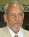
James Fitz-Allen Mitchell, the Vincentian prime minister from 1984 to 2000
-
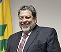
Ralph Gonsalves, Prime Minister of St Vincent and the Grenadines from 2001 to 2025
-
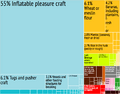
A chart showing what St Vincent and the Grenadines exports

.jpg)

See also
 In Spanish: San Vicente y las Granadinas para niños
